The “Jobs Plan” and lack of leadership

I cast my eyes down, shook my head slowly, rested my forehead in my hands, then had to go outside and get some air. It is rare that a politician so profoundly demonstrates her lack of vision, I had to re-calibrate my cynicism.
What caused me this mental distress strong enough that it caused physical distress? It was Christy Clarke’s “Jobs Plan” announcement at Thompson River University.

Someone has to tell Clark that the industrial revolution is over, that we are now in a post-industrial economy, a “knowledge economy” to borrow Moira Stillwell’s campaign plank. The days when BC jobs used to rely on cutting down trees or digging up dirt are gone. There are a lot of places in the world with trees and minerals, most with more relaxed environmental standards, and many with huge pools of uneducated and semi-skilled workers who will cut the tree or dig the dirt for way less money than the average BC worker. We cannot compete with China in the cheap-labour department. Simple supply and demand, and to race the other countries to the bottom for raw material supplier will destroy the “Greatest Place on Earth”. That is not a future of BC I want to see.

If you want to solve unemployment, if you want to build a home-grown knowledge-based economy, if you want entrepreneurs, wealth-generators, people who can develop the products and ideas that the 21st century needs – you need to have an educated workforce. The only government jobs program that has ever really worked long-term is the public education system.

It has the side benefits of being the most effective health-care program, and the most effective crime prevention program. There are few aspects of a post-industrial society that are not directly linked to the education system.

This is why Premier Clark’s announcement filled me with such dismay. She stood up in front of a University crowd and said she wanted to attract more foreign students, because they pay a lot for an education, and that is, like, free money! At a time when our public schools (K-12 and Universities) are feeling space and financial crunches, at a time when she should be sitting down with the teachers union and setting a course for the decade ahead, at a time when our entire school system is suffering for infrastructure development, Clark’s big plan is to take seats in BC schools that BC students increasingly cannot afford, and sell them to the highest overseas bidders.

Christ, she really does hates teachers, doesn’t she?

This is the public education equivalent of cutting down trees to sell the raw logs overseas. The product of chronic short-term thinking. Who are paying for these seats? People from China, Korea, India, Brazil, the Persian Gulf States. What do these countries have in common? Rapidly expanding economies, and the ability to think about the future. They recognize that an investment in education is the fuel to power their economies. These countries are looking forward at what they can do in the next generation, not back at what the last generation should have been. When will BC have the vision to invest it our own education system, so that the students of British Columbia can compete in the world economy with students from abroad?

This is a failure of vision, and a complete absence of leadership, and speaks very poorly for the future of the Liberal Party. This is a party that cannot afford to drift along on it’s past, because it’s past looks much worse through the lens of hindsight. It needs to look forward. The NDP are resurgent, Adrian Dix is politically astute, is almost as telegenic as Christy Clark, and is clearly brighter. Grampa Cummins will slice off a significant number of “Big C” true Conservatives, who always held their nose when voting for Campbell, because he wasn’t a Socialist. If the Liberals want to have a future, they need a vision, they need to start thinking big, or Christy will be back on CKNW in no time.

I mean, how far can you coast on charm?
More on the Waterfront Vision

Now that some committee meetings are available for streaming at home, we can hear a lot more of the discussion around topics that go to council, discussion that at times is more important than the Staff Reports that are available in the on-line agendas.

The discussions last week of the new vision for Front Street and the Parkade, is a perfect example. Here are a few things I picked up on.

As much as I like green spaces and innovative park design, I don’t want to see half the Parkade preserved as some sort of elevated park/viewpoint over the Pier Park as Councillor McEvoy suggests. Putting a green roof on the white elephant won’t change it from being a white elephant. Making any long-term investment in “improving” the Parkade would be money wasted, as its very existence will continue to be a blight on our waterfront and limit the potential to convert Front Street into human space. Parks should be on the ground, and putting one up in the air that will limit the economic development adjacent is less than optimal.

To hear Councillor McIntosh still talk about further “beautification” of the Parkade was depressing. Her Twitter feed last week read:

“more customers needed to park on Front St. Parkade. Should park ‘n ride be promoted?”

This creates a strange paradox. The Parkade is underused, on average about 25%, up to 38% at peak times. So it seems Councillor McIntosh is looking for way to promote the use of something, in order to justify not demolishing it because it is underused relative to the expense of repairing and maintaining it. I know Councillor McIntosh is on the record as being a “fan of the Parkade”, but it is time to move on. The Parkade is holding back the development of our waterfront, it is a blight on the face of our City, it limits the development of potentially high-value commercial Real Estate on Front Street…it is time to let it go.

I think Councillor Cote put the right stamp on the discussion: the City needs to start looking forward to when the Parkade is no longer there. That will definitely include making some hard decisions about how to accommodate the parking elsewhere in downtown, which will have to follow some sober discussion about how much parking we need downtown. I suspect a large proportion of the Parade traffic is already park-and-ride folks, but there is no doubt downtown businesses can make a compelling case that parking will need to be found for the 200-odd cars that use the Parkade on the average day. I’m not saying tear it down tomorrow, I’m saying let’s start planning for the day we do tear it down, and in the meantime, let’s not dump any money into it. (It is important to note that the City is not, as of yet, dumping money into the Parkade. It operates much like a utility, and has something like a million dollars in its contingency fund. But major refurbishment will be expensive, and I would like to see our money spent elsewhere).

Councillor Cote also points out the importance of connectivity, between downtown and the waterfront, between the MUCF and the Quay, between the Pier Park and Sapperton Landing. If the council elected in November has one “developing the City vision for their term, I hope this is it.

Finally, it was interesting to hear Councillor Harper express his concern about the zombification of the NFPR. When the UBE went down the drain, TransLink made several announcements that the NFPR did not make sense without a UBE, and as such, the NFPR is not a project they are considering further (see final page of this presentation) . Or maybe they said it isn’t a priority. OR maybe they said no such thing. The message has been a little uncertain. I distinctly remember thinking the NFPR was dead after hearing Sany Zein talk to the Public open house, and to Council. So zombie or not, I think we have to take TransLink on their word, and proceed with building the waterfront we want. We have waited 20 years fro TransLink to build the NFPR, and that waiting has slowed down the growth of our commercial centre. Time to cut the cord.

Finally, I disagree with the idea that we need to get the trucks off Front Street to make it a livable, human space. To do that, we need to get rid of the Parkade. We need to clean up the rail area, we need to build a pedestrian-friendly streetscape on the north side, with adequate green space, and we need to build safe crossings of the rails. Keeping the traffic lanes to two lanes and limiting speed to 30km/h is all the traffic control we need. The rails are not going anywhere, and the park itself pays homage to the working waterfront, slow-moving trucks can be accommodated.

Less trucks might be nice, but it will only open up the road for commuters, who will quickly fill the space, and generally drive faster than trucks. This way, we avoid the other big debate: pushing trucks onto Royal Avenue 24 hours a day. There are more than thousand residents of Royal Avenue who know all too well the number of trucks that ignore the night-time truck-closure of that street. This traffic should remain in the commercial parts of town, where the noise impacts are less personal, and affect property values less

The Master Transportation Plan and Models.

A second report to Council that came down last week was an outline on the Master Transportation Plan process. I have railed on about this in the past, and have spent much of the summer letting people know about the MTP during NWEP booth events. All along, we have been telling people it is coming, asking them questions about their transportation issues, and suggesting they get involved in the consultation process if they care about the future of the City.

The report to council outlines how the Master Transportation Plan will come about, and now that we have some details. It seems the first opportunity for public consultation will be during Stage2, and we can expect a lot of initial “community visioning” events like took place during the UBE process.

However, I want to talk about Stage 3, and about transportation models. First, the caveat part: I am not Transportation Engineer, so my opinion here is worth exactly what you paid for it. My expertise is in other areas, so I will be the first to stand corrected by those with more expertise or different facts. That said, during the UBE controversy, in discussions around the NWEP’s transportation forum last year, and by following along in transportation discussions with people like Stephen Rees, Voony, and Eric Doherty (who have a much higher level of expertise than I), I have learned a bit about Transportation Models, their strengths and weaknesses.

My concern about Transportation Models is that they generally fail to accommodate things like induced demand and the traffic demand elasticity – things that are vitally important for planning a transportation system in a built-out city like New Westminster, where the economic and social costs of building expanded road infrastructure are massive.

The basic transportation forecasting model works like this: You draw out a virtual transportation network to match your existing one. You then enter landuse parameters within and outside your study area, which tell you a bit about what is generating the trips (i.e, 30,000 residents here, industrial area there, commercial district over here, etc.). These create a model framework. Then you count your actual traffic, and calibrate your model so the traffic load generated in your model matches the traffic you measure in the real world. Then you take the Regional Growth Strategy off the shelf and apply the projected growth to your model: 10% more residents here, 15% more businesses there, etc. and count what that does to the traffic. If there are trouble spots that pop up, you mess around with your transportation network to make it work as efficiently as possible.

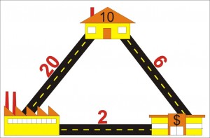
To demonstrate this, I can draw a ridiculously simple model. Let’s say you have a village with 10 houses, one factory and one shopping centre, and they are connected in a triangle (see below). We measure 20 trips between the factory and the house every day, and 6 between the houses and shopping centre, and 2 between the shopping centre and the factory. That is our model set up.

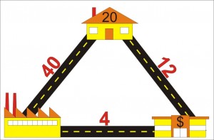
Now let’s say the Growth Strategy indicates we will double population in 10 years. In this case we double the number of houses (and for the sake of model simplicity, keep the factory and shopping centers in the same place, just assume they both double in size). We enter that in our model and presto: we get a doubling of all trips.

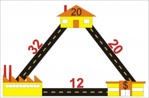
But what if the road between the factory and the houses can only handle 30 trips until it becomes hopelessly congested? In that case, the citizens have two options: sit in the congestion and accept their fate, or go around the “long way” which might take less time if the congestion gets bad enough. Some will choose to go-around until the time is equal on both routes, and the model might look something like this:

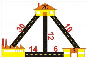
Since citizens hate congestion, they lobby City Hall to fix the problem. City Hall has two options to fix the problem: it can expand the road to accommodate the traffic, so things look like our second drawing up there. Or it can build another route to relieve congestion. (Now we enter into the world of the Braess Paradox, but let’s not go down that rabbit hole just now).

We can do all sorts of messing around with the road configuration to best accommodate the traffic generated by the growth, and this is how we can apply the model to make the most logical choices about how we invest our transportation money. However, (and this is the nut of the matter) it is assumed in these models that traffic (=trips) will grow to match the population increase. Whether you build a road to accommodate it or not is irrelevant to the model.

Let’s say you don’t do anything to expand road capacity. Do we really get 32 trips on the one road and 20 on the other? If 32 trips cause congestion enough to shift people’s behaviour and make them change road choices, perhaps it also induces some to not drive. Carpooling, transit, bicycling, or telecommuting become better options. Maybe building a bus route instead of building a road is better investment – we can move more people with less money (if a bus is cheaper than two more lanes).

With 8 of the trips from home to factory going via the Shopping Centre, won’t this cause people to shop in the way home, and reduce the number of specific trips between the houses and shopping centre? If we don’t build more road capacity to accommodate growth, will the number of trips actually be reduced?

One thing we noticed in the UBE process is that models are really good at predicting increased levels of congestion, but do not accommodate the idea that congestion has an upper limit before people stop fighting it, and find alternatives.

The result? People discussing the NFPR say that traffic on Front Street is at a dead stop, is constantly congested, is completely at a breaking point, then produce models that suggest the problem will only get worse until we fix it. Of course, if the roads are already at capacity, the problem cannot get worse, unless we add lanes in an attempt to fix it.

Transit is a real alternative when it is faster and more efficient that driving (Canada Line anyone?), cycling is an alternative if the distance is short enough, the trip is on safe infrastructure, an there are end of trip facilities available. Moving closer to your work, or working closer to home, is an alternative, when land-use planning makes this possible. Shopping locally is an alternative to driving across town to your favourite Megamart. Moving containers by rail and barge is an alternative. And yes, building more roads an option, but is it the best use of our resources?

Back the Master Transportation Plan, and I’ll be uncharacteristically brief here. Because the vast majority of traffic in New Westminster is through-traffic (something like 400,000 vehicles a day in a City with a population of less than 70,000) most of the factors that control traffic in our City – like landuse planning, growth in the rest of Metro Vancouver, the building of mega-freeways – are beyond our control. Therefore, it is possible that the only control we have is how we allocate our road space. In a sense, the only way we can control out own traffic fate is to manage the implied demand part of the equation. Will the model be the tool to do this?

Keeping it above the (asteroid) belt.

Let’s hope this is an anomaly, and not a sign of what is to come over the next two months, but it looks like the campaign for Mayor is starting to get a little nasty.

There is a lot of veiled language in those exchanges through the media, and I think it is up to me, as an completely independent voter and someone in no way qualified to attach assumptions to anyone else’s use of language to provide a bit of clarity about that everyone is talking about here.

Here is what everyone is talking about, and what these euphemisms really mean:

An asteroid is generally reserved now for rocky bodies in the inner solar system, almost all found within the “asteroid belt” between Mars and Jupiter. Small rocky objects further out are generally classified as Kupier-Belt objects or Trans-Neptunian objects, etc. based on where they are located. Asteroids are different than comets in that the latter are in highly elliptical orbits and feature “tails” of off-gassing volatiles when they get close enough to the sun to facilitate sublimation.

Although they range from dust size, a few asteroids are very large: Ceres is the third largest “dwarf planet” (after the trans-Neptunian object Eris and former-planet Pluto), and is big enough to have collapsed into a sphere under its own gravity. It is about 1/10th the size of our own moon, but it is an asteroid nonetheless.

Clearly, the Crosty press release did not fairly characterize asteroids. It is unlikely any “dirt” would be found on an asteroid (“dirt” is usually reserved for organic materials or organic-mineral mixes, like soil), and asteroids do not roam aimlessly through space, but have been locked in stable orbits around the sun for billions of years. That said, a small group of asteroids in the inner solar system are in orbits that may occasionally intersect the Earth. Small ones will form shooting stars, large ones will cause catastrophic destruction on the planet.

Now, we all know “shooting stars” are not stars at all, but are small objects entering earth’s atmosphere and falling to earth so fast that they cause a superheated shockwave in the air in front of them, and heat up to thousands of degrees. The majority of these “shooting starts” were previously asteroids, although most are dust-sized, with very few as big as a baseball. These burn up 100km above the surface, and only glow for a few seconds at most before they completely vapourize. Only the rarest, largest, and brightest “shooting stars” survive to make on impact on the earth. And very much fewer of these create a big enough impact to be destructive.

But you can’t have a destructive asteroid without if first becoming a shooting star, even for a brief moment.

I think in politics, it is important that we define our terms, especially when someone plays the asteroid card.

Council Reports and Front Street

Summer is over, and the council reports are coming fast and furious. Three this week are worthy of reporting: An update on the Electrical Utility budget, the official launch of the Master Transportation Plan, and a quiet little report on Train Whistle Cessation.

The third of these is of significant interest right now, as the Quayside Board is going to the Federal Court of Appeal on Tuesday to deal with rail emission issues (of which whistles are part of the story) and there is a guy running for Mayor at least partially on a wave of anti-rail sentiment. Additionally, this report provides the best insight so far into how the City’s Development Services and Engineering departments envision the evolution of the City’ waterfront, and I have to admit there is a lot to like here.

Right off the bat, I have to point out this great quote from the report:

“At the conclusion of the UBE public consultation process in May 2011, Translink…confirmed that they had no plans to proceed with the proposed NFPR. City Council has concurred with this conclusion and staff will now work towards ensuring Front Street becomes a more local serving commercial street”

Although I had heard this suggested by City staff in the past, this is the first time I have seen it written in a Staff Report, and the request at the end of the Report effectively asks Council to endorse a vision that reflects this new reality. If endorsed, this may be a watershed moment for the City, and ultimately for the region, as the NFPR joins the East Vancouver Freeway and the twinning of the First Narrows on the ash heap of bad transportation ideas that never saw the light of day.

From this starting point, the report also addresses the future of White Elephant Parking Inc the Front Street Parkade, by reinforcing a previous plan to remove the west half, and refurbish the other half to extend it’s lifespan by 30 years. The money quote here is from the analysis of the past approaches to refurbishing the Parkade. Apparently, previous plans to “beautify” the Parkade ran into some opposition in part because:

”…this area is a favorite [sic] site for filming as it is a good replica of a gritty section of New York and painting the columns would result in a reduction in film revenues”

I had to read that again. Apparently there is interest in keeping this aesthetic blight on our City’s waterfront as aesthetically blighty as possible to provide a more accurate replica of the urban decay of New York City!? (as an aside, New York City provides less suitable locations, as they have seen fit to remove such areas from their waterfront). If this is the model we are going for, perhaps we should start filling the Braid Industrial Area with rusting machinery and to create a more authentic “Rust Belt Pittsburgh” look, or even help with our housing affordability issues by building corrugated tin shanties in Glenbrook Ravine to visually evoke the favela of Rio de Janeiro. Or maybe not.

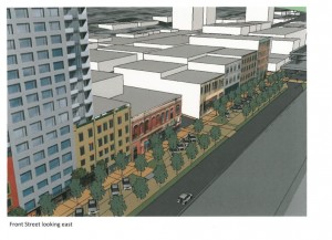
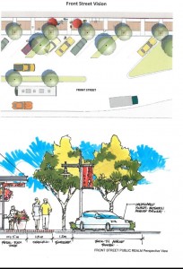
I much prefer the visualizations provided in the report of potential streetscapes with the parkade removed. As I blogged previously, those heritage businesses could be the face of our City.

Image from the Council Report- borrowed without premission, but I am a taxpayer…

As much as I support the removal of half the Parkade, I think that stops short of the true goal here. Any money spent renewing the other half of the Parkade is the result of very short-term thinking. Let’s find a better solution to distribute parking throughout the downtown (e.g. force new high-density developments to provide public pay parking in their undergrounds), or find a market solution to parking needs in the City in a location that doesn’t put a long-term speedbump in our City’s waterfront renewal.

Or course, the elephant in the room is indeed the Larco development. How much longer with it be an empty parking lot? The other side of the coin being how long until it potentially cuts off the stretch of Front Street from the waterfront for ever? How will the newly-envisioned face of front street fare when facing a 4-story parkade under the Larco highrises (a la Plaza 88 and Carnarvon).

Actually, come to think of it, isn’t removal of only the western half of the Parkade really just a necessary step to accommodate Larco? What is the point of that removal if Larco is going to put a close approximation of it right back, only a few metres south on the other side of the tracks?

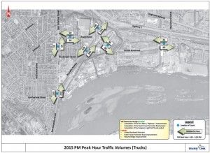
I suspect these issues have been raised, and you can’t solve all problems in a single report to Council. First off the future vision has to be laid out, and I think this document does a good job at that. The report includes some of the strongest language I have yet seen about how traffic will be accommodated on Front Street, pending the City’s Master Transportation Plan. Essentially, the City would like to see fewer trucks on the Front street:

“It is recognized that any reduction away from the constant stream of trucks will immediately improve the pedestrian environment of Front Street and the Waterfront”

Except that it will do more than just improve the pedestrian environment, it will reduce noise for the residents and businesses along Front, it will reduce the particulate pollution Downtown, and it will increase the commercial land values along Front and open up significant opportunities for economic development that are not there now.

As always, click to zoom.

So with some caveats in mind, it is great to know the vision for Front Street is coming together… all the pieces of the puzzle are not there just yet, but for the first time I think we can safely say they are coming together. I think we can be more certain now than ever before that New Westminster’s waterfront will once again be human space, not space totally turned over to through-traffic. Or to quote the report:

“Front Street will be returned to a pedestrian-friendly retail street with historic waterfronts.”

That is a vision I can get behind.

Grand Canyon Part 2: The Kaibab Limestone

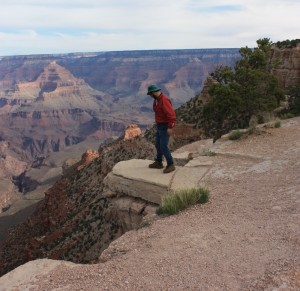
The top of the Grand Canyon, and much of the rubbly plain surrounding it, are made up of rocks of the Kaibab Formation. The Kaibab is a limestone unit, somewhere around 270 million years old, which puts it in the middle of the Permian Period of the Paleozoic Era.

The world was a different place in the Permian. This is a time before there were birds or mammals, even the dinosaurs had yet to develop. The dominant land animals were synapsids, which look rather like modern lizards but were more mammal-like than reptilian (with differentiated teeth and quite possibly fur). They were almost completely wiped out in the Great Permian Extinction (lucky for you they weren’t, as one of your ancestors was a Permian synapsid).

There were no flowering plants in the Permian, but cycads, ginkgoes, and ferns were common. In the sea, 300 million years of Trilobite domination was about to come to an end, and echinoderms and mollusks were rising, especially a new-fangled cephalopod mollusk, the Ammonite, which was starting it’s impressive 200 million-year reign as king of the Sea.

The Permian was also the last time that all major continental land masses were collected together through Plate Tectonics into one “supercontinent”- Pangaea, leading to bad T-shirt ideas ever since (people calling for Pangaea’s reunion rarely consider that the supercontinents correlate very well with massive declines in biodiversity, but I digress). In the part of Pangaea that is now northern Arizona, there was a shallow sea facing to the west, with the shoreline shifting around somewhat, as they are apt to do on million-year time spans, which brings us to the limestone.

Limestone is generally deposited in shallow ocean water as a result of biological precipitation of carbon dioxide and calcium out of the water column – which is a fancy way of saying: it is all shells. Not just shells of bivalves like clams and oysters, but structural parts of corals, echinoderms, sponges, and perhaps most importantly, microscopic plankton. As this pile of dead and discarded shell material is compressed, heated and dewatered, it cements together into a very hard rock: limestone. Well, it is actually kind of soft by rock standards, and it is easily dissolved (on a geologic timescale) when exposed to meteoric water. However, it often forms large, homogeneous blocks that can be very resistant to erosion in arid place, like the Colorado Plateau into which the Grand Canyon has incised.

In places west of the Grand Canyon, younger rocks are piled on top of the Kaibab, but around the canyon, these younger rocks have been eroded away at some point in between the 270 Million years since it’s deposition in the shallow ocean and it’s current exposure more than two Kilometres above sea level.

Did I mention my fear of respect for heights?

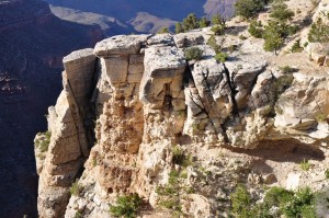
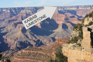
The Kaibab is hard enough to form vertical walls at the Canyon rim, some more than 300 feet high. It is also distinctly grey in colour, making a visible band around the canyon rim, and is easy to differentiate from the reddish sandstones and shales below. The underlying Toroweap formation is not as resistant, and forms rubbly slopes below the Kaibab cliffs.

Kaibab – you can recognize it from 10 miles away.

Close up, the Kaibab is grey in colour, and is variously massive (showing little internal structure) or mottled with chert nodules and fossils. It is also variously mixed with relatively thin shale or sandstones beds, just enough to give a sense of bedding.

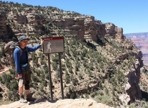
This poor, suffering bastard could use a bed. Fortunately, there is
beautifully expressed bedding in the Kaibab Limestone outcrops behind him!
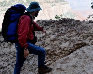
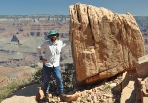
Chert nodules weathering out of Kaibab limestone. Note pointing doofus for scale.

“Chert” is a micro-crystalline form of quartz (more or less pure silica) that is much harder and less soluble than the limestone so it really stands out from the limestone surface. These nodules formed in the limestone when it was buried and hot groundwater with silica dissolved in it percolated through the limestone depositing crystals. These look like fossils, and indeed some of them do form around incongruities in the limestone caused by fossil structures, or in tunnels bored through the sediments on the ocean floor by various animals who might be grazing through the sediment looking for food (like worms do in soil) or making tunnels or tubes to live in (like some types of shrimp or clams might do). These are “trace fossils”, and I will go on at length about them in later posts.

I like trace fossils.

Game ON! -UPDATE

In case no-one noticed, Municipal Election time is here. The Silly Season has begun. I feel like I need to make a few things clear going in.

Over on the right side of this blog there is a title that reads “What this Is(n’t)”. Click that and read. There is a lot of important stuff about who I am, and what this blog is about.

I do other things in the community besides this blog, but this blog is my opinion, and my words. Anything I say about politics is not the opinion of the NWEP or any other organization I work with.

The NWEP is non-partisan, partly because it is a diverse group of people with varying opinions, partly because the NWEP will be working with whoever wins the next election (as they work now with the people who won the last one) to make positive change in the community, regardless of their political stripe.

So entering this Municipal Election, I will be supporting some candidates, and not supporting others. My support does not constitute the support of the NWEP, nor does it constitute the support of the Environmental Managers Association of BC or the Uncle Tupelo Fan Club, or any other group I belong to. I haven’t really decided who I will and will not support yet, but not all of the Candidates have declared yet.

We know all of the current council will be running.

We know Voice will be running Candidates, probably four for Council.

And unless we have been under a rock, we are aware James Crosty is going to take on Wayne Wright for the big Chair.

James Crosty and friends celebrate a successful campaign launch.

We can speculate on who else will be running, but many suspect a certain former Councillor, and a 12th Street Business Owner will throw their hats in the Ring. Any President of any Neighbourhood Advisory Committee is probably suspect. Until nominations are official on October 21st, it is all speculation.

But I will be blogging about the election, and I will send out kudos and criticism to all candidates, as I feel they deserve it. However, my criticizing a candidate doesn’t mean I won’t vote for them, and my sending them kudos doesn’t mean I will. I am entering this election with an open mind, will be watching carefully, and will be voting based on who I think will do the best job running the City and spending my tax money.

The only thing I can promise the candidates, and this goes back to a long discussion thread on Tenth to the Fraser: I will always treat all candidates with respect. If I make fun of them (see image above), I will do so in the spirit of fun, not malicious attack. If I call someone out, I promise to give them a fair hearing. I will stand behind statements I make, and will stand to be corrected. When all else fails, I will agree to disagree. As pointed out in that TttF post, anyone who stands for office is doing a good thing, and we should all strive to create a respectful environment where people are encouraged to take part. That is the only way we will attract the best possible people to serve.

UPDATE – Do we need any more evidence of a Silly Season than this exchange between Mayor Stewart and Mayor Wright?. Moving a 150-year old hospital and regional trauma care centre with 400+ beds and a couple of thousand staff to a less-central location with worse transportation connections, because you have a little bit of empty space available? Good for them for both coming out so strongly in support of their communities, after all, there might be giants behind those windmills.

Council Stream – UPDATE

I guess with the election around the corner, good news is the blue-plate special. The announcement that New Westminster Council will live-stream Council meetings is definitely a good news story.

Like most people, I think democracy needs to operate as openly as possible in order to be accountable. Although I find all of our City Councillors and Mayor to be accessible people, and I have attended many council meetings and volunteer on a couple of City committees, I have sometimes been frustrated with accessibility to Council.

The biggest problem to me, up to now, has been the Monday afternoon “Committee of the Whole” sessions, which are open to the pubic, but are held at a time when most working people cannot attend, and are not broadcast. Even the minutes are not available until weeks later. Often, it is at these committees where the real discussion of topics is raised, and often the motion at the Evening Council Meeting is read and passed, with the discussion already completed in the afternoon. If one is wishing to delegate to Council (as I am wont to do on occasion), it is important to know the context for the discussion coming out of the afternoon “C/W”. With video streaming of the afternoon session (and an archive available on-line for later viewing) the populace can better understand the issue and how Council made the decision it did.

Even the evening meeting have been only partially accessible to those not able to attend in person. They have been broadcast on Shaw TV, but I would hazard to guess more than half of New Westminster does not actually get their TV service from Shaw. Luckily, Matt Laird has been recording and archiving the Shaw-broadcast meetings, and I have gone back to that resource several times to get caught up on NW Council action. I suspect this story from last year at Tenth to the Fraser was a major part of Council’s decision to go this way. Nothing worse than saying something can’t be done, then have someone do it right in front of you. All you Rubik’s Cube freaks know what I am talking about.

This also fills a bit of a gap in our local media. With Print media struggling to make ends meet with reduced income, and with our local electronic media still in the “enthusiastic-and-sometimes-skilled-amateur” category, there is little coverage of the sausage-making of local government. I can’t remember the last time I saw a reporter from either local newspaper attending an evening Council meeting (maybe they are watching on Shaw at home?). That said, I can’t think of a business case for paying someone’s salary to sit in a 4-hour meeting hoping to catch a publishable nugget. Besides, if movies have taught me anything, it is that City Beat reporters are 4 martinis in by 7:00pm.

Now that all the meetings will be available on line, it is only a matter of time before a skilled local video editor grabs some quotes, punches up a little autotune, and creates a NW Council version of this:

Thanks Carl.

UPDATED: Unfortunately, Dr. Heidi was promoting naturapathic remedies to lose weight on the stream at 7:45 tonight, which I’m pretty sure wasn’ t on the agenda. hmmm…. technical glich?

Poplar Island, and a bridge to elsewhere.

It is the biggest stand of trees in New Westminster, and you have probably never been there.

Poplar Island has a rich history, which you can read about in some detail here. For those with stunted attention spans, it has been a rancherie, an Indian Reserve, a smallpox hospital (prison?), a shipbuilding centre, a home, and for most of the last 50 years, little more than a convenient place to boom logs. The history of ownership is about as chequered, and perhaps even a bit uncertain now…

I raise this issue now because some people have suggested that a bridge to Poplar may be a good idea, as part of the project to connect Queensborough’s perimeter trail system to the Boardwalk and Quayside, and finally provide a real community connection to Queensborough residents.

The problem is, attaching Poplar to this idea is a recipe for all kinds of troubles.

First off, that legacy of Poplar creates all sorts of legal issues around connecting to it. With a 100-year history of industrial activity, there is a clear history of Schedule 2 activities, so re-zoning it for Park would be somewhat complicated, even if there is not contamination present (actually, the logistics involved in doing the sampling required to determine if it is contaminated would be a real hassle for an island with no roads, no landing docks, and no services). Then if somehow the City got the rights to use the Island, and negotiated fair use with the appropriate First Nations, and got the contamination situation figured out, how do we go about controlling access to the park, preventing fires, stopping squatters, etc. I suspect there is a reason the island is being preserved in a relatively natural (if second- or third-growth) state…

I hate to be a Debbie downer. I think that a well-designed park, accessible and safe, with a proper emphasis on displaying the important heritage of Poplar, would be great benefit to the City, but it will take a long time and a fair pile of money to develop. Maybe in my second term as Mayor. So the risk here is a measured response to reclaiming Poplar Island will slow down the bridge project, potentially for decades.

Worse actually, is that Poplar Island does not represent a good place to put a bridge, if your goal is to connect the burgeoning communities of eastern Queensborough and their integrated greenways with the Boardwalk, the Quay, Skytrain, and the rest of downtown.
If we want to build a pleasant park trail to be used occasionally for dog walks, then let’s wait until we can get Poplar worked out and build the bridge then. If we want a piece of sustainable transportation infrastructure to connect Port Royal and the rest of Queensborough to the rest of the City, let’s at least put the bridge in a useful spot. That means ignoring Poplar for now.

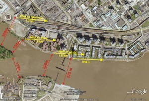
(Click to make big enough to be readable. Hey Google Earth, your share of my profits are in the mail)

As you can see in the above diagram, connecting just west of the train bridge to the trail just east of the little beach on Queensborough would require a bridge about 200m long (measuring between imaginary pillars set on opposite banks). The controversial “Submarine Park” location, more like 225m. Access via Poplar will require two bridges, totalling 325m at the closest points, of 475m to connect to the Third Ave overpass as was suggested by come commentors.

I recognize there is more to a bridge’s cost than a simple length calculation, but as a first approximation, isn’t it safe to suggest a shorter bridge is likely to be cheaper?

The second half of bridge location is that it connects to. As attractive as hooking into the Third Ave overpass may be aesthetically, I don’t think pedestrians from Queensborough are not all that interested in better access to Key West Ford (although I am sure their vehicle deals are second to none). They want to get to the Quay, to the Skytrain, and to Downtown New West and the new MUCF. So why take them so far away from their destination?

I think the Submarine Park is a minor issue, compared to building a bridge that acceptable to the local community from an aesthetics viewpoint, is accessible by more people, and serves its purpose as an important peice of sustainable transportation infrastructure.

The Submarine doesn’t have to move, and in the slim chance it has to, there are other locations it can go. At the Quayside Sale/Festival, I overheard Councillor Harper talking about the bridge with a concerned citizen, and addressing concerns that the “Submarine Park” was going to be removed. He said: “do you really think this Council is going to vote to remove a park?” The question may have been rhetorical, but it seemed to stump the questioner…

What I did this summer – Grand Canyon.

Ok, I am very late starting this blogs topic, because I actually took my summer vacation way back in early June, when my tomatoes in tonight’s salsa were mere seedlings on my window sill and the Canucks were looking good for their first championships. So much time has past.

I still wanted to blog about my trip, however, because blogging about travel was my first introduction to the medium, and because I like to talk about geology. This trip was all geology. I walked down to the bottom of the Grand Canyon with a buddy of mine who shall remain anonymous, but happens to be a Professor of Geology. The purpose was to enjoy the majesty, a once-in-a-lifetime hiking trip, and a chance to get away from spring doldrums, but mostly to look at and enjoy the geology of the Colorado Plateau.

The author with some Coconino Sandstone

For those lucky enough to have avoided travelling with a geologist, it is hard to explain what “enjoying the geology” means. It is startlingly close to what you would do if you were working in geology. We first review the available literature, then look at the rocks, try to identify the rock types, look for recognizable structures, fossils or traces, try to make sense of the structural relationships, or figure out the paleo-envrionmental conditions where they were deposited. Try to point at all of the changes from one “formation” of rock to another, be that a sharp unconformity or a gradual transition. And we take lots of pictures, and talk a lot of rocks.

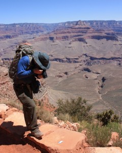
Geologists generally have more pictures of their scale card
than they do of thir kids.

How many pictures? I took about 250 photos below the canyon rim. The Prof took more like 500.

How much talking? We walked down the South Kaibab Trail to the Colorado River, about 12km, and all downhill. Even with the heat and rough trail, most people complete the hike in 4 or at most 5 hours. It took us about 9. After a day hanging at the bottom of the Canyon enjoying the charms of Phantom Ranch, we managed to come back up the Bright Angel Trail in a much more reasonable 8 hours. We were carrying less whiskey this way.

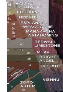
I am going to blog the trip in pieces, in the order of rock formations encountered on the way down (therefore, some pictures form the way up will be mixed in with those from the way-down). That way, the narrative will be a journey backwards through geologic time, more than a tour through our three-day trip. Remember, Law of Superposition: the rocks at the top are the youngest, the rocks at the bottom oldest.

Simple section of the canyon, modified from wikipedia.

This section shows the names of the major rock formations one encounters walking down the canyon, from the Early Permian Kaibab Limestone (about 275 million years old) at the top to the Precambrian Vishnu Schist (probably 1.7 billion years old). Add to this the Laramide Orogeny, resultant uplift, and 2 million years of melted snow runoff from the Colorado Rockies, and you get yourself a canyon drawn grand.

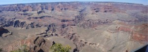
Click to make grander and more panoramic.

Details to follow…

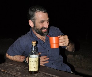
It wasn’t all fun and games.
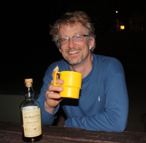
Happy 50th, Prof!