There is some debate about where these Nanaimo Group rocks were, geography-wise, when they were deposited. There is no doubt they were deposited into an ocean, facing west, near a coast open enough that they were subjected to large hurricane-force storms on a regular basis. Most of the geology and the palaeontology suggest they formed in the temperate Proto-Pacific (just a little south of where they are now), but there is a pretty interesting body of geophysical data suggesting they were much further south in the tropics, around present-day Baja Mexico, when they were formed. The “Baja-BC Hypothesis”. I for one side with the geologists over the geophysicists, purely on a weight-of-evidence argument, but that is neither here nor there.
The Geoffrey Formation rocks of Saturna were deposited as part of a submarine fan complex. They were deposited in the ocean, deep enough that surface waves, even during the biggest storms, did not effect the sediments on the ocean floor. They were influenced, however, by large submarine “turbidity flows”, or large landslide-like events that occur occasionally in the ocean. Walking along the shores of Saturna, the evidence of these events is written large on the rocks.
In the ocean, sediments are deposited fairly slowly. As the currents away from the shore are pretty gentle, it is only fine materials like silt and clay that get out there to be deposited. The sand and coarser material is washed around on the beaches and near the shore, and is constantly re-worked by wind and wave and bugs in the soils, but there just isn’t enough wave energy to move them our very far out into the ocean. The exceptions are big storms, which can ramp up enough of the wave energy to move much of the sand and gravel built up on the beaches further out to sea, or big flood events along deltas, when there is a big migration of river sand out to the delta front. For the most part, however, the coarser sediments get to the shore (or just offshore) and basically stay there, building up over time into big, unstable, shelves of loose material.
To quote Thom Yorke: gravity always wins. When these shelves build up large enough, they eventually begin to fail along submarine canyons. When large amounts of water-saturated sand and silt, with a little gravel mixed in, begin to move under water and flow down these submarine canyons, they do so in the form of “turbidity currents”. These high-speed flows of are a lot like the “mudslide” that just buried Highway 1, but because they are underwater and are water-saturated, they behave very differently. The turbidity of their flow keeps them suspended on a laminar base, and they can therefore move very far along a shallow slope with little energy loss. Most remarkable is what happens when friction rises to a critical point and overwhelms the forces keeping the flow moving: the sediments almost instantly “freeze” in place. This makes them very distinctive from river sands or beach sands or even dunes in a desert, where the constant working by currents result in complex structures like cross beds and dunes and ripples.
Fancy as this may sound, I’m not making this shit up. We know these things happen because we can go to places like the modern Indus Fan or even the Mendocino Trench and see these things operating today. Geology is great that way: uniformitarianism rules all.
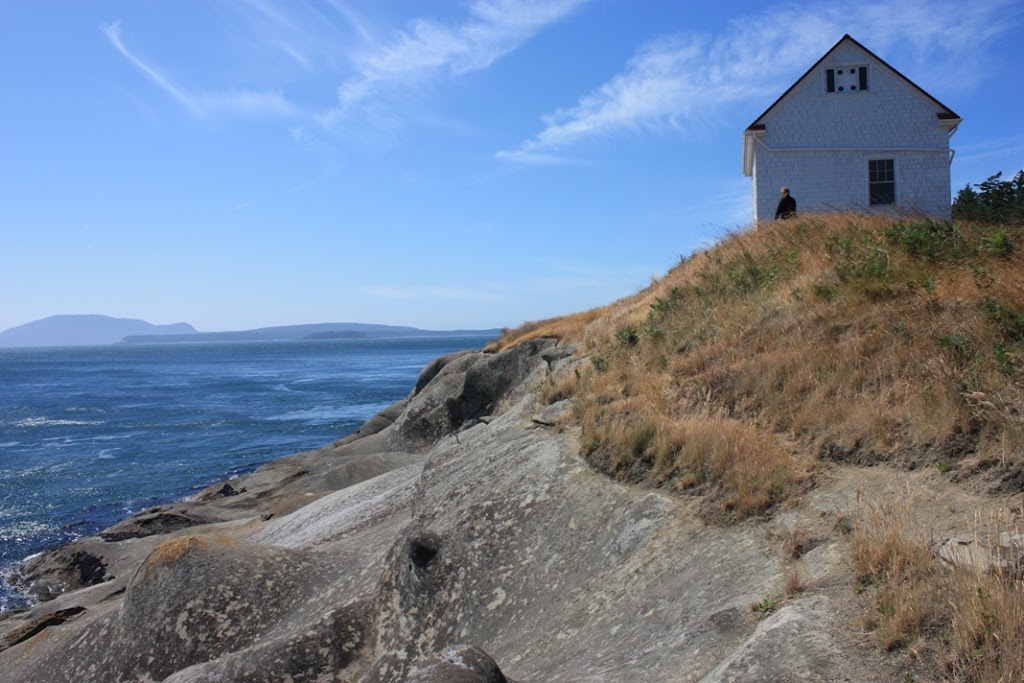
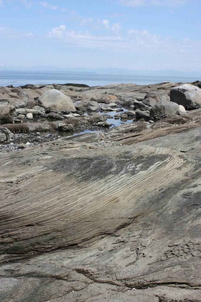
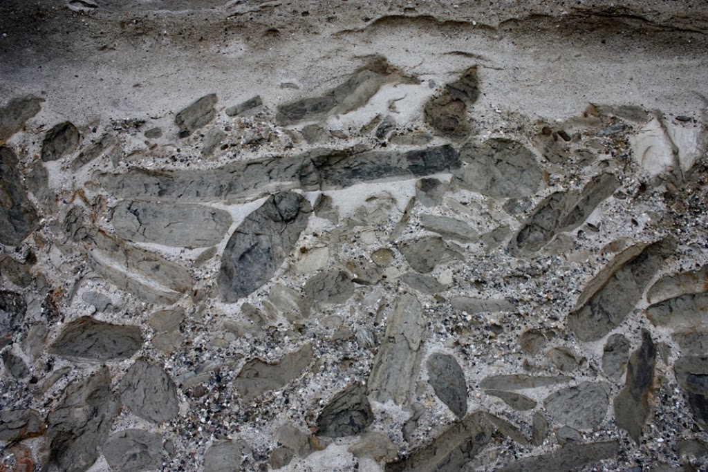
Even more fun with the submarine fans is that the material they transport can include the fine gravel or coarse sand moved out to the shelf by floods or storms, along with the layers of fine mud deposited in the calm deep ocean, and fossils from boththe shallow water and from the deep water, and even pieces of terrestrial plants like logs and leaves, flushed into the shallow ocean, all mixed together in a chaotic matrix. At East Point on Saturna Island, we can see the deposits of all this.
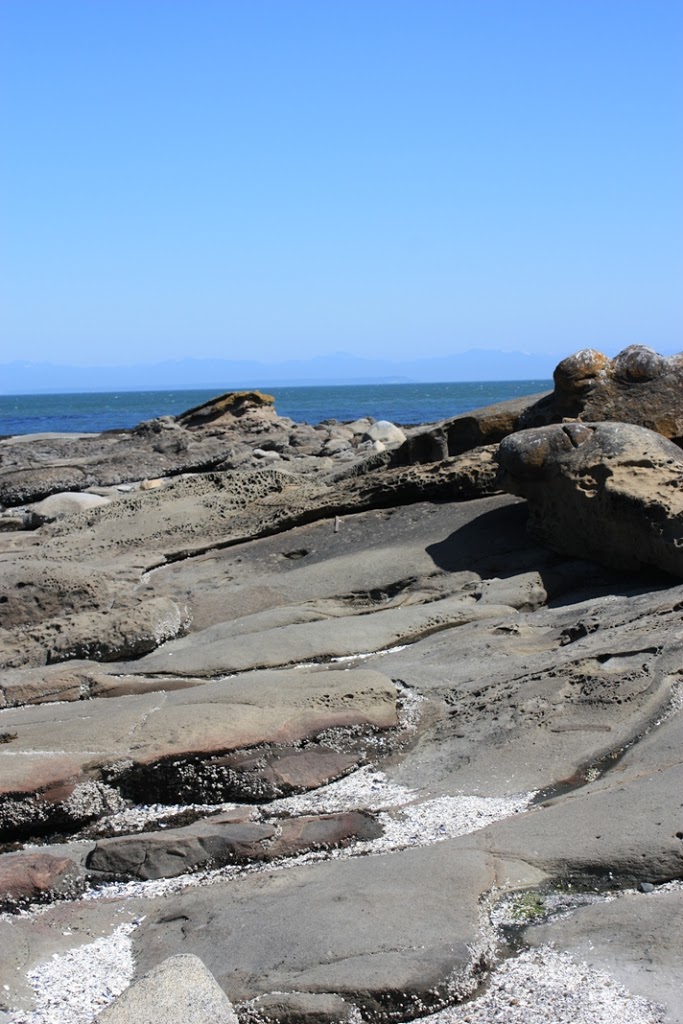
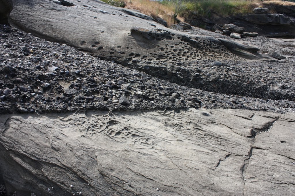
Mostly, the Geoffrey Formation sandstones at East Point are thick and massive, with only minor interbeds of pebble to cobble conglomerate, and only widely dispersed silty mudstone layers. The sandstone represents the bulk of the material stored along the shoreline (not too dissimilar to the sand built up off the coast of Vancouver Island now, to hundreds of metres of depth), and the bulk of the material that filled those submarine channels when there were turbidity flows, and they are the material that sometimes “froze in place”. These massive sandstone beds (“massive” in geology does not mean it is really big, it means that the entire bed is homogenous, without cross beds or ripple marks or bedding planes) are the beds that tend to erode in a pattern known as “taphoni” or honeycomb weathering, one of the most distinctive features of the sandstone of the Gulf Islands.
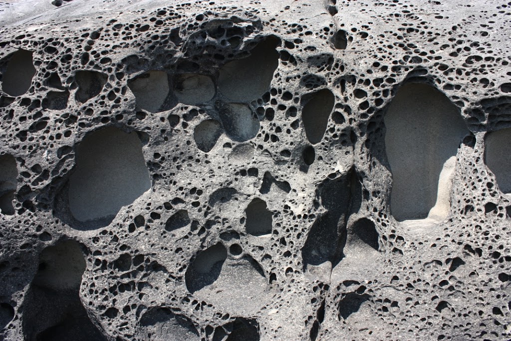 |
| “taphony” weathering |
There are also a few conglomerate beds mixed in with these sandstones, where material from closer to shore was swept out though one of these long canyons. This material is more dense than sandstone, so it concentrates along the bottom of the flow, where it erodes into the underlying sand material and creates a sharp contact on the bottom of the bed. Sometimes other material is mixed in with the gravel, especially shell material, now fossilized.
 |
| Gravel bed, note “sharp” contact at bottom where gravel eroded into soft sand, and more gradual shift to sand on top. |
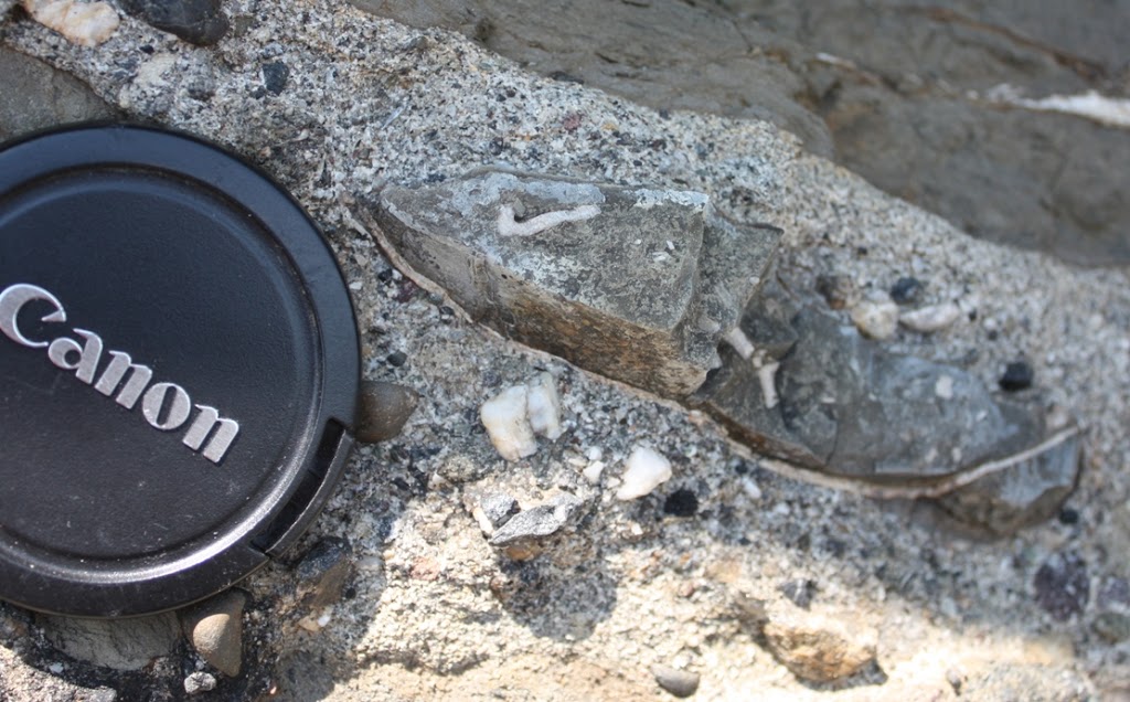 |
| That big oval to the right of the lens cap is actually a section through a bivalve shell, which got broken up as it moved along with the graveland sand, but preserved finer mud material from where it was living within it’s hollow. I’m not a paleontologist, but that there is a ~70 Million year old clam of some sort. |
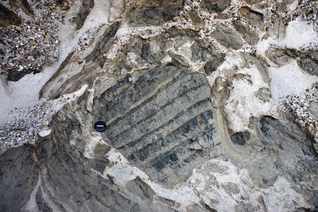
But on the south edge of East point, down by the water is a really special bed. Collected along the bottom of a bed are polygonal hunks of mudstone. These chunks often have bedding structures within them, showing the mud was laid down gently over time, with only the faintest traces of currents in thin silty interbeds. Often, there are trace fossils, showing that some type or animal eked out some meagre existence within those mud beds.
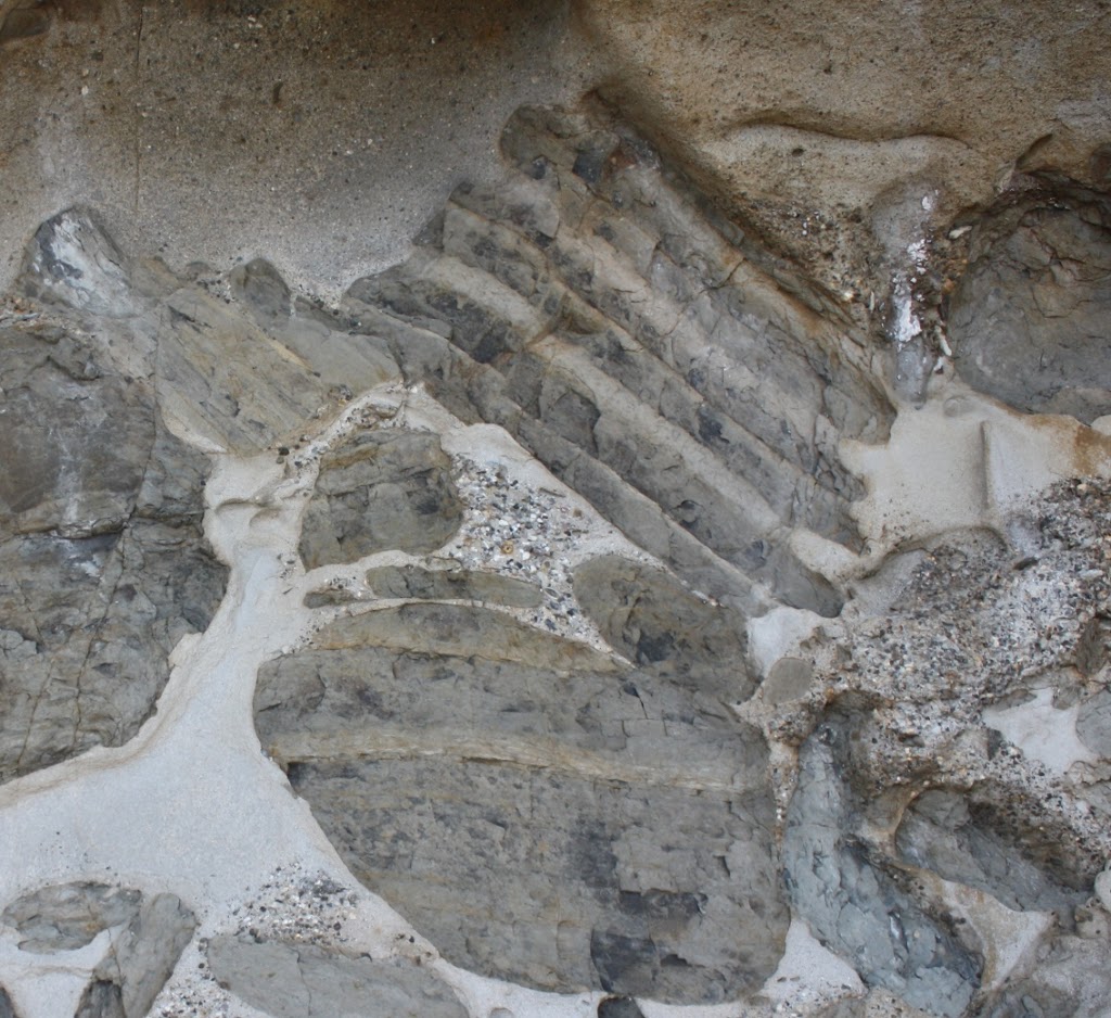
Note the bedding is only within the chunk of mud, which is oriented chaotically compared to the sandstone beds, and compared to the bedding in other chunks of mud. Also, the edges of the mud chunk are broken up, or even bent. These big mud balls are colloquially called “rip-up clasts”. They are literally hunks of soft sediment deposited on calm water then ripped up by the turbidity current and swept along in the flow. We know they were pretty firm and compacted, because they didn’t completely break up in the flow but remained cohesive and moved along like a wet pile of cardboard. We know they were soft sediment and not “rock” because they were easily folded, bent and had their edges eroded by the flow. They are mud, so they are denser than the saturated sand, and collect towards the bottom of the flows, and are mixed in with gravels and fossil fragments. When the flow stopped, they were “frozen in place”, without the ability to fall into a layers. The result is some pretty amazing patterns:
So there I was, on a Gulf Island long weekend, looking at a rock sideways and making up stories of their origin. Drives the iCandy crazy.
 |
| Ubiquitous Gulf-Island-sunset-from-the-pub shot. |
Very interesting discussion about the Saturna sandstone at East Point. I’ve been there and the sandstone is something indeed. Great place to view orca up close too. There is a steep drop off west of the museum where the whales come up to the edge of the drop off. They came within ten feet of where I was standing