jectoons asks—
With the new Transport 2050 plan out and the goal of lowering speed limits in urban areas to 30km/h, what is the expected timeline for those changes to take effect in major New West arteries? (Royal, for example).
Also, regarding the 850 km of protected bike lanes, is there an estimation of how much of that will be devoted to our city? Is there a timeline and map in the works? The official plan for the city reimagines Columbia street beautifully, but I wonder when will we actually see those changes applied. (Not a complaint, I know it takes time for these things to be approved and worked on). Thanks for all you do, Pat.
Indeed TransLink has adopted a new long-range plan that creates inspiration for the region’s transportation in the decade ahead. And there is a lot in there:
The theme is “access for everyone”, and there are laudable goals:
And there are 350 pages of this. If I can get my minor complaints out of the way, it leans a bit too much into unproven tech solutions and benefits of unlikely automated vehicle adoption. My slightly bigger complaint is that it leans much more on other orders of government doing their bit to see the plan succeed, with not enough emphasis about what TransLink can do and should do with the power it holds. But I want to get those gripes out of the way, because it is overall a good and forward-looking plan that draws a positive vision for regional mobility. So I encourage you to thumb through it, because here I’m going to only talk about your questions.
The proposal for reducing urban speed limits is outlined under a section where the plan looks toward a Vision Zero approach to reducing fatalities and deaths in our transportation system. The plan calls for: There is a good defense for going in this direction in the plan, and to Active Transportation advocates, there is nothing surprising there. 30km/h saves lives, and makes shared spaces on our City streets much more comfortable for all users. It also allows us to start re-thinking how we design our streets. I talked a bit about that back here when it came up in Council, and New Westminster is one of a group of Municipalities advocating for the Provincial Government to make the change to 30km/h default speed for neighbourhood streets. We have also started to transition roads in select areas around town to 30km/h, and there are promising signs the Province is looking to make it easier for Municipalities to do this.
Which all raises the point that TransLink can advocate for this, but has no power to legislate speed limits. It will be up to the Provincial Government to loosen up the regulatory control on speed limits in the Motor Vehicle Act, and individual Local Governments to adopt these new relaxations.
That doesn’t mean that TransLink adopting this as a policy direction is meaningless, though, as one limit on Local Governments more widely adopting reduced limits is the Major Road Network. These are roads across the Lower Mainland that are shared jurisdiction between Local Governments and TransLink. In practice, that means TransLink gives local governments some maintenance money for them in exchange for some regulatory control over them. If we want to add a new intersection with traffic lights or add a left-turn bay or reduce lane widths or speed limits, we need approval from TransLink to make those changes. The Major Road Network includes the blue lines on this map: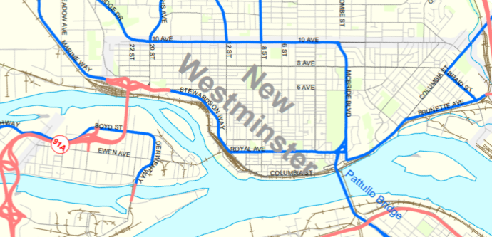
So, if we want to make (your example, not mine) Royal Ave 30km/h, we would need permission from TransLink, and if 30km/h meets their strategy goals, that should make it easier to get that permission. But to be honest, I don’t think Royal will be a priority for that change. At this point, the push for 30km/h is concentrating on neighbourhood roads, collectors, greenways, and pedestrian-dense commercial streets – a work in progress that will advance greatly in the next year or two I hope. The regional arteries like this are not likely to see any change until we actually adopt a Vision Zero strategy, instead of just talking about as something we aspire towards. More on that later.
On the 850km of bike lanes, there is a map in the TransLink plan:
…and my back-of-envelope calculation of this puts it at about 24km of New Westminster, mostly the existing Central Valley Greenway, Crosstown Greenway, and BC Parkway, but with some notable “gaps” in the existing system patched. There is no timeline (except “2050”), and there is no established budget for any of it. But it is an aspirational target, and with senior governments getting into the funding-active-transportation game and municipalities ramping up their work, it is good to have a regional framework to hang our efforts on.
If you are looking at what New West is going to look like in coming years, I put forward a motion passed unanimously by Council in October to start the work on planning a AAA network in New West, which I wrote about here. Staff and the Sustainable Transportation Task Force are engaged in doing the preliminary work of designing what that local network should ideally look like – because the sketches in my blog are just sketches on a blog, and designing these routes requires more thorough analysis by actual experts. You should expect the City to be coming out to the public with some consultation on this in the months ahead. I would suggest the TransLink network will be a major part of our core network, but not all of it. Like speed limits, it’s good to know they are on side.
As for Columbia Street, There are some fresh ideas for the area around New West station and a few key traffic management and public realm improvements on paper, but I can’t tell you the timeline for those. There is some money in the 2022 Capital Plan for some works at the foot of Eighth to improve the pedestrian realm, but the rest will compete on the priority list with improvements in other area. Our capital plan is aggressive, because there is a lot going on.
Finally, I don’t want to get back to complaining, so I’ll try to frame this as an observation triggered by my re-reading the Transport 2050 Plan in preparing this post, because this isn’t a TransLink problem so much as a North America problem. We are much better at talking about Vision Zero than we are at actually understanding it. You can read more about it here, but I am afraid we are starting to use it as a slogan, when it needs to be a change in mindset.
As an example, the Translink plan is to reduce traffic-related fatalities by 5% a year and to zero by 2050. Currently, about 100 people die in traffic fatalities in the region every year, and 40 of those are vulnerable road users (pedestrians, cyclists, or people just standing in a bus stop when a car plows them down). The cynical part of me sees this as planning for 95 deaths next year, and planning for 60 deaths in 2030, etc. This looks particularly unambitious (and slightly macabre), and unambitious considering there are true Vision Zero jurisdictions about the size of Greater Vancouver that have *zero* Pedestrian deaths in the typical year. Yes, they exist.
This is not on TransLink to fix – it will take coordination between all levels of government, a pretty fundamental shift in the Motor Vehicle Act, a shift in how we enforce traffic safety, a new approach to managing investigation of traffic deaths to better understand the causes, and re-engineering parts of our transportation system based on those results. But it is that coordinated effort that defines a Vision Zero approach. The vision is for zero deaths right away, not 30 years from now. 30km/h is part of it. Safe AAA bike networks are part of it. But unless we lose the attitude that people dying from car “accidents” is an unavoidable part of our society, they are going to continue to die at increasing rates. I want us to do better, and I’m afraid the provincial government’s emphasis on reducing the cost of driving is working against this.