I went for a bike ride the other day.
I go for bike rides lots of days, but what made this unique was I decided (against all experience and reason) to go for a bike ride in Coquitlam. Mostly, I wanted to check out progress of cycling connections around the new Port Mann Bridge.
Remember, bicycle and pedestrian access is a “a key goal of the PMH1 Project”, and the plan is to have a bike and pedestrian path crossing at Port Mann for the first time since… well, since anyone remembers. And with all the breathless excitement of the opening of the new bridge (tempered somewhat by the bridge’s sudden violent temper), the introduction of tolls, and New West suffering under the weight of the toll-free alternative, I thought I would pop over to Coquitlam and see what the new bike path looks like.
Except, of course, the new bike path isn’t done yet. And there is no mention anywhere on the PMH1, Gateway, or Ministry of Transportation websites suggesting when or if it will be done. I sent an e-mail to the Gateway people and got this in reply:
A key goal of the PMH1 Project is to improve cycling connections throughout Metro Vancouver, and when the project is complete, cyclists and pedestrians will be able to cross the Port Mann Bridge for the first time.
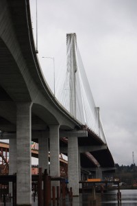
When the bridge opens in its final design, it will have 10 lanes and one multi-use path on the east side of the new bridge. The multi-use path will have a barrier-separated, three metre-wide cycling and pedestrian path. A portion of the existing bridge must be dismantled to complete the final two lanes on the south approach. Given this, the multi-use path will be complete when the final two lanes are opened. We are in the process of finalizing a schedule, but we anticipate this will occur by the end of 2013.
So cyclists and pedestrians will have to wait another year or so before they get to use the bridge, but it is still a “Key Goal”.
Until then, I can speculate about how useful the bike path will be, considering its connections on the Coquitlam side, and I can lament the abhorrent situation created by the construction of the bridge in the first place. Hence, my little bike ride.
Riding through New Westminster on the Central Valley Greenway is a relatively painless experience. The CVG is not perfect, but it is a pretty good second-generation bike route. Even with a few strange connections on the New West side, it is easy to follow, and at no time is it really unsafe. Trying to connect to Coquitlam, that is when you enter the danger zone.
Dropping down behind Hume Park on the bike path to the Braid Station, the Coquitlam-bound have two options: The Baily Bridge to United Boulevard, or the Brunette Overpass to Lougheed. The second isn’t really an option: it is a confusing jumble of lane-changing highway traffic with no shoulder and an uneven and intermittent sidewalks, leading you to nowhere but more killer intersections. Meanwhile drivers are jockyeying for the hole-shot of the on-ramp merging just before exit or the gap in traffic on Brunette to make the suicide turn off the off-ramp (both definitively not looking for cyclists). I’m an aggressively hyper-aware and experienced bicycle commuter (I worked as a bicycle courier in downtown Vancouver in the late 1980s!), I can move a bike through urban traffic like few people. The Brunette overpass area is too scary for me.
So that leaves us the Bailey Bridge to United Boulevard option. The bridge is ok, wait your turn in the line of traffic and occupy the entire lane so the irate guy behind you cannot pass. United past the Golf Course is currently pretty good, because it was built as a 4-lane but currently has two lanes, so lots of room. It was noted by cycling advocates during the UBE discussions that it is certainly not wide enough for four lanes and a reasonable bike path. TransLink’s inability to commit to widening United to make it a safe bike route was one reason regional cycling advocates lined up against the UBE, even with a bike path on the UBE being a “key goal”.
things get much worse once you get past the new King Edward Overpass (with its luxurious pedestrian and bicycle lanes). United Boulevard is narrow and curvy, just barely wide enough for its four driving lanes. No sidewalks, and certainly no shoulder. Add to this numerous poorly-marked driveway entrances and exits to the commercial and industrial sites and a completely disregarded speed limit, and this is one of the least safe roads for cycling in the region. Yet, there are no alternatives. There are no connecting roads at all to the south. Lougheed is a high-speed high-volume freeway with double-lane turnoffs. Brunette Ave through Maillairdville is only better than United in that there are enough traffic lights to slow traffic a bit. The simple message is that Coquitlam doesn’t want people riding bicycles.
The City of Coquitlam does produce a Bicycle Route map, you can see it here. It is pretty much what you expect, disconnected lines with a few routes, featuring more gaps than actual connections. So once the new bike route accross the Port Mann is built, where is it going to go? Who the hell would ever use it?
According to Gateway plans, it will connect to Lougheed Highway on the north side. This should, at long last, provide the people of Surrey the safe cycling access to Mackin Park they have so long awaited. Or perhaps, they can ride to the King Edward Overpass, and watch 10 lanes of cars vroom by below. Fun for the whole family.
What Coquitlam does have is those kind of bike paths preferred by people who don’t really ride bikes for their utility, but as an alternative to playing tennis or bocce. The short multi-use bike path through the park, where one can drive to and park easily, take the Canadian Tire bikes off the rack, spin around for a half an hour. A great example is the path connecting Maquabeak Park under the old Port Mann to Colony Farm Park (as you can see on the Coquitlam Cycling map). It is not really suited for cycling, is guaranteed to produce user conflict, and doesn’t really go anywhere.
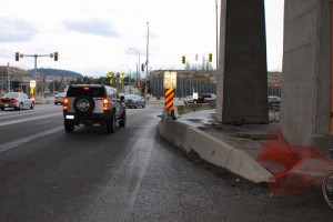
Even this sub-optimal trail has been wrecked by two years of Port Mann construction. With construction staging on top of the old trail, there are signs indicating some sort of detour:
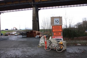
But no actual map or diagram or even arrow to tell you where these detours are. I looked on the City of Coquitlam website, the Gateway one, the MOT and transLink sites after I got home, and I’ll be damned if I can find a map of the purported detour anywhere. so I cannot even blame my complete lack of preparedness for this adventure.
So it was back on United, still bereft of sidewalks or shoulders, but now enhanced by highway on-ramp and off -ramp traffic. Until I was greeted by this:
And this:
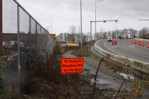
I had apparently found the detour. It went right by this spot:
So what’s the point? When it comes to bicycle access, Coquitlam is a disaster. Combine their incompetence/disinterest with the Ministry of Transportation/Gateway™ aggressive dislike for non-automobile users, and the result is a horror show of pissed away taxpayer money.
The $5 Billion Gateway™ program will, they triumphantly declare, provide “an estimated $50 million in pedestrian and cycling improvements.” Which is, apparently, “the largest single investment in cycling infrastructure in the region”. I would love to be excited about this “investment” in sustainable transportation that represents 1% of the budget, except for two things: It is a sham, and the results will be useless.
The MoT/Gateway™ plan for that $50 million can be read in this report (at least that is the most recent information we have). Aside from including a bike path on the new Port Mann Bridge that won’t connect to anything useful, (at maybe a marginal cost of a couple of million dollars?) it isn’t about building bicycle or pedestrian infrastructure at all. It is about “accommodating” bicycles and pedestrians on the expanded overpasses they have to build to span their shiny new megahighway. Essentially, replacing the current sidewalks and leaving enough shoulder room to paint a white line.
It actually gets worse on the South Fraser Perimeter Road, where the “cycling infrastructure” investment is going to be painted bike symbols on the hard shoulder of a limited-access 80km/h 4-lane truck route. Look at these pictures from the official SFPR website:
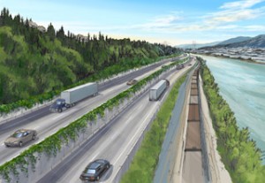

See that space between the semi truck going >80km/h and the concrete wall? That’s “bicycle infrastructure” in which they are investing your tax dollars. Looks like a fun place to take the kids for a spin, eh? Why not just call it what it is (pull-off space so stalled vehicles don’t slow the rush of progress traffic), and quit with this shell game accommodation-as-infrastructure bullshit.
If MoT / Gateway™ was really interested in improving cycling infrastructure, they would hand that $50 Million to TransLink or the municipalities to invest in real, useable bicycle infrastructure where it is needed and where it will be used.
In the meantime, I suggest everyone avoid taking bike rides to Coquitlam.
Excellent post, thanks for this.
I have ridden name times from east Maple Ridge to Vancouver and once out of Maple Ridge, cycling is fairly good until one reaches Shaughnessy @ Mary Hill where I take path of sorts along the south side that takes me under the Port Mann Bridge. It’s terrible and dangerous and continues to be so until I get to Braid Station and get onto the CVG. I’m so glad someone else finds this bike path a sham in Coquitlam. I would like to know where the monies went. Thanks again for the article.
So far so good on the cycling connections around the port. Thanks for adding the sketch plan as well as for pointing out your thoughts in that PMH1 project.
Looking for information on the biking across the new Port Mann bridge, I came across your very informative blog. A couple of years ago I decided to try the Golden Ears bridge, and found all the hazards you describe in Coquitlam, but I thought you might like this additional one that I came across: https://picasaweb.google.com/lh/photo/1UwfXY91PrSYDVJPWGtImdMTjNZETYmyPJy0liipFm0?feat=directlink
After spending hours to trying to find a safe route to bike from Coquitlam to New Westminster, I was not successful. It was refreshing to find this post and very informative. I wanted to start biking to work this summer but looks like it won’t happen anytime soon.
FYI
The city of Coquitlam has contracted a local engineering firm as of last summer to prepare a new commuter bike route design through the industrial streets south of United Boulevard. Specifically because United is a death zone from King Edward to the Port Mann. The proposed route connects to the Gateway greenway on the East and goes all the way to Bailey Bridge. The portion from King Ed to Bailey Bridge is to be a 3.0m wide dedicated pathway with concrete barrier protection on United Boulevard. Engineers contacted the engineering department in New Westminster to see about a partnership to complete the pathway upto the nearby skytrain station including a pedestrian only bridge crossing but was fruitless in those inquiries. Not sure what has come of the project since last summer. Some of you may have noticed a recent court ruling regarding the Bailey bridge and it’s future, expect to see a new one with multiple lanes and generous pedestrian/cyclist facilities in the works.