GM asks—
Hi Pat, found you website and it is a hidden gem! So many great content. My name is Gilbert and I’m about to move New Westminster from Coquitlam. I’m about to purchase a house near 22nd Skytrain. I heard about the 22nd master plan and thought it could be good opportunity for me to enjoy the commute while ride along the development with the city. Do you have any insight on that area? Looks like the city suspend the OCP due to pandemic. Thanks in advance!
Right off the bat, I need to say: Ask Pats are bad places to ask for real estate advice. Besides me just being really slow to respond (sorry!), these are my blogged thoughts, not official City communications. Any speculations I may make need to be recognized as just that, and not something to base important decision-making upon. If you bought a house in New West, great! If you are selling one in New West, hope things go well. But for the love of all that is Hyack, don’t use this website to inform either of those decisions!
The area around 22nd Street Station is known as Connaught Heights, and is an interesting neighbourhood. It is the “last piece” of New Westminster, in that it was not even an official part of the Municipality until 1968, which is why it is slightly out-of-phase with the rest of the West End. One way this has manifest is the lack of sidewalks. Before the local economy went (to use the technical term) into the crapper around 1970, the City generally built sidewalks on all its streets. The 1970s downturn meant investments like this slowed down, and by the time it recovered we were into the modern “get new builders, not taxpayers, to pay for new infrastructure” phase of civic planning. With so little new building in Connaught Heights, it mostly didn’t get done. (The City has started a program to build sidewalks in Connaught Heights as part of the new Master Transportation Plan, supported by TransLink and starting with a new one up 21st Street).
There is other strange legacy stuff in Connaught. The BC Hydro right-of-way where a major over-ground utility line crosses sort of diagonally thought the neighbourhood leaving a somewhat fallow “green space” that some residents use for recreation. The re-alignments of the Queensborough Bridge landings, the swath the SkyTrain runs though, the cut of Southridge Drive and the weird connections to “old Marine Drive” make Connaught a bit of a stand-alone island of a neighbourhood from a transportation sense. This was made more so by varying ideas about traffic calming introduced over the years.
Whatever the cause, the neighbourhood hasn’t really changed in form since the Skytrain station was installed in 1985. It is still mostly single family detached homes, with one low-rise apartment building, a big church and a little school. It’s worth noting homes are still being replaced on a fairly regular basis, but always with larger lot-maximizing houses. This is not resulting in “growth” in the traditional sense, as the Connaught neighbourhood has essentially the same population it had 20 years ago (in the most recent census in 2016, Connaught was the only neighbourhood in New Westminster to shrink in population).
This is relatively rare for neighbourhoods with SkyTrain stations in the middle of them, and at odds with the regional emphasis of Transit Oriented Development. There are a few other stations with single family homes across the street 35 years after station opening, but with the possible exception of 29th Avenue in Vancouver, no transit hub has been as persistently low-density as 22nd Street.
Why? Someone smarter than me wrote a theses on the topic. It is especially interesting to read Chapter 6 of that thesis where a bunch of reasons why are discussed. Turns out the reasons are myriad, including City plans that didn’t encourage change, the difficulty of assembling single family lots, and a general sense that the community would resist significant change:
In the Current Official Community Plan, most of Connaught Heights is listed as a “Comprehensive Development District” whose land use purpose is described as: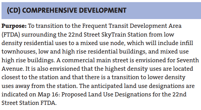
In a way, this makes it similar to the Brewery District or the Sapperton Green area. The vision would be to create a single “Master Plan” for the area so that new housing, utilities, amenities, and transportation can all be planned together. There is a map in the OCP that gives some preliminary vision of the neighbourhood, with mixed use centered on 7th avenue, with the RH and MH being high density (towers), RM being middle density (likely 6-storey) and RT being ground-oriented townhouse style: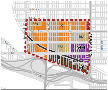
However I need to emphasize this is a very preliminary guideline, and through the Master Planning process, a more refined land use plan would be developed, taking into account transportation, amenities, interaction with the SkyTrain and adjacent road network, protection of green spaces, etc. etc. It may end up very different than this map, or even different than what pops out of the Master Planning, as priorities and economics change over the life of a long-term project like this. The initial plans for the Brewery District did not anticipate the shift to Purpose Built Rental that the community has seen, for example, and we have still to work out some details of the last building on that site.
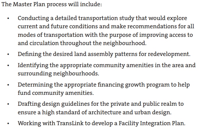
The difference between this and the Brewery District or Sapperton Green is that the latter are owned by a single company, so the work to create this “Master Plan” could fall on them, with guidance from the City and engagement with the community. 22nd Street is still single family homes with separate owners, so if a Master Plan is to be developed, it will fall on the City to do that work. The OCP outlines a plan to start that work:
As you suggest, that planning work has been kicked down the road a bit. Partly because of limited staff resources, and Council’s decision to emphasize different work like supporting affordable housing, rental protection regulations, and supporting development review for projects already in the application process. This was more recently punted further down the road when we had to re-prioritize work in light of COVID and some other emergent policy development areas.
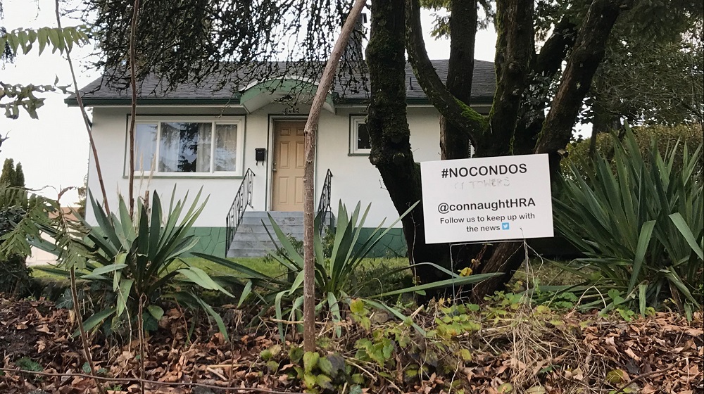
So, the area will change, lawn signs notwithstanding, but I really don’t know what the timeline is. Either the City will develop a Master Plan and the development community will respond by assembling lands to bring it to fruition, or the development community will find some unlocked value in the area and force the matter by assembling ahead of time and drive the Master Planning. However, a lot of pieces have yet to fall into place, and as we see the slow pace of development in Sapperton Green or perhaps a more similar parallel the “Eastern Node” in Queensborough, this type of change can take a long time.
Has there been any interest on hydros part to bury the lines and free up those green spaces for affordable rental housing?
No. Hydro is unlikely to give up their elevated right-of-way or pay to bury those distribution lines. They represent a regionally significant connection between a big substation in Burnaby and Lulu Island. My understanding is that burying them would cost a lot of money and create potential maintenance risk for BC Hydro that they simply couldn’t justify. That said, they have been increasingly friendly with the City about allowing use of the area under the lines for passive improvements like a pollinator garden.