I know it isn’t really a New Westminster story, but there has been some local twitter buzz about the recently-announced changes in Ferry service, and I ride ferries a fair amount, so I have opinions… and that’s what you come here for, no?
First off, I do regularly ride the Southern Gulf Islands routes, as the NWimby-in-Law lives on the Jewel in the Strait that is Saturna Island. Saturna is the south-eastern most Gulf Island, and has a permanent population of about 350 people, although the population can swell to over 1,000 on a sunny summer long weekend. I note there is virtually no camping or hotels on Saturna; that summer swell is people fortunate enough to have “vacation property” or to have relatives or close friends on the island. The fixed population is just big enough to support a store and a pub, as long as the owners of both are more interested in serving the community than in making significant profits. It is a friendly, small community, and Beautiful.
It is also a community that will probably ostracize the hell out of me after reading the rest of this post.
Saturna is, based on all accounts from BC Ferries, one of those “Problem Runs”. To get there from Tsawwassen you take the SGI milk run to Mayne Island (“Route 9”), then switch to a Ferry bound to Swartz Bay that needs to do a little 20-km-return side trip to Saturna (“Route 9a”). The trip to Swartz Bay (“Route 5”) is a little more convenient, but still relies on the 20-km-out-and-back side route from Mayne or Pender (“Route 5a”). Saturna, even in the winter, sees no less than 25 sailings a week: 4 ferries depart from Saturna every weekday, three every weekend day. The boat is usually the Mayne Queen (70 cars and 400 passenger capacity), sometimes the slightly larger Queen of Cumberland (127 cars, 462 passengers).
It should be no surprise that these ferries are rarely full, or even close to full, in off-peak times (although they do get to overcapacity on those aforementioned sunny long weekends). During the recent route evaluations, the “Utilization Rate”* of the SGI runs are pretty low – 36% for the connection to Swartz Bay, and 43% for the link to Tsawwassen. A closer look at how the ferries are used show what that some rides are virtually empty – the first run to the Gulf Islands in the morning, and the last one back to the real world the evening, which average around 10% utilization. A simple solution, of course, would be to eliminate these two sparsely-used runs. Operational costs cut by 20% overnight! Right?
“For every complex problem, there is a solution that is simple, clear, and wrong”-H.L.Mencken
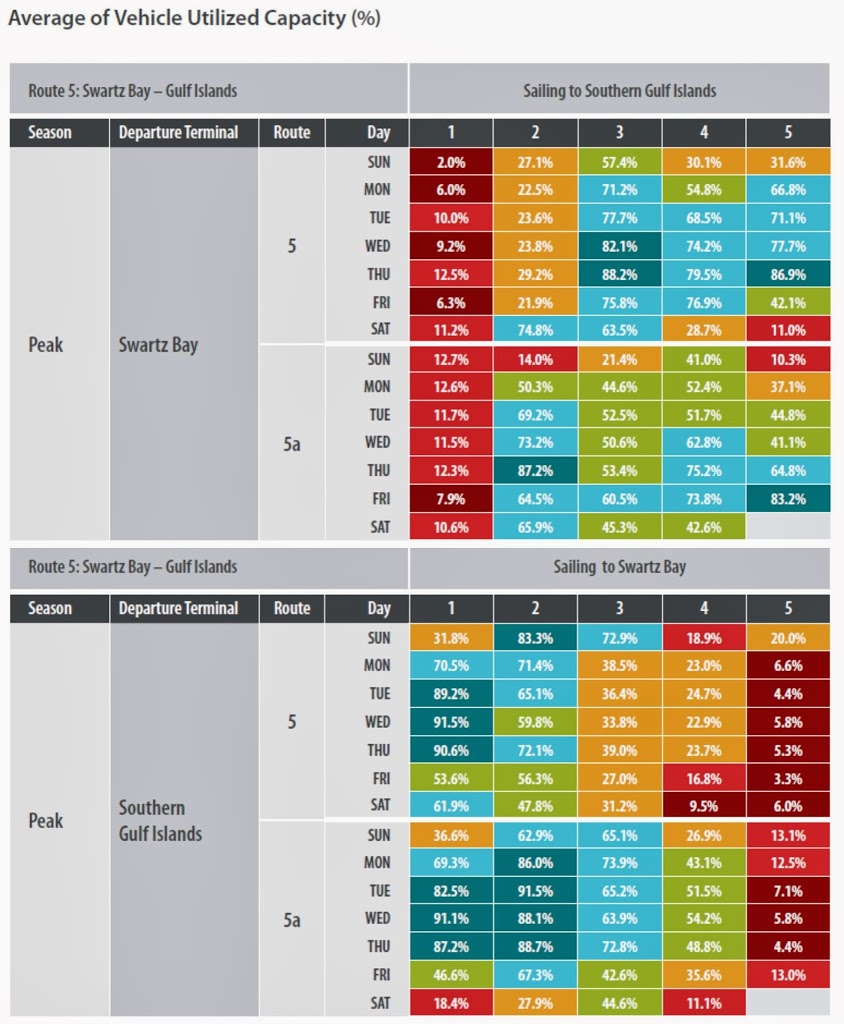 |
| Click to zoom in. Or go to the original source. |
See, the problem is the boat needs to return to Tsawwassen or Swartz Bay at the end of the day. They cannot be over-nighted at Saturna because the ferry crews don’t live on Saturna. Also, there are no re-fuelling facilities on Saturna, or all those little mechanical, restocking, overnight maintenance things that keep the ferries running.Economies of scale keep all of those things at Tsawwassen and Swartz Bay. This creates an interesting phenomenon. If you look (for example) at the Wednesday morning Route 5 sailing to the Gulf Islands, the utilization is an abhorrent 9.2% (yes, that is 6-9 cars, on average!), but the return trip on Wednesday Morning is 91.5% utilized. That second almost-full-on-average trip cannot happen unless that first virtually-empty trip happens. The same thing happens with the last run back to Swartz at the end of the day. It is virtually empty, but facilitates an almost-full last run to the Islands.
So complexities exist, and maybe that is why it appears the Southern Gulf Islands have escaped this round of cuts to service, and not because of the Premier’s property on Galiano Island.
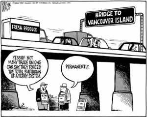
The local twitter-chat I got involved in last week was about another aspect of this report. Whenever anyone starts talking about BC Ferries and funding, a few futurist-engineers-in-waiting start talking about just building a bridge and getting the whole damn thing taken care of. Once and for all, build a bridge, charge a $20 toll, and problem solved. There are only two problems with this idea: a $20 toll won’t nearly cover it, and the technology required for such a bridge does not exist on planet Earth.
The BC Ministry of Transportation has a good summary of previous studies into the crossing, but if I can summarize the problems, it would fill a paragraph. The distance is too long. The shortest practical bridge would be something like 25 km long. This would not be the longest bridge in the world, but it would be more than twice the length of the Confederation bridge, and it would definitively be the longest bridge over very deep water. How deep? That is problem 2: the Strait of Georgia is more than 350 m deep, which is higher than the highest bridge piers ever constructed (and they are over land, with the deck only 2/3 of the way up!). The seabed at that depth isn’t even something you can build piers on, as there is another 400m or more of loose muddy sediments, in an earthquake zone. The depth of loose sediments (combined with the length) also makes a tunnel impossible. The best that could be hoped for is some sort of floating-foundation suspension bridge – one that would allow large ships to pass, could manage 5 meter waves, a 3 knot tidal current and 100km/h winds. No such technology exists, but it was estimated (in 1980s dollars, mind you) that such a technology could be developed and built for $8 Billion to $12 Billion, over something like 15 years. Financing it would require $200-$800 tolls, one way.
Oh, and this proposed bridge would essentially replace the two BC Ferries coastal routes that are making money, leaving most of the money-losing ones still running. So the Fixed Link is definitively not our short-term solution to Ferries costs.
That said, it might be a more rational approach to take a close look at some of the smaller islands and explore the business case for connecting them by smaller bridges to reduce the need for inter-island ferry services. I could get drummed off Saturna and banned from Mayne for suggesting this, but the aforementioned 20-km return side run by ferry could be alleviated by building about 5 km of connecting roads on relatively flat (and pristine) land and two small bridges to connect Saturna to Mayne Island. This would disrupt several people’s property (not the least the private owner of Samuel Island), and I need to emphasise that this would require a solid business case, not some random blogger’s speculation, but there may be opportunities like this to be found across the system.
I will go on in a later post about some of the actual proposals put on the table this week by the Minister of Kamloops, but for now, I have to call the NWimby-in-law and warn her about the torches and pitchforks headed her way.
*As an aside, I question whether “Utilization Rate” a good measure for the effectiveness of a transportation system. I wonder what the “Utilization Rate” of the Pattullo Bridge is, or the Massey Tunnel. What % of the time are they 100% full? An hour or two a day? But I digress.
I think your aside captures the heart of the problem best. What are the appropriate metrics to evaluate a transportation system? I it appropriate to use different measures on different components (roads vs. buses vs. ferries)? Some will need to be different, but how do you cross compare? And are the metrics we are using now driving unwanted behaviors or consequences?
The old Livable Region Strategic Plan had a goal to “help maintain regional livability and protect the environment in the face of anticipated growth,” and transportation objectives to support that. The only transportation objective I have seen from the province is to expand trade.