Earlier in the year, I brought this motion to Council, asking that the City be bolder in finding ways to re-level the balance between car use and other users for public space in the City. We had already made commitments in our Climate Action goals that we are going to change how road space is allocated in the City over the next decade. Then along came COVID to shine a brighter light on some of the inequities in our communities, and cities around the world started acting more aggressively on road space reallocation as a pandemic response. The time was right for New West to accelerate the ideas in our Master Transportation Plan.
Early on, there was some rapid work to address pedestrian and active transportation “pinch points”, especially in the Uptown and on a few Greenways. The city was able to quickly create more safe public space downtown by re-applying the weekend vehicle closure plan of Front Street that we already had experience with. Uptown, the BIA asked the City to allow temporary weekend-only opening of some street space for lightly-programmed public space. Response has been pretty positive: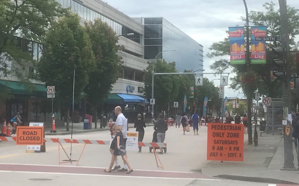
There is a bit of push-back on these interventions, as there always is when status quo is challenged in the transportation realm. Predictably, the traffic chaos, accidents, parking hassles and general mayhem that was predicted by more vocal opposition just didn’t occur. Staff is tracking actual data, but I have made a point to visit these areas often (COVID and working from home has made me into one of those walking-for-recreation types) and have been collecting admittedly anecdotal views of how these sites are working.
There are two more ideas that are being launched for the second half of the summer, and I want to talk about them because they came from different directions, but ended up in the same place, and are also eliciting some public comments right now (as was the intent!)
The City is piloting a “Cool Streets” program that identifies key pedestrian routes in the City for light interventions to reduce the through-traffic load and give pedestrians more space to stretch out. The way these streets were identified for the pilot is what makes this interesting, and speaks to one of my previous lives when I was briefly a GIS geek.
The goal to identify areas of the City where more vulnerable people have less access to green space, shade, and safe waling/rolling routes to parks and services. The approach very much aligns with the City’s Intelligent City initiative by using data-driven analysis to help make decisions. The City used its Geographic Information Systems (GIS) data set to identify areas that met the following criteria: higher population density, lower household incomes, larger proportion of seniors, and lower parks space per capita. Using GIS to “overlay” these layers, they identified area where many of these criteria overlap: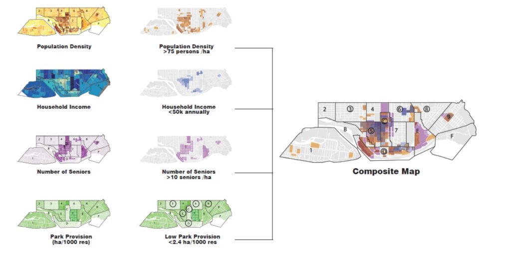
Once the “dense” areas of this map were identified, staff went through looking at the routes that combine connectivity to key destinations (parks and services), where grades were lower and where the most tree canopy cover was available:
They then identified priority routes for “green street” interventions (1, 2, and the west part of 3 in the map below), and extended these along streets that get to key destinations (the east part of 3 and 4):
The interventions here are very light. The roads are not “closed” to cars, but are calmed using ideas drawn from experiences in other cities from New York to Oakland to Toronto to Vancouver. The hope is to create truly traffic-calmed streets where local access by car is still available, but the space is open for people to share and program as they wish. Local streets acting like streets for locals, not as through-fares.
A second initiative was led by a community group in Sapperton. Concerned about some recent close calls on the part of the Central Valley Greenway that runs through lower Sapperton, they surveyed their neighbours and brought a proposal to staff asking if a pinching down of one block of the greenway could be trialed in light of the Streets for People motion. Again, the road is not closed, but signage was installed to discourage through-traffic and removable soft barriers installed.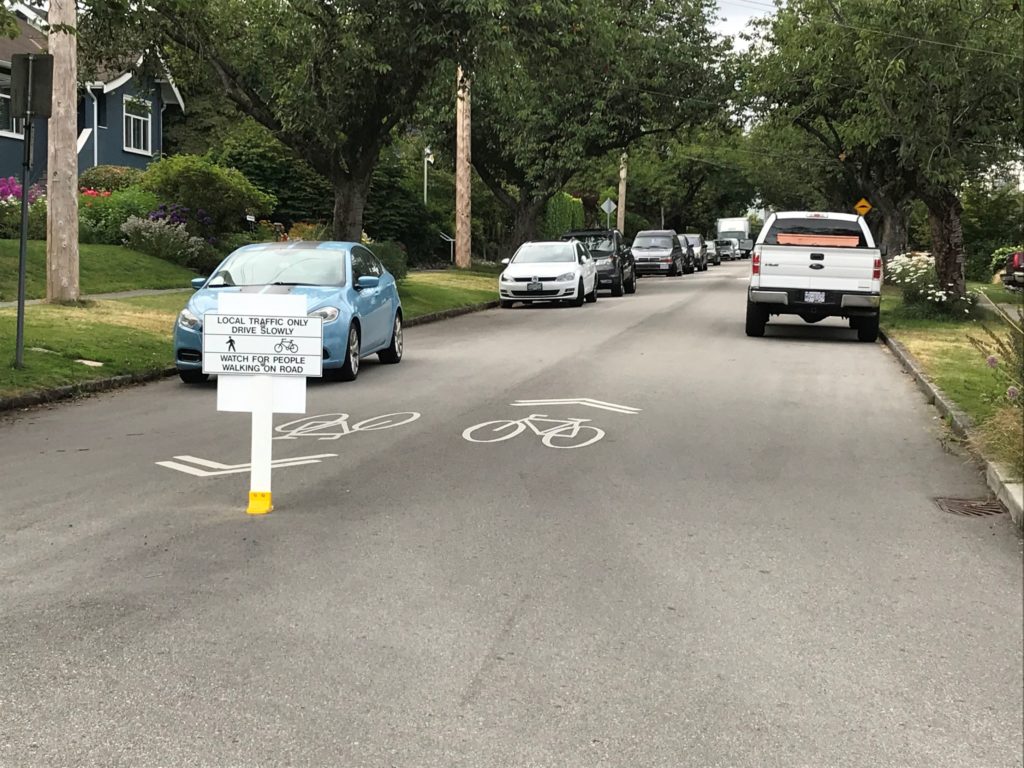
Both of these interventions are temporary pilots. They cost very little to put in action, and provide valuable data to our transportation planners, while also giving the public a chance to see what changes would look like before we invest in more permanent or expanded road re-allocation.
In her great book Street Fight, Jeannette Sadik-Khan talks about successes in urban residential areas where more local and lower-key interventions like this have occurred. A major part of this is trying some things (lightly, quickly, and cheaply) as a form of consultation and data collection. This allows us to get past the baked-in institutional resistance to change that says everyone has to agree on paper before we even try the most minor change, and before we can test whether a change is a net good. The Summer Streets program in New York was her model of this – feared by many, embraced by almost everyone once implemented, with the fears proving unfounded in the long term.
All that to say, these light interventions are designed to elicit not just public participation, but public feedback. And I have received feedback already. I’ve received e-mail form people very upset that they were not consulted; e-mail form people predicting traffic chaos; and e-mail from people asking if they can do this on their street. My short answer to those questions are, respectively: this is the consultation; the sites selected were local streets, not traffic-challenged throughfares, but staff will be collecting data to assess the impacts on traffic; and not likely this year just because of timing, but if things go well, I hope these kinds of pilots can be expanded in 2021.
So, if you like this kind of intervention, let us know. If you don’t, tell us why. Staff have included in the analysis above other priority areas for Cool Streets that may be implemented in the future, including Downtown and the McBride commercial area in Glenbrooke North. As for the community-driven version, if you would like to see this type of intervention as a temporary or permanent feature of your street, start reaching out to your neighbors (maybe hold a social distance block party?) and talk about it. If you can gather enough interest, maybe the City can make something happen in 2021. To me, local communities reclaiming space is a major part of making Streets for People again.
How about incredibly hot streets? Making heavy trucks fight gravity all the way through Sapperton to the top of Royal Avenue. Truck traffic is not light on weekends through New Westminster!
Where is the logic and good sense environmentally speaking in this front street closure? The air quality and noise is much worse for everyone.
Patrick – that street in Sapperton is my neighborhood and those folks are such a great community. Perhaps a good silver lining to this pandemic is getting our streets back from those air choking cars. Now if someone could just do something about the Pepsi truck driver that slams his giant gate shut every morning at 2AM. Thanks for your always informative blog.
Obviously you haven’t been on Columbia Street downtown on the weekends since they closed Front Street. Traffic jam all weekend. So definitely still as you say air choking cars. Stupid idea.