This is an issue that bubbled a bit during the last election. Most notably, Council Candidate Vladimir Krasnogor raised the issue of heavy truck traffic on Royal Avenue throughout the campaign. The issue didn’t seem to have legs, though.
I used to live on Royal Ave and 10th: a great condo in a great building. Our first experience with Condo ownership was a surprising success, mostly because the Strata Council was proactive, with a few very sharp members who were able to manage the books and keep the ship running. The only downside of the place was intersection of Royal and 10th. The pavement was pretty beaten up, with a huge volume of heavy trucks causing the asphalt to ripple dramatically. Although the route is only a “daytime” truck route, it only takes a few scofflaw drivers to give people the impression it is a 24-hour truck route. Laden trucks grinding up Royal between 10th and 8th were bad enough, but the crash bang of (seemingly empty) container trucks rattling over the rippled pavement while racing through the intersection on the downhill route can shake you filings out, and that one-in-a-hundred jake-brake user during a quiet summer night paints all drivers with a bad brush, even from 20 stories up.
I sympathized with the folks at City Hall even when I was phoning to complain, yet again, about the guy in the Celeste green wood chip truck with the wailing brakes who drove down the hill, wailing away, yet again, at 5:00am. The City Bylaw Officers did what they could with enforcement, but it was an endless game of whack-a-mole.
What are you going to do? Trucks are necessary for the operation of our society. Royal is on the Major Road Network, and therefore Metro provides money to maintain it, and they are not likely to remove this route from the MRN unless viable alternatives are provided. I hear people at the Master Transportation Plan open houses talking about how “cut and cover” is the solution to all truck traffic issues, without acknowledging the costs and other logistical issues (not to mention the tradeoffs) that come with those types of hard, expensive, engineered solutions in urban areas.
This intractable issue has come up again, as part of the discussions around the Pattullo Bridge. Like many lightly-scabbed-over intractable problems, an off-hand comment from Matt Laird peeled it open again, and got me thinking about the problem in a different way. While looking at the various off-ramp designs TransLink had offered us for their new Bridge, Matt asked why trucks had to turn right onto Royal from the bridge. I’m not sure anyone in the room got what he was talking about, but for the last couple of weeks, that question has been stuck in my head like the baseline of “The Lion Sleeps Tonight”. There. Now it’s in your head too.
So I got thinking about the question, and came up with this handy little diagram.
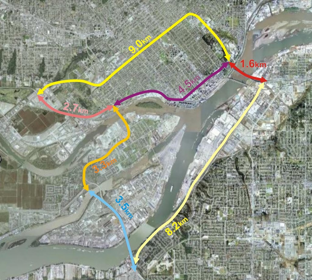
This measures the distance between key points relating to truck movements around Royal Avenue. I’m assuming that the South Fraser Perimeter Road will be completed and the Pattullo Bridge (in whatever shape or format) will continue to connect to East Columbia and Royal near McBride. The numbers indicate the distances between the important node points. So the distance from 124th and King George in Surrey (the intersection of the SFPR and Highway 99A) to the north foot of the Queensborough Bridge via Royal is 1.6km + 4.5km, or 6.1km.
So let’s look at what options truck drivers have while crossing the Pattullo Bridge (for the time being, lets ignore the trucks that have specific business in New Westminster, and talk about the through-traffic only).
Arriving at the Hwy99A/SFPR intersection from any direction, any truck heading to the TriCities is pretty likely to take the Pattullo, as the asshats at MOTI have decided not to connect the two most expensive road-building projects in the Province (Port Mann 2 Hwy 1 and the SFPR) with an intersection where they cross. These trucks will therefore be forced to cross the Pattullo, take East Columbia, and get mired in the Brunette / Braid intersection and Brunette overpass hijinks. (note, the UBE would definitively NOT have solved this problem, as the trucks want to get to the 8-lane Lougheed or the 10-lane freeway, not to a driveway-laden 4-lane service road through big box retail and casino entertainment hell)
Trucks heading to the northwest will typically stay on 99A up McBride. The only trucks taking Royal would be those heading west to the Queensborough Bridge intersection: the aforementioned 6.1km trip. If their destination is along Marine to points west, the logical alternative is to continue up McBride to 10th, then go down Southridge Drive to Marine at Byrne Road: a trip of 10.6km, which is only slightly longer than the Royal route (which is 8.9 km total). If their destination is the East-West Connector, then their option is the SFPR – Alex Fraser route, which is 11.7km compared to 9.4km along Royal. Considering the SFPR route will all be separated freeway, and not involve stop-and-go traffic lights, even most destinations in Queensborough might be better serviced from the southern route.
Now what about trucks coming from the E-W Connector? The only reason for them to use the Pattullo is to access the TriCities if they choose the longer Alex Fraser – SFPR – Pattullo route, which is quite a bit longer (13.3km) than the Stewardson – Columbia route (7.8km), so not likely. More importantly, if their destination is south of the River, they might be best off to cross the Alex Fraser right away, as they will get to Surrey sooner (11.7km of freeway vs. 9.4km of City streets), so no Pattullo access needed at Royal.
Coming from Marine Drive, the only reason for trucks to use the Royal-Pattullo route is to get to Surrey, and Royal is only one of the three options (Royal is 8.9km, 10th and McBride is 10.6km, and Queesnborough is 17.7km).
So again, except for local traffic, why do trucks need to be able to access Royal from the new Pattullo? Is a 10% longer route along less-restricted roads faster than a shorter route with hills, stoplights and commuters?
I guess one point to take out of this is that we need to understand the ultimate routing of these trucks, in order to service them adequately, not just whether a truck is “local” or not. If only 5% of the trucks are using Royal Avenue because it is a significantly better routing than any alternative, but because of that 5%, we build Royal into the quickest route, then that will attract trucks off of the alternative routes that are only slightly longer. We also have to ask the hard question: is accommodating those 5% of trucks worth the cost to the livability of our City?
These questions require better data to answer. As does the “local truck question”: are there better alternatives to service the trucks whose destination is New Westminster, separate from the through-traffic? Remember, “truck routes” only apply to through traffic (trucks with local business are not limited to these routes, but can use service roads to access businesses that are not on truck routes).
Maybe Matt and Vladimir are right – maybe it is time to start talking about taking Royal off of the MRN. Could such a move be timed to coincide with the opening of the SFPR? Would such a move put the Pattullo replacement project into a new light?
I am rather discouraged that the City does not appear to have this data. To me, knowing exactly where trucks need to go is REQUIRED to be able to plan their routes!
What does it take to take a road OUT of the MRN? I was looking at the MRN map the other day, it’s got some strange and unexpected holes in it…and the truck routes don’t overlap with it either. Not sure I understand how these two maps are supposed to work together…