Connecting QB to the Quay

Amongst the great legendary structures of New Westminster, none has seen as much rumour and speculation as the mythical Bridge to Queensborough.

Not the Queensborough Bridge, but the allegedly announced, apparently planned for, and suspiciously funded but not-quite-yet-built fixed pedestrian crossing from the Quayside boardwalk to the east tip of Lulu Island, where the burgeoning neighbourhood of Port Royal is remaking the shape of Queensborough.

The reality of the bridge is that it is, indeed, “planned”. There is even a bit of money set aside for it. Any time I raise the issue with anyone at the City they assure me it will definitively be built. It is next on the list for DAC projects, done by 2016. Or 2017. Or 2019.

Now, for most people, a fixed piece of transportation infrastructure between the Quay an Queensborough seems like a great idea- who could be against it? It is like being against the Quayside Boardwalk, or the Central Valley Greenway, or the Seawall. The only people seemingly against it are those few familiar names who are against everything the City does. In a curious game of whack-a-mole problem-finding, they raised various complaints: it was too costly; it was an eyesore; it would destroy the “Submarine Park”.

These complaints were based on an early, and very preliminary, engineering assessment done on potential crossing options. This original plan was what you get when you give engineering consultants as free reign to build a bridge: it is big, expensive, and does the trick. A good starting point, but hardly the best of all possible solutions.

The reason we are even entertaining this idea to build a pedestrian bridge to Queensborough is due to DAC funding. The bridge is one of several identified projects that rose out of a slick deal cut between the City and the Provincial Government related to the old Riverboat Casino (which morphed onto the Starlight Casino). The background is complicated, but when the Province wanted to change the funding model for Casinos, New Westminster asked to be compensated for loss of potential income, and the Province agreed, but the money had to be earmarked for specific projects (could not be put into things like general revenue, or operating a ferry service, or paving Daniel Fontaine’s back alley). Amongst the earmarked projects were the newly-completed Queensborough Community Centre upgrades, other park amenities in Queensborough, and the Anvil Centre. Long version short, the City has a small pile of money from the Province they need to spend on building a pedestrian link to Queensborough.

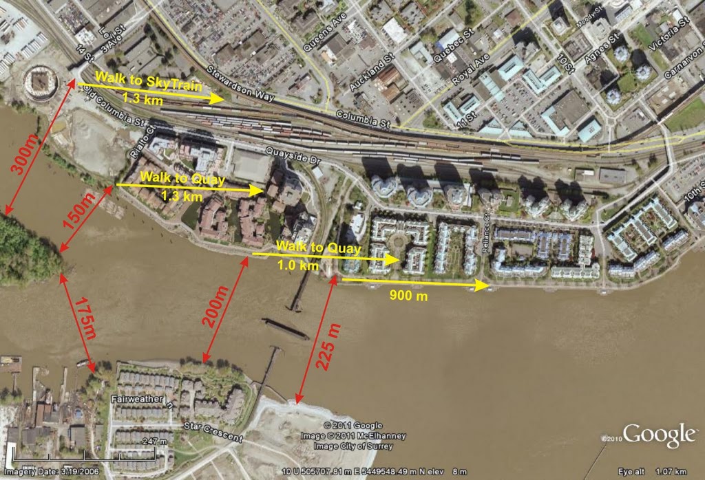
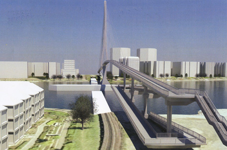
This led to the 2009 report which provided early design ideas (including the drawing above), and led to a significant amount of whinging from the Quayside residents (although there is a general ambivalence about the project displayed in the Quayside Community Board minutes from 2009 when the project was announced).

That is not to say the original bridge plan was not without problems. The projected cost was much greater than the DAC funding available. A fixed crossing would need to be 22m above the water (~20m above the landings) due to requirements for maintaining a navigable channel for river traffic, which would potentially make for ungainly ramps of something like 400m length to accommodate pedestrians, wheelchairs, bikes, etc. Apparently, the Railway was not so chuffed about the idea of the City driving piles to support a 20-m-high bridge next to their 100-year-old pilings. The original landing spot for those ramps was where the current “Expo Submarine” park is located. Finally, the eyesore issue that if the City built the cheapest bridge possible, it was going to be ugly, and if they went for the grander vision, it might not be a vision shared by everyone (grandeur-wise, and cost-wise).

There were some creative alternatives floated. A ferry service, or a gondola. Maybe I will cover those in a future post, but extremely short version: show me the business case.

So it was exciting a couple of weeks ago when the City announced a new set of plans developed in partnership with the owners of the railway bridge: Southern Railway. The big difference this time around is the low elevation of the bridge, which makes life much easier to pedestrians and cyclists, but means the bridge must swing or draw to allow marine traffic to pass. A City Councillor I was chatting with last week even suggested it could be built to accommodate an ambulance for emergency use.

The problem? Who is going to open and close the bridge? The current train swing bridge stays “open” to marine traffic and is swung closed only when a train needs to pass. This would make a pedestrian crossing pretty much useless, so there is discussion of making the default “closed” to marine traffic, opened only when a boat has top pass. The Port would need to agree, as would the owners of the rail bridge. And someone would have to be on staff to flip the switch.
These are not minor details. SRY currently staffs the swing bridge and the one that connects Queensborough to Annacis Island adjacent to Derwent Way. That second bridge has the default position of “closed”, but that is just a minor channel approachable from both ends, not the entire North Arm of the Fraser River. If the City will be required to staff, or compensate SRY for the staffing, of a swing bridge, then the economics of this “less expensive” option may go away fairly quick.
Ultimately, I only hope the crossing will be reliable – one you can count on being there when you need it, and not unexpectedly opened for a hour at random times – because I see this bridge primarily as a transportation link, not a tourist draw or a nice place for a walk on the weekend (although it will be both of those, if done well!). Then it will be the link we have been missing up to now. 

Shoreline Cleanup – a good news story.

I noticed this blog has been full of bummers and whinging lately (“lately?”), so I wanted to give a shout-out to a good news story here in New West.

The Great Canadian Shoreline Cleanup is an annual nation-wide event, where various volunteer groups adopt a stretch of shoreline near their homes and (as the name suggests) clean them up. There have been off-and-on shoreline cleanups in New West, mostly organized by Scouts or Businesses, but last year was the first NWEP-sponsored “public” clean-up. You didn’t need to belong to a club or a business, or even the NWEP:  it was just a drop-in on a Saturday. It was organized with remarkable fervour by NWEP member Karla Olson.

The stretch of shoreline chosen for cleanup was the recently-refurbished stretch of South Dyke Road between the Boundary Road and Derwent Way, in sunny Queensborough. The stretch of shore has a combination of multi-use paths, dock features, and walking trails that make the most of the waterfront, so keeping it clean seemed like a great community-building idea for the relatively new neighbourhoods in southern Queensborough.

Last year, there was a bit of a panic, as it seemed there wasn’t really all that much trash – so Karla was a little concerned her volunteers would make the effort to show up, and have little to do – so she added a small invasive plant pull at the same time. A patch of Japanese Knotweed was crowding out native plantings by one of seating areas, and a patch of English Ivy was threatening to choke out a Douglas Fir right on the waterfront. With some help from the City on New Westminster and a volunteer expert on invasive plant management (who happens to be married to the new Royal City Farmers Market Operations Manager), a plant pull and disposal was organized.

Turns out, litter is the kind of thing that surprises you once you start collecting it. Karla’s fear (optimism? ) was unrealized and the volunteers who showed up collected an ample amount of trash. They also took a real bite out of the Japanese Knotweed patch and the English Ivy climbing the tree. Karla’s organization skills came to the fore, the 30-odd volunteers had a great time, and made a difference in the local community.

This year, the Shoreline Cleanup is back for more on September 23rd. With more people using the waterfront trails, and lots of jetsam brought to shore by the high freshet this spring, the (now annual) event will probably see more trash this year than last. They are also hoping to see more volunteers as well – which is why the “Invasive Plant Pull” part of the program is expanded this year.

If you haven’t been involved in a plant pull before, here is the quick background. There are several species of plants considered “invasive” in BC- not just because they come from other continents, but because they are safe from their natural emnemies (predators, insects, weather) and without these controls, they can take off – even displacing the native plants and threaten the native habitats of plants, bugs, birds and other animals. Most are bought as ornamental plants, and go “feral” when someone throws yardwaste or plant pots into the woods – to “give the plants their freedom”.

A “Feral Potted Plant” found on South Syke Road during plant tagging.

During last week’s invasive tagging event, we found lots of morning glory , some wrapping itself around and choking out native snowberry plantings; a couple of Scotch Broom plants; resdiual English Ivy from last year’s pull; and English Holly, which is merry at Christmas, but invasive in the wild, displacing the similar but native Oregon Grape. All of these will be targeted during the plant pull part ofthe Shoreline Cleanup.

The Japanese Knotweed that was knocked back last year has started to come back, but now that it its weakened, the City can come back and do stem injection to kill off the remainders, before the roots undermine the dike. And then there is the Himalayan Blackberry, a nasty (but tasty!) invasive that has become so ubiquitous, that eradication seems a distant dream. It is also a mean, spikey plant that is probably best managed by people wearing thick clothing and safety glasses.

So if you want to help out for an hour or two, you can collect trash, or you can get a little bit more involved taking out some invasive plants – you might even learn a bit about what plants are native and which are invasive – once you can identify a few species, you start seeing them in other places. Most importantly, you can meet some people in the community interested in protecting the shoreline, and be part of a nation-wide campaign.

No pressure, no long-term commitment, just a family-friendly day helping out in the community.

It’s best if you sign up ahead of time, by clicking here. you can also just show up, but if you bring the kids or are under 19 yourself, you need a waiver signed by a Parent or Guardian, which you might want to get done ahead of time (you can get the waiver on the website, and bring it with you).

The shoreline is muddy at low tide, so you might want to wear boots or rugged footwear. Long sleeves and pants are a good idea for pulling invasives and for picking up trash (the City of New West will provide gloves for voulunteers – but you can bring your own), and there will be a few tools available, but feel free to bring your own clippers, loppers, garbage pickers, etc. Bring some water and snacks, as the event will probably go on for a couple of hours – just remember to pack out your wrappers!

The Event is on September 23 , starting at 9:30 AM. Folks will meet on South Dyke Road, near where Suzuki Street meets it – you should see the tents there, a couple of blocks east of Boundary Road, as far south-west in New Westminster as you can be!

Poplar Island, and a bridge to elsewhere.

It is the biggest stand of trees in New Westminster, and you have probably never been there.

Poplar Island has a rich history, which you can read about in some detail here. For those with stunted attention spans, it has been a rancherie, an Indian Reserve, a smallpox hospital (prison?), a shipbuilding centre, a home, and for most of the last 50 years, little more than a convenient place to boom logs. The history of ownership is about as chequered, and perhaps even a bit uncertain now…

I raise this issue now because some people have suggested that a bridge to Poplar may be a good idea, as part of the project to connect Queensborough’s perimeter trail system to the Boardwalk and Quayside, and finally provide a real community connection to Queensborough residents.

The problem is, attaching Poplar to this idea is a recipe for all kinds of troubles.

First off, that legacy of Poplar creates all sorts of legal issues around connecting to it. With a 100-year history of industrial activity, there is a clear history of Schedule 2 activities, so re-zoning it for Park would be somewhat complicated, even if there is not contamination present (actually, the logistics involved in doing the sampling required to determine if it is contaminated would be a real hassle for an island with no roads, no landing docks, and no services). Then if somehow the City got the rights to use the Island, and negotiated fair use with the appropriate First Nations, and got the contamination situation figured out, how do we go about controlling access to the park, preventing fires, stopping squatters, etc. I suspect there is a reason the island is being preserved in a relatively natural (if second- or third-growth) state…

I hate to be a Debbie downer. I think that a well-designed park, accessible and safe, with a proper emphasis on displaying the important heritage of Poplar, would be great benefit to the City, but it will take a long time and a fair pile of money to develop. Maybe in my second term as Mayor. So the risk here is a measured response to reclaiming Poplar Island will slow down the bridge project, potentially for decades.

Worse actually, is that Poplar Island does not represent a good place to put a bridge, if your goal is to connect the burgeoning communities of eastern Queensborough and their integrated greenways with the Boardwalk, the Quay, Skytrain, and the rest of downtown.
If we want to build a pleasant park trail to be used occasionally for dog walks, then let’s wait until we can get Poplar worked out and build the bridge then. If we want a piece of sustainable transportation infrastructure to connect Port Royal and the rest of Queensborough to the rest of the City, let’s at least put the bridge in a useful spot. That means ignoring Poplar for now.

(Click to make big enough to be readable. Hey Google Earth, your share of my profits are in the mail)

As you can see in the above diagram, connecting just west of the train bridge to the trail just east of the little beach on Queensborough would require a bridge about 200m long (measuring between imaginary pillars set on opposite banks). The controversial “Submarine Park” location, more like 225m. Access via Poplar will require two bridges, totalling 325m at the closest points, of 475m to connect to the Third Ave overpass as was suggested by come commentors.

I recognize there is more to a bridge’s cost than a simple length calculation, but as a first approximation, isn’t it safe to suggest a shorter bridge is likely to be cheaper?

The second half of bridge location is that it connects to. As attractive as hooking into the Third Ave overpass may be aesthetically, I don’t think pedestrians from Queensborough are not all that interested in better access to Key West Ford (although I am sure their vehicle deals are second to none). They want to get to the Quay, to the Skytrain, and to Downtown New West and the new MUCF. So why take them so far away from their destination?

I think the Submarine Park is a minor issue, compared to building a bridge that acceptable to the local community from an aesthetics viewpoint, is accessible by more people, and serves its purpose as an important peice of sustainable transportation infrastructure.

The Submarine doesn’t have to move, and in the slim chance it has to, there are other locations it can go. At the Quayside Sale/Festival, I overheard Councillor Harper talking about the bridge with a concerned citizen, and addressing concerns that the “Submarine Park” was going to be removed. He said: “do you really think this Council is going to vote to remove a park?” The question may have been rhetorical, but it seemed to stump the questioner…