Plans and Promises

I have had interesting interactions on social and traditional media this week, and it got me thinking about plans the City makes, and where those interact with promises made by politicians. I am new to making the latter, have made the former for a long time, but haven’t really thought about the differences. let me see if I can tie this together into a cogent discussion.

It started with this Facebook post:

Hey Patrick, Earlier this year you spoke of the pedestrian and cycle improvements that were soon to be built along Braid. What does soon mean? You spoke of right away, seems you’ve become just another politician, promises promises…….

I have a slightly vague memory of having this conversation, as it was around the time some public consultation was being planned around this project. I knew the project was coming along because we talked about it at ACTBiPed, and because I attended an event as Acting Mayor just before the last Federal election where an MP from and adjacent riding announced some federal funding to help fund the project.

So I replied to the Facebook post with a link to the project page (above), and slightly cheekily followed with “no promises, though”, because it seemed to me the poke about “promises” by my inquisitor was slightly tongue-in-cheek. Or maybe not, as another person took slight offence to my flippant attitude, requiring yet another response by me that provided more detail, proving once again that Social Media is a terrible place to infer nuance.

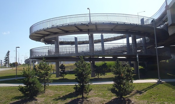
The longer version of my response is that the project is coming along, but this isn’t really something I would think of as a “political promise”. I don’t think anyone ran for Council supporting or opposing a plan to put green separated lanes on the north side of Braid Street to connect to the United Boulevard bikeway. However, some of us were more supportive than others of the Master Transportation Plan for the City adopted just before the election (I don’t think anyone NOT supportive of it was elected). I am not only still supportive of it, but am supportive of rapidly implementing the active transportation measures included in that plan, including filling some of the important gaps in our bicycling network.

When it comes to building certain connections, though, that is really a complicated discussion between Council, staff, our Advisory Committees and other stakeholders, and is influenced by the capital budget and various priorities. This particular project was seen as a good chance for some senior government grants (applied for and won), represented an important gap, and was generally seen as ready to go. Drawings were created, some cost estimates done along with some public and stakeholder consultation. Capital budget was set aside in the 2017 year to do the works. My “supporting” this plan was a very minor part of the plan coming together for 2017, even as one of the members of a seven person Council.

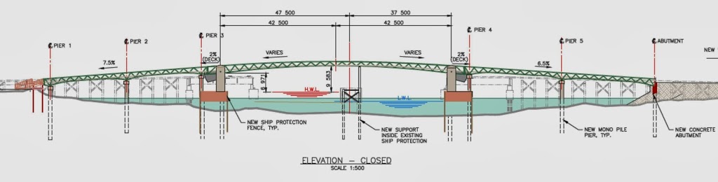
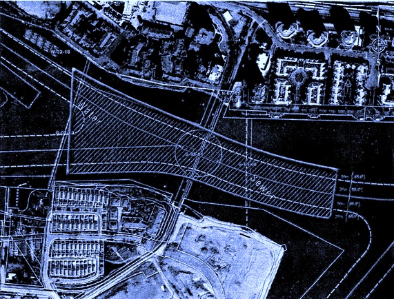
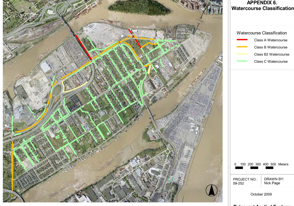
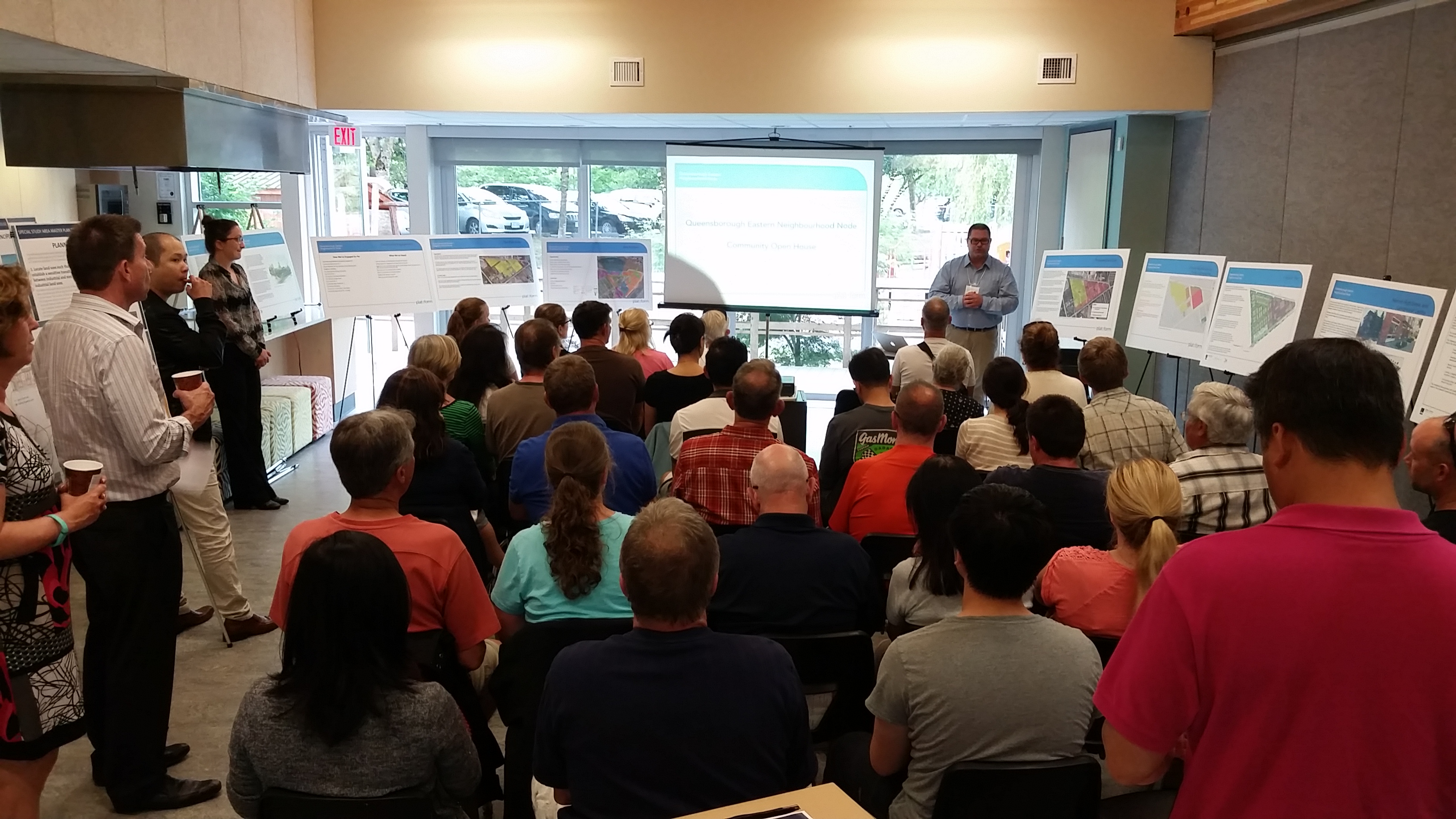
That said, I can see a couple of potential issues that may prevent this from happening on the existing timeline. If you look at the poster boards from the Public Consultation, you will note that the map has red lines on it. Those are property lines, and a large part of the project is within rail property. I understand that we have agreements for these properties, but as we are learning with whistle cessation measures elsewhere in the City, the way rules and agreements work on rail lines is not always straight-forward, and it is best not to be too hasty predicting how those agreements will work out when it comes time to roll out the excavator. The second issue is, of course, the upcoming Brunette Interchange project by the Ministry of Transportation. I can’t tell you too much about it because MoT has not yet released their project drawings, but if there are changes in how Braid Street works through this area, we may need to go back to the drawing board. I don’t know the answers to the questions, nor are they completely in Council’s control.

I have every reason to expect this project will proceed in 2017 as planned, but all plans are subject to change, based on the rule of best laid plans. This doesn’t mean we won’t build a safe cycling and pedestrian route between Braid and the Bailey Bridge, it just means that the connection may not arrive exactly as we envision it today, or on that timeline. We’ll stick to the goals, we may need to change the plan. Stay tuned.

As for “promises”, I remember promising to support the Master Transportation Plan, to support and work towards implementation of the transit, pedestrian, and bike infrastructure improvements in that plan, I promised that stakeholders like HUB and the members of ACTBiPed would be involved more in planning these types of projects. I also promised I would do everything I can to be the most open Councillor about talking about how decisions around the Council table are made – mostly through this blog and other Social Media, hoping that openness would build more trust in the work City Hall is doing. If we make a decision you don’t agree with, I hope you will at least understand my motivation for making that decision, and hopefully you will be angry at me for the right reasons.

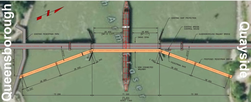
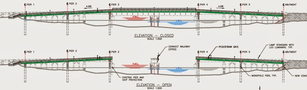
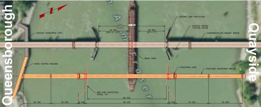
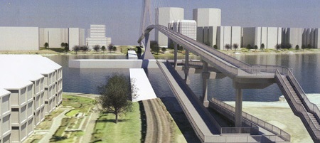
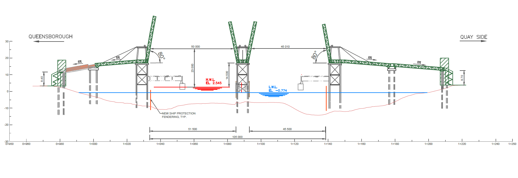
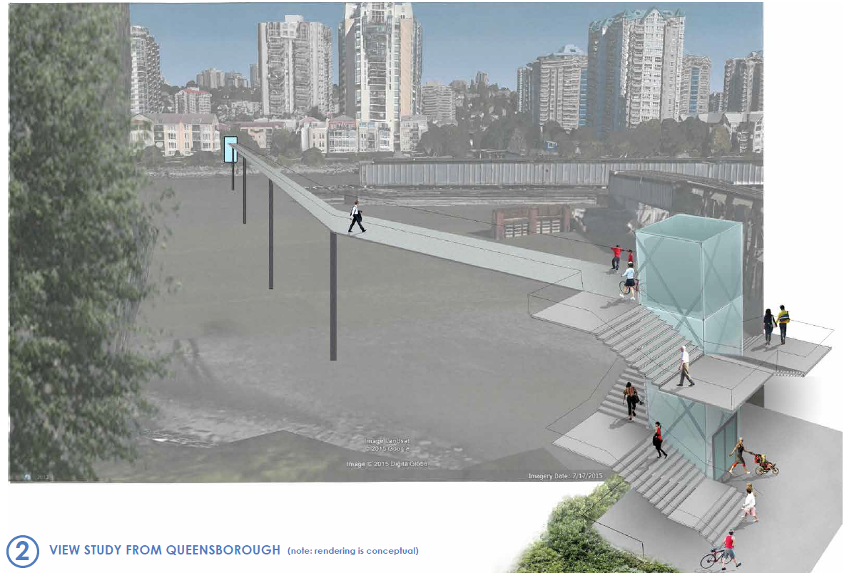
Which brings us to this week’s editorial in the Record, where they are critical of Council’s approach to the Q2Q bridge. They are right that the current situation is a let-down, and that, ultimately, Council has to own that disappointment. I may (cheekily) offer surprise that they claim to have known all along it was impossible to build the bridge, and didn’t bother to point that out to anyone, even when previous engineering reports suggested it was well within scale of our budget, but that is not the part of the editorial that made me retort. Instead, I was pretty much with their argument until this:

It doesn’t take a political scientist to figure out that Queensborough’s project would be low on the priority list. In fact, you just have to drive down Ewen Avenue to know that Queensborough often gets the short end of the stick.

I have to respectfully disagree with the suggestion that this Council ignores Queensborough as some sort of political calculation. That the Editor used Ewen Avenue as an example suggests to me they have not been to Queensborough in some time. Ewen Avenue is undergoing the single largest road improvement project in New Westminster in the last decade. Two years into a three-year $29 Million upgrade, the entire length of Ewen Avenue is going to be a brand new transportation spine for all modes. It has been a big, disruptive construction project, but the end result is becoming visible now, and will change how Ewen Avenue connects the community in a pretty great way.

If the issue is priorities, the Editor may be reminded that the Q2Q plan was part of a series of DAC-funded projects that started with $6.2 Million towards the $7.7 Million renovation of the Queensborough Community Centre, including the opening of the City’s first remote library. It included another $5 Million in Park and greenway improvements for Queensborough (including the South Dyke Road Walkway, Boundary Road Greenway, Sukh Sagar and Queensborough Neighbourhood Parks, and a pretty kick-ass all-wheel park). These were the first thing done with DAC funds, not a low priority.

Just two weeks ago at Council, we turned down capital funding support for a Child Care facility in Uptown because we placed the need in Queensborough as higher priority, and dedicated our limited child care funds toward filling that need. That isn’t “the short end of the stick”, that is including Queensborough’s needs along with the other neighbourhoods of the City when directing limited resources towards where the need is greatest. This council has a record of fighting (and winning!) to keep Queensborough in the same federal riding as the mainland, and a record of fighting (and losing) to keep it in the same provincial riding. Queensborough has never been an afterthought at the Council table during my time there, but a neighbourhood we continue to invest in and be proud of.

The situation for Q2Q sucks, there is no way to dress that up or say it more elegantly. A set of projects was conceived a decade ago, and of them, this project does not appear workable in the current form. The work is ongoing right now to determine how the remaining DAC funds can best be used connecting Queensborough to the mainland, and I am hoping a new and viable plan will come along soon. Call the current set-back a broken promise if you must, but the decision to not move ahead with a $40 Million option right now is not proof of a City disregarding one neighbourhood, it is a matter of understanding our fiscal limits as a City of 70,000 people with dreams perhaps bigger than our reality.

The Q2Q quandary

No doubt the biggest let-down last Council meeting, indeed the biggest disappointment of my time on Council, was the releasing of the updated projected cost numbers for the Q2Q bridge preferred concept.

A short version of this project is that the City will receive “DAC” funding from casino revenues to spend on a fixed pedestrian link between the Quayside and Queensborough, based on a 2007 agreement between the City and the Province. Based on some very preliminary cost estimating, the project was put in the $10 Million range, so Council placed that amount in the budget to support the project. The idea has seen several rounds of public consultation, with several design concepts sketched out and debated. Ultimately, a design that would be acceptable to the regulatory authority that controls river crossings (i.e. a design that allows safe and unfettered barge traffic) and still allows reliable pedestrian use was developed to the point of doing detailed cost estimating. That cost came back at a little over $39 Million. The City doesn’t have $39 Million, and it is hard, with so many competing capital priorities, to see how we can get $39 Million to make this project work. I’m frustrated and disappointed.

However, regular readers (Hi Mom!) know I rarely stick with the short version, so I thought I would go into a bit more detail about how we got here, and where we may go from here, because I want to slay some of the social-media-derived myths about the project.

This project was not killed by NIMBYs. Over the last 10 years or so, the Q2Q project has gone through several iterations. The DAC agreement was in 2007, but it was always anticipated that the Queensborough Community Centre update, other park improvements in Q’Boro, and the MUCF (now called Anvil Centre) would be the completed before the Q2Q project began. The DAC funding did not arrive as one big cheque in 2007, but is allocated as projects come along, and as casino revenues come in. Q2Q was a little further down the timeline.

During those 10 years, preliminary planning work was done on a few concepts for a “fixed link”. At several times, early concepts with very preliminary sketches were bounced off of Quayside and Queensborough residents. For lack of a better term, these concepts were “focus grouped” to test public reaction and determine what potential concerns residents on either side and other important stakeholders may have. They were also run past pedestrians and cycling advocates (like me) to see if their needs were being met.

Three different “high level” crossings were evaluated about 8 years ago. These would completely span the navigable channel at a height that met regulatory requirements (and therefore be about the same height as the Queensborough Bridge). There were some concerned neighbours about the mass of the structure, and some were concerned about the fate of the “Submarine Park”, but there were also some functional and cost concerns with this early concept.

Cable stayed bridge Option 1, estimated cost $19 million.

At the advice of the Council of the time, staff stepped back a bit to take a look at options that didn’t go so high as to span the navigation channel, and would require a lift, swing, or bascule section to open and allow boat passage. This opened up a large number of potential options, including new alignments. For a variety of technical reasons, a bascule was determined to be the best option for a lightweight span with a limited footprint. This evolved, through a type of value engineering, into a couple of models of twin bascules – one at a moderate height (but requiring elevators to be accessible) and one at a low enough height that grades were accessible (but requiring more opening/closing cycles, due to reduced boat clearance).

These also saw some limited public consultation, and some neighbours expressed some concerns about the location of one of the “elevator” options. However, Council felt we had enough information to do a more detailed cost analysis of the most practical alternative. That alternative is the one that came back to Council with the $39 Million price tag. The concerns of neighbours were part of the considerations, but the $39 Million was the deciding factor.

Cost estimates are necessarily iterative.
Someone asked me how this project ballooned from $6 million to $39 Million? The simple answer is it didn’t.

The original DAC funding formula envisioned a ~$10.5 Million crossing. I can’t speak to how that number was arrived at (I wasn’t even a local blogger in 2007!) but I can guess it was a simple bit of math: pedestrian bridge, 200m span, look at a couple of recent examples around the country, don’t worry too much about details (the City can always make up a shortfall if needed from their capital budget), and since we aren’t building it for another decade, any estimate we make now is likely to be off anyway. The point wasn’t to plan a bridge at that time, but to earmark parts of this one-time funding source towards worthy projects.

The City then went to work on some of the other DAC projects: the Anvil Centre, the Queensborough Community Centre, and other waterfront improvements in Queensborough. To better make the financing work without having to enter too much long-term debt, they re-allocated some funding between DAC project areas. Consequently, the DAC funds for the Q2Q are now only a little over $6 Million, but another $5 Million in capital reserve funds was earmarked to cover the difference, meaning we still have the ~$11 Million originally earmarked.

As far back as 2009, order-of-magnitude cost estimates for the high-level crossing were in the $15 – $22 Million range. This is when the City went back to the drawing board to see if there were more affordable options, and also started to look around for sponsorship and senior government grant opportunities to see how much of a funding gap could be filled. By 2013, preliminary estimates for the first bascule concept were given as cost of $10.4 Million.

Fast forward to 2016, after Council asked staff to spend a little money on getting some detailed cost estimates on the more refined design, where $11 to $15 Million was still the general thinking, as we became aware of some of the significant engineering challenges. These included the need to install pillars in the river (not just on shore), the barge collision at Queensborough back in 2011 which definitely triggered a closer look at the safety factor for large vessels through the north arm, and the mechanical and operator costs for a bascule bridge. It seemed likely these would offset cost savings that might be realized by not going 22m high and building 1km of ramps. Add a few shifting project priorities as the public consultation and interest in the project increase (Strong enough to carry an ambulance? Wider than 2m for greater pedestrian comfort? Offset to reduce impact on vulnerable riparian habitat on the Q’Boro side?) and things start to add up.

That said, cost estimating for engineering projects is a complicated business, and like most engineering, you get what you pay for. Early estimates were preliminary, in that a lot of the project definition we not yet completed. After working to refine a project enough that we could confidently define important parts of it, Council recently directed staff to get a Class ‘C’ cost estimate, which is considered to be accurate to about 30% variance (i.e., costs are unlikely to be 30% higher or lower than the estimate). We could spend a lot more money to get that estimate down to Class A level, but when the estimate we have is well outside of our affordability range, we need to decide whether the extra design work required would represent money well spent.

I can’t speak too much about the decisions and work done before I was elected, but this webpage has links  to the reports that have come to Council since 2013, where you can (if you care) walk through the public process planning for the Q2Q has been.

q2q5

This project only appears simple
I wrote a blog post a little while ago that talked about some of the complications and compromises required to make this project work, then followed up to answer a few questions, so I don’t want to go through all of that again. This is not a simple project to build, for a variety of reasons, and it is very different than a simple pedestrian overpass. Strapping a sidewalk onto the side of the existing train bridge raised other issues that seemed insurmountable. Many other proposals I have heard (a bridge to Poplar Island then a second to Queensborough, for example – why build one expensive bridge when you can build two at twice the cost?) have also been similarly evaluated, and either didn’t make sense at the time, or had significant issues that seemed to prevent it happening. If it was easy, we would have done it already.

Q2Q is still a good idea!
This is a serious setback, but I want to make it clear that I am still a big supporter of this project concept. A fixed pedestrian link between Quayside and Queensborough makes so much sense at so many levels. It has a certain tourist appeal (especially if you can build something aesthetically pleasing), but it isn’t for tourists. It is to connect people and businesses on both sides of the North Arm better, it is to connect the great pedestrian and bike routes on both sides of the North Arm, it is a vital piece of transportation infrastructure for the people of New Westminster, and for the region.

Is a passenger ferry a good substitute?
No. I do not think a passenger ferry service is a substitute for a fixed link. As a vital piece of transportation infrastructure, a fixed link provides certainty and reliability that a ferry service can’t. I think of it like a bus route (which can always be cut at the whim of a government) compared to a light rail line (which is a fixed asset difficult to remove). There is reason the bus lines running down Hastings have not resulted in the kind of development that the Skytrain running down Lougheed has – the latter is something people can count on still being there and reliable 20 or 30 years down the road – certainty is an incentive to investment. There is also the strange psychology of having to schedule/wait for a ride, vs. just being able to hop on a bike and spin across at the drop of a hat. The former “feels” like a tourist attraction, the latter more like a transportation link.

However, in the meantime, I think it is worth trialing a ferry service to determine the interest, and perhaps to argue the need for a more permanent link. Or maybe (I sincerely hope) the trial will prove my skepticism wrong. These cannot be the little aquabuses that run to Granville Island – currents and logs and heavy industrial traffic mean the Fraser needs a somewhat more robust design. We will need to invest in some dock upgrades and look for a partner to run the show. It is highly unlikely that a ferry can be made accessible for people with mobility issues. However, with luck we can have something running in the late spring.

What now?
To me, the fixed link dream is not dead, but it is definitely suffering a bit. I am hoping for a miracle some really creative thinking to come along that makes the transportation link more accessible and permanent. I am interested in looking at a more stable and reliable ferry option (like a fixed cable ferry), and wouldn’t turn my nose up at urban tramway ideas (could we connect to New West station?), or a pedestrian tunnel as is common in England, and would get us out of our 22m clearance issue. There may even be more efficient and elegant bridge designs that haven’t seen complete costing analysis but may thread the needle between what is acceptable to the river users and what works as urban transportation infrastructure.

It breaks my heart that we don’t have an immediate path forward on a bridge. I think it is a really important idea for the City, I just wish I could responsibly say the cost as presented made sense for the City.

ASK PAT: Q’Boro watercourses.

Someone asked—

Hi Pat,
My partner and I live in Queensborough. We are both plant lovers and native plant specialists, and have come to love our little place by the river – such a magical mix of water, plants, and living things… We often take walks along the waterfront and up and down the tattered side roads with their open ditches filled with teeming plant and animal life. We are constantly enjoying the native plant life that has been cultivated and also occurs natively in the area, but have a number of concerns.

First and foremost, we recently noticed that in the last month or so, a large number of big trees and shrubs were removed from the riverfront with no notice. This is the side that faces Annicis Island, and I believe a lot of the trees were deciduous. Willows, Mountain Ash, and other trees were chopped down as well as the other herbaceous and woody plants. This is something we notice happening on a small scale along the ditches as well. Most importantly, we’d love to know why these large trees were cut down, most likely because of disease or pests, but absolutely no signage was placed on the path in the Aragon where all the cutting happened, and we are very curious about the city’s policy on controlling these wild areas, if any. Could you send some information our way please in terms of this? We’d also love to know what the plan is for the large biodiversity of plant and animal species that are consistently being eaten up by the growing development and if these open ditches and waterways will somehow remain untouched. We are looking forward to new development, the Q2Q bridge more than anything and additional retail, but it worries us to see so much changing too. We would also like to know what to do when we see ditches and waterways which are being clearly polluted by the nearby industrial?

Thanks so much for fighting for a better city for us all. We look forward to your responses, and finding a way to make Queensborough more of an example of environmental stewardship. There are few places like this left – water, plants, and living things together – that have the potential for so much life and health, and unfortunately there is much work to do still, and remediation to be completed on what was done long ago.

This is going to be one of those good-news bad-news answers, depending on how you feel about ditches/watercourses. I’m likely to go on at length here, as there are actually several questions here, and I’m going to try to hit them all systematically.

I also love the Queensborough waterfront, especially the south and east sides where the City and developers have invested in the restoration of the waterfront, and have effectively made it a comfortable human space and an ecologically productive space. We just had the 4th (5th?) annual shoreline cleanup along South Dike Road, and the impressive recovery of native species and ecology along the river is always inspiring.

qb4

The fate of inland ditches in Q’Boro is, however, one of those political hot-button issues, where someone is going to be unsatisfied whatever the City does. For all the people in Q’Boro who love the frogs, the dragonflies, the ducks and even the occasional stickleback, there is at least another who hates the murky water, garbage accumulation, loss of parking, and general untidiness of having an open ditch in their front yard. I’m not going to opine whether you are outnumbered or not, but you are definitely outvolumed by people demanding that the City get rid of the ditches and install “proper” sewers as soon as possible.

From an ecology point of view, some of the watercourses in Q’Boro are protected by the Riparian Areas Regulation (RAR), a provincial regulation that is, quixotically, managed completely by local governments. Not all “constructed watercourses” are protected, however, as ephemeral and isolated watercourses and those already severely impacted are not determined to have high enough ecological value to receive full protection of their riparian areas. Further, the riparian protection need on some of the larger ones plays second fiddle to the need for maintenance to keep the water flowing and houses from flooding.

The City performed an ecological mapping exercise back in 2010 that, amongst other things, showed the classifications of the watercourses in Q’Boro. Several of the larger ones (Class A and Class B) are protected, and are not likely to be filled in the long-term. There are provisions on in the RAR for preserving and improving the quality of the habitat around them, including trees and shrubs, which can curtail development and prevent them from being filled. When you balance the need to maintain these watercourses as conveyances with the need to protect the ecology, I wouldn’t say they will remain “untouched”, but more that our engineering folks will try to protect the native species and habitats as best they can while keeping people’s houses dry.

Filling in even the smaller, unprotected ditches creates yet another problem, this one purely engineering. An open watercourse can store and transport a lot more water than if a pipe was dropped into that watercourse and it was covered up. To replace the storm water management and flood protection capacity of all of the open watercourses in Q’Boro would require huge pipe infrastructure, and all of the associated catch basins, inspection chambers, and pump infrastructure. To make matters worse, the soils in Q’boro need just as much engineering and densification to hold up a sewer pipe as they do to hold up a housing complex, which significantly increases the cost. Don’t get me started on the shallow water table and the construction/maintenance problems it causes.

Therefore the City has developed a longer-term strategy to plan for, and pay for, drainage infrastructure improvements whee they are appropriate, and addressing the eventual filling of the smaller, disconnected ditches that are not protected by the RAR. New developments in Q’Boro pay into a special DCC earmarked for drainage improvements, separate from the mainland and dedicated to works in Q’Boro. When a developer builds in Q’Boro, we take advantage of the soil densification and drainage planning they are doing to make it more affordable to install new infrastructure.

Residents in the Single Family House neighbourhoods who wish to have the drainage closed on their block can do it through a “Local Area Service Plan”, where they get the work done in a cost-sharing with the City (and pay for it over time through their taxes), as long as it isn’t a watercourse protected by the Riparian Areas Regulation (i.e. Class C or worse). We received a report to council in September 2014 (see page 88 of this lengthy Council agenda if you are curious).

Now onto the trees. We do have a recently-adopted Tree Protection Bylaw that applies to new development, City lands and private lands. I don’t know the details of the tree removal you are talking about, but if it happened after the Tree Bylaw was adopted (January 13, 2016) and didn’t occur on Port-owned land, then there should have been a posted permit. If the trees were hazardous or dangerous (as determined by a professional Arborist) then they will be replaced on a one-for-one basis. If they were simply removed to facilitate development, they will be replaced on a two-for-one basis. It isn’t perfect (two young trees don’t necessarily provide the ecological benefit of one mature tree), but it balances the limits of power a local government can do when approving development on treed lots with our desire to have more trees in our community. When planning for trees, one must have a 20+ year vision.

What to do when you see industrial pollution in ditches? First off, you need to know if it is really “pollution”. The groundwater in Q’Boro is similar to adjacent Richmond, in that it is a product of being a former peat bog. The lack of gradient and boggy soils result in stagnant groundwater that, for a bunch of biochemistry and geochemistry reasons I won’t get into here (did I mention I’m an Environmental Geoscientist working in soil and groundwater protection?) has very low dissolved oxygen, low pH and lots of dissolved metals like iron and manganese. When that groundwater hits our ditches, it is exposed to atmospheric oxygen, causing those metals to precipitate out in to metal oxides (making it murky and rust-coloured), and in the presence of biology, more complex metalliferous organic compounds. What sometimes looks like and oil slick in the water may actually be a natural “metalliferous sheen

That said, all the ditches in Q’Boro connect directly to the Fraser River without any kind of water treatment, so real polluting substances going into the ditches will more than likely find their way into the river. Section 36 of the federal Fisheries Act says you can’t do that, and enforcement of that law falls on Environment Canada. However, response to smaller spills in to fish habitat is a multi-level cooperative effort between EC, the provincial Ministry of Environment, the Coast Guard (if it hits the river) and local governments. In that sense, who you should call first probably depends on the situation.

If you see something curious, but you are not too sure, either use SeeClickFix or contact the City’s Engineering folks, and they will check it out.

If you see what is clearly a spill, and are worried about fish or see potential impacts to ducks or any such concern for wildlife, you should contact the provincial spill reporting phone / app, and they will triage and determine the proper level of response and response agencies.

If you see a dangerous spill, such as an overturned gasoline truck or a dump of dangerous substances where there may be human health or property damage implications, you should call 911 and ask for the fire department. They will be able to determine a safe response strategy, can arrange for evacuations or road closures, and can coordinate with the City’s engineering folks and senior governments whose job it is to stop the spread and coordinate the clean-up in a way that keeps people from getting hurt.

Finally, what can you do to see more ecological protection of Queensborough, and New Westminster in general? You might want to make contact with the New Westminster Environmental Partners. They organize the Q’Boro Shoreline Cleanup every year, and are always looking for interested and knowledgeable people to help with environmental protection advocacy and works. You can also consider joining the City’s Environment Advisory Committee, which advises Council on topics environmental. The application period for 2017 is open right now, and we don’t generally get a lot of applications from Q’Boro for City Committees. Bringing your voice to the table may help the City make better decisions regarding ecological protection of your neighbourhood.

Whoo Hoo! Two ASK PATs in a row that end with plugs for joining City Advisory Committees! People should really apply!

Q2Q, again.

This Post is actually an extended response to the comment by Ken, a Quayside resident and community builder, to my previous post about the Q2Q bridge. I thought his comments raised enough issues that I couldn’t do it justice just replying in a comment field!

Thanks Ken,

I will try to address your questions, but recognize that much of what you talk about occurred before my time on Council (so I was not involved in the discussions) and I respect that you have a much more intimate knowledge of the conversation on the Quayside over the last decade than I do.

The project has indeed gone through various iterations in its history, and the initial plans ( here is a link to a report from the time) were to reach 22m of clearance to develop a fixed link that would get adequate clearance that we would not need Navigable Waters permission (read- not specifically need Marine Carriers permission) which required essentially the same height as the Queensborough Bridge. Conceptual drawings were developed based on the site conditions and some baseline engineering, and very preliminary cost estimates prepared. That concept was indeed reviewed by the Port (at that time, the Vancouver Fraser Port Authority) and note they even at the time preferred an upstream (east of the train bridge) location (see page 12 of that report I just linked to). Note also: that report suggests elevators at each end to improve accessibility. This is the concept that first went to public consultation, and concerns were heard about the need for long ramps that would have nonetheless been very steep, the overall height, the fate of the Submarine Park, etc.

The only alternative to all of that height was a swing/bascule bridge. To explore this option, the City asked some engineers to sketch and (very preliminarily) price some alternative concepts, including a bascule and a sidewalk attached to the rail bridge. The City again took these preliminary concepts to public consultation, and the bascule design clearly came up as the preferred approach, even recognizing it was potentially more expensive.

Now that a preferred concept was (hopefully) found, and the Q2Q crossing once again received endorsement from the new Council, it was time to actually pay a little more money to engineers to further develop the preferred concept to a level of detail that would allow screening for Port review. Not enough development for a full review, mind you (that will likely take several hundred thousand more dollars in engineering and environmental consultant fees and will no doubt also result in adjustments of the concept), but enough that it is worth the Port’s time to look at our concept and provide a detailed regulatory screening and provide us a pathway to approval.

That is pretty much where we are right now, and for the third time, this concept is coming to the public for review. The only thing I can guarantee you at this point is that if (and it is still an “if”, despite general Council and public support) this project is completed, it will not look exactly like the drawings you see on the page today. There is much engineering to do, environmental review to perform, and more public discussion to be had. Satisfying the Port’s environmental review will be months once we get to that point, and we can guarantee it will require some design adjustments.

There are also other adjustments I think we need to see based on public feedback this time around. Although I have held my cards close to my chest because I don’t want to prejudice the public consultation, I will admit up front that there are two things in particular I cannot tolerate in the plans as presented at the open house: the 8% ramps simply do not meet modern standards of accessibility; and the closing of the bridge at night is not an acceptable way to treat a piece of public active transportation infrastructure. I’m prepared to accept that we cannot have the Copenhagen-style transportation amenity I would prefer, but I am still hopeful we can find a compromise that provides an accessible, reliable, and attractive transportation connection. We are not there yet. (And please remember, I am only one member of a Council of seven, and I cannot speak for them).

To answer what seems to be your main concern, I don’t know when the Marine Carriers were first consulted on this project, but the Port (who provides the Marine Carriers their authority) were clearly involved from day 1. They preferred an upstream location (now prefer a downstream one) and created the 22m by 100m “window” that led to the original 22m-high bridge concept, and have now led to evaluation of several swing/bascule concepts. Clearly, the City and our engineers have been searching for a creative solution to make what the politicians and public want mesh with the rather strict requirements of those who regulate the river and transportation. But serving those two/three masters is why the City is taking this iterative, slow approach, and why “plans that keep changing” are a sign of progress, not failure.

One thing to think about is that every step of this process costs more than the previous step, and moving backwards costs most of all. As engineering analysis and design gets more detailed, it gets more expensive, so we don’t want to do the detailed work twice. We could have asked for a ready-to-build concept a decade ago, and done enough detailed design that we just needed to pull the trigger and we could have it built within a year, and then taken it to public consultation. But if things are found that don’t work (i.e. the initial 22m height), we have spent a lot on a concept we now need to spend more on to change. Instead, we do feasibility studies, take it to stakeholders, the public, the regulators, and are given feedback. We then develop the concept to get more engineering done, and again have a look at the result and either move forward or change track depending on feedback.

This is a responsible way to plan, design, and pay for a public amenity. It is an iterative process, because as a government, we need to do our best to meet the needs of residents, of taxpayers who are footing the bill, of the regulations at 4 levels of government that have a thousand ways to limit our excesses, and of people who may be impacted by every decision we make.

If a government claims to do three years of stakeholder and public engagement, detailed engineering analysis and business case development, then turn around and deliver to you the exact same proposal they managed to render in a 3D model three years ago when the analysis started, then you know their consultation was bunk.

And I guarantee you, for every person who complains “this project has changed since the public consultation”, there are two who will say “public consultation never changes anything, they are going to ram their idea through regardless of what we say”. Actually, the same person will often say both, completely unaware of the irony. And that is why I appreciate your honest comments Ken, it sounds to me like you are trying to understand, not just complaining. So please provide your comments to the Engineering department and to Mayor and Council, and you will be heard!

Q2Q Compromises

The Q2Q bridge is an important project for New Westminster, and one I support. It is, however, a project with major challenges, and I am glad we are at a stage where the next phase of public consultation is taking place, so we can talk about some of those challenges, and what they mean to the City.

First off, I need to put my comments on the Q2Q into context, in relation to my position on Council.

The Q2Q concept was developed long before I was elected, even before I started to rabble-rouse in the community on transportation topics. However, I have expressed strong support for the project for years, even piping up to challenge some of the past opponents of the concept. I have always believed, and continue to believe, that the Queensborough community needs to have a reliable, safe, and accessible connection to the “mainland” of New Westminster, and that connecting the beautiful waterfront greenways of Queensborough to the Quayside boardwalk will have huge benefits for both communities. When the topic came up during the election, I was quick to say I supported the project and wanted to see it built as soon as possible.

Now that I am on Council, and am (in part) responsible for getting this project done, the brutal reality of the project has set in. The bridge some of us may dream of may not be possible in this location, and the development of palatable compromises is daunting and frustrating at times. It is becoming a lesson for me about the reality of planning for community infrastructure when a local government’s power is so limited.

If someone were to ask me what I wanted to see in a Q2Q bridge, it would look something like this:

Click
(typical, ask an urbanist geek about a design, he takes you to Copenhagen)

The bridge would be approximately the elevation of the boardwalks on either side, fully accessible, would be at least 3m wide, and would have an interesting design aesthetic that creates some regional buzz when it is built. As marine traffic would need to cross, it would have an innovative swing style that was integrated in to the design, and was an eye-catcher such that the 5-minute wait for the boat to cross was not something that irritated you, but intrigued you. It would even have areas over the water where you could sit, have a picnic, drop a fish line in the water, or take photos of crossing trains, passing boats, or overhead eagles. It would also represent an easy connection for people commuting by bikes, people out for a stroll, people pushing kids in a stroller – a seamless connection across the river.

But that ain’t going to happen, because the City doesn’t own the river. Although the North Arm of the Fraser at that location is a significant industrial transportation corridor regulated by the Navigation Protection Act and Port Metro Vancouver. I cannot emphasize enough that the people who make a living moving things up and down the river would much prefer no bridge there at all, and due to the nature of the regulations, the people working the river get the say about what goes in, on, or over the river. If they don’t agree, nothing gets built.

The “they” in the case of the North Arm of the Fraser River are the Council of Marine Carriers. They use the North Arm of the Fraser to move barges, boats, booms, and all sorts of floating things. There are no alternate routes, and their business relies on it, so they are pretty motivated to keep the North Arm accessible.

If you haven’t noticed, the train bridge connecting the Quayside to Queensborough is open most of the time to marine transport, and only swings closed when a train needs to cross the river. This would not be a great situation for the Q2Q bridge if we want it to be a reliable transportation connection that pedestrians and cyclists can rely upon. We need a bridge where the default position is closed (to boats), that only swings open when the boats go by, with a cycle quick enough that it won’t cause major inconvenience for either user group.

For the bridge to operate like this, the Marine Carriers have determined a clearance of 14.5m over the water is required. This would permit enough boats to pass under without opening the bridge that a default-closed position is acceptable to the folks who work on the river. This 14.5m makes for a pretty challenging crossing for cyclists or pedestrians with mobility problems. Hence, we can’t have the bridge we want.

q2qdrawThe question then becomes – how do we get people up to 14.5m? A ramp that meets typical mobility-access standards (i.e. no more than 5% grade – and yes, I am aware and frightened that 8% grades are shown on the rendering) would need to be about 250m long, even longer if we add standard landings at set distances. This would be expensive, and create a long visual intrusion for the Quayside residents next to the bridge. Stairs wrapped around an elevator column would have a much smaller visual impact, and if we can avoid the design mistake that led to a completely unacceptable delay on the Pier Park elevator (yes, we can), the size and scale of that structure is a good estimate of what the bridge landings would look like.

This image is *very* conceptual

I would love to see some creative alternate approaches, and we may see some coming from the engineers we hire to build the bridge. The corkscrew ramps at the southern foot of the Golden Ears Bridge seem very effective to me, and are of the same scale vertically, although I’m not sure we have the footprint area to take the same approach:

geb
…and I have my doubts whether Port Metro Vancouver would allow us to build such a structure over top of the water. It has already been suggested that the structure as proposed would require the highest level of environmental review (“Type D”) which makes it sound like a pedestrian and cyclist bridge will somehow have a bigger environmental risk than a coal terminal or LNG export facility.

You may also have noticed the plans for the bridge shifted from being slightly upstream of the train bridge to slightly below. The upstream side as a little better for the City, as both landings work better, but the downstream was deemed safer for boat traffic. Unfortunately, this means the landing on the Queensborough side is going to be much more complicated (read: expensive) to build.

Alas, we are stuck with what we have. I can complain about an industry group having more power than an elected local government about how our river is used, but as we learned in the Fraser Surrey Docks coal terminal discussions, the Port does not answer to local governments, but to their own mandate, and Sunny Ways are not likely to shift their business model any time soon.

So we will do what we can to build the most accessible, most convenient, and most user friendly bridge within the constraints given us, even if it isn’t as elegant as one we might see in a place like Copenhagen.

Community Update – June 29

I spent most of last week doing what the rest of you were doing: sweating. I worked, I rode my bike, I attended several community events as outlined below, but mostly I sweated.

QB meeting

On Wednesday, I stopped off at the Queensborough Community Centre after work to see what the conversation was around the Eastern Queensborough Neighbourhood Node plan. Both City Planners and the Developer were on site to talk to Q’boro residents and answer questions about the plan we discussed in Council a few days earlier. The room was full (which is great to see in any Open House!) and seemed generally positive. The most frequent comments I heard from residents were concerns related to traffic (no surprise there) and a general feeling that local retail couldn’t come to eastern Q’Boro soon enough!

On Thursday, I was able to attend the NWSS graduation ceremony. I serve on the City’s Youth Advisory Committee and have spent some time meeting Youth Ambassadors and other volunteers in the school community, so there were a few familiar faces walking across the stage. Or, in a few cases, strutting across… GradI was only a little chagrined to see that mine was the only bike in the rack, amongst the couple of thousand students, parents, siblings, supporters and dignitaries at Queens Park Arena that night! Well, I guess it was kind of a fancy-dress occasion.

The second place where my bike was the only one in the rack that night was at the Annual General Meeting of the Royal City Curling Club. I’m not on the Board anymore, but the new team is doing a great job. We had a very successful season: our ice is basically sold out, our leagues are nearly full, our Junior and Little Rocks programs are as successful as they have ever been, and revenues were stable enough that we were able to retire the last of our debt after a few years of solid financial work. I sure am proud of the volunteers and staff of the Club – the best curling facility in the Lower Mainland by far.

Saturday a few members of Council and the New Westminster Youth Ambassadors attended a fundraiser at the New Westminster Lawn Bowling Club. Council was challenged by the Ambassadors to a mini-tournament in the hot afternoon sun. The team of Trentadue and Johnstone showed their rookie status by being outscored by about 13-1 over two games. However, the Mayor and Councillor Harper showed their experience and guile by taking a tight final game, and securing the Challenge Cup for City Hall:Bowles

In there defense, the second place Ambassador team had graduated High School two days previously, and were working on a combined 4 hours of sleep.

Saturday was such a nice evening, that @MsNWimby and I spent the evening on a long walk along the River, enjoying two exceptional New Westminster lounging activities, one at the Urban Beach at Pier Park:recline

Another at the far western end of the Boardwalk, where the first Biennale piece provides a unique lounging / river watching / selfie / breath-holding-contest / being-a-goof experience:

blowing

On Sunday, Council joined several thousand people at Ryall Park in Queensborough to celebrate the 9th annual Nagar Kirtan and celebration honouring the 5th Sikh Guru , Guru Arjan Dev Ji organized by the Gurdwara Sahib Sukh Sagar. As always with the Sikh community, the crowds were huge, the music engrossing, the organization remarkable and efficient, and the food plentiful, delicious, and free. It is an amazing event the entire community is welcome to, and Council was honoured to be invited to the stage to address the assembly. If you get a chance to attend a Nagar Kirtan (Sikh Parade), do so!

Finally, the weekend ended with the celebration of the first birthday of one of New Westminster’s best new businesses. Steel and Oak Brewing has had a remarkable first year, and has clearly found a winning formula: exceptional product, a talented and adventurous brewmaster, an eye for design, social media savvy, and a gregarious and professional staff. Happy Birthday S&O and congratulations to Jorden and James. It’s been fun watching you guys succeed after all of the hard work and stress of the previous year! Sand) bday

Take Back our Port this Sunday

Long time readers (Hi Mom!) know I have been occasionally critical of Port Metro Vancouver. It is funny, because I work with people from the Port on occasion, and have healthy, respectful relationship with many Port staff. The first property upon which I ever led an environmental investigation during my consulting days was a Port property. They were great to work for because of their professionalism, straight-forward communications, and high competence of their technical staff.

So why the current hate on? Why am I taking part in, and encouraging you to participate in, a Rally on Sunday in New Westminster, with the Theme “Take Back Our Port”?


You can read about it in the Newspaper, or show up to get details, but this is about accountability.

Port Metro Vancouver is, to quote their website,

“a non-shareholder, financially self-sufficient corporation, established by the Government of Canada in January 2008, pursuant to the Canada Marine Act, and accountable to the federal Minister of Transport, Infrastructure and Communities”.

They are crown corporation who answer only to Lisa Raitt (who, like any other Conservative MP, answers only to the Prime Minister’s Office). There is no local representation of the Port, except a Board of Important Business People. They do a significant amount of public outreach, but there is no accountability to local residents in how they fulfill their mission, which is, again to quote the Website:

To lead the growth of Canada’s Pacific Gateway in a manner that enhances the well-being of Canadians

What is “Canada’s Pacific Gateway” exactly? Something to do with the Province, apparently, if you follow that link. But make no mistake, the Port doesn’t answer to the Premier, even if she leases her office space from them.

Regardless of catch phrases, the depth of the influence this unaccountable organization has on your community should concern you. A few of the hot-button issues that we talk a lot about in New Westminster point right back at the port: :

Coal: People in New West are very aware of the current proposal to introduce bulk coal exports to Surrey Fraser Docks, right across the Fraser from the Quayside. Most of you probably don’t know about the other two coal terminals in Vancouver are seeing expansion (Westshore Terminals expanded by 40% in 2012, Neptune Terminals in 2015 by 50%). With each expansion increases the number of open coal-carrying rail cars running through our neighbourhoods, increased air pollution, and increased climate impacts as we move the dirtiest fuel ever known to man. Although this expansion improves the financial bottom line of the Port, they are the agency charged with providing an “Independent” Environmental Assessment for the projects. They also make it clear that greenhouse gas impacts of their operations are not part of the assessment. GHGs are not their problem. That is the problem of the Federal Government, they say.

Trains: Train operations are dictated by Port needs. Trains are good, they are the most efficient way to move goods across land by far. If we are going to migrate our economy to a more sustainable path, trains will be a fundamental part of that economy. However, inflexibility in their operations, often dictated by Port needs, means that mitigating community impacts is difficult, and will always come in second place to logistical needs to keep things moving, as quickly as possible.

Further, impacts on the community are exacerbated by a failure to invest on rail infrastructure. The New Westminster Rail Bridge is more than 100 years old, and represents the largest goods-movement bottleneck in the region. This bridge, much like the Port, belongs to the Federal government, but there is simply no interest in replacing it. Therefore, more goods have to be moved by truck to bypass this bottleneck. Until this bottleneck is addressed, the re-alignment of the rails that run through New West cannot take place, and so we are all in a waiting pattern, hoping the rail/road conflicts will get better. Old rail infrastructure is also, like anything else, less safe infrastructure.

Trucks: Everyone in New Westminster knows we are being buried in truck traffic. The Port knows, but it frankly does not care. With the rail bottleneck, and complete disinterest from the Port in investing in short-sea shipping, containers are coming off ships at Burrard Inlet or Delta, then going on trucks, through our neighbourhoods and past our schools, to get to places like Port Kells or Port Coquitlam, to be put on trains, it’s clear moving stuff by truck is not an unfortunate consequence in our communities, it is the business plan.

This is further evidence when one looks at more recently-developed port lands, like Port-owned lands lining the north side of Queensborough and currently being filled with truck-only warehouses. Or look at the south side of Richmond, where the Port owns more than 750 Acres of waterfront land full of truck-only warehouses? These properties have something in common: no goods move on or off ships at these prime waterfront locations. Which brings us to:

Land Use: There has been an ongoing issue about the port encroaching on agricultural land, the threatening the ALR. We don’t have farmland in New Westminster, but regional food security should still concern everyone who hopes to eat for the next few decades. However, the Port is in a unique situation, where they can buy up large pieces of ALR land, which is relatively inexpensive at between $50,000 and $200,000 per acre (See Pages 28 and 29 of this report, I don’t make numbers up ) because of ALC restrictions on its use. Then, as a Federal Agency, they can, with a wave of the hand, remove the land from the ALR, and develop it for Industrial purposes. With undeveloped industrial land in the lower mainland selling for between $1,000,000 and $2,000,000 per acre, this seems like a pretty good business plan. Port puts up truck warehouses, asks the City to provide roads to service the trucks, and their financial self-sufficiency is all but assured. Good work if you can get it.

There is a strange meme being created by the current Port CEO– that an “Industrial Land Reserve” is needed to protect Port-related development. This is idiotic when viewed in the light of the equation above. Any land can be made industrial- you just need to pay the rates for that land that the market for industrial land requires. Further, once land become industrial, it can be re-purposed for other uses (see False Creek). The ALR land exists, because that is the one use that cannot be compatible with other uses- once a farm is lost to industrial development ,that land will never again be productive for traditional farming.

The current Port activity in Queensborough is a perfect model of this. High-value industrial lands were bought by the Port on the north side of Queensborough, east of the QB Bridge. Warehouses are being built to move things on and off of trucks. There is no plan whatsoever to use the waterfront location to move things on and off of boats; pier infrastructure is not even being built. The Port now owns the waterfront, and have paved it for the storage of trucks and trailers (with complete disregard to Riparian Areas protection standards or laws, which do not apply to them, because they are a Federal Agency, and with the closure of FREMP, the protection of the Fraser River riparian areas and waterfront habitat is now overseen by – you guessed it – the Port). The City’s and neighbourhood’s dreams of waterfront trails on Queensborough cannot be fulfilled because the Port will not allow a right-of-way through this same waterfront. Meanwhile, the trucks servicing these warehouses are backing up on Duncan Street and Derwent Way, creating havoc at the Howes Street intersection, and the Port is not responsible for any of the cost of improving this infrastructure. Meanwhile, the City has no say in any of this. Which brings us to…

Transportation. “Canada’s Pacific Gateway”, as mentioned above, is code for building roads and bridges. Under the guise of “goods movement”, the Port has been the main champion for spending taxpayer’s money on freeways and bridges that are out of scale for the region’s declining car use, unsustainable in their financing, and in complete contradiction to every regional transportation and land use plan created in Metro Vancouver over the last two decades. While everyone sat around for 20 years wondering where the money for Evergreen was going to come from, and while the Province floats a referendum to avoid having to make a decision about supplying enough funding the TransLink to keep the buses running, the Province has rushed ahead with $5 Billion on road expansion – from the Golden Ears Bridge (which is further crippling TransLink with debt) with the Pitt River Bridge (which is accelerating the removal of land from the ALR because of the traffic problems it has created), with the SFPR (which is a Port subsidy that destroys farm land and neighbourhoods), with the Widest Bridge in the World(tm) (which is also failing to meet its traffic targets and is looking like a long-term taxpayer pain), and now with the Tunnel Replacement to Nowhere. The Port has its fingers in every one of these decisions. They switch from consulting with the community to lobbying the Province in a flash, and then they are the agency that helps provide the Environmental Assessments for the projects. And greenhouse gasses? Someone else’s problem.

All of these issues are central to the livability of our City – of New Westminster, yet at every point, the Port’s only responsibility is to keep the money moving.

So come out to the family-friendly rally Sunday, and see how numerous people and groups feel about being kept out of the decision on how our community will develop, and how the livability of our region will be protected.

On Bridges and Consultations

There’s been a lot of talk about a new bridge in New West. Some love the idea, some hate it. Paradoxically, those who will use it the most (those right next to it) hate it the most: at least those on the north side of the crossing. Those on the south side seem to insist a better connection is needed.

The initial designs were met with much gnashing of teeth and rending of garments. The consultation was a sham! The options were not viable!! The neighbourhood will not stand for it!!! Pleads of urgency and need were tempered by vaguely Nimby-esque calls for caution and/or outlandish alternatives. Loggerheads were met. Funding sources were debated, petitions were signed, Council was implored.

So the responsible agency hit Ctrl-Alt-Del; sent the engineers back to the drawing board to re-evaluate and return with better options. Third parties were brought in to consult. Previously-discarded options were reconsidered. Numbers were crunched, common ground was sought, new sketches were proffered. More than a year later, the conversation is re-booting, and it is time for you to provide your input. Yet again.

I am talking, of course, about the proposed Quayside to Queensborough pedestrian crossing (what else?).

The people of New Westminster are being asked to comment right now on the two options that have been pencil-sketched for us. We have on-line info, there has been a travelling “whattya think of the bridge now” road show at most recent community events, Ted Eddy has expressed his opinion(s), and all that is left is for you to spend 5 minutes filling out the quickie questionnaire. You have until October 16, 2013.

Allow me to opine.

The current proposals address one of the biggest challenges for the project as originally conceived: the Navigable Waters Act requirement that there be 22 metres of air above the River to allow medium-sized ships to pass into and out of the North Arm of the Fraser River. Less than 22m, then the bridge has to be openable, like the current swinging train bridge in the location.

The engineers have come back with two options to avoid the 22-m high bridge that made for an opposing edifice and a challenging ramp for the less-able-bodied. “Option A” is a bridge that coalesces with the swing span of the existing train bridge, and opens and closes with the rail bridge. “Option B” is a bascule design, which is a drawbridge common to medieval castles and the Chicago River. This would be build adjacent to, and separate from, the train bridge. Each have advantages and disadvantages.

Note there is a language issue here. When talking about a draw or swing bridge, relativity rules the use of the terms “open” and “closed”. Since I (and presumably you) see this as primarily a piece of pedestrian infrastructure, “open” would mean you can walk across it, and “closed” means you cannot. This differs from the mechanical and nautical view of an “open” drawbridge being one where boats can pass. So just to make things clear: when I say open, I mean closed to boats; and when I say closed, I mean open to boats. Clear?

The primary advantage of Option A is cost. The study suggests the entire bridge can be built for $5 Million, which is less than the remaining DAC funds that have been allocated for the project. The bridge will also be slightly lower with shallower ramps and less visual impact for residents.

OPTION A: You can click the image to zoom in.

There are however, significant negatives related to this option, mostly related to being literally mated to the existing rail bridge. The owner of the bridge (Southern Railway / SRY Rail Link) has indicated that pedestrians will not be permitted to use the bridge while a train is present (currently, about 8 trains cross the bridge every day) which could cause significant delays for people hoping to cross the bridge.

OPTION A: You can click the image to zoom in.

The existing train bridge is 100 years old, and there are some questions about the longevity and engineering reliability of that crossing. Attaching a multi-million dollar piece of City infrastructure to a privately-owned piece of infrastructure approaching the end of its service life may not be the most prudent choice, and may represent “penny wise, pound foolish” planning. What happens to that investment if the rail owner decides to replace their aging bridge in 10 years? What if a moderate seismic event or barge collision closes the rail crossing for an indefinite period? What are the odds SRY’s business plans will change at some time in the 75-year lifespan of a pedestrian crossing? Arguably, these issues may be managed through a deftly-negotiated agreement between the SRY and the City, but some risks will still be there for future administrations to deal with.

Option B will be higher than the existing rail bridge. With 9.6 metres clearance above high water mark, it will not be so big that the on-ramps will be daunting, but high enough that many of the boats that pass the rail bridge will not require the pedestrian bridge to be opened (um… closed). Current estimates have the Option B bridge being open for boats less than half as often as Option A. It will also not be tied physically to SRY’s bridge, so changes in rail operations or replacement of the century-old wooden structure will not adversely impact the accessibility of the pedestrian crossing. This is all good.

OPTION B: click to make bigger.

The downside, of course, is the increased cost. At an estimated $9.6 Million, there will need to be a second funding source aside from the remaining DAC funds. The City will have to shake out the couch cushions or borrow to fill the funding gap and get the job done.

OPTION B: click to make bigger.

When discussing the Q2Q pedestrian crossing, people talk about it in different terms. Some think of it as a nice amenity, a connection between neighbourhoods, an extension of the park system or a tourist draw. I think of it as all of these things, but primarily as a vital piece of transportation infrastructure. With this in mind I quote myself:

Ultimately, I only hope the crossing will be reliable – one you can count on being there when you need it, and not unexpectedly opened [sic] for a hour at random times – because I see this bridge primarily as a transportation link… then it will be the link we have been missing up to now.

So I vote for Option B.

As for the money, let’s go back in time a bit. The DAC funding was part of a negotiated package the City worked out with the Province over permitting for the Casino. The original allocation of $60 Million looked like this:

$5 M for park improvements across Queensborough;
$35 M for a Multi-use Civic facility in downtown;
$6 M for a new and improved Queensborough Community Centre;
$4 M to improve the docks at the Quay;
$10 M for a Quay-to-Queensborough pedestrian crossing.

The two Queensborough community projects have been delivered: Parks in 2011, the Community Centre in 2013. Last year, the City decided, and received permission to, “reallocate” $8 Million from the last two projects to the MUCF, which became the Anvil Centre. They more recently announced the dock program is not likely to happen any time soon. That leaves $6 Million for the Q2Q Bridge.

Back when the original Q2Q Bridge plan estimates came in around $20 Million, the difference between $10 Million and $6 Million in available DAC funding seemed a little academic- they were still going to have to pop for a significant amount of money to fill the gap. So transferring some of that money with uncertainty attached to the much more certain (as there was a hole in the ground having cement poured into it) seemed like a good idea at the time.

Now that the revised, reasonable, and more acceptable to the community “Option B” estimate is $9.8 Million, the City has a bit of a problem. What to do when the better option is within your original committed budget, but you have now re-allocated such that there is only enough left to pay for the lesser option?

Alas, the Queensborough Bridge works.

I’m really going out on a limb on this one. I’ve said some unpopular things in the past, but this might be the one that ends my blog, and has me run out of town on the end of a burning pitchfork. Against the advice of all whom I respect and trust, I am just going to come right out and say this:

The intersection at the north foot of the Queensborough Bridge functions as well as possible, and could not possibly work better.

I know what you are saying now. It is a fiasco! The last fix was good money thrown against bad! A perfect example of how engineers have no idea what they are doing! An epic boondoggle that has ruined our City for a generation! The cause of the region’s (if not the world’s) worst traffic quagmire!

I suggest this well-worn trope is not true. I do not do this lightly, because I know it is a sore point for people stuck in the queue down 20th every morning, or the people stuck in the Sixth Ave access awaiting light cycles that seem red for 5 minutes and green just long enough to let three cars through, or the people lining up in the right lane on Stewardson behind the endless line of container trucks inching towards the bridge, or even the people scooting up the left lane on Stewardson hoping that one of those trucks will open just the barest fraction of a gap they can scoot into after passing a kilometre of dupes lollygagging around in the right lane.

I commute across the Queensborough Bridge, often by car. I have been all of those people. I not only sympathize with their plight, I empathize with it. I have lived it. I just don’t agree with them that the intersection where Sixth Ave, 20th Street and Stewardson Way all come together is the problem. Or maybe I should say there is no way to change that intersection that will fix the problem.

First, the quick-and-dirty history of the Queensborough Bridge. It was originally built not as part of a freeway system, but to provide community access to the Queensborough neighbourhood back in the late 1950s. Like every other bridge of the era, the Queensborough’s construction was financed and paid by tolls. By the standards of the time, and considering it was connected to local roads at each end, the four narrow lanes and 1.2m sidewalk (all without separation barriers) were appropriate and did the job.

In the mid-1980s, the building of the Alex Fraser Bridge and the East-West Connector suddenly attached the Queensborough to a couple of bustling new freeways, so the Ministry of Transportation took over the bridge and significantly re-built the southern approach. With the SkyTrain arriving around the same time (resulting in re-configuration of Stewardson Way) and the opening of the new Marine Way (a semi-freeway that move Marine Drive traffic down into ALR lands in south Burnaby), the Queensborough was gradually morphed into dealing with “freeway” traffic loads, for which it was clearly not designed. The traffic load was mitigated somewhat by the traffic lights at Howes Street, on Marine Drive to the west of the bridge, and at the foot of 20th, but as traffic increased concomitant with the new highway capacity to the south, the queues on Stewardson and 20th became endemic (in both senses of the word).

Starting in 2003, there was a major re-design of the bridge approaches at both ends. On Howes, an overpass/exchange removed the last traffic light on Highway 91 (until the notorious 72nd Ave compromise), and on the north end, the not-to-standard loop on the east side of the bridge was replaced by a just-meeting-standards loop on the west side. There were also major re-configuring of the pedestrian access (an overpass to 22nd Street, re-opening of the east side sidewalk, hanging the sidewalk off the side to increase traffic lane widths and allow protective barriers be installed). It is, however, the re-configuration on the North abutment that causes the most consternation.

But what changed in that re-configuration?

BEFORE – click to zoom in. 

Before the change, there was exactly one lane entering the bridge from the east (combining the traffic from Stewardson Way, 20th St. and Sixth Ave.) and one from the West (off of Marine Way). The merge from the east was kind of sketchy, as through-traffic (that bypassing the bridge) from Stewardson and Sixth entered in the left lane and had to get to the right while mixing with vehicles entering from the right who are trying to get left. At the same time, they are entering a low-radius curve, and merging with traffic coming around the loop from the right.

Rather fortuitously, the orthophoto on Google Maps caught one of the big safety issues with the old configuration:

Look at the truck-trailer combo on the curve, and how the geometry of the curve makes it difficult for her to maintain her lane. With cars on both sides, people still completing merges, and the blindness of the turn for anyone in a car- this was not an optimal setup.

In the new set-up, the curve was made larger-radius, and all of the turning happens where it is a single lane, significantly increasing safety and reliability. The merges take place well before the curve, and the two sets of merges are separated by space, simplifying action for drivers. There are also barriers between the curved lanes, removing the risk of head-on impacts. There is no doubt this is a safer configuration for drivers.

But note the number of lanes entering the bridge. There is exactly one lane entering the bridge from the east (combining the traffic from Stewardson Way, 20th St. and Sixth Ave.) and one from the West (off of Marine Way). Exactly as it was before. The only difference is that the merges start further back and are more controlled.

I contend that any alleged increase in traffic back-ups on Stewardson, 20th and Sixth are not caused by the lights and re-configuration, but by all three lanes trying to fit into one lane on the bridge- a condition that existed before the changes and simply cannot be fixed without building a bigger bridge.

“But, But, it is worse now! Look at all the cars! It was never like this!”

That may be true, there may be longer lines and more vehicles now, but that has little to do with the most recent intersection changes. The proof is that the pinch point is not at the intersection or the lights, it is at the merge where everyone is trying to enter the bridge. The light cycles on Sixth seem short, but rarely does it turn yellow when there is room enough to run the intersection. The same with 20th. There is always a line-up of vehicles west of the lights, and the Stewardson Traffic is unaffected by the intersection, but is still congested.

Where the real traffic back-up is. 

The reality of the matter is that there is no way to stream more cars onto the 4-lane Queensborough Bridge. During morning and evening rush, it is at capacity. Removal of the traffic lights at 20th and Sixth will have very little effect on the queues on those roads.

This is something to keep in mind when people talk about changes on Stewardson, Front Street, or Royal Ave that are designed to “get the traffic moving”. How much will we spend to make this pinch point worse?

Ultimately, the situation on the Queensborough was improved – by allowing queue-jumping by transit buses and making the cycling and pedestrian infrastructure safer- both giving people a better alternative than sitting in traffic and getting steamed over that jerk who scooted up the open left lane and just dove in front of the container truck you have been patiently following in right for the last 10 minutes…

On Moles and Retorts

The Blog is rarely much of a dialogue. It’s just a place where I shoot out ideas wrapped in questionable grammar. Occasionally, someone comments below, and I might comment back. Mostly however, this is just me spouting off, and never claimed to be anything else.

So some time last week, an extended comment appeared in my e-mail inbox in reference to a post I recently did on the proposed / alleged Q2Q Pedestrian Bridge. As that post obliquely (through an external link) referenced the person who wrote me, I suggested he add it as a “comment” on my blog. He was having technical issues with Blogger’s commenting form, so we agreed I could post it on his behalf. So here I include, in its entirety and exactly as send to me, the comments of one E.C. “Ted” Eddy:

Dear Mr. Nwimby,

Ordinarily, I wouldn’t respond to anything posted on media that isn’t fair and balanced or has a limited following. I decided to make an exception to your NWIMBY BLOG. Feel free to post my first whack-a-mole response to yours. 

The tenor of the piece seemed to attempt to paint the Quayside Community as being “NWIMBY” (NOT WELCOME IN MY BACK YARD) with respect to a pedestrian/bicycle crossing to Queensborough. Selective historic references were utilized to underpin that shaky premise. We proceed here to whack some other mythical moles that popped up on your blog. 

First Mole – The original Queensborough Ped/cycle crossing had been proposed to cross at Poplar Island in a Queensborough Community Plan of June 2008 – a laudable enterprise that would have opened up Poplar Island as a first Nations eco-tourist destination complete with the entire environmental cleanup paid for by the Federal Gov’t. This is a good idea if it took off from the west side of the Third Avenue Overpass and solicited funds from developers of land on either side of the river. No one at the Quay was against it that I can recall. Indeed, people on the Quay have never been against an interconnection with our Queensborough neighbors. 

Second Mole- Your “who could be against it?” hyperlink was an old newspaper article and the number of signatures on the petition has grown to more than 1,000. Recall that same year the city explicitly stated in a report to council they would provide community consultation . You were fair and balanced by repeating the problems of cost, visual pollution, extreme length and destruction of the Children’s Submarine park (which is busier than the Pier Park) but failed to mention the biggest concern that there was none of the promised Public Consultation, Environmental Impact studies, usability report, etc. Indeed when the Quayside Board pressed for these requirements we were rebuffed with the comment that such consultation would create “unnecessary expectations”, or in your parlance more “whining” in any attempts to provide senior’s access, save taxpayer dollars and the only children’s park. One would think that the SRY being chuffed about encroachment should have been uncovered prior to spending any Engineering Study dollars on the three failed overpriced, over engineered and overbearing earlier options -especially in light of the comments by the rail company they wanted completed assurances the rail bridge would be safe. A cost, by the way, that was not established in the original cow pie-in-the-sky bridge proposal. 

Third Mole – Your characterization that somehow we, or possibly just me, plays whack-a-mole with all city projects is reflective of your position as an “insider mole” that everything the City proposes is great “grandeur wise” and “cost-wise”. Some of us are more circumspect about creating legacies with taxpayer dollars with neither usage studies nor public consultation. I guess you missed NEWSLEADER JUNE 17th article wherein I was quoted as follows: 

“Quayside resident Ted Eddy, an outspoken critic of the earlier verions (sic) of the bridge, says these new designs address many of his concerns — particularly the $5-million option that would pair with the existing rail bidge (sic). This low-level option with the swing bridge looks like it could be a winner,” Eddy said. “I think I could sell this to my [Quayside Community] Board quite easily. We’ve never been opposed to some kind of connectivity.” 

Perhaps a correction to your blog is in order. 

Forth Mole – The Ferry Service alternative -“show me the business case”. I venture you have not seen any business case from the city on other ventures such as the office tower but I digress. Tom Littlewood’s presentation to the Quayside Community Board a week ago was compelling with no cost to the city. There is a dock already in Queensborough along with two wheelchair accessible/bike-friendly covered ferries in his possession, a suitable dock, purchased by his business partners, for use at the Quay and two years of discussions with the city, in particular the Mayor. All that’s needed is the city to utilize the Port Metro Vancouver offer of up to $100,000 to put a dock near the Fraser River Discovery Centre (whose DAC funds have also been redirected) or at the Inn at the Quay to complete the linkage. Tom’s willingness to proceed is business case enough for me and indeed he has put forth a plan that warrants consideration at little if no cost to the taxpayers of New Westminster. What is the problem with that I ask? We don’t need second guessing, hand wringing or “whining” from City Hall. He needs their cooperation and speedy approval after two years of inaction and their already touted “enthusiasm at all levels” – not a whack-a-mole parade of negatives and hurdles. Who knows, usage of the Ferry Service could provide a proxy for figuring out if a $3,000 per person swing bridge link could be justified. Recall here that car-dependant Queensborough residents have just lost a bus route that was costing about $3.80 per trip to run based on a business case done by TransLink. If the City is to spend more than the $6 million of DAC funding remaining after raiding the DAC funds, specified for other earmarked projects, for another showcase project in cost-overrun mode, then where is that business case?” 

All-in-all, I look forward to your portended BLOG on the Water Taxi Option and assume you might want do a little research by perusing the more recent media links that I have conveniently provided in the attached. You might even go to the horse’s mouth, Tom Littlewood (whom I have copied here) rather than continue to BLOG from viewing the past from the other end. 

Become a “Ferry godfather” rather than continue to put lipstick on the legacy projects of the “Spinderellas” at City hall. 

E.C.”Ted” Eddy

Thank you, Mr. Eddy, for taking the time to express yourself so eloquently. Allow me to retort.

The only reason I would suggest the Quayside Community Board was not enthusiastic about the bridge is that the only vocal opposition I have heard to the idea of the bridge came from a couple of well known and outspoken “leaders” of the QCB. I further suggested this may not be a universal opinion of Quayside residents – and purposely linked to the story where Mr. Eddy expressed tacit approval of the new plans to support that point. I even pointed out that many of those original concerns were very much valid, and should be addressed. I’m just not sure any of them are a game-ender. I also don’t think the Quayside residents speak as a single voice on this issue. I ride with a couple of Quayside folks on a regular basis, and they are anxiously looking forward to the bridge..

First Mole – Actually, the 2008 Queensborough Community Plan documents I could find (and they are all here, scroll to the bottom of the page) only reference the Poplar Island route for the bridge as a possible “backup” plan if the direct route is considered too difficult or impossible. Looking through those documents, it appears that option was not initially considered, but was added to the conversation through community consultation. I have already written a long post about why this is a terrible plan if one is hoping to build this as a useful piece of transportation infrastructure, so I won’t go deeper into that here.

Second Mole – The submarine park will not be destroyed. Council has said they will not destroy it, and as a worst-case scenario, they will move it. The rest of this “Mole” seems to be a criticism about the format of consultations and planning, and we can all have opinions on how those should work in an ideal world. I think Mr. Eddy and I have differing opinions here, and nothing wrong with that. Here is the process best I can figure from watching the media and Council reports:

1) The community has an idea for connectivity that was included in the Queensborough Community Plan in 2009 as a priority;
2) Council secured some funding through DAC with a fairly long planning window;
3) Staff hired some consulting engineers to do an initial assessment, and scope out potential opportunities, problems, and rough costs. Included in this would be general feasibility issues- including Senior government issues location and potential for conflict with the Train Bridge;
4) Recognizing that being close to the Rail Bridge is the best spot, talks with SRY begin to suss out concerns;
5) Take the assessment to Council to seek opinions (after all, they are the elected representatives of the public), and IF council thinks we are on the right track- take it to public consultation;
6) Report out on Pubic consultation, and either move ahead, fix the plan to address public concerns, or go back to Step 1.

It sounds to me like they got to Step 5 and there were enough concerns at Council or problems for staff to iron out (i.e. railway discussions) or enough public negative reaction that they stepped back and re-assessed by going back to Step 3 and re-jigging the plan.

The point is, the plan, such as it was, was clearly not ready for a detailed public consultation, and the new plan may also not quite be there yet (as it sounds like there are some issues to work out with the Port and SRY about how a lift or swing bridge might operate). There is no point going to the public asking them to approve an idea if the Port or another agency will not allow that idea to be built.

Of course, these tentative plans and technical reports are sent up to Council and read into the public record for a reason: so that people like me and Ted Eddy can talk about them and get the public thinking about the project. We also have a Council that allows open delegations- if anyone has a strong opinion about the bridge, or a great alternative model, they should go to Council and use their allotted 5 minutes to make their case to Council. Or write them a letter. Or Blog. This is what the public conversation looks like. I don’t want valuable staff time wasted holding evening “consultation” meetings for a half-baked plan that is not feasible, but this has hardly been a secretive process – both Mr. Eddy and I have seen the plans presented so far.

Third Mole: “Insider Mole” is an interesting accusation. I am afraid everything I know about this project comes from press accounts and reading the reports on the City’s website (and therefore, I am free to admit my knowledge of the project is incomplete), but I have worked for a consulting engineering firm and inside of a City Hall (not New West City Hall, mind you), so I can read between lines with more nuance than some. I am also out and about in the city a lot, so I have occasional conversations with Councillors or Staff, and am not afraid to ask them questions. Hey, I pay their wages, the poor people have to listen to me!

As for the inference that I am secretly working for the City (that’s what an “ insider mole” is, isn’t it?), I can only refer back to several posts on this same blog where I am highly critical of some of the moves this City has made (or refused to make). I call things as I see them, and that includes when I actually agree with the City as much as when i disagree with them.

PS: “Missed” the June 17th Newsleader Article?! I linked to it in the 10th paragraph of my post!

Forth (sic) Mole: I’m not one to challenge Tom Littlewood’s plans. I worked with Tom on the Bicycle and Pedestrian Advisory Committee, and he is indeed a visionary who loves to spread the good word about bicycles and safe cycling infrastructure. However, I think a ferry service is a very different consideration than a bridge.

A fixed bridge provides a reliable, permanent link between the communities, something the City and the burgeoning neighbourhoods of Queensborough can plan around in the long-term (and something the DAC funds were earmarked for). A ferry service (for all its benefits) does not provide this security. It may work great in 2013, but any number of factors (rising fuel costs, change in safety regulations, change in business interest of the owner, unexpected mechanical issues with the floating stock) could make it disappear in a flash. That is not the kind of transportation infrastructure one can plan a community around.

The example of TransLink cutting bus service to Port Royal is a perfect one – a quick business decision made, a transportation link is lost, and the community has no say. This is the biggest reason why I am such a big fan of the fixed bridge, I like to think of the long game when we are talking about building this community.

I don’t want to say more about Tom’s plan until I get a chance to talk to him about it, so I’ll leave it at that. Then maybe I’ll write a blog post about it and other alternatives to the bridge, as previously suggested.

Anyway, thanks for the comments, Mr. Eddy, and feel free to comment below if I have missed any points, or am missing something. You can even do it anonymously, if that suits you…