There are no easy answers.

“If there was an easy answer, then it most likely would have been found already, and we wouldn’t be having this conversation”

–me. Just now.

I see the discussion on the United Boulevard Extension entering an interesting phase: the wild enthusiasm phase, when everyone all of the sudden has a quick answer to “solve the problem”. I have read long explanations of better routes, I have seen hastily-scribbled lines drawn on a Google map printouts, I have seen Rube Goldbergian schemes to get trucks across a set of railway tracks. As much as I like to encourage creativity, I don’t think this is productive in our current situation. Here is why.

We are all “traffic experts” when caught in traffic, we are all “transportation planners” when waiting for a bus in the rain, and we are all “NHL Referees” while watching Canucks games.

Every time I start thinking about the NFPR, encapsulated rail lines, etc, I feel this itch to grab a pencil and start drawing. I call up Google Earth and imagine straighter routes, tunnels, grade separations, sightlines… but in reality, I’m just not trained to understand the nuances of these designs. I am not aware of the standards for road design or rail corridors mandated by Transport Canada, the Ministry of Transportation, or any other agency. I don’t know how many yards of concrete it takes to build 500m of bridge, or how big a footing you need in specific soils. I have no idea how much it costs to install a traffic light. I don’t know who owns which pieces of land upon which the corridors of my dreams are sketched.

For the same reason I shouldn’t perform liver surgery or install wings on airliners, I should not be drawing up plans for a highway: I don’t have the skills. Let’s leave that to the professionals.

I can hear you now: “Those so-called professionals at TransLink got us into this mess with their terrible designs!” But I suspect the problem is not technical incompetence of the engineers, it is that the problem they were tasked to solve was poorly defined, or simply wrong. They didn’t understand the problem from New Westminster’s perspective. To come up with a technically feasible solution that addresses our concerns, they have to know our concerns.

That is where we should come in, and that is what public consultation should be about. We need to define for the City what is and isn’t acceptable to the residents of Sapperton, and to the residents of New Westminster. What are the pressures that need to be addressed? How can the needs of Braid businesses be met, without impacting Sapperton homes? How much will New Westminster be expected to give to make up for Coquitlam’s failed transportation plans? Where do these potentially competing ideas fit in the inevitable battle of priorities?

Once we have that discussion as a community, then we let the professionals come up with a viable solution, and we can comment on whether the solution properly balances our needs. In this case, I would love us as citizens to get together and came up with a vision, a list of demands, a list of priorities, etc., and then go to TransLink and tell them to adjust their plans to fit our vision. When I talked a few posts ago about failed vision from our local Council, this is what I was getting at. How could TransLink be expected to fit something to New Westminster’s plan, when New Westminster had no model to work from?

But even before we do that, can we all just take one more step back and ask the biggest question of all: Why are we doing this? Does this project solve any problems? Are there bigger problems to be solved with $170 Million of your dollars?

Can anyone tell me how this overpass solves anything?

UBE: Opinions on Options:

The discussion around the United Boulevard Extension includes the discussion of “options”. There are diagrams of freeway loops ploughing through neighbourhoods, there is a Mayor suggesting we will only look at the “T” option, and I have made the option I prefer perfectly clear. I would like to use this post to clarify the options, and perhaps dispel a few myths about each.

This is government, and your tax dollars, so let’s do the prudent thing and start with the “lowest bidder” and work our way up:

Option C.
Cost: $151.3 Million (est. $65 million from the Feds, $65 Million from TransLink, $21.3 Million “funding gap”).

(click above to clarify, note “before” picture by me taken at same location as “after” drawing from TransLink)

Description: a 1-lane loop, elevated to gain clearance over Brunette. The loop is a little tight, with the lane having a radius of about 45m. This compares to about 53m for the for the new loop at the north end of the Queensborough, and is actually more similar to the tight loop at the Brunette Exit from westbound Highway 1: the one that occasionally features trucks on their side on the shoulder. The difference will be that this loop will be downhill, not uphill.

This option also includes paralleling Rousseau Street with a three-lane truck route to Braid. This will involve the removal of at least 18 residential and commercial properties on the west side of Brunette, with significant “disruption” to at least a dozen more. It is a shame if your house is knocked down, but at least TransLink will have to pay you “fair market value”. For the people on the west side of Rousseau: don’t expect any compensation for your lost property values.

Option D.
Cost: $152 Million ($22 Million funding gap).


(click above to clarify, note “before” picture will be the same as Option C)

Description: a 3-lane loop, partially elevated to gain elevation over Brunette. The centre lane of the loop has about the same 45m radius as “Option C”, with the tighter downhill lanes on the inside and a single uphill lane. While reducing the impact at the northern end of Rousseau, it will still involve the removal of at least 15 residential and commercial properties on the west side of Brunette, with significant “disruption” to at least a dozen more. Not quite as bad as Option C, but clearly the $700,000 difference will not be made up in the expropriation of a few less properties.
An interesting point of this design is that it will “free up traffic” on Brunette by adding another traffic light, only 150m from the Braid intersection, to allow traffic off the loop to turn onto Brunette. If the whole idea is to end stop-and-go traffic and keep the trucks a-rollin’: this is a non-starter.

Option B
Cost: $167 Million ($37 Million funding gap).


(click above to clarify)

Description: This includes a 2-lane loop of similar size as the previous options, but with no less than three overpasses spanning the rails and SkyTrain. This is the one plan for which TransLink did not provide a ground-level viewscape, but it might look something like this:

It will involve the removal of about 14 properties, and significant disruption of about the same number. However, if the only goal is to “keep traffic moving” to the next bottleneck, then this is likely the best option. This plan introduces more lanes to one side of the Brunette-Braid intersection, and adds at least one potentially perilous merge zone for south-bound vehicles on Brunette, but doesn’t require new stoplights.

Notably, this is by a long shot the worst option for cyclists and pedestrians, the only one that might actually make the situation worse for them, forcing everyone in a 2-kilometre radius to manage the expanded Brunette-Braid intersection.

Option A
Cost: $175.6 Million ($45.6 Million funding gap).


(click above to clarify, note before and after pictures)
Description: This is the so-called “T-option” that was apparently first offered to New Westminster Council, and that several local politicians have admitted to preferring. Their soft support seems to be based on the perception that this option will not be a “disruption” to Sapperton.

However, the diagrams show at least 6 home or properties that will need to be removed, and significant encroachments onto another half dozen properties, including two properties further south than any other plan would disrupt. The impacts on the “preserved” properties on the south side of Rousseau from having a 20-foot high elevated intersection out their back door will be significant (but not likely compensated). The “T” option does not remove all disruptions.

You can see why neither TransLink nor Coquitlam like this option. Besides it being the most expensive option, it doesn’t solve any problems. I hate to point out the obvious (a lie, I actually love pointing out the obvious), but the top of the “T” will require a stop light, which will definitely reduce the “free flow of trucks”. The on-ramp from the north will have to start at the Braid-Brunette intersection, which means the problem of people having to dart across three poorly-defined, curved lanes on the current Brunette crossing of the rails will be made worse. Any back-up on the ramp (caused by the new stop-light on the top of the “T”) that backs up to the Braid intersection will effectively stop people from turning right onto Braid, and stop busses getting into the Braid Station loop…yikes.

This plan also has no indication of how the pedestrian and cyclist situation will be improved. There are some vaguely defined sidewalks shown on the overpass, requiring the crossing of several controlled or uncontrolled intersections: then going no-where on the top of the “T”. (a firepole maybe? None shown on the ground level perspective view…)

This is a terrible plan, in spite of the reduced (Not “eliminated”) disruption to Sapperton residents and businesses, it costs the most and solves no problems.

Analysis:
All 4 of these plans have one thing in common: none show how the Brunette River will be crossed. No matter what route you choose, there are industrial and commercial properties in the way. And it isn’t just 4 lanes of freeway, if we want these businesses to have access to this road, there will need to be offramps somewhere between the Skytrain and the Brunette River, or a stoplight-controlled intersection. They are going to take up even more space. Are we actually going to provide better truck access to industrial land by removing that industrial land?

Remember, TransLink does not pay property tax to the City, these industries and commercial businesses do. If those industries are not playing property taxes, the rest of us will have to pay more. New Westminster taxpayers paying more taxes to support poor planning choices in Coquitlam: I’m all for being a good regional partner, but how far over do we have to lean?

If we are going to take the Mayor on his word that:

“there is no-one who wants the disruption you are talking about, and we are not going to support some disruption” (CBC Radio Interview)
…then it is time for us to come together on Option E.

South of the Fraser – OnTrax

Comments on the NWEP’s forum on the future of Sustainable Transportation, held at Douglas College on November 9th, 2010. – Part 3, Joe Zaccaria for South Fraser OnTrax.

I like the theme Joe Zaccaria brought to his presentation, especially as it came right after Jerry’s discussion of the Olympic transportation success. Each slide started with a headline from the media, and drew the contrast:

Before the Olympics: “Olympic Transportation Plan draws Widespread criticism”
After the Olympics: “Vancouver Becomes a Transit City for 17 Days”.

Which reflected one of the themes of the evening: developing a vision, following with good planning, leading to predictable and desirable results.

Joe was clear about how South Fraser OnTrax sees their role:

“We don’t protest – we engage”

I like that idea as well. To me, the difference is developing positive ideas and bringing those to the decision makers (depending on the issue: those may be government staff, elected officials, a private enterprise, or the population in general) and hope they see the idea as viable. Protesting too often concentrates on the negative, after all there must be something to protest against. Protest has place. I still think that the massive public protests leading up to the Iraq invasion in 2003 were a big reason that the Canadian government decided not to get involved in that enterprise. I am proud of having taken part in those protests. It was the only thing we could do. But protest with no specific complaint other than “things have to change” inevitably devolve into unproductive messes, with poorly defined messages and no ideas on how to effect change offered. /rant

So what does the future hold for South of the Fraser, and how does that affect New Westminster?

Joe brought a compelling pile of numbers, stats and maps, giving us a good sense of the rate of growth across the bridges. Surrey will have more people than Vancouver at some point in the future, and the Langleys will become the “Burnaby” of this new regional centre. Far from being a “bedroom community”, there are more jobs in the Langleys than there are residents: and more than 80% of people living and working South of Fraser don’t cross the River for work. The $3.3 Billion Port Mann / Highway 1 Project will do nothing for this 80%.

Joe also provided some details around the Langley City / 200th Street corridor (where 65% of the population of the Langleys live: a proportion projected to grow to 80%). With more than 76,000 people living within a kilometre of this road, and projected growth topping out at 184,000 people, why are we waiting to build rapid transit on this corridor?

The same story goes for the centre of Abbotsford, where the “horseshoe” growth pattern from the Historic Downtown along South Fraser Way to the Cascade-Airport commercial area is ripe for rapid transit development. The population is there now, and there will be 60% growth: the time is now to build the infrastructure that will support more sustainable transportation.

Joe and the OnTrax folks know a lot about the technologies available. They seem to favour the Portland-style streetcars or light rapid transit. Busses just don’t attract new riders (like it or not) and Skytrain’s huge initial cost rarely offset the benefits. This was demonstrated with Patrick Condin’s diagrams discussing the cost of Skytrain to UBC, and how that would translate into Light Rapid Transit (click to grow sustainably):

But how does this relate to New Westminster? As has been obvious from recent discussions, most of New Westminster’s traffic woes are caused by people driving through the City, not by trips initiated in the City. This problem may become worse with the inevitable growth South of Fraser: but only if our transportation infrastructure investments are all dedicated to building bridges and freeways, and not viable alternatives that meet the needs of that 80% of South of Fraser residents who don’t want to drive through New Westminster every day.

United Boulevard Extension open house

Wow, what a night. There were a lot of people at the Justice Institute last night, and lots of lively discussion about the United Boulevard Extension. Now, I might be biased, but the overwhelming message from people I talked to was that this project is a non-starter.

The TransLink staff might have been a little over whelmed by the turnout, the room was often packed beyond comfort, and it was hard to spend a lot of time at each display poster, as there were so many people about. The displays were a little short on detail, and a lot short on rationale. But the plans were pretty clear.

The questionnaire offered to us for comments began with a strange question, and one that was hard to answer: “Are all the problems defined”?

Hmmm… there are vague references to moving goods, greenhouse gasses, and bad intersections, even a suggestion that the Bailey Bridge was dangerous for pedestrians and cyclists, many references to “Challenges”, but it was hard to determine how any “problem” was being solved.

Truck Traffic? The trucks backed up at the Bailey bridge pale in comparison to the trucks backed up at Front Street or Stewardson Way. This may be a choke point, but hardly the only one.

Truck Pollution? Too many trucks belching diesel on the Brunette will somehow be cured by adding more room for trucks?

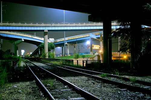
Cycling access? The Bailey bridge is pretty bike-friendly, as it is one lane (no on-coming traffic) and everyone pretty much crosses it at cycling pace. More importantly, the bike trail behind the Braid Station connects seamlessly, and the stretch on United Boulevard east of there is great for bikes: but ironically built too narrow for 4 lanes of traffic and bike lanes: no plan here to widen United. This project may hurt cycling access.

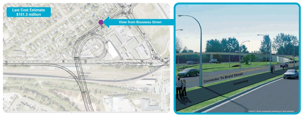
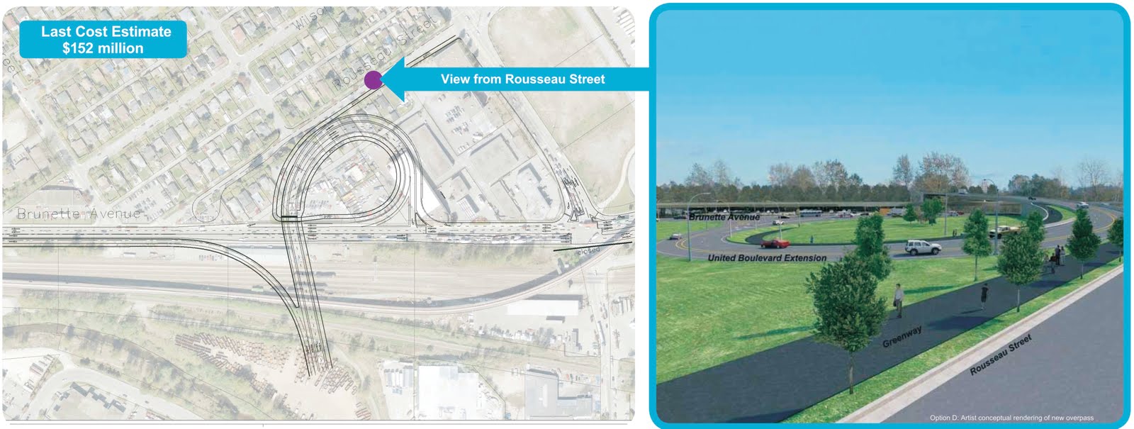
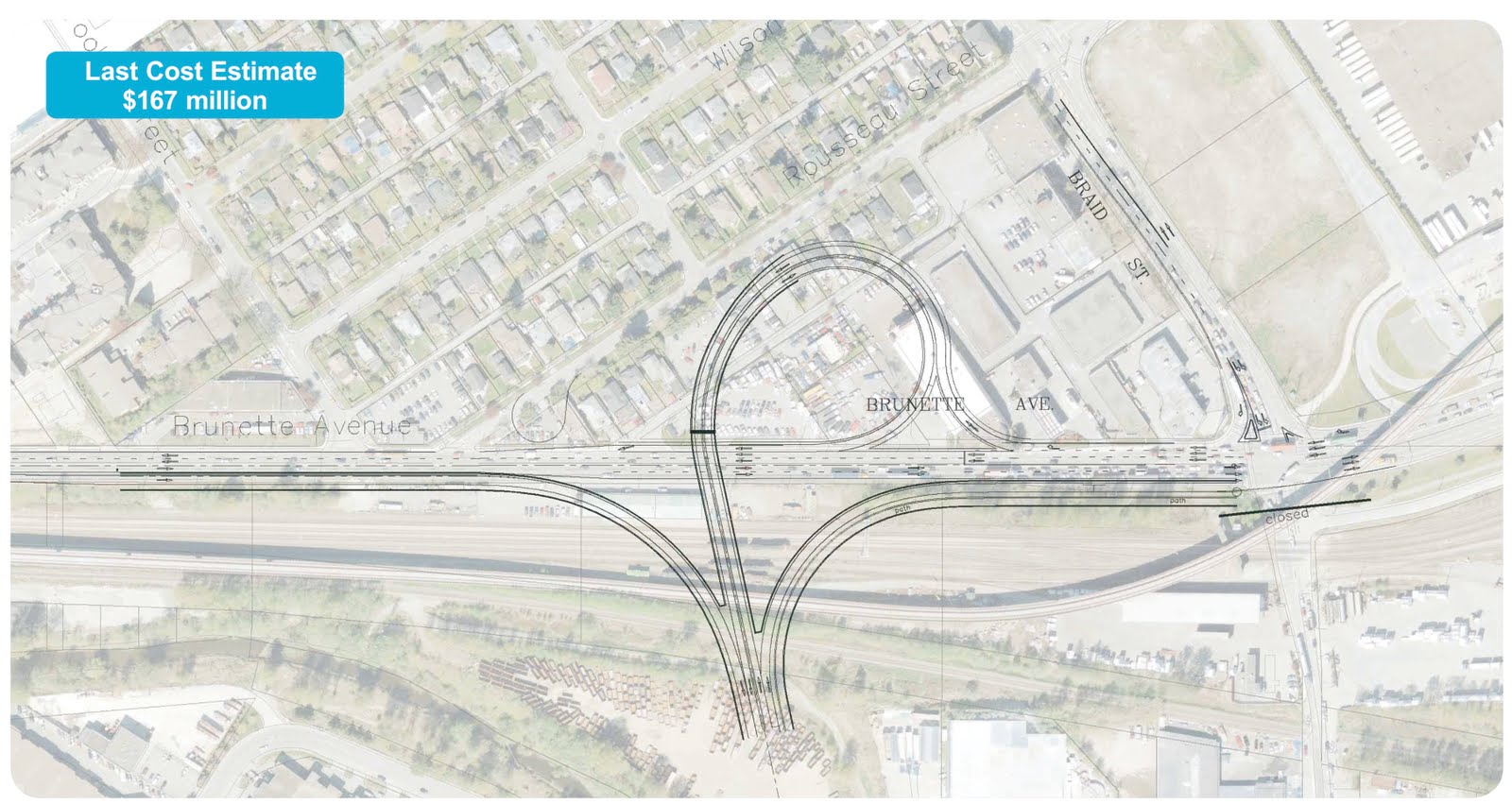
Seems to me, the only real “problem” being addressed here is the $65 Million dollars of Federal money that has to be committed by Christmas, before it turns into a pumpkin.

That seems like a lousy reason to spend another $100 Million and to invite more trucks and cars into our City. At least until there is a plan, with committed funding sources, to manage the traffic once it enters out City.

The good news is that I heard very encouraging things from the Mayor and Councillors who attended. This is not a done deal, and they all assured me no decision would be made unless it served the people of New Westminster. At this point, I am taking them at their word.

I was simultaneously encouraged and concerned by the Mayor’s words on the CBC this morning, which I transcribe here, in their entirety, for the record:

Why this project?

“In the lower mainland, there is properly not another pug for the transportation system or the trucking than there is on the Translink portion of the Gateway Project. That goes all the way from our Queensborough Bridge right through the City and ending up at the Braid Street Connection which goes onto Highway #1. And so, with this back-up, they have been trying to fix this for years and years since I’ve been here and we are in the process now of looking to see how do we do this so it mitigates the problems for the travel industry, but as importantly, how do we take care of the Citizens of New Westminster with as least an intrusion as possible.”

On removing houses:

“Well, first of all, before the decision is made that we will lose anything, we will make the decision. That has not been made. We made it perfectly clear to TransLink that we ware going to go to the public and let them see what the four options are, before council makes a decision of what their choice is. I can tell you, probably, there is no-one who wants the disruption you are talking about, and we are not going to support some disruption. Let’s see the people tonight, there will be lots of them coming out, I’m sure.”

Quote from Sapperton McBride Residents Association President (paraphrased): Residents were surprised, didn’t like “freeway interchange” design, wondered why were these options never raised in the past?

“Well, because they just came up (chuckle). So it is very simple. It was just brought to our attention, and as soon as it was brought to our attention, we said “Just wait a minute, we’ll take this back to the public, you will hear from the people of New Westminster, you’ll hear from this council, and then we will sit down and we will see what had to be done, if we want to go ahead with this. Because, if there is no benefit to the City of New Westminster, there is not going to be much support to go forward at all. We are trying to help the region, but the region has to make sure we are kept whole, that this City isn’t affected by just being a transition place for cars to drive through and hurt our neighborhoods. I can guarantee you that.”

On Federal Funding:

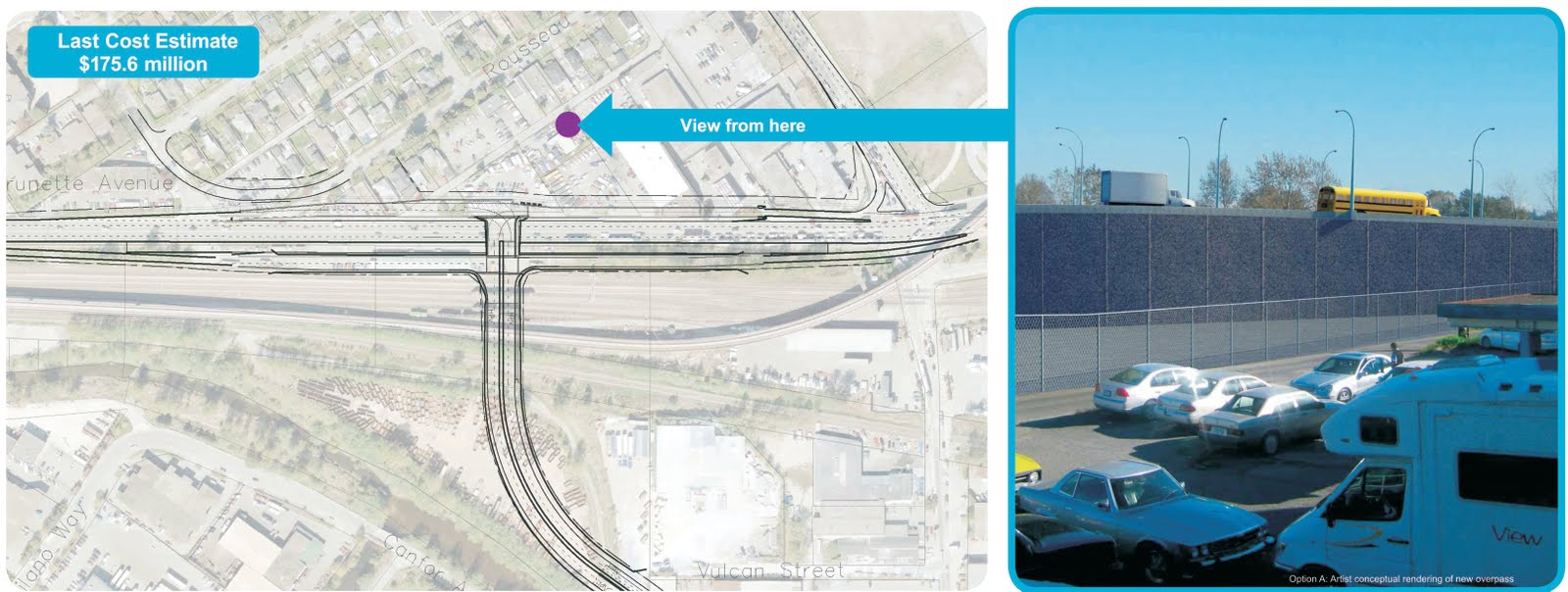
“The deadline for the matching funds, which is approximately $60-65 Million, is at the end of December, I think December 31st. Now let’ face it, it is good to have some additional funding that comes come through, but we have to be very careful that what we are going to do is not create more problems than what this amount of money will give. Now, since we have been in this situation for this piece of property or this roadway, it has gone three times the value that it was ten years ago, since I have been here. This comes right back to the funding. The funding for transportation has to be changed. It is no longer so simple that you give something that is so important to everybody in the region no method of funding. And that’s what this is. Now we are trying to match the $65 Million, it is still going to be short, we are going to have to come up with another 25 or 30 Million, if there is a particular choice that is made, because the choice that looks best for the City is what is called the “T”choice, in the shape of a “T”, and that T is I Think $170 Million dollars now, and the other choices may save them a bit of money, $120 Million or $150 Million dollars, but let’s face it, this is forever in this neighborhood, in this community, and we are going to go for the one, if we go forward, that is going to make sense for us, as well as the region.”

Where is the Grand plan? How does this fit a bigger plan?

“I have no idea, I have asked many times why TransLink has this piece of the Gateway. Why; no-one has ever been able to explain to me. But I can tell you this, we are also, with the uh, Translink organization, we have given them things that we need. We have given them the Front Street, which is our main downtown area, which is part of this, has to come forward, we have to have and agreement about how that will be fixed, if it is un… if it is encapsulation , if it is tunneling, but that has to be dealt at the same time as this. It is part of the broad corridor that is there. The Brewery study has to be done, that ii s where the old Labatt’s is, that corner has to be looked at, if you look at it: it is part of it. Then when you come down to McBride, You’ll see that’s where the trucks all stop because there is light down there that comes up from the bottom and it needs to have a tunnel. Now we’ve talked about that. We have talked about the bridge ramps that are coming. All of these things are part of a bigger picture you are asking about, and that’s what we are negotiating right now with the TransLink people”.

What about tonight’s meeting?

“I think the people will come forward, The question Mr. Pinkerton asked “how come we didn’t know before” will be answered pretty quickly. They’ll show all the slides, of what they want to do, and they will have some of us there saying “wait a minute, take a look at this, this is what we have been talking about for the past 10 years, and you people give us your opinions”. Now, I think we will end up, at the end of the day, people are going to say if it has to come, this is the particular one that looks like the one that we may be able to live with. Now give it back to the Council, let us negotiate with the Translink people. The council has been here long enough that, we don’t sit in a room with them and our staff and let anyone run over us. We’ll be alright.”

That last line was encouraging, as it reminded me of the neon sign/installation art by Martin Creed, visible over the DTES from the Skytrain when pulling out of the Stadium station. In big, white, friendly letters, the sign simply says: “everything is going to be alright”.

But I was also concerned that in the ten years he “has been here”, none of the traffic problems have been solved between the Queensborough and Braid. Yes, there are multiple jurisdictions, multiple pressures, no money, etc. But I think after 10 years of no action, our local leaders should stop looking for others to make their plans for them, and step up with some policy. After 10 years, we should have stronger statements from our local leaders than “let’s see what they offer, and if there is outcry from the public, then we will react”.

Instead of winging about our traffic fate, New Westminster should say what we will and will not accept for Front Street, for Columbia, for Braid, for Royal and for Eighth Ave. That way, when TransLink or MoT show up with hastily-assembled plan to patch one area, the answer from the City is is easy: does this meet the City’s policy objectives, our Master Plan? This year, the City is updating it’s Master Transportation Plan. Let’s include the higher-level policy statements about how we want to move cars, goods, and people thorugh our City. Let’s stop waiting for others to identify and scab over our traffic woes: let’s make policy now and get ahead of this issue. Beats waiting ten more years. The time is now.

No UBE for NW

The single biggest environmental issue in New Westminster today is not the “Toxic Blob” in the waterfront park. It is not the pending garbage incinerator. It is the United Boulevard Extension.

TransLink has cooked up a plan, using Federal stimulus money (your income tax), TransLink funding (your property tax + provincial tax), and …uh…some other mystery source… to more than double the number of trucks and cars that will enter the City from the east, with no plan to manage the traffic once it gets to the City.

And to make it more palatable, they are doing a Dr. Moreau melding of the project to the NeverGreen Line. And the whole thing is so fast-tracked, that the residents they plan to kick out of house and home were not even part of the consultation process.

This issue is covered excellently over on the Tenth to The Fraser Blog, and I think Matt Laird hits all the talking points really well over there.

The way I see it, New Westminster is a City with an enviable “sustainable mode share” (use of walking, bicycles and transit as opposed to private motor vehicles), but is still suffering from a significant traffic congestion problem. This is caused by a huge thru-traffic load. This is only going to get worse as the Port Mann becomes a toll bridge, and people divert to the Pattullo, and may become orders of magnitude worse if an increased-capacity Pattullo and the UBE come to town, bringing more cars and trucks to New Westminster’s residential streets, with no plans to move the increased traffic efficiently or safely through our streets.

All of the TransLink news of late has been about a “Funding Gap”. Major regional transportation projects like the Evergreen Line remain underfunded more than 10 years after they are announced, while our (soon to be former) Premier talks about trains to UBC and trains to Langley, with no plan to fund these initiatives. Meanwhile they are sneaking through a $150 Million highway project by tying it to the Evergreen, and pretending that it somehow “reduces greenhouse gasses” or “provides for non-SOV options” .

I can’t think of a more elegant way to say this: Bullshit.

The UBE does nothing to meet TransLink’s “6 Broad Goals” as set out in their Transport 2040 Strategy Document. It does not serve New Westminster in any way, and it takes money away from more valid projects that serve other part of the Lower Mainland better. Let’s kill this thing before it goes so far that it can’t be stopped.

Show up on Thursday at the meeting at the Justice Institute, not to protest, but to learn. The meeting will be run by TransLink staff, people who do not make the political decisions I am railing against, but are paid to bring plans to the public and answer questions best they can. Screaming, pulling of hair, calling of names will not be productive, these are not the people you need to convince that this plan does not work for you or your community.

Instead, one you know the plan, talk to your Mayor, and to your Councillors. In the end, they are the ones who are going to say “Yea” or Nay” to this project, and they are the ones you will be going into a polling booth in November 2011 to vote for.

Jerry Dobrovolny on The Olympic Transportation Plan

Comments on the NWEP’s forum on the future of Sustainable Transportation, held at Douglas College on November 9th, 2010. – Part 2

In the second part of his presentation, Jerry talked on how this one-time event can be used as a model for what transportation will be like in Vancouver in 2050, if the transportation plans of the City are realized. Much of this talk is actually available on the City Vancouver Website, so I won’t go into details here.

Short version: mode shift was responsible for getting most people to most events. Unlike recent Olympics in North America (e.g. Salt Lake City and Atlanta), Vancouver did not send a message for its Citizens to avoid downtown at all costs. Quite the opposite, they set up free events and pavilions around Downtown to encourage people to attend. They just told people to not bother trying to drive in Vancouver.

The City planned for a slight increase in overall traffic for the two weeks, and to avoid traffic gridlock, they hoped for 75% “alternative modes” (transit, bike, walking, rolling office chairs, crowd-surfing, and being dragged down the street on downhill skis being pulled by your drunken buddies I saw all of these on Granville. It was a good party). In the end, they got almost 80%. Notably, their initial estimates of total trips was way too low as there was a 44% increase in trips, but due to the high diversion rate, traffic chaos did not ensue.

Transit chaos only occasionally ensued. But TransLink did a great job managing it, and Jerry was quick to point out how pivotal their role was in running a successful games. I remember spending a half an hour in line at Main Street Station to catch a train home after a Hockey Game. But the line was well managed, organized, and moved pretty swiftly given the circumstances. Only at Jerry’s talk did I realize the people who were out on the street in yellow jackets organizing these lines were TransLink staffers: the managers, planners, secretaries, lawyers, engineers, and custodians who usually occupy TransLink offices were out on the streets during the Olympics, helping make things run smoothly.

Then there was the Olympic Line Streetcar, which proved it worth, moving more than half a million riders during the Olympics and Paralympics. Oh, to have streetcars on our streets again…

There is an inherent problem in all science: either you control all your variables and have an unrealistic model, or you collect real data from the messy real world, and then try to figure out what the variables are after the fact. This is definitely an example of the second half of this problem. It could be argued that the Olympics are a really terrible model for everyday life in the City. Many of the “trips” during the Olympics were taken by tourists, who were unlikely to use a car (as the City’s rental pool was way over depleted). Most of the trips were not people going to work, school, and everyday chores, but were people going downtown to enjoy the festivities: it is safe to assume they would tolerate more inconvenience on the way to the Closing Ceremonies than they would on a daily basis commuting to work. Sobriety is also a confounding factor in every day life that was no significant on February 28, 2010.

So the transportation plan worked, it proved that good planning and an integrated infrastructure not based on single-occupant vehicles can efficiently move larger numbers of people through Vancouver without increasing road capacity. But realistically, this is not the future of Vancouver transportation:

NWEP AGM: Separated Bike Lanes

The NWEP had a forum on urban transportation on November 9th, with several speakers touching on various topics realted to the evitable shift to more sustainable transportation. This is the first in a series summarizing some of the topics.

The first speaker was Jerry Dobrovolny, the Director of Transportation for the City of Vancouver. He also happens to be a New Westminster Resident, and was once a City Councillor here in Richmond. He spoke on two topics wrapped in one title:

“How the Olympics and Separated Bike Lanes are helping Vancouver become the Greenest City in the world by 2020”.

First, on the bike lanes.

Jerry brought a lot of perspective to the issue of the Separated Bike Lanes that is lost in the recent media hype about the issue. Surprisingly, these bike lanes are not an evil conspiracy of a single bike-friendly Mayor, or even of a rabidly socialist Vision Vancouver Council . They were established as part of the 1997 Transportation plan that was passed under (NPA) Mayor Phillip Owen, supported by (CoPE) Mayor Larry Campbell, (NPA) Mayor Sam Sullivan, and the current (Vision) Mayor and Council. They are one link, (the previously “missing link”) in a City-wide cycling infrastructure program that has been happening for more than a decade.

They are also not new, but reflect what is quickly becoming the “standard” for road construction in urban areas, in Montreal, in New York, in Portland… Not to mix metaphors, but we aren’t reinventing the wheel here.

And it works. The money being spent on these cycling improvements in Vancouver is about $4 Million, out of annual transportation budget of about $125 Million, so about 3% of the budget. But in the downtown core where these improvements are happening, around 12% of all trips are by bicycle. Cyclists are no using roads they don’t pay for (roads are overwhelmingly financed by property taxes), they are actually subsidising other road improvemetns by a factor of four.

Since the 1997 transportation plan, the City’s population has increased more than 25%, jobs more than 20%, and the number of cars entering the city on a daily basis has gone DOWN by 18% (and these numbers are from before the Canada Line opened).

Yes, a few parking spots were lost on Hornby; 158 spots in total. However, as part of the program, 162 spots were added to Howe and Seymour Streets (one and three blocks away, respectively), which pales in comparison to the 10,000 off-street parking spots available within 1 block of the Hornby Street bike lane. If you survey people on Hornby, you would find 90% of them walked more than 2 blocks to get to their desination. In other words, the parking issue is another non-issue.

I wish Big, Fat, David Pratt and professional blowhard Bruce Allen were challenged with some facts for a change. Alas, that isn’t their job, is it?

More on transportation

My letter in Today’s New Westminster News Leader (with some links added, for internetty reasons):

It was interesting to read the recent discussions in the NewsLeader about Tenth Avenue and the Stormont Connector, the routing of the planned Pattullo Bridge replacement, and the impacts of these regional transportation projects on our neighbourhoods.

I couldn’t help but note that the compelling arguments Mr. Crosty made for “encapsulating” McBride Boulevard (reduced traffic and safer communities, reduced pollution, reclaiming valuable land while bringing our divided community together) could equally be made for completely removing McBride Boulevard.

Instead of spending billions burying a problem soon to be made worse by expensive expanded bridges and new connectors, perhaps we should take a fresh look at what the alternatives are to building more roads.

Are we still labouring under the illusion that building roads is a solution to traffic?

This topic and others will be the basis for an open forum on transportation planning that the New Westminster Environmental Partners will be holding as part of its annual general meeting.

We will be bringing together transportation experts and sustainable transportation advocates to discuss the future of the regional transportation system and how this will impact New Westminster.

If you have questions, concerns, or ideas about the Pattullo Bridge, the Stormont Connector, the ongoing TransLink “funding gap,” or other aspects of the local and regional transportation puzzle, please come by the Douglas College Student Union Lounge on Tuesday, Nov. 9, at 7 p.m., and join the discussion.

For more information, see the NWEP website for details: www.nwep.ca.

For those in need of inspiration that sustainable transportations work in the real world, I suggest showing up to see Jerry Dobrovolny talk about the transportation plan for the Olympics, and how it really, actually, in reality, no shit, worked.

Another really inspiring story is that of Cheonggyecheon, and some more examples of Braess in action.

See you next week.

A Pause in programming:

I have been pretty busy, working on this:

It should be a good event. The topic is relevant for several reasons. The City is developing a new Master Transportation Plan right now. The Province is spending a few billion dollars bringing more cars to our eastern border. The North Fraser Perimeter Road will include the United Connector, which will include the expansion of a one-lane bridge (already part of a long-standing dispute ) to a four-lane bridge and the passing-over of a rail line currently signal-controlled- with no plans to adapt New Westminster traffic to fit the new capacity. Rumblings are afoot about reviving the Stormont connector. The Pattullo is due for an upgrade. Translink is mired in a “funding gap”, while the Premier runs around promising trains to UBC and Langley while still not funding the trains he promised last decade. Still, no-one is talking about Front Street.

Our speakers are high-quality: Jerry Dobrovolny used to be a City Councillor in New West, and is now Director of Transportation for the City of Vancouver. He will be talking about the massive transportation success that was the 2010 Olympics, and how that relates to longer-term plans in Vancouver to increase the “alternative mode share” (people transporting themselves without cars).

Joe Zaccaria from South Fraser OnTrax has been an advocate for a better regional transportation system, and smarter development South of the Fraser. Since most of New Westminster’s traffic problems are caused by through-travel, and most of that through travel goes across the Fraser, his interest inevitably is our interest.

Finally, Jonathan Cote is a City Councillor here in New Westminster, and is also an advocate for alternative transportation (who lives what he preaches: I see him walking by my house to go to work every day!). He will be talking about the future of development in New Westminster, and how municipal planning can result in high “alternative mode share”. I suspect he will also be talking about the “funding gap” and road pricing as a policy.

So come out, let’s hear what you have to say. Hopefully we will find a more…uh… nuanced approach than this guy: