ASK PAT: Heavy rail

Tom asks—

Hi, loving your blog!
Bit of a general question: Do you think heavy passenger rail, of the type found commonly in Britain or Switzerland, could ever be useful in the Lower Mainland, and as an international connection for Cascadia?
Thanks for your time.

It already is! The West Coast Express is a pretty successful heavy rail transit system right here in the Lower Mainland and run my TransLink. By “successful”, I mean it is reliable, popular, and regional-development-defining. There is a debate about how to assess the financial success of the service, as they do pay a significant lease rate for the CP tracks they use, which requires the service to be subsidized from TransLink general revenue. But subsidizing passenger rail for the larger societal benefits is the norm in Europe, not an exception.

Of course, there are also rail connections to the rest of Cascadia, even if they are not really operated in a way that makes them “commuter” friendly. I would suggest until we develop widespread electrification of rail and the economics of aircraft travel are adjusted to match the environmental impacts, there simply isn’t the population density or economic model to push more rail through the challenging Cascade Mountains. Maybe the next generation will fix this.

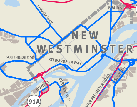
There may be more potential in the nearer future for commuting in the Fraser Valley, though. There has been an activist group in the Lower Mainland for more than a decade fighting to get more rail service South of the Fraser. Over the years, “Rail for the Valley” have discussed the use of heavy and light rail options, specifically along the old Interurban rail corridor. This electric rail line used to operate between Vancouver and Chilliwack via New Westminster before the rails-to-rubber movement stripped it of customers and land back in the middle of last century (see Who Framed Roger Rabbit for more context).

It is clear that the long-range development model for the Fraser Valley is one that would support a heavy rail based commuter transportation system. Cities like Abbotsford are buying into the Smart Growth model of building denser urban centres with mixed uses and pedestrian and transit amenities. This is partly driven by economics working better for cities trying to deliver services, but mostly because the ALR continues to limit their ability to spread out as their populations boom. Extending the “Cities in the Sea of Green” motif could see Langley, Chilliwack ,and Abbotsford town centres connect to Surrey’s new “hub” via the existing rail corridors to King George or Scott Road.

This would really open up economic potential for those communities, and indeed for Surrey and the rest of the Lower Mainland. However, that is not the path we are on. Instead, we have spent $5 billion (and counting) on building freeways to get cars in and out of the Valley, and it appears the Provincial Government is dedicated to that path. Meanwhile, even the most modest of public transit improvements in the Lower Mainland are stuck in a funding and planning quagmire because one of the three levels of government simply refuses to show leadership or foresight.

A region-defining development like this would need a sense of vision. The Local Governments have shown similar vision, the federal government is ready to step up and fund bold initiatives like this. But much like any poorly-functioning transportation system, there is a piece in the middle that just doesn’t allow the connection to happen, and gums up the whole works.

Is it a good idea? Yes. Will it happen in the foreseeable future? No.

ASK PAT: Housing idea

Terran asks—

What do you think about the recent Vancouver idea to buy homes and undervalue them? Do you think this could work in new west? http://www.cbc.ca/news/canada/british-columbia/city-of-vancouver-affordable-home-ownership-pilot-program-1.3539688

I can’t quite get my head around the City of Vancouver plan. They appear to wan to buy 20% of the housing value, and hold that portion while the market still influences the pricing of the units. If I understand it right, a middle-income-family would by 80% of a home, live in it, sell it off and receive 80% of the sale price. If the value goes up (as is likely today) when they choose to upgrade or move to Temiskaming, do they get 80% of the capital gain and the City the 20%? There are devils in details here.

My first question when putting this in the New West context would be –is it legal? Vancouver seems to be floating the idea of making changes to the Vancouver Charter to make it work, and I’m not sure how this model would fit into the Community Charter that governs New West.

There is another simple resource problem: New Westminster does not have a lot of money. We don’t really have a longer-term land acquisition strategy to speak of (we are working on developing one now), nor do we hold a lot of property relative to many of our surrounding communities. Investments that could have (should have?) been made decades ago when land values were low were not done for what I’m sure were very practical reasons at the time. Our finances are pretty good, but the few capital projects we have coming along in the next few years (Massey Theatre, Q2Q, Canada Games Pool, etc.) are going to tighten things up quite a bit.

This raises the question if this is the most effective way to leverage the money we do have. The City holds about $1Million in our Affordable Housing Reserve, and we have a task force working on a couple of strategies to leverage partnerships to assure those funds go to where they can make the best impact.

Finally, I wonder if the Vancouver solution (making apartments 20% more affordable for essentially middle-income workers) is really the affordability problem we need to solve in New West. I get the sense that New West is affordable for middle-income earners, especially if they are happy to live in an apartment setting. Single Family homes are getting out of reach, but building more “missing middle” housing types like townhouses, laneway houses and cluster homes might help provide better options to those earning family incomes in the $70-90,000/yr range (the target of Vancouver’s plan).

In New West, we are seeing creeping land costs and a paucity of rental availability that is putting a lot of stress on the lower-income cohort of our population. As the working middle are pushed to New West, they are displacing the working poor and underemployed who need affordable housing within transit or walking distance from their jobs, their schools, and their support systems.

Unfortunately, this situation is getting worse at the same time that the largest community network of affordable family homes – Co-op Housing – is going through an existential crisis caused by the federal government cutting off support, and the provincial government failing to fill the gap (as is their constitutional role).
In the meantime, New West is doing what it can to get both market and non-market rental built as soon as possible, and to develop a new Official Community Plan that emphasises diversity of housing choice. Meanwhile, the Mayor has an Affordable Housing Task Force that is working on the best potential use of the affordable housing reserves, and the Mayor himself is working with the Metro Vancouver Housing Board to develop regional affordability strategies.

Not that I am disparaging of Vancouver’s idea. In this strangely super-heated market, coupled by a booming economy where everything but wages are going through the roof, we are going to need a variety of strategies to keep our region livable. Housing is a symptom of a larger economic malaise that points back to decades of neo-liberal economic “progress” where the building of wealth is prioritized over the building of society. But that is a talk for another day.

ASK PAT: Front Street trucks.

Brad asks—

During Front Street’s closure over the past couple of months, trucks have been re-routed to Columbia and Royal. This doesn’t seem to have had that bad of an affect on New Westminster’s traffic (at least, to my eye), so what are the thoughts about banning truck traffic from Front Street entirely? Can this be visited when the Pattullo Bridge gets replaced? Front Street isn’t part of TransLink’s Major Road Network, so we shouldn’t have to ask them, right?

Although I agree the “Carmageddon” promised by Front Street closing has not arrived, there has been a shifting of trucks to Columbia Street, and anecdotal increases in trucks on Royal and 10th Ave. The City is collecting data on the traffic during the closure in order to get good numbers on the shift, and that report is not available yet, but preliminary info seems to suggest about a 30% increase in trucks on Royal. There has also been a diversion of trucks to Columbia and 10th Ave, but these three increases do not add up to the number of rucks that used to ply Front Street. It is pretty clear that a large proportion of the tucks that were on Front Street have, indeed, gone away. Presumably most of them have gone to the $5 Billion of freeways we have built for them over the last decade, as the Lord Kevin Falcon intended.

Front Street is not in the Major Road Network, but it is a designated truck route. To change that, we need agreement from the Ministry of Transportation and at least consult with TransLink. The current policy is that trucks routes cannot be removed unless appropriate alternatives are offered. So if closing Front Street to trucks means we need to allow 24/7 access to Columbia Street, then it is probably not a good deal for the City.

Capture2

If the closing of that route means accepting a measured increase in Royal Ave and 10th Ave, then perhaps it is a discussion we should be having as a City. However, to have that discussion, we need some solid numbers to support the cost-benefit, and those numbers are being collected. Of course, this ends up being a political discussion – the people who live on Royal are not going to like it, and it will do nothing to make people feel better about the Qayqayt school transportation situation.

Offsetting these reasons to avoid the discussion, people need to go down to the Front Street right now and look around. I think we can, for just a moment now, have a vision of what could be. I’m not even talking about removing trucks from Front Street, I’m thinking we should explore the possibility of closing Front Street to all but local traffic. Build the Mews, turn the rest into greenway, parkland, open space for any of a thousand public uses we have not yet imagined. I don’t want to close Front Street to traffic, I want to open it for the use of human beings who aren’t dragging tonnes of internally-combusting metal around with them. There is a huge amount of space there, let’s start to dream.front

The primary argument for keeping trucks in Front Street is, of course, “Goods Movement”. The Gateway Council, the Port, the BC Trucking Association, and the Ministry of Transportation make the argument that the regional economy relies on free-flow of trucks along Front – this route is critical. This assertion will not likely be supported by any measureable dip in the regional economy caused by this 6-months closure. But don’t bring facts into this discussion.

Fitting the use of Front Street into the context of the larger Pattullo replacement strategy is important, as is fitting it into the model for the Brunette overpass replacement, which is an ongoing discussion between Coquitlam, New Westminster, and the Ministry. There are well-connected regional voices continuing to reiterate that New Westminster is a through-route, not a community, and are planning with this in mind.

Even as New Westminster aggressively pursues a smart growth strategy reflecting the Regional Growth Strategy; even as we push towards building a compact, mixed-use, transit-oriented community where most commuting and shopping trips are by foot or transit, reducing the need for expanded road capacity; even as we take a leadership role the region in meeting the mode shift goals of the long-term regional transportation vision, those very goals are challenged by our tacit acceptance that our community must play second fiddle to the commuting needs of outlying regions.

We have been leaders in planning and development to reduce our reliance on the traditional transportation models, we are becoming leaders in our transportation policy, but to see the benefit of those changes here at home, we may need to stop leading by example, and start forcing our neighbour’s hands.

Does the region need trucks on Front Street? No. Is there a better way to make use of that 5 acres of public space in New Westminster? Yes.

The rest is politics.

ASK PAT: road pricing

Wes asks—

I’ve heard a lot recently about road pricing, as a means to fund transit and road infrastructure. What does this actually look like ? Ts it transponders and sensors all over the Metro area? Is it simply a declaration at time of insurance renewal of Vehicle KM last year and current Vehicle KM ?

I think the short answer to this question is we don’t really know yet, but we can make a pretty qualified guess.

In my earlier posts, I talked about how the “$1-toll-for-all-bridges” idea could be refined into a more practical regional road pricing model. This model would expand the Port Mann / Golden Ears transponder and licence plate scanning model to maybe a dozen locations at logical “pinch points”. That is a quick and dirty way to make it work, and uses proven technology and bureaucracy that already exists. I don’t think anyone thinks this is the long-term solution, but it is a move we can get going very quickly and get the public used to the unpopular idea that roads aren’t free, if we have the political will to make it happen.

The long-term plan is something that is discussed in the Mayor’s Plan, but was blithely ignored by the media and Bateman during the Plebiscite. The plan was very clear that the sales tax was a 10-year cash infusion for capital improvement to build the required alternatives prior to the implementation of a proper road pricing model. The plan was for increased user revenue and road pricing to increasingly fill the revenue gap to allow for continued development of the system:

“LONGER TERM: Staged introduction of mobility pricing on the road network Over the longer term, the Mayors’ Council is committed to implementing time-and-distance based mobility pricing on the road network as an efficient, fair and sustainable method of helping to pay for the transportation system.

“Mobility pricing on the road network would help generate funding to implement the remainder of this Vision and shift taxation away from the fuel sales tax—which is a declining revenue source due to increased vehicle efficiency and leakage to areas outside of the region. By generating $250 million per year from a fair, region-wide approach to mobility pricing on the road network, we will be able to fund the remainder of this Vision and at the same time reduce the price paid at the pump by about $0.06 per litre.” – pg. 36, Regional Transportation Investments: a Vision for Metro Vancouver

Systems to make this work are limited to a few existing (and a few speculated) models. The model common in the US, Europe, and Australia of charging distance tolls on limited access freeways (“Turnpikes”) based on how many exits you have passed, is probably not a practical system for BC. We have few true limited-access roads: Highway 1, and 91 and 99 south of the Fraser. Even the new South Fraser Perimeter Road is doesn’t really fit the limited access model for much of its distance. With interconnected surface roads providing alternatives and a demonstrated proclivity for local drivers to value their money more than their time, this approach is doomed to a CLEM7 failure from the start.

There are two other ways to imagine road pricing, both potentially administered by ICBC.

The simplest is a charge-per-use model where every year you report your mileage to ICBC when you update your insurance, and pay a per-kilometer charge. This is potentially the least intrusive model, but the model most likely to see tax avoidance. With modern cars, it is a bit of a complicated process to just “crack open the odometer and roll it back by hand”, a la Ferris Bueller, and there is generally electronic data storage onboard that may have be useful. Of course, this would be easier if we still had an AirCare infrastructure to put to use, but it might be in inferred “unfairness” of the model that makes it least palatable. Expect questions like “If I take a road trip to San Francisco, why should I pay BC roadtax on that?” or EV owners whinging that they should get exempted, as they often conflate their reduced GHG output with other urban design issues related to the single occupant vehicle. This also does not allow differentiation of rates based on where and at what time the mileage is run up, significantly reducing the Transportation Demand Management (TDM) utility. Should you pay as much for a Sunday drive to the park as you do for crossing the Pettullo at rush hour?

The model that would likely work best is, unfortunately, the one that is going to create the most political pushback for mostly nonsensical (and therefore hard to refute) reasons. This is the placement of GPS-type transducers in all vehicles insured in BC, and piggyback on the existing cellular networks to track all vehicle movement. This is a significant data-crunching challenge, as there are something like 2 Million vehicles registered in the Lower Mainland, but the benefits are huge. True distance and time-of-day charging can be done to get the best TDM benefits. It would be arguably the most “fair” process to balance the needs of all users, although there would be a Smart-meter type push back.

There would also be significant devil-in-the-details around how the pricing scheme was developed. In todays’ provincial and regional political climate, it would be hard to wrest that decision making from the politicians, and parochial battles would no doubt ensue. There could be interesting side benefits (it would essentially end car theft, as stolen vehicles could be easily and quickly be tracked) but these would no doubt be offset by the brain melt it would cause for civil libertarians (why does Big Brother need to know where my car goes!?). Ultimately, this is probably politically impossible in our current regime. Perhaps this situation will change as the next generation raised on smart technology are the descision-makers, and we are ready to re-think transportation as a technology challenge.

This speaks somewhat to Helsinki’s one-card model for all transportation modes. They are building a scheme where you pay for a “transportation card”, and you can use that to pay for all transportation choices: road tolls, train tickets, bus passes, bike share, taxis, Car-2-Go type car share, everything. Prices can be made flexible for time/congestion/availability issues to manage the entire system more efficiently, and you can walk out the door of a building and decide what mode (or combination of modes) is best to get you to your next destination with seamless transitions. But we are nowhere near there yet in North America.

In the end, the tolling of bridges (and possible other “gateways” such as North Road, 264th Street, Horseshoe Bay, the US Border, etc.) through an expanded transponder/licence plate scanner is the best we can practically hope for in the decade ahead. It has been working in Singapore for years, and has seen success in London and other European cities. It is a little kludgey, and definitely sub-optimal,  but as I have said before, we can’t let the perfect be the enemy of the good, and we need to start moving this conversation forward as a region.

Ask Pat: Safety Dictator

Nicole asks—

Since your wonderful idea of a 30 km/h urban speed limit has drawn some ire, what other controversial things might you do to make our roads safer if you were made Dictator of BC for, say, a year? (I am guessing that photo radar is very high on the list, if not number one.)

Ire!? If an idea doesn’t draw ire from some sector, it is probably not worth even discussing. You may have heard some ire, I heard a lot of people saying its about time. Just this week, there were articles in Price Tags (Vancouver’s best Urbanism portal), there have been great results out of Toronto on their speed reduction program, and Seattle has joined the fray. I even took this photo at the Janette Sadik-Khan talk in Vancouver on Tuesday night:JSK20

Ire be damned, I want our streets to be safer. As JSK herself says: “When you challenge the status quo, it pushes back. Hard.”

I like the tone of your question, however. What would I do if I was Dictator for a year and was able to do whatever I wanted to make roads safer? Not sure I could get it all done in a year, but Dictators have armies to do their bidding, right?

Photo radar has it’s use. The Pattullo Bridge is a perfect example of a 50km/h road where everyone goes 80km/h and the resultant accidents are incredibly dangerous for other bridge users. It also reduces the inferred safety of the bridge, and is used as a primary reason for replacement. With careful application and an emphasis on safety (as opposed to punitive punishment in places where poor road design encourages speeding), photo radar has a role.

Look at this stupid road. Nothing here tells you to go 60km/h, except the sign. Of course everyone goes 80
Look at this stupid road. Nothing here, not the >3.5m lanes, not the generous shoulder and fixed divider, not the wide-open sight lines, nothing tells you to go 60km/h, except the sign. Of course everyone goes 80 or faster. A silly and punitive place to put Photo Radar, but dollars to donuts, the first place it would be installed.

I also think intersection cameras have a role. There are some in New West, and ICBC and the Integrated Road Safety Unit have a program to support them. However, they seem to concentrate on the red-light runners, likely because it is the easiest thing to enforce with a camera. I’m just as concerned about illegal turns, failing to yield to pedestrians, and entering intersections you have no possible way of exiting in order to “beat a light cycle”. With all the talk of distracted pedestrians and dark clothing, it is a pretty important point that the majority of pedestrian fatalities are caused by the driver failing to yield right of way in an intersection.

To make roads safer for cyclists, I would start by implementing (almost all) the recommendations that the Ontario Coroner released a couple of years ago after investigating cycling deaths in the province. I wrote a long piece on this once, but in summary: build safe infrastructure for cyclists, improve education for school students and all drivers, pass a 3-foot rule, and so on. We already have a pretty good idea what works, this isn’t radical or anything surprising. All that is lacking is the politcial will to make it happen.

The next big step would be nothing less than a complete re-writing of the design standards for urban streets. This is major part of Janette Sadik-Khan’s thesis for road safety. The existing standards for road design, paint markings, signs, and other treatments are from a different era, and were developed with the desire to make driving through our cities as efficient as possible, with only a nod to driver safety. That the “efficient movement” of cars makes the environment for all other road users less safe does not seem to be addressed.

JSK points out the American road design bible (“Manual on Uniform Traffic Control Devices”) has more than 800 pages of diagrams and plans describing the standards, 800 pages in which not a single pedestrian is shown. This book (along with it’s Canadian version) needs to be thrown away.

The good news is that there is already a lot of work being done on a better book to replace it. The National Association of City Transportation Officials has a go-to book called “The Urban Street Design Guide” That needs to become the standard, not the alternative. We can no longer use a 1950s guide book to adapt our 1920s streets for 2015 users. Time to challenge the status quo.

This probably exceeds the authority of the Dictator, but I would also change the laws to make cars safer. This engineering work is being done primarily in Europe, and some of it is becoming mainstream, but we can and should make more changes sooner. This includes a suite of things: better crush zones in front bumpers; softer hood materials with larger energy-absorbing gaps between sheetmetal and hardpoints; use of active cushioning (airbags); injury-reducing body shape geometry; larger windows with smaller pillars to improve driver visibility; active and passive collision avoidance systems.

While we are at it, we can add regular vehicle inspection to assure these systems work, and have not been messed with. There is no place in the urban environment for the suite of modifications that make automobiles unsafe for the people sharing the environment: trucks lifted to ridiculous heights, bull and grill guards, black tinted windows and lights, etc. I know that this is a radical idea in a society where many people consider their car an extension of their personality, and anything that impacts the design of their car would be seen as squelching freedom of expression.

Talking about Freedom of Expression, I am a keen follower of the move to change the language of traffic crashes. Read your local newspaper about a pedestrian being killed by a driver, and the headline is usually some form of “Pedestrian killed by car”. The events are always referred to immediately as “accidents”, which makes them sound inevitable, something that just happens, and presumes there is no fault (and, by inference, nothing we can do about it).

We can change how we value public space and our expectation of pedestrian safety by simply changing our language. “Pedestrian hit by driver of car” makes it clear there are two people in the transaction, not a person and an inanimate object. “Collision” and “incident” are both better terms than “accident” until the police and ICBC have an opportunity to determine the cause of the collision (inattentive driving? texting while walking? bad street design? non-functional brakes?). I think words mean something, and the words we use frame the discussion we will have, and we need to have a better discussion, because people are getting killed and we should have no tolerance for it.

Boy, I really sounded like a Dictator there, eh?

Ask Pat: Tipperary U-turns

Chad asks—

I’m a Brow of the Hill resident who walks home from the Skytrain at Columbia St up 4th St every day. I’m wondering about the deal with Royal Ave and 4th St. Every day I see dozens of cars getting around the no right turn restriction on to Royal Ave by driving into the Tipperary Park parking lot and doing a u-turn. (Where I frequently feel I’m at risk of being run over). I’m especially concerned about this as the days get warmer and longer and more people will be making use of that great park, while those using New West as their highway between home and work zip around in the parking lot to try to bypass part of the Royal Ave traffic parade. I can see that there is a no u-turn sign in the parking lot but no one’s paying attention to it – makes me wonder why they even bother obeying the no right turn sign…anyway, would love to see this area made safer for pedestrians and park goers alike, and would greatly appreciate your thoughts on this!

It has taken me more than a month to answer this question, mostly because I don’t have an answer.

It isn’t only the “no right turn from 4th to Royal” folks who do this. It is also the “no left turn from 3rd to Royal” who turn right instead, go the block and pull a u-turn. Mix these with the people who drive through the City Hall parking lot and access 4th from there instead of waiting a light cycle on 6th

It is a mess. We have (according to some counts, although the source of this oft-cited number is somewhat obscured by urban legend) 400,000 vehicles a day passing through New Westminster, and for an hour or two a day, the legal accesses to the Pattullo Bridge are constricted, and those through-commuters do whatever they can to take a few minutes off their commutes. Except pay a toll on the Port Mann, of course.

It has been measured, this increase in 20,000 vehicles a day crossing the Pattullo (about 30%) since the tolls were applied at the Port Mann. There is a coincident 20,000-vehicle drop in daily crossings of the Port Mann. This is a huge part of the reason why this City has been working so hard to assure that any replacement for the Pattullo Bridge will result in a tolled crossing – to level that playing field. We are also lobbying to assure the bridge is not higher-capacity, as induced demand will assuredly result in congestion on the feeder routes increasing as capacity does. Finally, we worked to encourage people to vote YES for the funding of the Mayor’s Plan to bring better transit service South of the Fraser so those 10,000 extra people had viable alternatives to sitting in traffic in New Westminster and getting frustrated enough to pull a u-turn in a parking lot to shave a few minutes off their trip.

We can target enforcement in places like you mention, and the NWPD does have a traffic division who do this. Their priorities are not necessarily to catch “rat runners”, but to target the most dangerous road users at the most dangerous intersections. With a few thousand intersections in the City and a million road signs, they can’t be everywhere enforcing everything (and enforcement costs money!), but they are doing what they can against the tide.

So no easy answers, and yes I share your concern, but I don’t know the solution. I’d love to hear if you have any ideas to make the situation safer.

Ask Pat: tax increases

RA asks—

This past year the assessed value of my property has increased by $150,000. Approximately a 30% increase. Using the property tax estimator, entering a rate increase of 0% results in an increase of my tax payment of 18% due to assessed value increase alone. Therefore this more than covers the 2.67% the city proposes. I understand that many homes faced similar increases this past year. For these reasons, I am not in favor of the tax increase proposed.

Can you tell me how the city has factored in the large assessed value increases into its budget and resulting proposed tax increase?

Wow. 30% in one year is crazy. It would be nice to think you made $150K this year just sleeping in your bed, but that doesn’t do you much good if you can’t sell – you have to put that bed somewhere. However, the short answer to your question is: it hasn’t. The longer answer is below.

Your assessed increase was significantly above the average increase in property values for the City over the last year, which was 11.7%. This means you are going to get dinged by the property tax system more than most. However, that doesn’t mean the City is getting extra money, it means someone out there in New West must have got an assessment increase less than the average, and they will see a relative tax savings this year.

The better way to answer your question is by going through a quick example of how the Assessment/Mil rate tax math works.

First off, the City has not yet settled on a tax increase this year. The current draft of the 5-Year Financial Plan that needs to be done by May (the “budget”) is built around a 2.73% increase. That is (more likely than not) the number that is going to come to council in the form of a Bylaw sometime in April. This means the City plans to collect about $1.8M more this year than we did last year in order to balance the budget. About $1.3M (1.97%) of that is “base budget” increases – inflationary increases that, if not approved, would result in a reduction in existing programs and services. The other approximately $0.5M (0.76%) is new departmental requests: things like additional staff to enforce and administer the Tree Bylaw.

Using the City’s handy tax estimate calculator, you can enter 2.73% and your assessed values from 2015 and 2016, and get an idea how much your taxes are likely to rise this year. For the fun demonstrative value of it, I entered several values for property assessment increases and City tax increases, and plotted out the results:

grahp

On the Y-axis (vertical) is the property value increase from BC Assessment. I don’t think many properties went down in value, and your 30% is the highest increase I have heard of, so this should cover most of the range of residents in the City. The average increase City-wide was 11.7%, which I show with the thick grey line. On the x-axis (horizontal) is the amount your tax bill will increase based on the three scenarios represented by the green line (City tax increase of 0%), the blue line (the City’s proposed 2.73% increase) and just for comparison, a 5% tax increase shown with a red line.

You can see that for the average assessment increase (11.7%) the tax increase is equal to the City’s set increase. As your assessment increase is an astounding 30%, your tax increase is going to go up much more than this, and the relationship is linear: if we raise taxes 0%, you will pay 18.3% more, raise taxes 2.73% and you will pay 21% more, raise them by 5% you would pay 23.3% more. My assessment went up about 17%, so my numbers would be 5.3%, 8.0% and 10.3% respectively.

However, 11.7% is the average increase for the City, so for every property that increased more than 11.7% there is one that increased less than 11.7%. For the owner of a property that went up 10% in value, the proposed tax increase is about 1% (less than inflation), and any property that increased by less than 8.7% in 2016 will see their taxes go down. I know you are sitting on a 30% increase and the regional real estate numbers are crazy, but by the virtue that your property went up almost 3x the average, there must be a large number of properties in the City whose increase was less than the average, and even below that 8.7% threshold.

To sum up, the big point here is that the City does not look at the assessed property value increases when calculating the tax increase required for the year. We look at our budget and determine what our need is to deliver the services required. This year it looks like about $1.8Million, so for every $100 we took in from property taxes last year, we need to take in (about) $102.73 to deliver those services and balance the budget. If the average property assessment was 1% above last year or 100% above last year, it does not change that 2.73%, and the only thing that increases or decreases your tax burden is the amount your property increased or decreased in value relative to the city-wide average.

If you think a 30% increase is not realistic, then you are able to appeal it. Too late now for 2016, but 2017 is just around the corner. The BC Assessment office doesn’t work for the City, so we have no say in how they do their work, but there is an appeal mechanism, and if you think your out-of-scale assessment is wrong, you can appeal. If you were to get your 30% increase appealed down to 20%, you will cut in half the amount of tax increase you experience. As a City, we have no skin in that game (because every one of your neighbours’ taxes will go up slightly to offset your reduction), but as homeowner whose assessed value went up 17% last year, I’ll be sharing your pain.

Ask Pat: Crappy Park

Someone asked—

Hi Pat, I am just inquiring about Sullivan Park on Oliver Street here in the Queen’s Park neighbourhood. It is a lovely park and really close to our home. However, I am noticing that there is a lot of dog dropping being left all around the park. I am not sure if this particular park is monitored but something needs to be done. It is horrible. I refuse to take my 14 month old there anymore as I am worried he is going to fall into it.. or worse. Anything you can do for us?

Shh! I didn’t think we were allowed to talk about Sullivan Park. It’s one of those neighbourhood secrets that we aren’t supposed to let anyone know about.

One general rule about a persistent dog-crap problem in a location is that it is probably just one person. Most dog owners are responsible and don’t want crap lying around any more than the rest of us, but one or two bad apples definitely can result in a lot of… uh… road apples. Unfortunately, catching that one person is probably near impossible.

My first suggestion is to use SeeClickFix when you run into a problem like this, to make sure it gets onto the City operations radar. If you aren’t a smart-phone lover, you can use this on-line form to make sure your issue gets tracked and followed up on. Or call Parks, Culture and Recreation at 604-527-4567.

What can Parks do? That is definitely a small park, and we have limited staff, so 24-hour patrols are not likely in the offing. I am not as familiar with Sullivan Park as my Queens Park neighbours, but having a doggie station with a ready source of collection bags, trash receptacle and signage will usually help most people do the right thing – if the park doesn’t have these at the one or two most common entry point, that may help. Of course, it may also encourage more people to see Sullivan as an unofficial “dog run”, which comes with its own issues.

As it is a unique spot, with a relatively small group of users (until you went and let the secret out!), it might be interesting to see if the neighbourhood has any ideas how to approach the issue. Better signage? Neighbourhood dog-watch? As a non-dog owner, I’m happy to hear suggestions!

Ask Pat: New Westminster College

Randy asks—

Have you read the article at the Globe and Mail about a fake college set up called New Westminster College? As per the article, there are no students, no courses, no employees. It seems like a total sham. Is there anything the city can do to prevent this kind of thing from occurring?

No, I hadn’t read this, but I encourage people to. It is a pretty good piece of investigative reporting that gives me hope for the continued existence of journalism.

It is pretty strange to see how far some people will go to run a scam potential non-existent business, and it is unclear exactly what the scam business model is here (although my skeptic senses are tingling). The “General” doesn’t appear to be asking anyone for money from their website, and as far as I can tell, putting up a webpage of you shaking hands with famous people isn’t against the law, even if you call yourself “Professor” to do it. Neither is handing our fake fellowships, even when dressing up in uniform and pretending to be a soldier. The world (even New Westminster) is full of “Kentucky Colonels” and “Nebraska Admirals” and the such, and having never been a soldier myself, it isn’t up to me to call them out. If he calls himself a geologist, I’ll get involved.

According to the Globe story, the “College” has a business licence in New Westminster (I have not looked into this), but without an address here other than a post office box, it would be hard to argue they are violating any business license requirements or zoning. Perhaps not surprisingly, our Business Licence Bylaw says you need a license to run a business, but not that you need to run a business in order to be able to buy a licence.

As far as trading in the good name of New Westminster, there is probably not much we can do about that either. From New Westminster Centre to the Shops at New Westminster Station, businesses can attach a place name to their business without the City being able to command intellectual property. I’m not sure we have the legal authority to determine who is “too scammy” to use our good name.

But hey, who am I to say? This may be some sort of immigration scam, or he may just be an innocent general contractor with access to the former Prime Minister trying to open a Hospital on Morocco. Could be he is just a guy with a dream. To quote the illustrious General himself: “It’s not my fault if people do not do their research.”

Ask Pat: bike lockers?

Pamela asks—

Are there bylaws requiring bike lockers in new developments?

Yes. Kind of. But they may not be as useful as you might like.

The City has the weighty tome called the Zoning Bylaw that regulates pretty much every aspect of new development. If you want to build an apartment building, row of townhouses, office tower, curling rink or shopping mall, there are all sorts of regulations in there to dash your architect’s dreams. Included in those requirements are requirements for bicycle parking (Section 155, to be precise).

Before we get too deep into it, we need to define our terms, because I often park my bicycle leaned up against a parking meter, so all “bicycle parking” is not created equal. The Bylaw differentiates between Long-Term Bicycle Parking (“means a space designed for the parking of one bicycle by permanent users of a building, such as employees and residents”) and Short-Term Bicycle Parking (“a freely accessible space designated for the parking of one bicycle, available for public use during the business hours of premises in the building”). It also differentiates between a Bicycle Locker (“for the storage of one bicycle and accessible only to the operator of the bicycle“) and Bicycle Storage (“an area providing two or more long term bicycle parking spaces“).

Let’s put the short-term parking aside, because installing a couple of racks on the sidewalk is pretty straight-forward. The number of designated long-term bicycle parking spots depends on the type of development. New multi-family buildings require 1.25 bicycle spots per unit (regardless of whether that unit is a studio or a three-bedroom), and office buildings require 1 long-term bicycle space per 8,000 sqft of office space. For comparison, the City requires between 1 and 1.5 vehicle parking spaces per residential unit (depending on the number of bedrooms) and 1 parking spot per 31-50 sqft of office space.

Long-term bicycle storage must be at least 20% in the form of bicycle lockers, which must be solid-walled (not metal cages) and secure. The rest can be in a bike storage room, which must by law be painted white(!), include space for no more than 40 bicycles per room, and have secured access by key for fob.

The Bylaw is silent, however, on how those bicycle parking facilities are distributed among the residents of the building, so those decisions are made by the Developer, the Marketer, and (eventually) the Strata Board. I can find no rule that makes it mandatory to provide access to one or more secured bicycle parking spots to any specific suite, nor is there anything limiting a developer from charging for access to those secured spots. It is possible that, once built, the “bicycle storage” area could be converted to general storage, and I suspect that is what happens in many buildings.

Do you have storage lockers in the basement of your high-rise? Nothing in the Zoning Bylaw that I could find mandates their existence, and it is possible those are converted bicycle storage, if your building is a recent build. People who bought suites may have paid for access, or may have been guaranteed access, but it is, unfortunately, a buyer-beware market. Of course, the same is true for automobile parking spaces. The City designates there must be, say 1.4 per suite, but we do not dictate which suites get one spot and which suite gets two, or how much residents are required to pay for buying/leasing/using them.

As for Office buildings, we simply do not require enough in our zoning bylaw. One spot for 8,000 sqft of office is ridiculous. However, we also do not have any rules around end-of-trip facilities in commercial buildings, and this will limit uptake of cycling more than the threat of having to lock your bike up outside. If you work for a large organization like TransLink with a 150,000 sqft office (18 bike spots required!), it is easy to justify end-of-trip change rooms and showers for your several-hundred staff – actually, they are likely to demand it if your staff includes professionals under the age of 40. But if you are a smaller office tenant, leasing 2,000 square feet for your 5 employees in the same strata building, it is not viable for you to build those same amenities, and you can only hope the Owner and/or Strata see the benefit of these as a “common area” amenity.

So to answer your question, Yes, we require bicycle storage. However, we don’t do enough to make sure that storage is useful for people who want to use it.