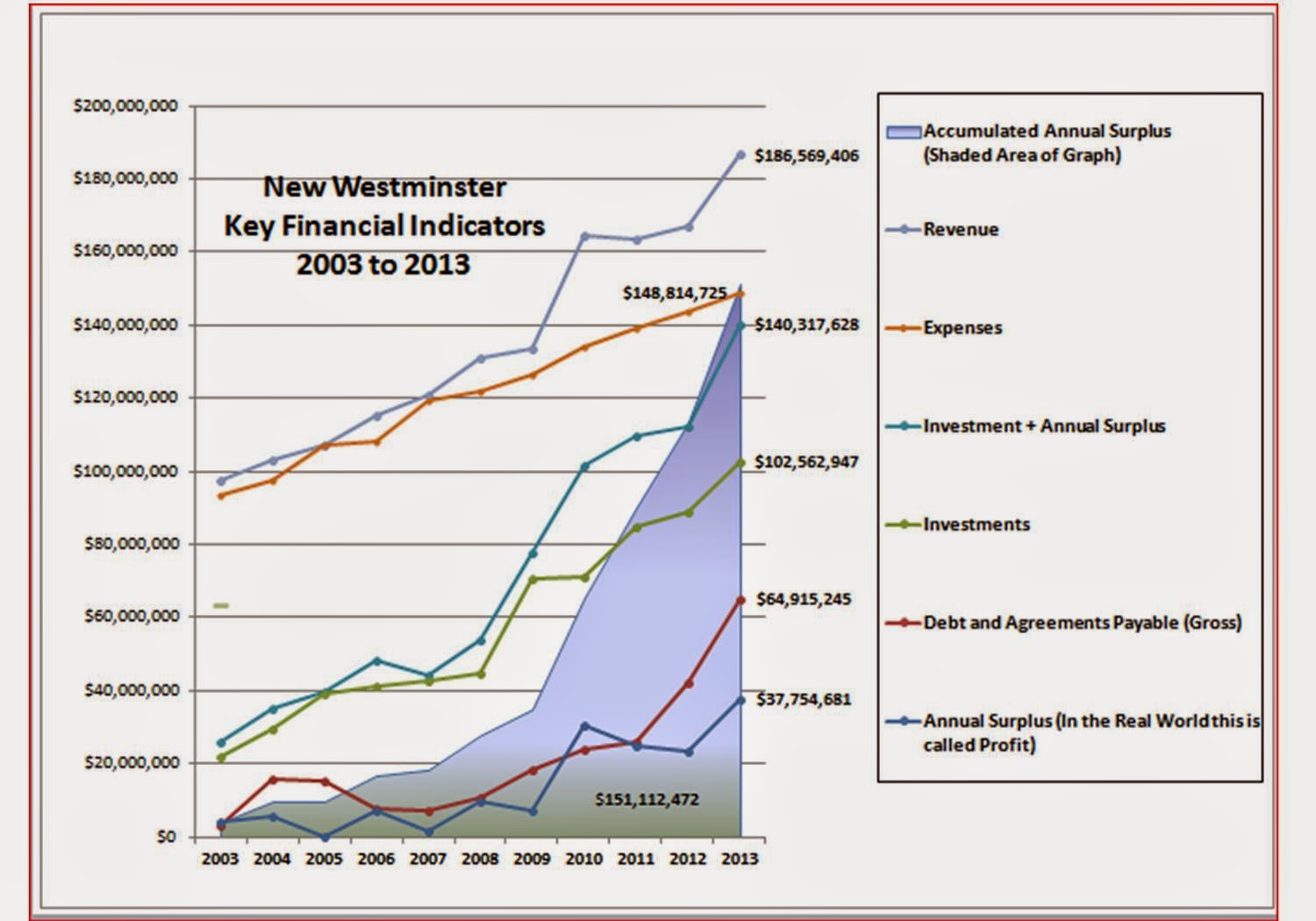
It has been a while since campaign financial disclosures from the 2014 municipal elections were released. I apologize it took so long for me to write this up, but I haven’t had a lot of time to crunch the data. After giving the CTF the gears for their ham-fisted disclosure, the least I can do is point an equally critical eye at my own disclosure forms, and those of the other candidates in the election. Do they support the common narrative of the campaign that we all held last fall?
I should note right off the top that the numbers below are off the unaudited forms as submitted to Elections BC. They have not yet been reviewed by Elections BC, and may contain honest (or otherwise) errors that may impact my analysis. I have not gone through every form (except my own) in any detail, and take the declarations people made at face value. Note, the first error I noticed was on my own form (!), where an extra digit was slipped into line 10 of form 4222, such that it doesn’t match box A of form 4234. The entry on Form 4234 is correct, and the error on 4222 is an obvious transcription error. My Financial Agent contacted Elections BC to let them know as soon as we noticed this. So in the interests of pots and kettles, I’m not going to point out the math errors I note on the forms of others.
Because I am so involved in this, I am going to first concentrate on the details of my own form in this blog post, and will discuss the entire council campaign a little further down. Mayors and School Trustees can take care of themselves!
The first headline is that I spent more than anyone else running for council this time around. If you had told me that a year ago, I would have been surprised, but that surprise would have steadily decreased as the election rolled on. (Of course, I had I known, I might have spent $200 less, and got in under Councillor McEvoy’s total, but hindsight is 20:20). The reason things changed during the campaign was the emergent generosity of people from across the City (and a few from outside of it) who personally contributed to my campaign. This generosity was humbling. I talked in this earlier post about what I think went well and didn’t go so well in my campaign, and fundraising was clearly a success.
When I went into this project, I knew I would need to spend a lot of money to “break the bubble” and get my name out into the community to people who didn’t know me. I had a base level of name recognition, but that needed to be boosted by an order of magnitude if I was going to be successful. Between my core team and I, we set out a preliminary budget of $15,000. Being a member of CUPE, I figured I could count on $3,000 from them, and if I received endorsement from the NWDLC, that estimate would rise to $5000. So I set a non-labour fundraising goal of $10,000 (not including in-kind donations). By the end of the campaign, those goals were met, and exceeded.
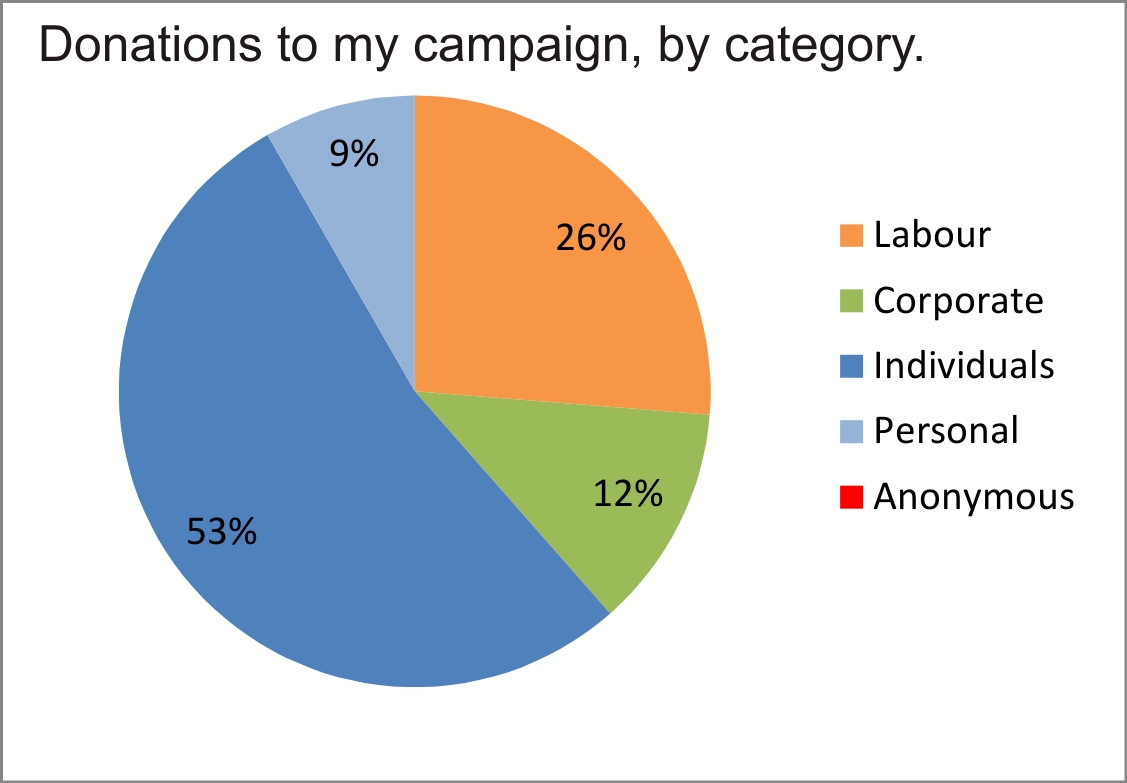
I received almost $3000 in donations from companies (representing 12% of my total). About $1,200 of that was “in kind” donations, such as discounted web services from a friend who runs a server, and donations from local businesses that were used as door prizes for my fundraiser. An interesting issue with the door prizes are that they do (by the rules) constitute an in-kind donation, and were declared as such, but according to the instructions we received from Elections BC, they are not counted as a fundraiser expense when they are given away. That donation-without-an-offsetting-expense accounts for a large part of the gap between the money I raised and the money I spent.
The amount of money I received from various labour organizations amounted to $6,300, (26% of the total) of which $5,800 was cash and the rest was in-kind donations (essentially, use of some of their services).
That means the rest of the money (62%) was from private donors- about $3,000 in the form of Fundraiser tickets, and the remaining $10,000 in declared personal donations (plus the $2,000 I put in personally, some of which was refunded at the end to close the bank account). I received no anonymous donations (which are illegal over the amount of $50). Here is a pie:
As I said earlier, I had the highest declared expenditure of any Council candidate, beating last election’s champ by $200 (but spending much less than he did last election). Here is a chart that shows how much every candidate raised, broken up by the category of fundraising, and listed left to right in order of number of votes received. You might want to click to get the details.
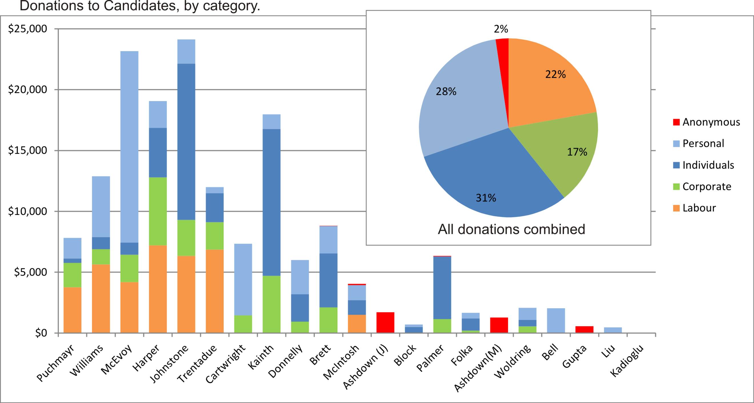
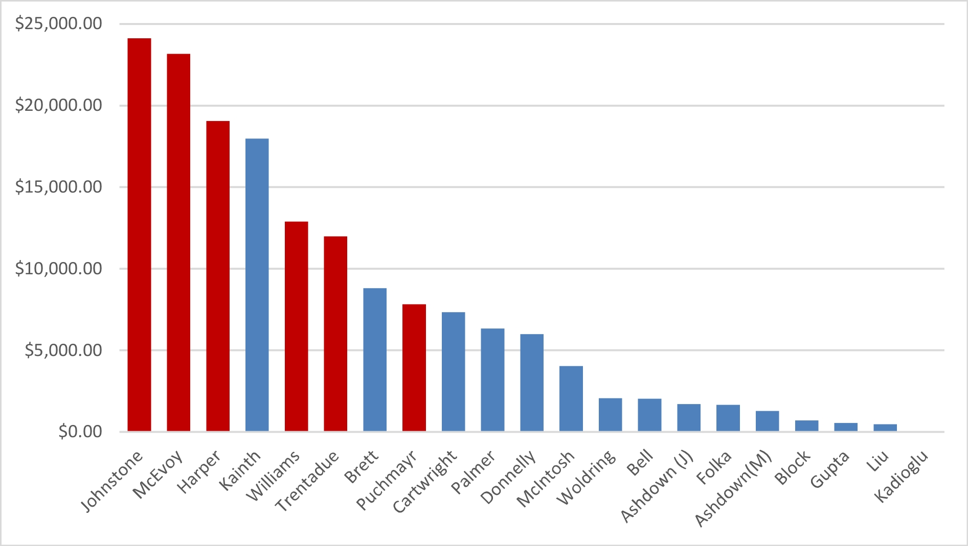
Of the 6 elected people, 5 were amongst the highest spenders/fundraisers in the election. Both Kainth and Brett spent more in losing causes than first-finisher Puchmayr did (demonstrating the power of incumbency and name recognition?). A fairer division might be to split up into “big spenders” (myself, McEvoy, Harper and Kainth), “semi-big spenders” (Williams, Trentadue), and “serious spenders” (Puchmayr, Cartwright, Donnelly, Brett, and Palmer). People who spent less than $5,000 getting their names out there did not fare that well. Money doesn’t buy elections, but it sure buys attention, and you need attention to separate you name from the other 20 on the ballot. On this chart, people are in the order of spending, not the order of votes (red columns are those who got elected):
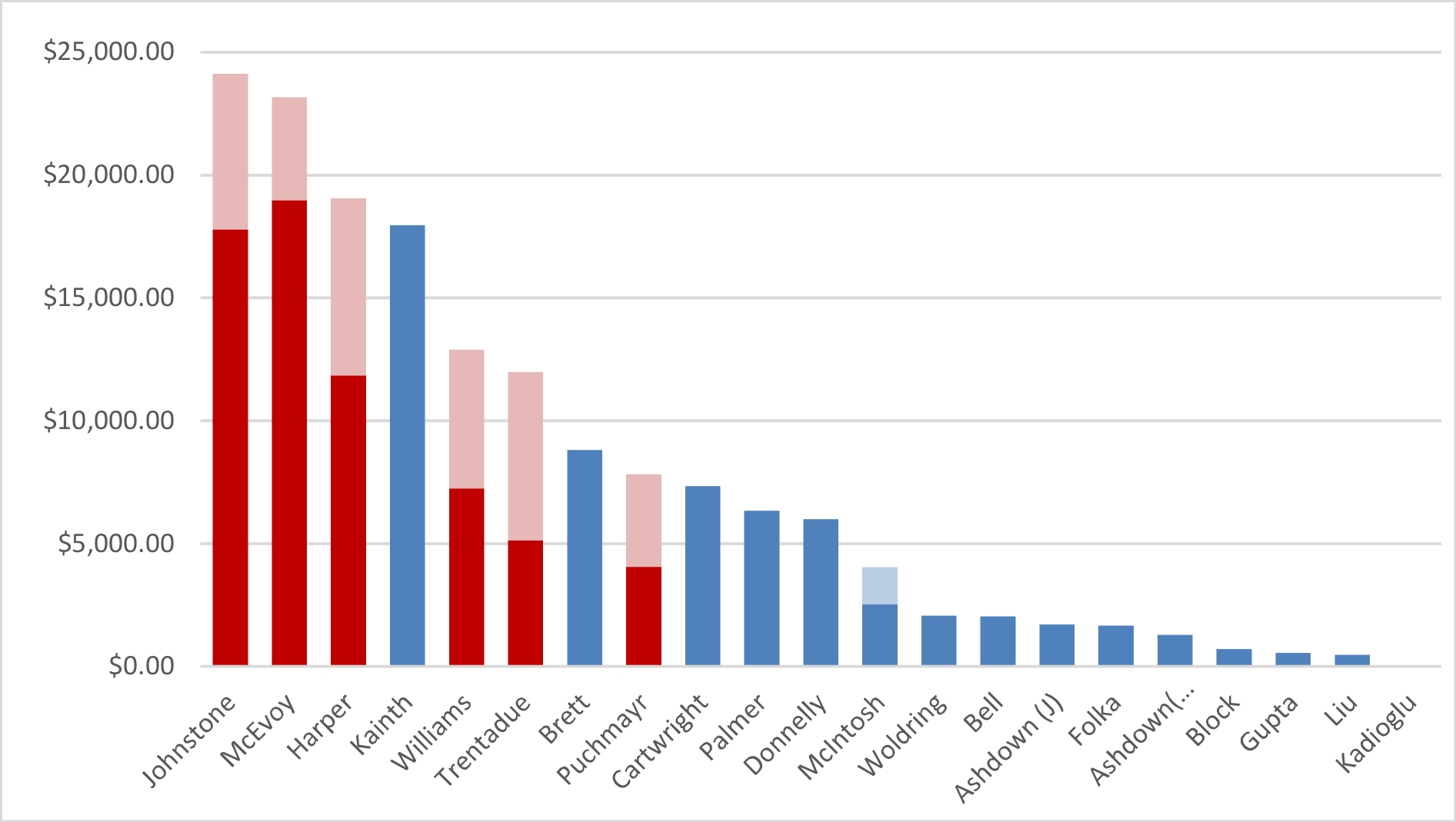
“Labour Money” was clearly a factor in fundraising, representing about 22% of all the money raised in this election (recognizing, again, that much of that is not actual money but “in kind” donations), divided between the 6 NWDLC-endorsed candidates and CUPE member Scott McIntosh. This chart changes the one above by shading out the “labour” contributions, to see the subtle changes in how the campaign would be funded with out it:
Back to the multi-colour chart, Corporate/business donations (in green) did not quite meet the level of labour, totalling 17% of all money raised (again some of this will be “in-kind”) with Harper and Kainth as stand-out recipients. I was the third-highest candidate when it came to corporate donations.
Where I clearly led the pack was in individual donations from private citizens (in blue), with Kainth just behind me. I attribute this to my early start (I was the first candidate out of the gate) and a really stellar effort by my fundraising team to put together a fundraising event that got people excited about the campaign at the right time. I understand Kainth also has a great launch party, and with her deep connections in the business and social community on New West, I’m not surprised she also did this very well. Note that I separated personal donations (the money candidates contributed to their own campaign) from other individual donations, by shade of blue.
Also interesting is that more that 61% of the money raised this campaign, and approximately 50% of that raised by the winning 6 candidates, was private individual donations. I for one would not oppose limits on labour and business donations in local elections, but only if private donations also come with strict upper limits. Unless taxpayers are expected to foot the bill for all election financing (and I don’t suggest they should), if we remove the right of organizations to contribute (through cash or in-kind help), it is inevitable that campaigns will be funded by the wealthier demographic with disposable income, which will no doubt shift how policy is developed on the ground. Tax credits as they exist in senior government elections (and tax credits for volunteer work for lower-income people) would help flatten that disparity.
Finally, I’m not afraid to say that more than $20,000 is a slightly absurd amount of money to spend running for City Council in New Westminster. I would welcome discussions on placing limits to spending, but will not lead that conversation for a good reason. As this election proved, incumbency is a huge advantage, and advertising is more important to challengers than it is to incumbents. For me, who used a lot of money to establish name recognition, to now limit that right for those who would challenge my incumbency in the next election may be politically smart, but not terribly ethical. If a person is able to raise a lot of money from individual donors across the City, if they can raise that groundswell of support for the democratic process, then I suppose we should not discourage that.
Every indication is that things are going to change in the next election. ElectionsBC made some changes going into this election, and the provincial government has hinted at campaign financing limits next election. Expect there to be public engagement during the development of the new rules, so you should keep an eye on the ElectionsBC website if you really care about this issue.