What do you think of the news that B.C. prepares to remove some housing approval powers from local governments? There are no denying that getting permits from a city is slow and difficult. I’m not sure whether take powers away from local government is good or bad, but in your opinion, how New Westminster can do better on issuing new permits?
I have been thinking a lot about it, but I don’t yet have any answers. This is mostly because Minister Eby has been rather vague about what types of changes he is looking to implement, and the target needs to be well understood to avoid unintended effects. I’ll try to unpack what doesn’t fit in the headlines.
First, I need to note my comments are from the point of view of a member of a City Councils that is meeting our regionally-agreed-upon commitments to building new housing. We have leadership and staff that have weathered the challenges of meeting our Regional Growth Strategy obligations in approving new Purpose Built Rental, market housing, and family friendly housing, while we are finally cracking the nut on new “missing middle”. We have not just approved new non-market affordable housing, but have made City lands available and fast-tracked approvals to assure that when funding arrives for non-market housing, we are inviting it in, and we have made clear we want more funded in our own back yard. We did this without massive expansion into greenfield (because as a 150+ year old City, we don’t have much greenfield) and without massive displacement of vulnerable residents from the older, most affordable housing in the City.
That is not to say New Westminster doesn’t have more work to do, or that the crises are over, only to note that the work we have done in the last decade is region-leading (if the City of North Van will share the podium). This work has not been without push-back from some of the community. Every day we hear as much from people telling us we are going too far, too fast, as we do from people asking us what we are doing to address housing. Have you looked at Facebook recently?
At the same time, we are a City of just under 80,000 people in a region headed towards 3 Million. With only 3% of the region’s population, less than 3% of its tax revenue, and much less than 1% of its land area, New Westminster is not going to fix the regional housing crisis. The region is thousands of units a year short of approving what is needed to start to stabilize the market, and are thousands of non-market units short of what we need to provide stability to the most vulnerable populations. So when facing push back or predatory delay, I can see why the Minister responsible for Housing is getting hot under the collar, and is ready to start swinging a big stick to get municipalities to do their job.
Without the benefit of more detail about what that stick looks like, I am concerned that the perception being created (as it may not be what he intends, only the way he is being interpreted in the media) is that of threats, and I can only hope from the New West perspective that Minister Eby will find carrots to compliment that stick.
People in New West know what we need to help the new housing find broader public support in the community; we know what those carrots are. Clear financing for new school locations; support for transit and funding for active transportation to reduce the traffic loads new growth would bring without those investments; prioritizing existing infrastructure funds supporting everything from sewer upgrades to library expansions to new park space, so communities meeting their regional commitments have the upper hand in grant applications. And, yeah, legislative tools to give well-meaning Municipal Councils and staff the flexibility to approve good projects faster.
How can we do better on issuing new permits? The question is really wide-reaching, so the best answer is equally far-reaching. If the conceit of your question is that New West is not building fast enough (and I’m not convinced your entire community agrees with you there) then there is work we can do to accelerate the process. I have had long conversations with architects designing new apartment buildings to homeowners doing relatively small infill projects, and there is no doubt they feel there are approval steps or consultation standards that are not obvious in why they are needed. Developers will tell you this extra time costs them money and pushes up prices, but accelerating the process may cost the City money (as we would need more staff), or compromise important policy goals, so there is clearly a balance to be found. I think the best shorter-term improvement is in creating more certainty about the time for approvals. But again, Development is complex, and we have a culture of public engagement in New West that is difficult to rush.
The one assumption to put aside, however, is that the Province can meaningfully force an acceleration of these processes. Unless the province removes from Municipalities the one ultimate authority they hold – zoning – it will be wielded by different Municipalities to achieve the policy and political goals of the community. And, alas, constructive delay of change is a policy goal of some local governments. As a Lawyer, Minister Eby certainly understands that removing zoning power opens a Pandora’s Box of problems, because zoning authority is interwoven with local government and provincial government regulations. A single example I am professionally very familiar with: without local government zoning control, the entire provincial contaminated sites identification and management system will have to be redesigned. There are scores of other Provincial and Municipal regulatory systems that are similarly buttressed by zoning. Unpacking that would be a very difficult process.
That is not to say the Province is powerless, far from it. I think that Minister Eby will need to be surgical and strategic about the sticks he wields, though I would not begrudge him wielding it to get our region back on track to addressing our overlapping housing crises. I only hope he also brings those carrots, because local governments need community support to do good work, and long-term benefits of meeting our regional commitments to housing are becoming a harder sell to the comfortably housed who vote.
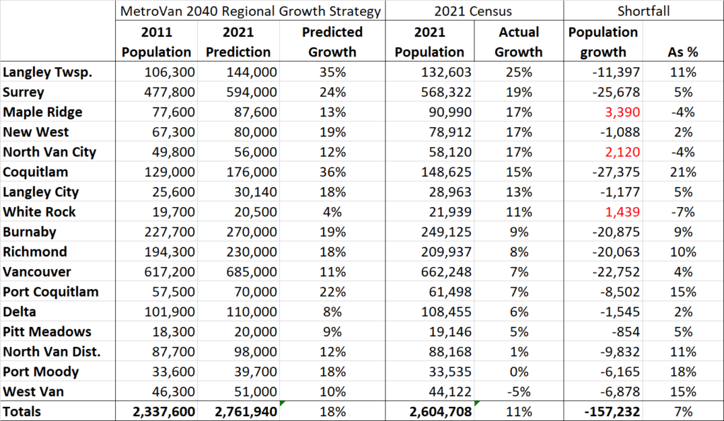
The 2021 census data is starting to trickle out. The first release of data is on population and housing, which is obviously a hot topic in the Lower Mainland. This means there are a lot of news stories about what has changed since last census in 2016. However, because of the work I do, I prefer to look at the change over the full decade since 2011. This is because 2011 was the “baseline” population level that the 2040 Regional Growth Strategy for Greater Vancouver is pegged. Since every municipal Official Community Plan was developed in context of the 2040 RGA, and since we are currently updating to a new 2050 RGS, I thought it would be good to re-look at Greater Vancouver population change in comparison to the RGS with the new census data.
Regular readers (Hi Mom!) might remember me doing something like this last year with the 2020 Stats Can population estimates. As it turns out, actual counts are more accurate than estimates*EDIT – see below*, and an update is required. Here is the table of Municipalities with 2021 Census population sorted by the rate of growth since the 2011 Population used for the Regional Growth Strategy (yes, I excluded the minor Municipalities like Anmore and Electoral Area A, for simplicity, laziness, and because I can).
Where to start? Overall, the region (excepting those small Munis ignored above) grew by an overall 11% over that decade, falling far short of the predicted growth of 18%. This means there are at least 157,000 fewer people living the in Greater Vancouver than expected. Only three Municipalities added more population than the RGS expected: Maple Ridge, the City of North Vancouver and White Rock. That last one might be a surprise, but remember White Rock had the lowest predicted growth over the decade, and so their growth being on par with the regional average put it way above what was expected.
Note that North Vancouver District and Port Moody have essentially not changed in population over the last decade (though found two very different political pathways to this lack of change) and West Vancouver lost population. The overall result is that every region of greater Vancouver fell short of the predictions, excepting the Northeast corner of the regional district.
The story locally is that New West also surprisingly fell short of the RGS goals, though only by a small amount. Nonetheless our 17% growth rate was one of the fastest rates in the region. This is perhaps more remarkable when you note the only Municipalities growing at a faster rate happen to be the 3 easternmost ones – those with the greatest access to greenfield into which to sprawl.
Which bring us to the other New Westminster headline of this census release: New Westminster being touted as the major municipality with the second highest density in Canada. This is interesting, but I may argue this is a bit of an artifact of the data and political jurisdictions.
We are surely a dense urban community, which is a natural result of being the nucleus of a rapidly growing urban area for more than 150 years. Our footprint is compact (under 16 square kilometers) and we don’t have farms or large undeveloped areas of forest, having chopped most of those down about 150 years ago. Our urban form was mostly established before the automobile era, and was not extensively re-drawn with Motordom.
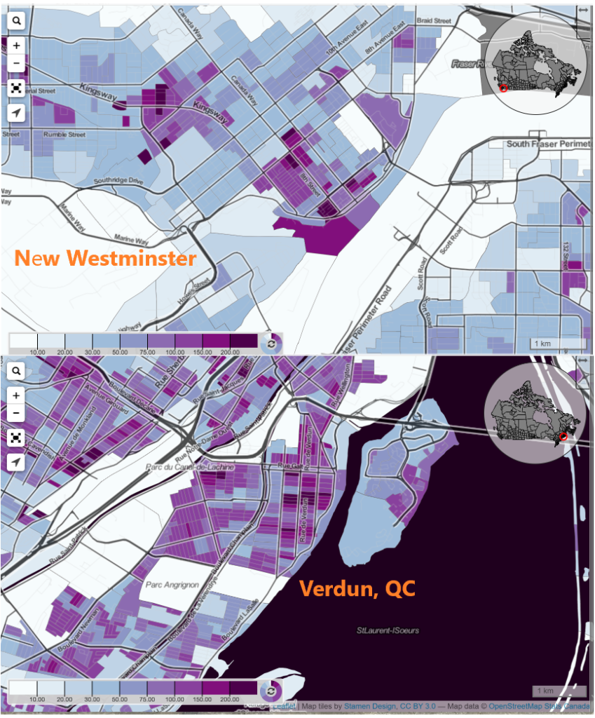
However, this does not make us that different from many older urban areas of Canada. But in looking at the data, we need to remember that satellite centres of Toronto or Montreal are amalgamated into one larger municipality. Shown at the same scale using Censusmapper.ca and population density data, it doesn’t immediately appear that New West (as a 79K population commuter suburb of Vancouver) is much denser than, say, the arguably comparable (population 72K commuter suburb of Montreal) neighbourhood of Verdun.
I’m not ready yet to say what it all means, as there is more data and mapping to come out. However, New Westminster is part of a region facing a long-standing housing availability crisis, and more acute housing affordability crisis. We may be bringing on supply as fast as anyone in the region (and faster than most) but at 79,000 people, we are still only 3% of the region’s population, and addressing the supply crunch is going to take more than New West can do alone. We need more action across the region.
At the same time, I am proud to say that New West is bringing in not just supply, but a diverse type of supply. Market condos are meeting the region’s most aggressive Family Friendly Housing policies. We are approving more Purpose Built Rental than we have in decades, and we have truly affordable housing options being built across the City as fast as the funding for these units becomes available. Though the value of land has shifted regionally past where rowhomes and townhouses represent “affordability” for most families, we are starting to see a big uptake on this type of build in traditionally Single Family parts of the City, and this long-standing gap in supply is finally being filled. We are also bringing this supply on while protecting the more affordable housing in the City, for the most part avoiding the mass displacement of people from existing lower-cost housing through strong policy. We have a lot of work to do, but we are on the right track.
*EDIT *: TIL: I’m completely wrong on this point. Census population estimates may actually be a more accurate count of the number of residents living in a municipality, because they account for the way the census systematically undercounts. Read more here, if you care. Fascinating!
I finally had a little time to condense down a bunch of thoughts and notes about the Opening Doors report that was delivered to the Provincial Government last year. I read the report when it came out last summer, and noted how it landed in an overstuffed news cycle to be almost ignored by anyone who wasn’t already a housing wonk. I might have winged a bit on line at the time, but I was not overall as critical as some of my neighbours across Tenth Ave.
Last month we held a Workshop at New West Council to talk through the report recommendations with staff support, and prepare a more formal response to the provincial government (you can watch a video of that meeting here and see the report and presentation City Staff prepared to inform that workshop here). This brings me to my regular warning that the comments that follow are mine, not the official position of New Westminster City Council or anyone else, and you might want to watch that video to see some of the more nuanced discussion other Councilors brought to the discussion.
The report needs to be put into the context of how and why it was created. It was an Expert Panel put together to provide advice to the BC and Federal Governments (delivered to the respective Ministers of Finance, notably) so it weighs heavily on things senior government can do. The Experts on the Expert Panel were, perhaps shockingly, bereft of municipal experience, and their decided expertise in finance and property development resulted in their firm application of Maslow’s Hammer. I also chagrin that the progressive *economic* quick wins proposed were the only part of the report that the senior government Ministers of Finance rushed to make comment on – and that was just to say no to them at the moment they were proposed.
But I’m already getting ahead of myself. Let’s look through the major policy directions proposed, from the municipal perspective. There were 5 major themes, and 23 recommendations, and you can read through them all if you like, but much like the conversation we had at the Council workshop, I’m going to summarize by order of government, because we all have work to do to address what is a national crisis at this point.
Things the Feds can do:
The roots of our current homelessness crisis are found in the early 1990s when Paul Martin looked at the comparatively modest housing cuts under a decade of Mulroney, and decided he could do better. The 1994 Martin budget got the federal government right out of the business of building housing. When a rapidly growing and urbanizing country like Canada goes from building 15,000-20,000 social housing units a year to less than 1,000 there are going to be devastating effects. And here we are.
So, with the Feds having the, by far, deepest pockets, it is not surprising that the one thing the Feds could do first is start using those funds to build housing. To quote directly:
the federal government make long-term funding commitments, as was done until the mid-1990s, rather than offering short-term capital grants. We recommend that the scale of these funding commitments reflects what is required for the construction of new social housing units to return to historic levels, when nearly 10% of all national housing starts were social housing units
There are also great recommendations here about making Federal Lands available for housing in high-demand communities, giving the non-profit housing sector more tax incentives, harmonizing programs that may speed housing being brought on-line (like federal/provincial/municipal building codes, fire codes, energy efficiency codes, etc.). But, still, someone has to pay for the housing that the market is not going to provide.
There is also a recommendation around incentives that stands out to me:
federal and provincial governments create a municipal housing incentive program rewarding the creation of net new housing supply wherever demand occurs… their primary purpose is to recognize municipal costs incurred in growing the housing stock and reward growth of housing supply where it is needed.
This addresses straight-on a significant downloading concern all Cities have in investing in affordable housing. Given an historic lack in Federal and Provincial funding (only beginning to be abated now), creative cities looking to be proactive have tried to leverage local powers to get housing funded. This means directly spending on housing, giving our limited land base up to affordable housing projects, or leveraging affordable housing as a community amenity attached to new market housing. This last one definitely has populist appeal, because it makes people feel we are making the “greedy developers” pay for it, but the reality is we are simply taking money that would have otherwise been used to pay for other community amenities – parks and recreation centers and libraries – and as we dip into those resources, we lose public support for growth, because we cannot provide amenities that assure a denser City is livable and full-service.
So this recommendation seems to suggest that Cities that meet housing growth targets are prioritized for federal funding. I actually hoped it would go a little further and suggest that federal infrastructure granting programs like ICIP should specifically hinge on high-demand communities like New Westminster meeting their housing targets.
Things the Province can do:
When Martin/Chretien gutted federal funding for housing in the early 1990’s, BC stayed in the business of building housing for another decade or so, until the Liberal Government of Gordon Campbell put an end to that in 2002. Though programs are now coming back in a meaningful way, we are left with a big gap of 20 years of underbuilding to our needs.
All of the points above about what the Feds can do also apply to the Province – they can provide funds, land, and incentives. Though their pool of funds is somewhat smaller, they are in the right place to note and be proactive about regional needs, and indeed the money saved by giving people safe, secure homes comes right back to the Province through savings in health care and other social support spending.
One aspect of this that is somewhat missed in the panel report is the opportunity for the Province to get back into the business of supportive housing. By the current model, the Province may provide funding to private developers to include affordable housing in their market housing proposals and/or provide funding for the not-for-profit sector to deliver and operate the housing. This is based on the neoliberal idea that government saves money by paying someone else to do something instead of doing it themselves. This is the model that brought us disastrous results when a pandemic hit the care home sector, and a model we still somewhat resist for healthcare. But this is still an operating assumption for housing that adds complication and uncertainty to the delivery of housing, and makes it harder to get housing built.
This report skates around the demand side of the equation. I know this is a politically charged discussion in a growing country with ambitious population and economic growth models, and I am not going to delve into the fanciful economics of a certain UBC landscape architect or the xenophobic ravings of familiar populists. Instead, I would suggest the place where demand management comes in is the federal and provincial taxation structures that reward the commodification of housing, while at the same time providing no benefit to renters or those who are unhoused. For whatever reasons these various structures (homeowner tax credits, capital gains exemptions for housing, etc.) were developed years and decades ago to encourage people to buy and stay in houses, they no doubt provide a perverse incentive during a housing crisis where most cannot afford the ticket to entry while taking hundreds of millions of dollars out of the government’s coffers that could be better applied to providing housing to those in need. This is the part of the Expert Panel Report that senior governments rushed to say they were not going to enact. See recommendations 21 and 23:
21.…make changes to tax programs to bring the treatment of renters and homeowners into closer alignment. This would include reviewing the impact of the capital gains tax exemption on principal residences… and extending comparable support to other forms of wealth building; 23. …phase out the Home Owner Grant. Monies saved from this should be used to fund social housing in addition to the commitments made in the 10-year plan.
Alas, the Culture of Contentment assures that no government, no matter how progressive their campaign, will be willing to address this disparity any time soon.
Another important piece missing from this report is the need to protect renters and keep people from becoming homeless in the first place. Again, the Province has made tentative steps in the right direction here, but is not where the City of New Westminster and other local governments have been asking them to be in stopping renovictions and demovictions.
Things for Local Gov’t to do?
I’m going to mix together our Regional and Local government parts here, and only note that the Expert Panel Report skips regional government altogether, though they are a significant provider of affordable housing in the Lower Mainland and other regions of the province. They are also the level of government that sets regional land use and housing policy, but we’ll get to that.
The part to remember is that this is a report to senior governments, and the question here is more “what can senior governments to do to either compel or make local governments approve more housing faster?”. This might sounds strange to many in New West, where we are meeting (and slightly exceeding) our regional growth strategy targets for housing, rental and affordable housing, and population growth. If anything, I feel people are starting to feel a bit of growth fatigue related to construction impacts. However, we are one of the few municipalities hitting these targets (as I talked about at length here), and housing demand is still far outstripping availability – so what can the province do to get those other municipalities to keep up?
Right off the bat, we know the first recommendation doesn’t work:
the B.C. government impose statutory time limits to all stages of the property development process, municipal or other, for all types of development. Similar limits imposed in Ontario and Alberta can serve as examples
Putting an artificial timeline of, say 90 days on a Rezoning application as Ontario did, fixes nothing. The arbitrary nature of the limit belies the complexity of many rezonings, ignores that even the Province cannot commit to providing referrals within that time limit (in the case of EMA freeze-and-release provisions, or MOTI approval for development near highways as only two examples), effectively undermines the ability for an elected Council to do what the Community elects them to do. It reduces a local government’s ability to evaluate and benefit from land lift related to rezoning, and undermines any principle of meaningful community engagement over development. The net effect is that most rezoning applications would be turned down, not that most would get approved faster. It does this all while adding a new layer of bureaucracy – the tribunal through which applications not meeting timeline could be appealed.
Fortunately, more of the recommendations around introducing “affordability adjustments” to the Housing Needs Reports, aligning our OCP updates with these needs reports, provincial streamlining of development permitting processes province-wide and the such, are doable, reasonable, and would likely have wide-spread buy-in by municipalities, though they may take some work on behalf of all parties.
An identified theme is that Municipal and regional housing targets actually have to come with some force. We are dealing with a regional problem, and need to solve it regionally. There are a variety of sticks and carrots the Provincial Government can apply, and a lot of funding incentives for infrastructure to better support the pressures cities face as they densify. Indeed, changing how the province incentivizes growth would also result in significant greenhouse gas reductions and reductions in the cost of many different forms of service delivery. There is a big win in here, but it would require some political courage to step into what local governments (and regional governments) see as their turf. When half the mayors in the region are elected on straight-up or veiled promises to curb growth, political battles would no doubt ensue, but a crisis like this does not allow half of the region to say “not our problem” as has been the reality for a decade. They know who they are.
There are two aspects of how Cities approve housing that the Provincial government can definitely influence, as they are regulated at least in part but Provincial regulations: how Cities finance growth, and how our permitting programs work.
On the financing side, the report includes this recommendation:
conduct a full review of local government revenue sources and spending responsibilities… includ[ing] consideration of additional or enhanced funding sources for infrastructure and amenities that are more predictable and do not rely on rezoning or the development process. Preference should be given to means that capture land value through taxation, rather than homebuilding
To frame this a bit, Municipal governments collect Development Cost Charges (“DCCs”) on new growth, Voluntary/Community Amenity Contributions (“VACs” or “CACs”), and a whole raft of different fees and changes on development. It’s a bit of a complex mess, and outside of DCCs, not particularly well regulated. This creates not just cost, but uncertainty and complexity for builders and great variances across the province and region. One recommendation would be for the Province to clean some of this up. perhaps by expanding the DCC program to make it more flexible and reduce the reliance on VACs/CACs. This sounds easy, but is actually something that would have to be addressed with great care, as the balance between community and private benefit from growth (never mind the public perception of that balance) is precarious and dynamic, and Mencken warned us about seemingly simple fixes to dynamic human problems.
The second aspect of change could be in the permitting processes themselves. Given the financing issue is managed (see above),then strategic pre-zoning takes a lot of risk away from builders, and reduces the time taken to get from planning to occupancy. This type of strategic pre-zoning probably doesn’t want to occur until we have a funding model established to assure the community knows it is getting its share of the inevitable land lift (and Cities have a way to fund the parks, playgrounds, roads, theatres and libraries that make the community livable), and stricter and clearer design control is in place, as the City will functionally be ceding much of that control when it gives away zoning. There are incremental changes Cities can make in the short term (like New West, where we have given Development Permit authority to staff without an extra trip to Council), but some major shifts in the permitting process that are recommended (like reforming the problematic Public Hearing) would require changes to provincial legislation.
The summary
We have a housing affordability crisis because we are not building enough homes to meet demand. We have a homelessness crisis because we are not building enough non-market and supportive housing to provide appropriate shelter for people who are forced out of the bottom of the market as prices rise. These are two overlapping crises that require parallel approaches to fix.
The first problem is related to a complex mix of jurisdictional and political roadblocks, some easier to overcome than others, but even with the existing legislative framework and tax structure, municipalities can build to meet demand now. some of us are. If the Regional Growth Strategy is any guide, Municipalities like the City of North Vancouver and New West have shown that the solutions are available, but some municipalities simply don’t want to take part. We need to level that playing field.
The second problem is much easier to solve. Build housing for people who cannot afford to be in the market, like this country and this province did in the decades between WW2 and Mulroney/Chretien austerity, or as the Baby Boom generation calls them, the Good Old Days. Fortunately, this easier-to-solve problem can go first, and even the most reluctant local government can’t stop it if the senior governments are committed to fixing it. As a bonus, it takes the pressure off of the harder to solve supply/demand problem of market housing. But to solve that second problem, we first need senior governments to be more honest about the goals of our economic policies, while local governments need to be more honest about whether they actually want to solve the problem.
This report, for its strengths and weaknesses, could open doors to some of those more truthful conversations.
Hi Pat – Looking forward to the AAA bike network coming to NW in the next 5 years. I’m looking into an e-cargo bike for our family but my biggest blocker is bike storage. I live in a building over 50 years old that does not have secure bike storage (but I have 2 parking spots that I don’t use since we don’t have a vehicle…). Wondering if there’s anything that the city of New West can do to incent existing stratas to invest in better secure bike parking? Or allow owners to convert their parking stall into secure bike parking without having to get approvals? On a related note I also wanted to see if there were any plans to convert on street car parking spaces to secured bike parking/storage? Even if this was a paid service that would be something hugely beneficial to us.
Oh, boy, you got me writing about bicycles. Better put on a pot of tea.
If we can get Council to commit to completing the AAA network, End of Trip facilities (EOT) are clearly the next big infrastructure challenge when it comes to supporting active transportation. With the shifts in the types of devices people are using, it is clear that even the best plans of a few years ago are not going to be sufficient if we really want a wider mode shift in the community. So let’s go through a few of the new challenges, and how a Local Government can help solve them.
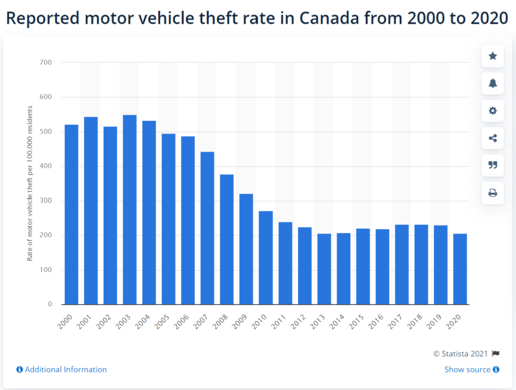
Bike theft is currently a huge problem regionally, in a way that car theft was 20 years ago. I seriously doubt that our Motordom-entrenched law enforcement and insurance agencies are going to get as proactive in battling bike theft, so the arms race of tougher locks and more secure storage options are really our only option.
Bike storage at home is another area where multi-family needs a different approach than the single family detached home. Bike rooms in the traditional sense are a basement room with a few racks, mostly filled with dust-accumulating Canadian Tire specials with two flat tires, hard to access, not particularly secure, and really inconvenient to use. Meanwhile, apartments are not built large enough to store a couple of bikes, and random Strata or Rental rules inexplicably restrict bicycles in hallways and elevators.
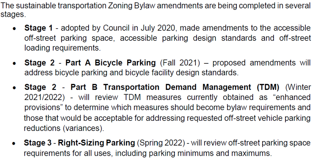
As with many other structural changes in housing, we can do more about new housing than the existing housing stock, so the City is able to create new standards for Bike Storage rooms, like New West did a few months ago. The City is currently making a suite of changes to the Zoning Bylaw to make sure our Zoning requirements align with our transportation goals. We can do this through zoning because of the exceptional powers zoning gives local governments, and that includes adding “red tape” like this. Here is the plan for the current changes (from the October 18 Council report):
In November, we adopted the Stage 2 Bylaw changes that make bike parking locations as convenient as possible for users, improve security given cost of e-bikes and other non-conventional bikes, ensure oversized (e.g., cargo) bike sizes are better accommodated in new housing.
Of course, that does nothing for the existing building stock, and the City has really limited powers here. Bike rooms in the traditional sense don’t work- not big enough, not secure enough. Getting a strata or rental company to invest in making them function better is a really, really hard. Stratas have a lot of power, provided by the Province, to set their own Bylaws. It is difficult for a City to enforce in that space, and I honestly don’t know if the City could force a Strata to provide better accommodation to cycle storage, you need to take that up with your Strata Council. Though the City has recently had some success using our business regulation powers to change how rental property owners operate (to prevent unnecessary renoviction), It was a challenge, and I’m not sure the City is going to push that leverage to regulate bike storage rooms.
Storage in underground parking also presents security challenges, and similarly runs up against Strata or rental bylaws. I have even heard (anecdotally) of the Fire Department recommending against storage of stuff in general (and cycles as a subset of “stuff”) in underground parking garages during fire inspections, though it would be difficult to argue that the most flammable bicycle (I’m looking at you, Vitus Carbone) presents less of a fire risk than the most modest automobile fuel tank. However, if we put aside how to get there, I think the most affordable and secure solution for most of the exiting building stock is secure bike lockers in existing underground parking garages.
As far as incentives? The City is pretty limited by the Community Charter as far as giving financial or tax incentives to individual Stratas or rental companies that would encourage them to provide better storage solutions, but perhaps the best we can do is get out of their way if they want to take this path, such as allowing them to reduce the amount of parking they have on site if they convert that space to cycle storage options. Though I would argue incentives to Stratas willing to invest in secure cycle parking is a better idea and more equitable than investing in incentives for individual bicycles like some communities are piloting.
Creating better public short-term storage solutions is also something the City can do. Some of our Parklets have attached cycling parking, and that is definitely something we can do more of as we work on Bold Steps 2 and 7 in our Climate Action Plan. I’d also love to see more the bike locker type storage that TransLink has been doing for years, where the security of storage problem is fixed, even if their lockers don’t really work for your cargo bike types.
Finally, bike share solves part of this problem. The North Shore communities got ahead of us on this pilot program, but we are watching closely how it works out. E-bike share reduces the need for people to invest in expensive and hard-to-secure vehicles, and allows them to instead spend a few dollars a trip on the most common type of e-bike trip – a kilometer or two to a relatively nearby rapid transit or shopping destination. New West is uniquely located along a heavily used transit line, with hills separating much of our community from it, and a high enough multi-family housing density to make a program like this work.
But all of this also relies on us getting that AAA network built so more people feel safe using these devices. This needs to be baked into our 5-year financial plan, similar to how Victoria got their network build over the last few years. Shifting how we move around to meet our livability and climate goals will rely on both of these.
Curious to know where the city is at with it’s tree planting roll out for street trees. Sapperton residents would appreciate and benefit from some shade. I live on Simpson and have been asking for street trees for 5 years. Many thanks
Short answer: As far as I can tell, New Westminster is on pace, or slightly ahead of pace, on the tree planning strategy approved in 2020, and the good news is that Simpson Street is a high-priority street for planting, so you should hopefully see new street trees in the next year or so.
The City is planting a lot of trees. This followed on a few years of working on an Urban Forest Management Strategy that is one of the things I am most proud of during my time on Council. After decades of a slowly eroding tree canopy, the City committed in 2016 to turning that tide, and going from 18% forest cover (measured in 2014) to 27% cover by 2035.
A 9% increase in tree cover might not sound like a lot, but it would require an additional 8,500 trees planted on public lands and 3,300 trees planted on private lands. That means more than 800 new trees a year, not including the trees we needed to replace any lost through development and natural tree death. There are four strategies to get there: A proactive Tree Bylaw to protect as best we can healthy mature trees on private property; incentivizing private tree plantings through tree sales and promotion; investing in urban reforestation where opportunities arise such as parklands; and committing to an aggressive Street Tree planting program. The last two of these are supported by our 2020-2030 Tree Planting Master Plan.
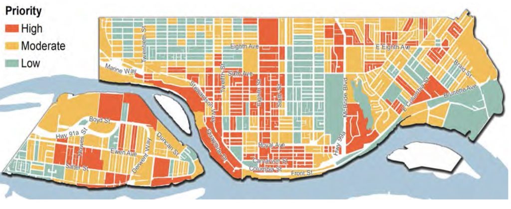
That plan is a great read, and I like how staff prioritized different parts of the City for faster planting. Recognizing that tree cover is inequitably distributed round the City, and that it would be better if we more evenly distributed that social, health, and economic benefits of tree canopy cover, staff used a GIS system to map out a few measures. Along with measuring areas with less trees, they also prioritize multi-family neighbourhoods to put more people near trees, neighbourhoods with more seniors, and areas more susceptible to Urban Heat Island effect. Overlaying those layers, and higher vs. low priority areas stand out:
It is also worth noting, this isn’t just about going out with a back hoe, digging a hole, and plopping a sapling in the hole. Trees need some significant support to prosper in urban areas, especially in the first few years. With asphalt and concrete everywhere, there is not enough healthy water-and-nutrient-providing soil around a tree in many areas, so a soil cell needs to be constructed to give the roots a chance to establish. Trees are sensitive to drought and frost and wind until they get established, so they need watering, they need pruning, and other care in the first few years. If we lose 10% of the new plantings every year, we are doing pretty well. They also need to be planted mindfully so they don’t tear up the sidewalk next to them, or mess up the sewer lines under them. And with climate change, we need to be cognizant of the species planted and the diseases and pets that are endemic. For our tree strategy to be successful, we needed staff dedicated to this work.
Fortunately, we are getting grants both large and small to help us with this work, and are committed though our Climate Action Strategy to continue to fund this work. It also helps that we have both staff and a Council who recognize that planting a tree today is an investment worth making so we have a better community 20 years down the road.
As for that block of Simpson Street between Columbia and Richmond: there is an identified paucity of street trees there, which means you will be getting those street trees sooner than some of the rest of Sapperton. It’s that red block in the picture above. Of course the overhead power lines are on the north side of the road. That means more diminutive trees on the north side but the south side should be able to host full-sized trees, and provide a lot of shade across the street. I’m assuming (but don’t know for sure) that there are no utility conflicts under the boulevard that would limit root fecundity. And it looks like the City is planning hop hornbeams and Chitalpas. So spring flowers to boot!
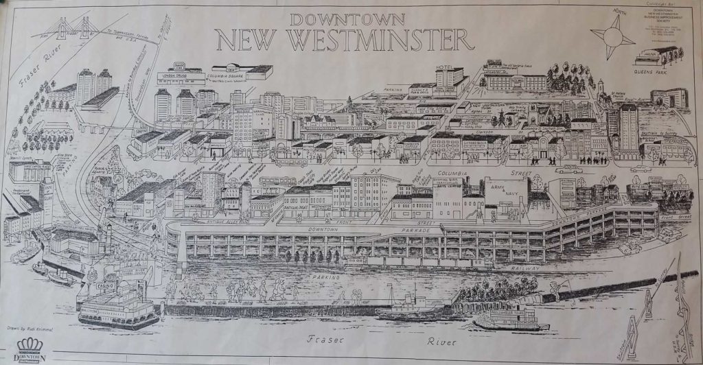
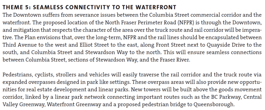
From researching the OCP and Downtown Community Plan it looks like Front Street generates a lot of noise pollution and significantly reduces the air quality for residents due to the freight trains and trucks that use it. There have been talks of eventually encapsulating the train tracks and Front Street and even the zoning bylaws or OCP states the buildings should be compatible with encapsulation. Toronto looks to be doing something similar and placing a park on top.
I realize that encapsulating tracks and Front Street will be very expensive and is likely decades away (Frankly I’m skeptical that it’ll happen in the next 25 years) Any idea what the City has in terms of timeline, vision and potential land use on top of the structure? If the idea is dead in the water/a pipe dream/no longer part of the City’s vision what are the City’s plans to address the safety, noise, and pollution in the downtown area?
Short answer is the idea is no longer part of the City’s vision for the waterfront.
Over many decades, there were various vague plans to build over the rail lines on the waterfront and/or Front Street. I’m not sure when this idea was first floated, but with the de-industrialization of the port and re-imagining of the entire downtown waterfront and Quayside starting in the 1980s, a lot of visions came and were either realized or went away when a new vision came along. Looking through old City planning documents from the last half of the Twentieth Century, you can see some of the encapsulation schemes that were sketched up. Some frankly fanciful.
It was never (to my knowledge) costed, and it was not clear who would pay the monumental cost. Its also not clear if the railways would agree to encapsulation or if the Ministry of Transportation would agree to a regional truck route that did not permit hazardous materials (because they are not allowed in tunnels). I don’t think anyone was concerned about what happened to the businesses and historic buildings that face Front Street. The vision seemed to rely on the entire waterfront, from the River Market to the Pattullo Bridge, being converted to residential towers, at least a dozen of them. These were pencil-sketch concepts, and I’m not sure there was ever a real understanding how to get there.
As recently as 2010, the conceptual idea was still bouncing around, as it worked its way into the Downtown Neighbourhood Plan – the planning document that serves as the Official Community Plan for the area below Royal Ave. When the new OCP was adopted in 2017, the Downtown Community Plan was included as an Appendix – as placeholder until a new Downtown Plan was developed. And it included this:
Since then, events have unfolded, and these became the proverbial best laid plans. I would suggest the one event that was more significant than any other was the demise of the North Fraser Perimeter Road (NFPR).
To understand the encapsulation idea, we need to understand the NFPR. There was a vision around the Turn of the Century (can you believe that phrase applies to 20 years ago!?) to shift more of the riverfront landscape of the Lower Mainland to “goods movement”. The so-called Gateway Program required the building of two limited-access high speed freeways, presumably to service trucks, but open to all traffic on either shore of the river. The South Fraser Perimeter Road was built, the NFPR was not. Primarily because of the horrifying impact on New Westminster.
The vision for the NFPR was 4 lanes, limited access, from a new expanded Brunette Interchange to the Queensborough Bridge connecting east and west to (not really clear). This may not sound so bad if the road is encapsulated from Elliot Street to Third Ave as suggested in the clip above (requiring, I note, the longest road tunnel in Canada), but what about east and west of there? There also existed the not-insignificant problem of pinch points like the historic Station building (Kelly O’Bryan’s) and interface with the SkyTrain guideway. Between the (federally regulated and not going anywhere) rail lines and other not-easy-to-move infrastructure, there simply wasn’t room for four lanes of traffic, buried or otherwise.
And there was the wider context of what it means to our community. If encapsulation addresses noise and fumes downtown, the NFPR only increases noise and fumes in Sapperton, in Fraserview, in the West End. And as more lanes always induce traffic, the knock-off traffic impacts on our surface roads would, if every other example in the history of building roads in cities has demonstrated anything, destroy the livability of many parts of the community within the noise-and-exhaust shed of the NFPR itself. Don’t get me talking about the Braess Paradox and Induced Demand.
The NFPR was a bad idea, and needed to be killed. It was killed in 2011 when TransLink proposed spending a couple of hundred million dollars on a key eastern connection to United Boulevard, and the community recognized it for the community-destroying freeway plan it was. I am really proud of the community who stood up to stop it, and the Council of the time (long before I was elected) that made it clear to senior governments that this was not on. We literally saved the City back in 2011, and TransLink went on to fund better things, like MOAR SKYTRAIN.
So without the NFPR, a different set of decisions had to be made. When it came time to invest in maintenance and upgrades to the Front Street Parkade, the lack of an NFPR meant we were able to right-size the structure by removing the older half of it, daylight some business fronts, and create a new public space. When the design for the Larco Parking Lot (now Pier West by Bosa) was being re-evaluated, we no longer wanted or needed an elevated podium cutting people off from the River, and were able to leverage another couple of acres of public park space for the Downtown. As we adopted whistle cessation downtown, as we design a new accessible pedestrian overpass to Pier Park, as we look at upgrades to the McInnis Overpass, as we plan greenway improvements along Stewardson, etc. etc., it is about planning for something that fits our community needs and connects our community better, not accommodating 4 lanes of high-speed truck traffic to slice our community in half, using an unbudgeted, difficult-to-realize, and half baked encapsulation idea to soften the blow.
The language in the Downtown Neighbourhood Plan has not been updated to reflect this change, but the planning we are doing around downtown certainly has. For the better.
I said I was going to spend some of the holidays clearing the Ask Pat Queue. Here we go with the first one from a drummer of some note:
Heflip asks—
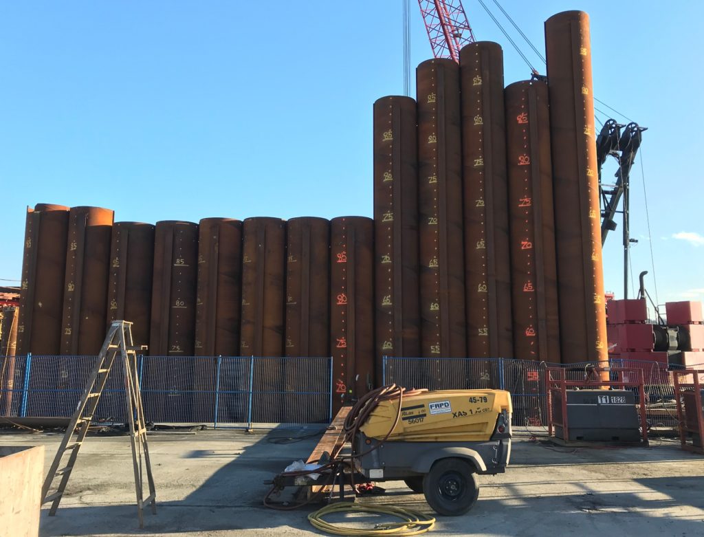
The development on front street along the river’s edge…the underground portion being well below water level…is this a smart idea? Some engineer somewhere thinks so I suppose. I guess we’ll find out if it sinks or not.
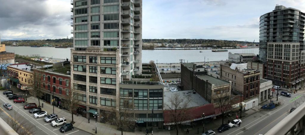
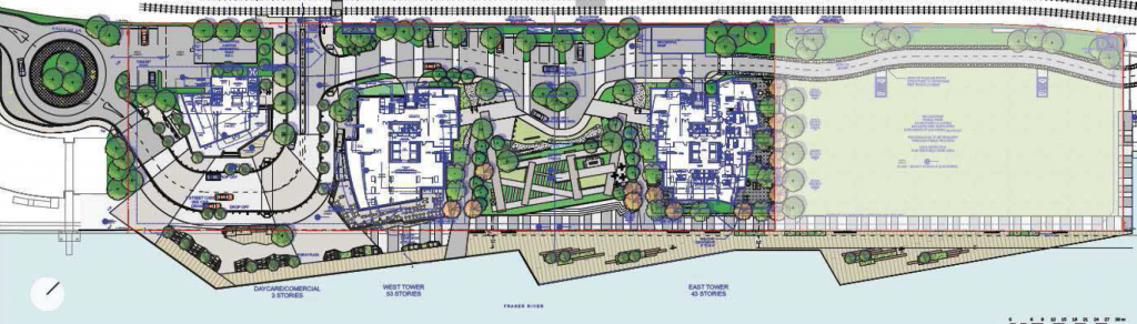
I assume you are talking about the Pier West project currently under construction at the foot of Begbie Street. Indeed, the history of the site, going from 5 towers to three to two, from over 1,000 units to under 700, from an elevated parking pedestal to below-grade parking, and the attendant public benefits is outlined in this previous blog post from around the time the current iteration was approved.
But you asked about engineering and water.
Yes, engineers think it is a fine idea, if a bit complicated and expensive. I am not an engineer, or even an engineering geologist, but I know just enough to recognize the engineering of this site probably looks more challenging than it is. The building is not built on soft riverside sediments, but is within them, and rests on a series of piles driven into well compacted glacial sediments and pre-glacial rocks (probably Huntington Formation?) that are not as far down here as people might think. Around the Lower Mainland and the world, there are many buildings on piles in much similar or more challenging conditions. Just in the photo above, there is the Alex Fraser Bridge, every tower on the New Westminster Quayside, and the dynamic loads of those container cranes at silos at the port. The engineering of doing this work is really, really well understood by people who do that work, and seismic standards for this type of construction are remarkable. The buildings will almost certainly not “sink” any more than any other building built in the 21st century in the Lower Mainland.
Secant piles that will keep the underground garage and the river from interacting. Those numbers are “feet to the bottom”. They go a long way down.
The portion that is below grade is the parking structure, both for the building occupants and public parking for the adjacent park and commercial areas. By pushing the parking below grade, we were able to negotiate more than 2 acres of public park and waterfront boardwalk space, which will be a huge shift in how the Pier Park operates. The City will finally have a realized riverfront plan.
Parking “below the river” is an interesting visual, but again, not as challenging as non-engineers may presume, and not that unusual. Many of the buildings in the Quayside on New West have parking garages that are below the top of the river, especially during flood stage. The Secant Pile wall you can see on the site is a well-established construction technique that is very well understood by generations of engineers by now. The location of this structure is perhaps dramatic, but most large buildings with significant underground garage structures are in a similar situation, in that the lower levels of the garage are below the groundwater table, and are surrounded by water-saturated soils that would love to flow into the garage. Some manage this by actively pumping away the groundwater. But more commonly now, they just build the garage as a “bathtub” that is effectively waterproof, with a few sumps and pumps to address any minor leakage or seepage.
The building is also built to the currently required flood level, including anticipated sea level rise effects related to climate change during the life cycle of the building. But that gets us talking about floods and sea level rise, and I have another Ask Pat in the queue about that, so stay tuned.
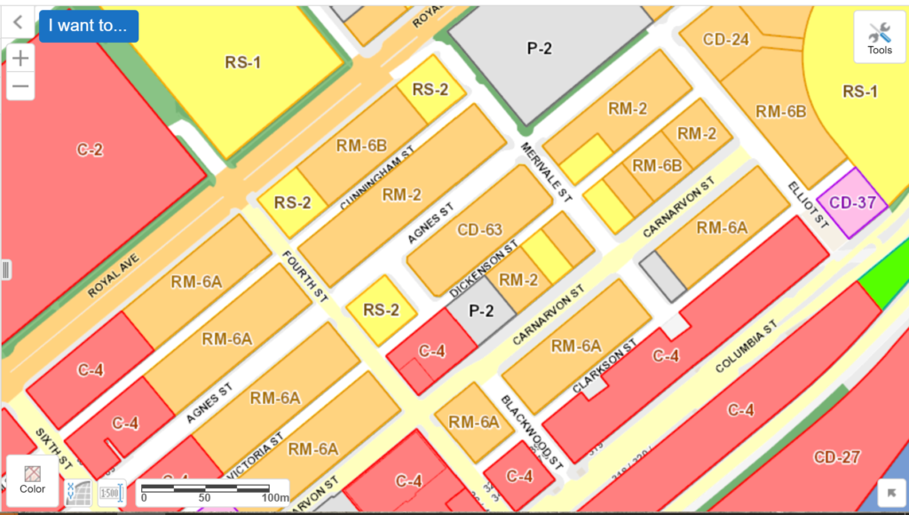
How do zoning and bylaws work in New West? It seems to me that allowing for small retail spaces in neighbourhoods like the ones surrounding Agnes and Carnarvon @ Elliot, for example, would be of great benefit to the community: More walking distance shops and such (I’m thinking coffeeshops, produce stands, maybe a convenience store) would make this area more walkable, livable and agreeable to its inhabitants. I have seen some small stores close to brow of the hill, and I know that there are stores on sixth, but why not more centric?
To answer your first question: it works like zoning everywhere else in BC (except Vancouver), because although the powers local government have under zoning are very broad, they are set out in Provincial legislation. And as in many other things, when it comes to zoning power, the Local Government Act giveth, but the Community Charter taketh away.
There is a lot of talk in urbanist and activist circles about zoning, some even suggesting that it is more trouble than it is worth. There is no doubt the history of zoning is problematic (racist and classist zoning was more the norm than the anomaly for North America for much of the twentieth century), and it is currently a cause of (or at least a functional part of) a lot of inequity in communities. However most don’t really understand what it is as a tool in modern local government.
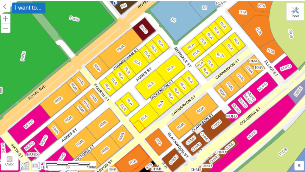
Many armchair planners have a perhaps SimCity-derived thought that zoning is designed to keep noisy, polluting, industries and busy, crowded commercial areas separate from comparatively pastoral and quiet residential areas, so people are healthy and can sleep at night. But in BC, that type of high level distribution of land use is more achieved by an Official Community Plan (OCP). Zoning is a finer-grained distribution of land uses within those bigger categories. It also speaks more to the size, shape, and form of development within neighborhoods, and it also manages more specific land uses and how different land uses are mixed together within the same area. A neighbourhood might be designated Residential in the OCP, but zoning may allow “four floors and a corner store” types of buildings, or even stand-alone buildings that don’t necessarily “fit” the strict OCP designation for the entire neighbourhood, like a stand-alone cafe in an otherwise residential neighbourhood.Map of the OCP designations for the eastern part of Downtown from the City’s on-line map.
It’s important to note that zoning doesn’t necessarily drive changes in use, it is usually the other way around. If a specific use is allowed in a zone, it doesn’t necessarily mean anyone will actually come along and do that use, or build a new building for that use. Council rarely re-zones or changes the allowable uses on a zoned piece of land unless a landowner requests it by making a rezoning application – they want to change the use and ask the City for permission.
Map of zoning designations in the eastern part of Downtown from the City’s on-line map.
The thing about zoning is that zoning changes for any lot need to be approved by Council, and (this is the big part) Council can say “no” to a change for pretty much any reason they want. Most powers of Councils are limited by legislation or common law, and we are expected to act reasonably. In administering building permits (as a random example), we cannot capriciously withhold a permit if you want to build something – as long as what you are building meets the zoning and the building code, no bylaws are violated, and you pay your fees. We can’t just say “no” without providing a reasoning for why, and can get dragged into court if we act arbitrarily in refusing you a permit for, say, a bathroom renovation. But if you ask us to change your zoning, we have almost unlimited power to say “no” and you are unlikely to have any recourse.
As a result, a City can ask for pretty much anything in exchange for zoning – Development Cost Charges to pay for sewer, water, and transportation upgrades, so-called “Voluntary” Amenity Charges to pay for other things in the City, we sometimes ask for a strip of land to be dedicated to the City for a boulevard, or sidewalk replacement or other upgrades to adjacent City lands. We can ask the developer looking to re-zone that they build space in their proposed building for Daycare use or Affordable Housing or that they build more (or less) parking, or that they paint their building a different shade of blue. Every rezoning is a negotiation.
Now, this of course is a power a wise Council will not want to abuse. Besides making ourselves unpopular and getting voted out, making rezoning too onerous will cause landowners to scoff at the demands, and no-one will invest in developing your City, which might mean you will not achieve the goals of your OCP. On top of this, the community may lose out on those amenity benefits that could be negotiated. Of course, a Council could cynically use this piling on of demands as a great way to prevent new housing from being built while not appearing like you are opposed to new housing. “This development just didn’t quite do enough to address (pick a concern)” is a great stall tactic that effectively shuts down development as easily as saying no, with predictable results. But as a practicality, most Councils want to make sure the community gets “its share” of the value that the developer receives when a property is rezoned. It’s a balance, and no-one does it perfect.
The point is, if we abolished zoning, we would need to replace it with another tool that provided the community an ability to leverage a fair share of the land lift (the increase in property value that comes with zoning changes in a land-constrained region such as ours) in order to pay for the externalized cost if development and community growth. Right now, it is the best tool we have for that because it is the only tool that gives Local Government negotiating power.
But you were asking about zoning for small retail. This has been a topic of *much* discussion over my 7 years on Council, going back to the last big OCP update. Part of livable, walkable, dense urban communities like Downtown New West is being able to walk to some basic services. I feel fortunate that I live in a part of the Brow of the Hill where I am a <10 minute walk from most services, and as such can do most of my shopping by waking or riding my bike. But there are areas of New West with a paucity of services within such a short distance, like the west part of the West End, parts of Upper Sapperton, or Port Royal in Queensborough. There are also some areas like the east aside of Downtown (as you note) are surprisingly far from some services, and probably don’t achieve the walkscore we would like to see for such a dense community.
Expanding on your example of the east part of Downtown, most of that area (other than Columbia Street, which is commercial) is zoned for low-rise multi-family residential, with a note in the zoning that higher density may be permitted if enough amenity is provided. Any retail coming to this area would need a rezoning. Would Council approve such a rezoning? I don’t know, but I doubt we are going to be asked to any time soon.
There is an ongoing discussion locally and regionally about retail space. I have heard owners of commercial property argue there is too much, and if Cities require retail space as part of new mixed-use developments, they will remain empty, especially as the traditional retail environment has been Amazoned into a state of… shall we call it uncertainty? Others suggest high lease rates and somewhat onerous triple-net lease terms are a result of there being too few spaces available and commercial owners holding all the cards. There is also a universe where both of these are true at the same time, and location and neighbourhood characteristics determine where your street or block fall on that spectrum.
Developers definitely would rather build residential, given the option, because they know the demand is there. Build residential, and it will sell for a pretty easily predicted price per square foot. Commercial space is not as certain. Building a residential property is also more predictable in how you fit it out. Every home needs a toilet and sink in every bathroom, countertops and appliances, wired and plumbed for in suite laundry and known kitchen appliances. But a commercial space is largely unknown. To use your examples, a coffee shop, a produce stand, a convenience store all need very different layouts, plumbing, electrical loads, even locations of doors. So commercial space built on speculation is built as an empty shell, creating uncertain costs for anyone who hopes to lease them and fit them out. I can point you to several places in the city where retail-at grade is still an empty shell years after the residential building it sits on is occupied.
So when the City talked about updating the OCP for the middle part of Sixth Street (between Royal and 4th), the question was raised about whether requiring retail at grade was worthwhile. Perhaps having more residential spaces built will provide better support to the existing retail spaces on Sixth, and zoning for retail grade is making it uneconomic to develop. The same conversation ensued along the Twelfth Street retail strip. Is more retail space needed? If we force developers to build retail at grade, will it be occupied? More importantly, will it make it so hard for a developer to make any money developing the area that nothing gets built, and then the existing retailers don’t have nearby customers. The answer is not simple, and opinions vary.
Where we do see new community-serving retail is in major development projects. Plaza 88 is an obvious example. I think if we were planning Victoria Hill now (instead of 15-20 years ago when the vision for the community was being hammered out), we would include more commercial spaces, and perhaps a few larger retail spaces, though no-one is going to open a major grocery there (with a Safeway and a Save-on each just a little over a km away). That said, the few spaces that are there have taken a significant amount of time finding their purpose. Was that because there are more spaces than needed, or because there are two few to create a real “hub”? The long-proposed “Eastern Node” development area in Queensborough would finally bring some community-serving retail to Port Royal, which is now an established medium-density residential neighbourhood with nary a place to buy an apple. In hindsight, the long wait for this commercial node is really disappointing for the City, and for the residents of that neighbourhood. Hopefully these lessons are being learned and Sapperton Green looks to not only bring more commercial square footage, but is phased to bring it earlier in the neighbourhood development.
So, back again to eastern downtown. To my knowledge, there is only one development in the works in that neighbourhood, and it came to Council as a preliminary application as a mixed use residential, affordable housing and childcare – but no commercial space. For a new commercial space to be built in that neighbourhood, someone would have to come to the City with a plan, and go through a rezoning to make it happen. I cannot predict if Council would support this plan or not, but for the reasons I outlined above, that is just not where the market is for development now, or really where the market is for retail. Neighbourhood convenience stores you do see around mostly have one thing in common – they have been there for a long time and are very low-cost operations. Starting a new one would probably be a financial risk with little chance of recovery. I suspect if you could make money doing it, people would be doing it. So, alas, I wouldn’t hold my breath for any new commercial or retail being built in that area (other than along Columbia) any time soon.
Last month I put forward a motion (passed unanimously by Council) asking that we commit to planning and building a AAA Active Transportation Network in New West. I thought I would take a bit of time to outline what that means (from my point of view, anyway, because I am always cautious not to speak on behalf of all of Council) and talk about why I think it is important for us to do it now.
As I am often using terms more familiar to transportation advocates than your average person, maybe I could start by talking about the italicized-in-blue term I just used. Because this is not just about bike lanes. Though it may include bike lanes.
“AAA” stands for All Ages and Abilities, to differentiate it from infrastructure built specifically for me – the “avid cyclist” stereotype. I’m a healthy middle-class middle-aged sorta-fit guy who has been riding bikes pretty consistently for more than 45 years. I have raced bicycles (mostly mountain bikes; remarkably unsuccessfully), I have commuted by bicycle in big cities and small towns, ridden next to highway traffic over mountain passes sometimes more than 100km in a day. I even spent some time as a bicycle courier in downtown Vancouver, back when that was something people did. Because of this history, I have a high tolerance for danger and an inflated sense of invincibility. I don’t need bicycle lanes or special infrastructure to get me riding my bike. I’ll ride anyway (and probably irritate a few drivers on the way, but we’ll get back to that). AAA bike infrastructure isn’t for me.
Transportation advocacy used to be about people like me – wanting to make trips safer for a American Wheelmen (yes, that was the name of an early cycling advocacy group, and by early, I mean until the 1990s). But there has been a shift in North America since then, following after a couple of decades of progress in Western Europe, to shift towards making cycling infrastructure work for more people. Ideally, everyone who chooses or might choose to ride a bike (or trike, or quadcycle, or handcycle, etc.), but may not be avid about it. Like the way many people drive cars or ride buses, but aren’t avid drivers or avid passengers.
There is also advocacy around “880 Cities”, the idea that if you build a City that is safe enough to make an 8 year old and/or an 80 year old comfortable and independent in public spaces, it is making the space safe and accessible for everyone. You can read into that that people should be able to ride their bikes to school, even in elementary school (like I did as an 8-year-old). An 80-year-old should be able to ride as safely as they can walk, to expand their reach and options in a community and make them less reliant on cars (like my Mom does, with the help of her E-bike). To build for these users, we need to build AAA.
This corresponds with talking about Active Transportation Routes instead of the more restrictive “bike lane”. This means infrastructure should accommodate adult trikes or recumbents for people who may rely on the extra stability they offer. It should also be comfortable to share with people who rely on scooters, electric wheelchairs, or similar lightweight controlled-speed rolling devices. Multi Use Paths (MUPs), where pedestrians are mixed with rolling users should be built in a way that accommodates both user groups and their distinctive needs. Moving bicycles off of busy roads and onto sidewalk-style MUPs makes the bicycle riders feel safer from the larger, faster vehicles, but it may do so by making bicycles the larger, faster vehicles making some pedestrians feel less safe, unless a MUP is built what that in mind.
Finally, we need a network. Bike lanes are like roads, sidewalks, and pipes: they don’t do as much good until they are connected to something. Some people note they don’t see a lot of people using the Agnes Street bike lanes, or the bike lanes in front of the new high school, but both of them represent an important first piece of infrastructure that isn’t yet connected to a network. For users like me, it’s great to have those sections of increased safety; for less confident users, 100m of missing safety between two great bike lanes can be the barrier stopping them from riding on either. This is the issue being addressed by current region-wide “Ungap the Map” campaigns.
So, where is New West now? We are six years into the current Master Transportation Plan, and have made serious progress in pedestrian safety and accessibility. Though it lags behind a bit, we are starting to see some key parts of our planned cycling network come into place. However, the planned bike network envisioned in the MTP is no longer, I would argue, the vision for a AAA Active Transportation Network we would choose to develop if we were starting today. We can, and should, do better.
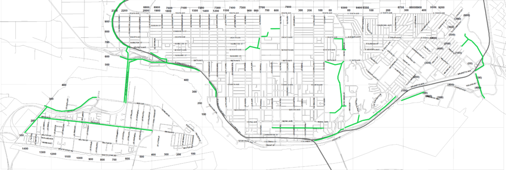
By way of sketching on the back of an envelope, our current network of infrastructure that meets AAA standards looks something like this:This is a map I sketched up using MSPaint just for discussion purposes. This is NOT an official City of New Westminster map, and possibly not even accurate.
There is some good stuff there, but it is disconnected and incomplete. Of the AAA we have, it leans heavily on the MUP-in-the-Park bikes-are-for-recreation model of the 1990s.
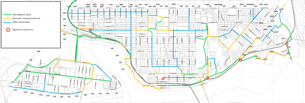
In my mind, a complete AAA network built off of our existing system would look something like this:
Once again, not a map created or endorsed by the City of New Westminster or anyone else. I just sketched this up to facilitate a discussion. Actual plans will probably look different than this.
Note that there are two kinds of future AAA Active Transportation routes shown in my sketch. Those shown in Yellow would comprise separated and protected bike lanes and/or MUPs (like the Agnes Greenway or the CVG past Victoria Hill), where people rolling or riding are not expected to share space with cars. The other type is shown in blue, where bikes might continue to share road space with cars but only if there are specific structures to significantly calm the traffic and force cars on that route to move at bicycle speed. No cars passing bikes, no person on a bike placed between a moving car and a parked car, and intersections designed to be safe by people using all modes. There are several routes like this in Vancouver (I think sections of the Ontario Street or 10th Ave bikeways in Mount Pleasant qualify), and maybe London Street through the West End is the closest example in New West (though there could be some improved calming and signage there). There is some work for us to do to establish the standards we want to apply to safety/comfort of these routes to call them AAA, including the level of traffic calming we can achieve vs. the need to separate.
Finally, I want to emphasize that the time is now to do this work, for a variety of reasons.
One result of the pandemic is that it resulted in a generational shift in how people around North America move about their cities. Bicycle take up has happened at an unprecedented rate, such that stores across North America ran out of bikes and parts to maintain them. Add to this the battery and technology revolutions that have brought reliable e-assist bikes and other personal mobility devices that open up active transportation to many people who did not see that as a viable option previously.
Some communities have seen more rapid pick-up in this shift than others. And surprisingly (unless you have ever been the Madison Wisconsin or Boulder, Colorado), it is not warmer climate or flatter topography that correlates with this take-up, it is the availability of safe infrastructure. Like roads – build it and they will come.
Examples abound, but I’ll limit myself to two: In Paris, Mayor Hidalgo introduced Plan Velo, and committed to 1,000km of cycle paths, a key part of the 15-minute City vision, transforming her city into one that is now seeing close to a million bike trips a day. Recently, emboldened by a landslide re-election, she doubled down with another $300M investment in expanding bike lanes. The City of Lights is becoming a City of bikes.
Closer to home, the work Victoria has done since adopting a 5-year plan for a AAA bike network in 2016 has been equally transformative. With most of the network now installed, it is seeing incredible take-up, and Victoria has established itself in a few short years as one of the most bike-friendly cities in Canada.
At the same time, senior governments in Victoria and Ottawa are funding Active Transportation projects as never before, so we don’t have to pay for this alone. But right here in New West, we have introduced an ambitious climate action plan, framed around 7 Bold Steps. These goals will not be achieved unless we start shifting how we move around, and how we allocate road space in the City, and only a complete AAA Active Transportation network will get us there. The time is now to commit to this work, and to ask staff to give us the data we need to integrate that commitment in to our 5 year capital plans.
I put forward a motion last Council Meeting regarding revitalization of Downtown, and I thought I would write a bit of a follow up about my thinking in working with Councillor Trentadue on this motion. The motion was seconded by Councillor Trentadue, and supported by all of Council, but it is always important for me to remind folks that what I write here on my blog reflects only my thoughts, not necessarily those of my colleagues on Council. Though my ideas on this have been informed by some really enlightening discussions with business owners downtown and members of the BIA.
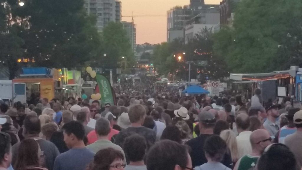
It has obviously been a difficult last year and a half for many in our community. This in no way makes us unique in the Province or in Canada, but I want to recognize that the results of the Pandemic hit the historic Downtown of New Westminster at a time when there is already a lot going on, both good and bad. Perhaps that requires a bit of a step-back to look at Downtown New West as a Regional City Centre, and what makes it unique.
The City of New West has committed to the Regional Growth Strategy shares with the other 20 Municipalities that make up Metro Vancouver; a plan aligned with the TransLink Regional Transportation Strategy. A keystone to both of these plans is the increase in new density in identified Regional City Centres – with Downtown New Westminster being one of those identified centres. The vision for these centres is higher density mixed use (commercial, office, retail and residential) at high-service transit nodes to reduce reliance on cars. As a result of this plan and our exceptional Transit-centric location, Downtown New West is becoming one of the densest and most rapidly-growing residential neighbourhoods of the region. Being one of the few such centers with a strong historical walkable street scale, it is also one of the regions of the Lower Mainland most reliant on Transit, and least reliant on cars as a primary transportation mode.
Indeed, since the Downtown Community Plan was developed, we have seen significant residential growth, especially in the last few years, with some key developments coming on line. With more recent emphasis on Family Friendly suites, Purpose Built Rental, and Affordable Housing, there is a much richer and dynamic residential mix in the community as ever. This is even extending to there being more young families buying in the older and (slightly) more affordable units in Quayside. In short, population is booming Downtown, which should be good for local-serving retailers.
At the same time, we have had some significant setbacks. The loss of a portion of the Pier Park was probably the highest profile, and definitely reduced the public space amenity for Downtown residents, but the more recent loss of the building that housed 4 businesses on Church and Columbia was a real punch in the gut. This came after we lost an anchor retailer as the Army & Navy closed their last 5 locations. At the same time, the great work the BIA has done over the last decade to activate the street and draw people into Downtown through events and directed promotion has been hamstrung by Pandemic restrictions. And, though I am optimistic about the medium-term benefits of some of the larger developments currently under construction in the downtown, the ongoing impact of construction noise and disruption is further eroding livability at a time when these impacts pile up. And then there is the damn sewer work.
I would argue that the role of Downtown New West are a Regional City Centre makes it fundamentally different than our other (still important and valued!) commercial strips like historic Sapperton, Uptown, Ewen Ave or 12th Street. I would also argue that Downtown is facing a different set of challenges than the City’s other commercial areas, and needs a different and more proactive approach. And it needs it soon.
There are some interesting contrasts in Downtown. There is actually not an abundance of leasable retail space available right now for a new business to set up in. Indeed, there are a few businesses doing really well downtown, and at times the streetscape is really inviting. There is, perhaps surprisingly, a fair amount of office space in all three class levels yet office vacancy is under 5%, which is one of the lowest office vacancy rates in the Lower Mainland. At the same time, there are vacant storefronts in buildings that have been verging on decrepit for a long period of time, creating significant “gaps” in the retail environment. Finally there are sites like the Copps store site (still a hole 8 years after that devastating fire) and the Kyoto block empty lot right across from the Anvil Centre (empty 7 years after Council last saw a development proposal) that seem to need motivation to get activated.
The motion here is not to put pressure on existing business operators in the downtown – they are doing their best in tough times. Nor does the City have real power add specific retail businesses residents might like (be that a hardware store or a haberdashery). What we are asking is for staff to suggest tactics the City can apply to get these underperforming lots and derelict buildings activated. Though I (of course) have ideas, we really need Staff guidance to let us know what the suite of regulatory tools we have, as the relationship between a Municipality and any business is strictly defined in the Local Government Act and the Community Charter. We appear to have some special powers under the New Westminster Redevelopment Act that we have not yet exercised, and I would love to understand that fuller.
We also may need to have a conversation about street-level retail/commercial space having an amenity value we can apply in new development proposals. I would also love to see us evaluate radical parking relaxations for new buildings on Columbia, in light of the Transit-Oriented Development goals of the neighbourhood. The prohibitive cost and significant risk related to digging deep holes for parkades may be a barrier to innovative builders interested in making something cool happen on Columbia, and the value represented by that parking may be better applied at assuring buildings support other goals in the historic downtown.
These are my opening thoughts, I really hope in further conversation with the business owners, our City’s great Economic Development staff, and the wider community, we can bring some confidence back that Downtown New West will be a walkable, livable, full service community that supports its growing population.

 M
M