I wasn’t going to comment on this topic, but when someone makes a series of terrible arguments on the radio in the morning before I’ve had my coffee (one so bad that even Rick Cluff noticed its flaws – “Rick Cluff noticed” not being a phrase I ever thought I would type), I get all riled up, stew about it for several hours, and now I get to vent.
There are people in BC right now who think that speed limits need to be raised. The only shocking part of this is that they apparently have the ear of the Government, and in typical Premier McSparkles® campaign-when-asked-to-lead style, a public conversation is being stoked on the issue.
No, wait. That’s unfair. With the benefit of doubt, the Government is asking the public what they think about an idea instead of making a rash change, which is what they should be doing. This is actually useful public consultation, and they should be acknowledged for this. So let me tell them what I think.
I think the first question the Government, and everyone else, needs to ask is: What problem are we trying to solve?
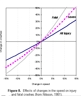
Safety? “Speed doesn’t kill, sudden deceleration does”. That’s a funny joke, but sudden deceleration from higher speed kills much more effectively than sudden deceleration from low speeds. There is extensive research on this, but perhaps the best study is a comprehensive review by Stuster and Coffman (1998). They looked at numerous studies from various jurisdictions that looked at the effect of increased and decreased speed limits on crash statistics and crash severity. The vast majority of studies correlated increased speed limits with increased crashes, increased injuries, and increased deaths. Even the few studies that did not show an increase in accident rate showed no decrease. There were enough instances reviewed they were able to create a statistically significant rate of impact calculation: Rate of crashes causing injury increase 3% for every 1 km/h speed increase. Increase average speed limit by 10km/h, (say, 100km/h to 110km/h) you will have a 30% increase in people injured in crashes. The % increase in fatal crashes is even higher. He science is clear – increasing speed limits kills and injures people.
Cost? Are we somehow saving money by driving faster? Maybe there is a “productivity cost” argument to be made for people who commute to Merritt and can save 10% of their travel time, but I haven’t seen anyone trying to make a business case. Considering gas mileage and wear and tear on a car increases with speed (at first principles, the power required to move a car through the air increases with the cube of the speed – to go twice as fast, you need to apply 8 times the power), the costs and lost productivity attached to increased injury and death, and the cost related to required road upgrades to maintain “safety factors” (see below), I an skeptical that business case could ever be made.
Efficiency? We aren’t increasing road efficiency or “fixing” traffic congestion (one is unlikely to avail oneself of the maximum speed limit on a road suffering from any kind of congestion), nor are we increasing your gas mileage (see that stuff up there about needing 8 times the energy to go twice as fast), so increased speed limits aren’t an efficiency issue. Actually, the Province has committed to taking action to reduce greenhouse gas emissions from the Transportation sector – raising speed limits is counter to this stated policy goal.
Enforcement? It seems people are irritated getting speeding tickets. I’m also sure people are irritated getting drinking & driving suspensions, and I am positive that taking their exotic cars away irritated the hell out of these guys. However, when a law exists for a clear public protection reason, and there is good science behind that policy, I don’t see “irritation” as a good reason to get rid of the law.
This morning I heard arguments on the CBC Early Edition by Ian Tootill, the leader of a group with the appropriate misnomer “Sense BC”, who are leading the public relations charge here (the interview can be heard at this link, January 9th edition, starting at about 1:21:30). He threw a lot of ideas out there, but to answer the first question (what problem are we trying to solve?), he said something to the effect of (and I paraphrase): “We don’t want to make scofflaws out of the motorists out there who now speed because the roads are too good/safe for the related speed limit”.
This argument contains within it various wrong ideas.
1: Mr., Tootill will not declare what speed limit he would like to see (he mentioned 130km/h or more a year ago, but is now more coy about it), but suggests we should use an Institute of Traffic Engineers equation, which is to use the 85th percentile. That means measure the speed people are using, and set the speed limit such that 85% of the people are going at or slower than the limit. This, of course, makes 15% of people automatically “scofflaws”. This issue is also at odds with his statement of “if you set the speed limit correctly, you don’t get non-compliance”. Even ideally, you get 15% non-compliance.
2: This argument relies on an idea (one Mr. Tootill repeats in the interview) that drivers are the best judges of what a “safe speed” is. The problem here is obvious – people, almost all of them, routinely exaggerate their own driving skills. The vast majority think they are really good drivers. Evidence on the road proves otherwise. Do I want the Lamborghini kids from Richmond, the woman applying eye makeup at an intersection after making an illegal lane change, or the 40+% who admit to texting while driving determining what safe driving habits are for me, and for each other?
3: This problem is exacerbated by another wrong assumption. Mr Tootill seems to think that speed limits are unnecessary because if people drive faster, they will somehow drive better. This is what he means about “changing the culture” and forcing people to “drive with purpose”. Seeing as he is outspoken against increased enforcement, I’m not sure how he plans to “raise the bar of expectations” or force better “lane discipline”, and why those compare favourably to enforcing speed limits.
4: The biggest failure, however, is the argument that we build these big, wide, safe roads (the new Sea to Sky highway was used as an example) but we don’t increase the speed limits. This shows a complete misunderstanding on Mr. Tootill’s part about how road engineers build roads.
An Engineer’s first job is always to protect public safety. One way they do this is to introduce “safety factors” into things they design. You ask and engineer to build a bridge that can support a 10T truck, she will build one that can support a 12T or 15T truck in ideal conditions. This is because they know that there might be minute flaws in the steel, some bolts might be cross-threaded during construction, a ton of snow might fall on the bridge deck, or any of a myriad of small things under the category of Shit Happens might add up such that if you drive a 9.9T truck over a bridge actually built to support only 10T, it might crack.
Engineers know that people, information, and equipment may be fallible, and one way to address this is to build in this “safety factor” between ideal conditions (the ideal capacity of the bridge) and the real world (what you post as the capacity of the bridge). As an aside, the remarkable Richard Feynman’s contributions to the Rogers Commission Report on the Space Shuttle Challenger accident are a fascinating study in what happens when “safety factors” are misunderstood and misapplied).
So how do you apply such a “safety factor” to engineering a road with a 50km/h speed limit? You build the curvature, the lane width, and sightlines adequate for, say, 80km/h driving. Does that man everyone should drive 80km/h on it, because if “feels safe” at that speed?
I had a discussion related to this with a traffic consultant during the consultations for crosswalk improvements on East 8th Ave. When a few of us suggested better protection for pedestrians and even a pedestrian-operated crossing light, he countered that the traffic and speed on the road did not warrant this. I asked if he meant the posted speed, or the actual speed on East 8th. It must have occurred to him (I politely suggested) that people driving on a 12m-wide two-lane with few trees and 1.5km between traffic signals in the middle of an otherwise congested urban area might not travel strictly at the speed limit. In reality, the average speed on East 8th around Sherbrooke is closer to 70-80km/h. The “safety factor” is definitely misused to the hilt here.
So what happens if everyone starts driving within the “safety factor” designed into our roads? That “safety factor” goes away, like frozen O-rings on an SRB. The roads look like they are designed for faster speeds than posted specifically because they are not. They are made that way because shit happens, and when shit happens, safety requires wiggle room. This single reality of how roads are engineered makes the rest of Mr. Tootill’s argument bunk.
Mr. Tootill actually gives it away at the end of the interview (around 1:29:20) about where he mentions he recently went on a long road trip through the USA and brags about driving “considerably above the posted speed limits” most of the time and only getting caught once. It’s clear from this what Mr. Tootill’s interest is – driving really fast on public roads, and damn the consequences (as long as the consequence isn’t a traffic ticket)! Like the idiots racing exotic cars through the Massey Tunnel last year, or the street-racing moron who kills innocent pedestrians when he “finds the limit” of his car or his ability on top of a bus stop, Mr. Tootil is just a speed junkie who couldn’t care less about the risk he causes other people. Of course, unlike those examples, Mr. Tootill is a really good driver.
How about this proposal: We keep the speed limits where they are because of public safety, cost, and environmental benefits, and Mr. Tootill starts acting like and adult and gets his speed jollies at the track, not on our public roads.