Pattullo and the City

Having attended both New Westminster workshops on the Pattullo Bridge Replacement being held by TransLink, and being on the Master Transportation Planning (MTP) committee for the City, I noticed there is a o lot of misunderstanding about what the City’s position is on the TransLink process, and how the City’s MTP process fits into that.

Big caveat here: I am but one member of the Master Transportation Planning committee, representing the Advisory Committee on Transit, Bicycles and Pedestrians. The MTP committee has 20+ members from various City committees and outside agencies, and is only one part of the entire MTP process, being run by City Staff and outside consultants, under direction from Council. Therefore, nothing I say here is in any way the official position of the MTP committee, City staff or Council, or anyone else other than me. It is, however, based on what I have heard said at various official meetings and unofficial conversations with staff and council.

At the TransLink meeting at the Quay on Thursday, I talked to School Board members and several other people in the community who are usually very much in the know, and I found myself trying to explain what the relationship between the MTP and the Pattullo Bridge consultation is. Unfortunately, it has been cast a bit in the media that New West is once again being obstructionist, engaging in Nimbyism, refusing to take part, and being generally petulant spoilt brats. This despite the attempts by City Council and TransLink to broadcast that this is not the case.

So I am going to presume to interpret how the City sees this process happening, based on conversations at the (public and open) MTP meeting and with City Staff and Council members (so interpretation ahead: Staff or Councillors please correct me if I am off the mark here!)
I don’t see New Westminster missing the boat at all here, but I see the City taking a pragmatic, responsible and measured approach.

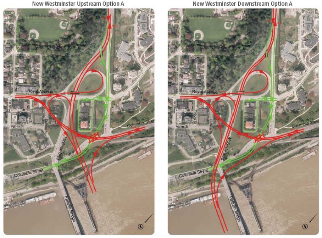
The first thing you need to keep in mind is that this round of consultations on the Pattullo is the first round of a very long process. TransLink will be taking the results of this consultation (preliminary design characteristics) and then entering an “operation analysis” phase. The preferred design out of this process will be tested at both ends for everything from how it manages traffic flows, how it fits the existing traffic patterns, how bikes and pedestrians will be accommodated, etc., etc. TransLink will also start the (potentially lengthy) joint Provincial and Federal Environmental Assessment process. Both of these steps will include significant public consultation and discussion. Then they will have to deal with the financing model, hiring a concessionaire, negotiating land swaps, etc. Even after this initial consultation, TransLink is at least 4 years from any shovels getting into any ground, and at least 3 before we know whose shovels it will be, and where they want to put them.  In other words: there is no rush to provide all the answers right now.

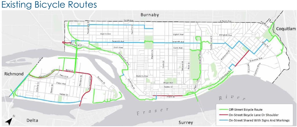
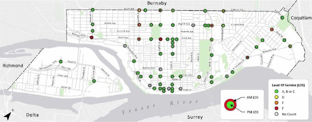
As for the City, they are updating their Master Transportation Plan, last completed 13 years ago. The MTP process will take about another 12 months. If you look at this diagram, it shows the steps for the MTP:

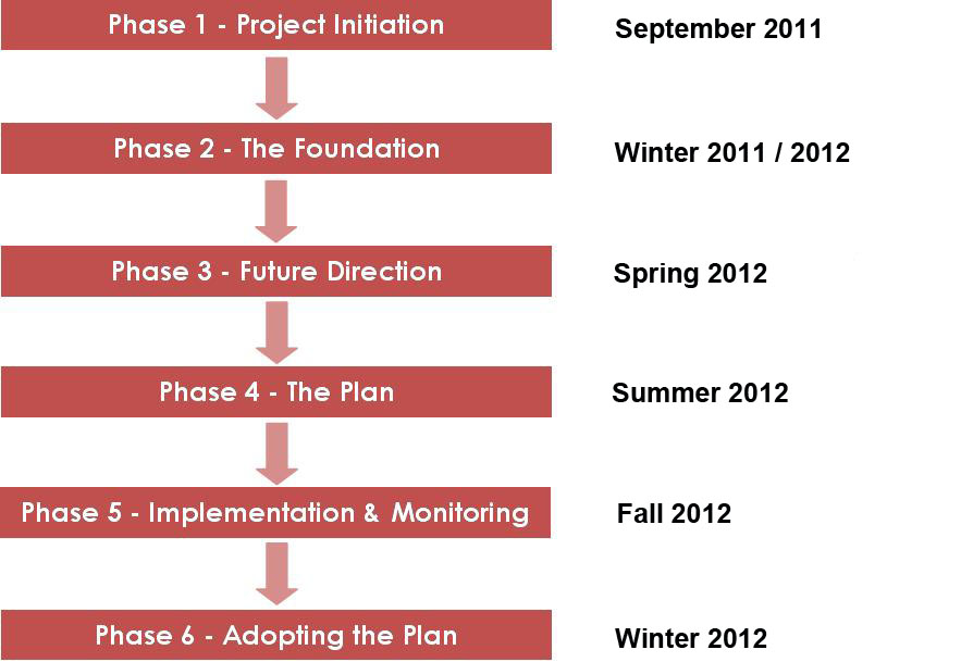
The City is currently completing Phase 2 (information gathering) and is about to embark on Phase 3. That is the phase where the City looks at where it is today, transportation infrastructure-wise, and determines what the Goals, Values, Objectives are for the coming decade or two. It is the big “visioning stage”. In a couple of months, after some public and stakeholder meetings, and likely workshops, the City will come up with a set of Values and Goals that define what type of transportation infrastructure the community wants to see in the foreseeable future (and in this case, by “the community”, I mean the residents, the businesses, the staff and the elected officials; everyone involved in the MTP process).

Then, when those Values and Goals are determined and formalized, the City will be in a position to approach TransLink and say: “Here you go. Make your plans address this”.

I don’t think there is yet a concrete idea of how that discussion will take place: will there be public consultations? Will the City report out to TransLink or do a joint consultation and reporting? No idea., but the point is that the City will take a bit of time right now to get a better understanding of that the community of New Westminster wants in a transportation system, then they will be armed with that knowledge when they go into negotiations with TransLink on how the bridge they want to build fits those parameters – or if it can even be made to fit them.

In the meantime, TransLink will be continuing to work on their process, but New Westminster will not be missing any boats here. We will be through that Phase 3 work in only a few months, TransLink will not likely have any operational plans in place for a year. When the MTP is at a point where useful data is available for TransLink, TransLink will be in about the same position as they are now. More importantly, TransLink knows and understands that this is the route the City wants to take, and seems to respect that decision.

So, if you really want to influence the Pattullo Bridge design? My advice is to get involved in the Master Transportation Plan process. Come to the meetings, attend the workshops, follow on-line, and provide your input at every opportunity.

Pattullo Bridge Consultation – Day 1

First off, you think TransLink would learn their lesson.

During their last foray to New Westminster to consult on highway expansion, the turnout was at first completely overwhelming, then Standing Room Only in the subsequent hastily-assembled  4- or 5-step consultation proccess. This month’s public open houses for the City’s Master Transportation Plan had a higher turnout than the consultants have ever seen at a similar event, more than 100 people each for the first phases of what, for most sities, is a dull planning document. The Lesson? Have a public meeting about Transportation issues in New Westminster, and people are going to show up! There is no excuse for having too small a room and not enough chairs for the participants.

I’m not going to talk too much about what Translink discussed at the Workshop at Centennial Centre on Tuesday. Daniel at City Caucus sums up the spirit of the room pretty well, and we were not really offered any info that isn’t available on the TransLink website for the consultation.

Instead I am going to talk about what wasn’t discussed at the meeting, and why that is a problem.

The first topic that was not up for discussion was the number of lanes. TransLink has determined they will build a 6-lane bridge with two of the lanes (apparently) dedicated to trucks only. No business case is made for this (for perspective, a transportation expert once opined to the NWEP Transportation Group that the difference between a 4-lane and 6-lane bridge could be as much as $300 Million). When pressed on the question of lane count, TransLink suggested 6 lanes was the only option on the table for “safety reasons”. The somewhat convoluted justification being that keeping trucks on the outside lanes keeps them from needing to change lanes on the bridge, or mix with the cars on the inside lanes, increasing safety for all users. That sounds good, unless you are paying attention. Take a look:

click to embigginate

All of the designs deal with on ramps the same way, but I’ll use this one as an example, because it is first alphabetically.

Say you are Dave the Truckdriver entering New Westminster from Surrey, over there in the rightmost lane. If you want to go east to Highway 1, you take the first offramp, if you want to go towards the Queensborough, you take the second offramp, if you want to continue north towards Burnaby, you stay on the main route to McBride. All are options, as all are on the Major Road Network and designated as Truck Routes. It is unclear where the main route changes from three to two lanes, but it is presumably at the first or the second offramp. If it is the first, then you will need to change lanes before then (unless that is your destination). If it is at the second, you will still need to change lanes before that. Trucks going North will always need to change lanes. So lane changing is inevitable unless all trucks are forced to a single offramp going in one direction, but that would significantly reduce the usefulness of the bridge for “Goods Movement”, wouldn’t it.

The same situation happens for trucks heading south down McBride onto the bridge, or entering the on-ramps from the other roads, they are either going to have to change lanes to get to the outside lane, or merge onto the outside lane, and there will be inevitable mixing with cars. Oh, and cars using any of the offramps will of course need to move into the lane with the trucks in it, presuming the exit ramps are all on the outside lane. It is inevitable that cars and trucks will need to move lanes, and will need to at some point share lanes. Mixing of cars and trucks in inevitable.

This is the important part: These inevitabilities do not change at all between a 6-lane or 4- lane structure. The argument that a 6-lane bridge is “safer” is a complete wash.

The second point that was not discussed was the bigger picture around how we will manage the extra traffic once it exits the off-ramps of the bridge. TransLink pointed out one of the arguments against locating the bridge in another location (such as upstream at Sapperton Bar, downstream at the Tree Island location) was the integration with the existing road network. However, the current road network on the New West side is built to accommodate a 4-lane bridge, and already fails at times to accommodate that traffic load. Increasing the bridge by two more lanes will increase traffic capacity at the City boundary by 50%,. Currently, there is no plan to accommodate that. Think McBride is backed up northbound now? Think Brunette and Braid is an issue today? Think the Stewardson-to- Queensborough connection is a mess today? How will increasing traffic 50% to these locations help?  This is unfortunately and eerily like the UBE discussion again.

Tranklink responded to this saying: we’ll design the bridge first, then figure that out. Not surprisingly, few people in the room were satisfied with that answer. That answer shouldn’t be acceptable to anyone in the region who is funding TransLink; even those that believe building roads can solve traffic problems. TransLink wants to spend a Billion of your dollars to move a traffic pinch point 100m up the road. This is an example of a build-then-plan mentality that has them currently building a $4 Billion 10-lane Port Mann Bridge / Highway 1 Widening Project and a $1 Billion South Fraser Perimeter Road project, two major new Goods Movement routes that actually cross each other but do not intersect, forcing trucks to drive through New Westminster to get between them.

Oh, and that Billion dollars? That was the third topic not discussed. According to Translink, there is currently no funding source for the bridge. They are therefore presuming that it will be funded by tolls, likely through a design-build-operate concessionaire, much like the other 16 lanes of Fraser River crossing traffic that have been built in the last decade. They won’t say it is tolled, but they won’t say if there are any other sources.

This creates another area of uncertainty that needs to be addressed before we go any further. The BC Liberals have, as few as two weeks ago in that strange radio-interview-mini-throne-speech-event, suggested they are against tolling. The Mayor of Surrey doesn’t like tolls for this bridge. However, the senior governments are not lining up to dump a billion dollars on TransLink, and TransLink can’t raise taxes. So how are we paying for this thing? TransLink says let’s design it, and get approvals, and the money will arrive. One significant problem with this, of course, is that we cannot establish the business case or the demand for the bridge without knowing if it will be tolled.

TransLink representatives after the meeting admitted their estimates for future traffic demand on the bridge are based on tolls being collected. They provided some demand estimates based on population growth: increased vehicles from 60,300 today to 94,800 in 2041, but didn’t make clear in the presentation part that these estimates are based on a 6-lane, tolled bridge. How do these estimates change if we build a 4-lane bridge? Or if we don’t toll? Or if this same $1 Billion is invested in rails and/or SkyTrain for Surrey and Langley? Or are we, once again, just going to build it, then plan?

We have learned from the Golden Ears bridge example that tolls are effective Transportation Demand Management tools. People have avoided paying them, by driving around the long way or by reducing the number of trips. We have also learned from the Golden Ears that traffic estimates for tolled bridges can be overly optimistic (not the same story for new rapid transit infrastructure).

So without demonstrating the need for increased lanes, without explaining how these increased lanes will be accommodated on our already crowded and built-out streets, and without telling us how the bridge will be paid for, TransLink has taken to time to ask us which side of the old bridge we would prefer the new ramps?

Sorry TransLink. For some reason, the people of New Westminster are not feeling like they are “Part of the Plan”.

Cluffy and the Bridge

It is not going to surprise any CBC Radio1 listener if I admit to being a firm Anti-Cluff-ite.

Rick Cluff is the morning show host in Vancouver on the Flagship Mothership, and comes to us after a long history of sportscasting in southern Ontario. This explains why the only thing he approaches with any intelligence or enthusiasm is sports. When talking to the Sports Guy in Toronto (whoever that is this week), he is in his element. And food; he seems to really be into talking about food. For pretty much any other topic, he is hopeless.

It is worst when he is interviewing someone on a topic he is less versed in, like, say, this morning’s interview with TransLink’s Sany Zein about the Pattullo Bridge. (you will be able to hear it here, February 21, just before the 8:00 news, so about 1:50 into the 2:35 program). Rick’s technique is to prepare for the interview by finding the conflict, then writing down a bunch of questions probing that conflict. That way, during the interview, he can read the questions off the page (and the cadence he uses make it clear he is reading through the bottom of his bifocals) and not have to worry about listening to or understanding the answers. It is especially funny when an interviewee provides the answer to the question before Rick asks it, and Rick just can’t break the script and have a conversation, so he boldly charges ahead and asks the question just answered…

In this morning’s conversation , the conflict narrative was New Westminster being a roadblock to replacing the aged Pattullo. Sany Zein tried to clarify and explain that New Westminster was in the middle of their Master Transportation Plan and that the two consultations would work in parallel, and together. There is no conflict there. Then he has a canned input from Wayne Wright saying the same thing, followed by Mr. Zein repeating it, but Rick kept on narrative- How can they move forward with New Westminster being so uncooperative? It was painful.

The worst part is that Rick’s blind devotion to the conflict he wrote down on his crib sheet kept him from asking questions most of his listeners wanted to have answered. How big will this bridge be? Who is going to pay for it? Will it be tolled? How can the public get involved in the consultations? You know, useful information that the news could provide, instead of trying to find a simple conflict narrative to attach sports metaphors to.

Contrast this to Stephen Quinn’s interview approach, where he carries on a conversation, responds to the previous answer, and prepares himself ahead of time so that he can follow the conversation wherever it leads. He also has a knack for fitting in that one slightly uncomfortable question that the public wants to hear answered. Quinn is clearly the best interview talent on the local CBC. Yet again, I digress.

In the case of this morning’s interview, Rick Cluff continues his trend of seeing the world through a windshield. He is of the generation that thinks you can solve traffic problems by putting more roads down, which is a frankly ridiculous approach in the year 2012. This might be because he drives in from White Rock at 4:30 am when the roads are empty, then listens to the traffic reports all day and can’t imagine the cars are the problem.

Regardless, Sany Zein is, in my experience, an approachable and thoughtful guy. So you should feel comfortable asking him questions directly during the open houses coming up this week. Starting tonight!

Composting Diversion

I haven’t written about my Green Cone in a while.

You want to know why? Because like most things that simply work, it is almost completely unremarkable.

I started blogging here a couple of years ago, not too long before I first got a Green Cone. I rambled on after that about installing it, initial concerns, and finally finding the groove.

I only bring it up again because last week the annual Solid Waste Report for the City was reported to Council, and according to the numbers for 2011, diversion rates are up. Way up. It occurred to me that I contributed 0% to that increased diversion. In fact, I might have been responsible for a small reduction of the overall number.

You see, diversion is the measure of how much curbside trash goes to recycling as opposed to the landfill (or incinerator, more on this later). The City’s diversion rate has gone from 31% to 59% between 2009 and 2011, almost completely because much of what used to go to landfill now goes into the Green bins, and is “diverted” from landfilling. This is a remarkable number, 59%, proof that a lot of people are using the green bins. the best part is, although we are currently not seeing the savings (we are managing the costs related to the shift in systems), we are going to save a lot of tax dollars in the long run.

That said, I really don’t use my Green Bin. Since before they arrived, I have been putting my vegetative compostables into a compost bin and using it for fertilizer on my garden, and have taken the nastier organics in my trash (essentially, anything that stinks) and put it in my green cone. Add this to blue bin box recycling, and we really don’t throw much out. We take our 120L trash bin to the curb less than once a month (Really, its is all about the laziness… I hate getting up to take out trash in the morning). in the green bin? A few twigs from annual pruning, and a few gardening weeds I don’t want in my compost.

However, much of that actual “diversion” I do at home does not show up in the City’s or Metro Vancouver’s statistics, because none of that waste ever gets to the curb. Actually, since getting a Green Cone, our measured diversion rates as a percentage of our trash has likely gone down somewhat. So we are saving even more tax dollars.

As for the new blue bins for “commingled recycling”, I have railed on about these in the past. The thing is freaking huge, and I just can’t get over the idea that they are somehow going to make people recycle more because they now don’t have a separate bag for paper. We are going to have to wait until next year’s report to see if this proves true. I am hoping that next year’s report will also include some discussion of where the commingled recycling material is going: how much of it is recycled, how much is “bypass”, and how much is incinerated.

If it is going they way I suspect it is, and the way it has commonly gone in other jurisdictions where commingling has replaced separated containers and paper, then the best strategy for those who actually want to reduce their solid waste generation will be to take paper to the recycling yard, where we can be more confident it is being recycled and not burned.

Oh, the Green Cone? It works great. I have a little counter-top bin to collect things that I don’t want to go in the compost (bones, meat, fish, cheese, gravy, etc) and every couple of days I dump them in the cone. I have not had to add any of the bacterial starter for more than a year, everything down there looks appropriately grey and fuzzy, and there is no noticeable smell. The cone seems to be at some sort of equilibrium where I keep adding stuff and the pile stays the same size… Must have something to do with Dark Matter or other mysterious forces… The worst thing that happened this year is my little counter-top bin started to smell a bit. Turns out something funky got into the fabric fly filter in the top. I popped it out, soaked it a few hours in baking soda, then threw it in the dishwasher. Good as new.

Trolling a Bridge

OK, I’m back. EMAofBC Workshop event went well. Thanks for asking!

Back to regular de-programming…

Hector Bremner has been all over the local media recently. I have met him briefly a few times, and he seems like a nice guy. We disagree on a few things (most notably, our differing opinions on the leadership qualities of Premier McSparkles™), but ultimately, I think his heart is in the right place.

I did like reading his recent comments in the NewsLeader regarding the Pattullo Bridge proposals that have been snuck out to a few “stakeholders” for comment before the great unwashed get to opine.

It sounds like the 6-lane option for the bridge has been favoured, without real justification for expanding capacity at this time, nor for managing how a 50% increase in traffic capacity at one point in our City is going to help a City already congested with too much through-traffic. Setting aside two lanes for trucks sounds useful for “goods movement”, but in reality, you are just removing the trucks from the other two lanes, and making more room for cars. Then the increased number of trucks and cars are going to have to jam together again at the now-worse choke points on the north side of the river.

Make no mistake: I do support dedicating one lane each way on the bridge to goods movement, but not an additional lane. To me, goods movement is a bigger priority than commuters who have other choices. Perhaps a creative compromise solution would be to build a 4-lane bridge, and dedicate two lanes to trucks only during off-peak hours. This creates an incentive for trucks to use the roads when they are underutilized, allowing more efficient trucking, or they can choose to mix it up with commuters at peaks. Admittedly, I just pulled this idea out of my ashtray… there might be unforeseen consequences…

It is implied in the NewsLeader article that a 6-lane bridge will be “safer”, and here is where we see the creative messaging starting to appear. The danger on the Pattullo has always been excessive speed, usually late at night when the bridge was underutilized. I’m not sure how turning it into a wide, mostly empty, 6-lane speedway after midnight will improve safety. The greatest thing ever done to improve safety on the Pattullo was to reduce the number of lanes at night. Somehow, going the opposite way will now help? A 4-lane Pattullo can be as safe as a 6-lane Pattullo, and no Pattullo may be the safest option of all. So much for the safety argument.

The second part of Hector’s discussions I don’t quite follow. I agree that we should not be making major investments into infrastructure until we have a longer-term plan based on identified goals, however he (or the editing) makes it sound like those sorts of plans don’t already exist, when clearly they do.

The broader regional transportation plan is called Transport 2040. The City has an existing Master Transportation Plan, upon which the next one will be built. There is also a Regional Growth Strategy , and his own favorite BC Liberal Government has a Climate Action Plan. All of these say the same thing: we need to stop building space for cars, because that will not solve any of the problems we are trying to solve, and start making it easier to take the alternatives: public transit or active transportation. The plans are there, were created locally and regionally, with political blessing and public input, they are all their laid out on paper. All we have to do now is build the infrastructure we were planning to build, not the infrastructure that is momentarily convenient to build. Because no-one likes to see infrastructure money wasted on making a problem worse (cough*cough*Queensborough bridge*cough).

I definitely don’t agree with the criticism that is implied about the Public Consultations that TransLink ran for the UBE. I think (after the false start forever known as the Donnybrook Conference) they did an excellent job of making themselves available to the public, of balancing the talking and the listening. I think they gave a solid effort to make something work that addressed the local concerns. When they could not come up with that solution through consultation, they “put their pencils down”, which was the honest thing to do. It would have been easy for them, with the political pressure on them from several fronts, to railroad that overpass through (pun intended), but they didn’t. They were true to their consultation model, and TransLink deserve praise for that, not criticism.

Anyway, it was good to see Hector, (who is currently the closest thing we have to a BC Liberal Insider in New Westminster, yet he seems enigmatically logical), critical of how this road expansion will impact New Westminster. What I haven’t heard from him, or anyone else, is how our current traffic system will be negatively affected when tolls begin on the Port Mann and the existing Pattullo becomes the preferred route from Central Surrey. The party he wants to represent in New Westminster has made it pretty clear that they will not tolerate tolls on this bridge, existing or replacement.

That raises another unadressed question: where is this $1 Billion going to come from? If not tolls, then where? Translink is nearly destitute, and even the Pattullo Expansion’s biggest fan, the Mayor of Surrey, is clamouring for whatever spare cash they have lying around to be spent improving public transit in her under-serviced City. The Fed largesse is clearly running out. That pretty much leaves the BC Government, who at this point is happy to muck about unaccountably in TransLink finances, but wash their hands of the negative economics of that mucking about.

If this bridge is in immediate peril of collapse, then let’s plan for the most affordable, practical replacement that fits our needs: a 4-lane structure using the same major intersection architecture at each end. The net impact on the neighbouring communities will be minimized, and we can save $300 Million or so just by building a lean, mean 4-lane bridge. Let’s re-invest those savings in the modern, practical and efficient infrastructure that South-of-the-Fraser needs to reduce their dependence on the Pattullo and reduce the traffic load on New Westminster; just like Transport 2040, the existing New Westminster Master Transportation Plan, the Regional Growth Strategy, and the other plans we have been making for 20 years say we should.

Alternately, let’s actually get ahead of those plans and reach faster for those goals they outline: take the entire $1 Billion and build sustainable infrastructure South-of-the-Fraser, and begin the orderly phasing out of the Pattullo.

Where am I?

Once again, lousy excuses for not posting more.

I have opinions galore, on New West Council taking a hold-on-just-a-minute position on the Pattullo Bridge (good), on the NWEP chiming in about the Pattullo (excellent), on the Peter Kent’s continued asshattery (no longer shocking), on how some New West Rabble were perilously close to starting a grassroots “Friends of Jen Arbo” campaign, just for the fun of it  (and might just yet)… and other things.

But I am up to my eyeballs with this event, which I am helping organize along with being one of the speakers. I am pretty excited to be hearing Paul Anderson’s Talk. There has been so much said about Northen Gateway, It will be interesting to hear about the science of the Envrionmental Assessment.

So everything else is on hold. Talk to you after the 16th.

Meanwhile, for your entertainment, here a buddy and I are checking out the Mayor Rob Ford’s new Public Transit System proposal for Toronto:

Roomy.

MTP Open House 1.20

If you missed the first open house for the Master Transportation Plan, or would like to arm yourself before the St. Valentines Day Messaging, the presentation materials are available on-line at the City Web Site, which provides me the opportunity to go on about some of the details therein. I am completely copying these graphics here without permission form the City, so I suggest only New Wesmtinster taxpayers, who paid for them, should click on them to see full-size versions.

The fifth slide (above) provides the first really interesting data. The bar chart shows Metro Vancouver municipalities ranked by “mode share”. That is the proportion of “trips” taken by modes of transportation other than driving a car. It is pretty clear from this bar chart that New Westminster is already a regional leader in sustainable transportation, with a mode share of 36%, second only to those dirty bike-lane hugging hippies in the City of Vancouver.

What I take out of that chart, though, is a demonstration that infrastructure matters. The top three Cities are those with the complete integration of the SkyTrain. The next two are also well serviced with transit, with the SeaBus an important part of their infrastructure. All of the top 5 have put serious investment into bike lanes and pedestrian amenities. They have all put an emphasis on building compact transit and pedestrian friendly town centers.

Now scan down to the bottom of that list, and see lowly old Langley City. Aside from its abysmal transportation infrastructure and complete commitment to automobiles, Langley City has no excuse for this. It is compact with relatively high population density (2,500 per sq. km., compared to New Westminster’s 3,700 and Burnaby’s 2,200, which are all way higher than North Vancouver District or Langley Township, which are both under 500).  It is relatively flat with a good balance of industrial, commercial and residential land. This 9% is no surprise, however, to anyone who has tried to traverse Langley City. No cycling facilities at all, disconnected and disregarded sidewalks, a half mile of parking lots separating every business. About the only infrastructure it has is a Bypass Highway and the Big Box Hell that is 200th Street. As a cycling buddy of mine once said, reading a road sign: “Langley Bypass. I don’t care where you are going, that sounds like the right idea.”

What’s worse: the Mayor of Langley City, Peter Fassbender, is the vice-chair of TansLink’s Mayors Council. I’m not sure if the 9% should be more embarrassing for him, or if TransLink should be more embarrassed that he has been elevated to help lead the region in Transportation when his own City serves as cautionary example for the whole region… but as usual, I digress.

The walking numbers are not surprising. New Westminster is a great City for walking, and the hills are less of a barrier than some people (Such as the Downtown BIA) suggest, as long as the sidewalk infrastructure is there to make the walking environment pleasant. The map shows that Connaught Heights and Queensborough lag behind as far as walking infrastructure go. The “missing link” between Point Royal and The Quayside really stands out though…

The bicycling infrastructure info is actually a little disappointing. The cycling mode numbers are lower than I would expect, and the cycling network is distressingly incomplete, 13 years after the cycling plan for the City was laid out. Even the designated bike routes we have are either suffering from erosion from disregard (BC Parkway anyone?), or are bike routes in name only, being just as unfriendly for cyclists and completely unmarked as they were 20 years ago (try to cross 20th street on the London Bikeway, I dare you).

I love the topography map they have on the 10th slide. Whoever thought of that map must be a genius. It shows that most of New Westminster is not really that hilly. There are only a few areas where the slopes cause a real challenge to recreational or casual cyclists – the Downtown-Uptown link, the Brow of the Hill, and Sapperton. I hope with this Master Transportation Plan, we can re-draw the cycling map with this in mind, and find creative routes to make these slopes manageable for more cyclists. The City’s Bicycle and Pedestrian Advisory Committee already identified a route from New Westminster Station to the Saint Mary’s site that connects relatively gentle slopes with very short stretches of higher grades, with only a few missing links that need to be connected. The advantage of the current low mode share is that it should be easy to increase in the foreseeable future.

Transit is a good news story for New Westminster, and a large reason why we have such impressive mode share numbers. As I said before: infrastructure matters. Five SkyTrain stations for 60,000 people is one of the remarkable advantages of being a compact City in the centre of Metro Vancouver.

The problem comes down to frequency. The diagram above shows AM peak time frequency, which is pretty good. However, the City’s largest employers are not 9-to-5 mom-and-pop operations, but have a lot of shift workers. We also have a large lower-income population (due in part to our large rental property stock) who tend to also work in less traditional jobs. The reality for many people in New Westminster is that much travel for work is during off-peak times, not to mention travel for play. When transit service drops to 30-minute, or 60-minute service, it becomes completely unreliable. Especially in a place like Queensborough, where 20 minute bus service for a 15-minute ride to 22nd Street mean that it can take more than half hour at the best of times just to get to the SkyTrain Station you can see over there on the Hill. Once we hit 11:00pm, much of the transit frequency drops to zero.

Of course, this is slightly out of the scope of the City’s jurisdiction. there is little the City can do but lobby TransLink to improve service. Unfortunately, we have been going the other way of late. What the City can do, however, is make sure the infrastructure on the ground is there to make using transit easier. For example, the City, as a general rule, lacks bus shelters. There are also several decisions we can make to prioritize cycling and pedestrian infrastructure improvements at vital transit links. Finally, we can (outside of the Master Transportation Plan, mind you), continue to encourage dense land use at our major transit nodes, like we have done at New Westminster Station and Sapperton Station, and are looking at for Braid Station. How long can 22nd Station be surrounded by single-family homes?

Slide 16 was interesting for a few reasons. The numbers that really stood out for me were 4,300 vehicles per hour on the 4-lane Pattullo Bridge compared to 3,500 on the 4-lane Queensborough. Who would have thought the lil’ old Queensborough carried more than 80% of the traffic of the big bad Pattullo? But I also don’t understand how we can have 3,000 vehicles on both sides of the bridge, and 3,500 over it… there is something funny about where these numbers were collected and what they mean for that intersection. I suspect this also argues pretty strongly towards saving a ton of money and and replacing the Pattullo with a 4-lane structure, but another post, another time.

It was also interesting to see how the intersections we all love to have performed when measured by actual delay relative to their design traffic volume. The stand-out is that the intersections on 20th perform fine. This is a surprise to those backed up on 20th, or the people of Connaught Heights and the West End who can’t get out of their neighborhoods due to the gridlock on 20th. this also reflects a recent traffic study on 20th done for the City by another consultant. Long and short: the problem is the Queensborough Bridge. There is nothing we can do to improve 20th street except re-write the Queensborough Bridge interchange, which is Provincial jurisdiction and has already had a large pile of cash concerted to concrete in recent years. I think the best approach here is to re-design the traffic system on 20th to make it most useable by Connaught Heights and West End Residents, and let the through-traffic back up into Burnaby. It may be a simple as redesigning the traffic light signals…

The good movement info here is the one that has so far generated he most discussion. The City’s survey has reflected what TransLink has said all along: about 40% of New Westminster Truck traffic either starts or stops its trip in New Westminster. A few people (including Councillor Chuck Puckmayr at last week’s Committee of the Whole meeting), have questioned the methodology that resulting in the is number. I am more interested in where in the City these stops are happening – are they all going to Kruger? Are they driving across the Pattullo and through downtown on the way to Queensborough landing? Just how many semi-trailers full of food does Safeway need in a week? I really don’t know. But that kind of data might be useful.

The other part of the goods movement discussion is already popping up in the local media, and that is the future of truck traffic on Royal Ave. I think the issue of directing all commercial traffic to Royal is a big one, especially as we are going to have another school built right on it. There is strong pressure right now to make Royal the truck route, which will effectively increase total truck flow through the City. I think that is a bad idea, for various reasons. But again, this is already too long a post, so I will address that another time.

Discussing the Parkade- Part 1.

There was a meeting tonight hosted by the Downtown New Westminster Business Improvement Association, on the topic of… well… a few things.

The main point of discussion was the future of the Front Street Parkade. There have been reports to council talking about longer-term visions for the waterfront, most of which include the partial or complete removal of the Parkade. These are supported by some engineering reports that indicate the maintenance costs for the Parkade are likely to go up significantly in the next few years, and some decisions are going to need to be made about how much to invest. It probably doesn’t help that some uppity bloggers have been calling for the end of the Parkade for a while now…

Naturally, there is a significant number of downtown business owners who see ample, inexpensive parking as fundamental to their business success. When others (be they uppity bloggers, City Staff, or Elected types) start talking about taking away their parking, they get a little itchy.

The BIA also had some gripes about back-in angle parking on Columbia, Bike Lanes, bike lanes, and Pay Parking on Sundays, but those issues seemed to be brushed aside as the conversation centered on the past, present and future of the Parkade.

Present were about a score BIA members, and about the same number of non-BIA types (including downtown residents and uppity bloggers), a few members of the local media, and from the City: Mayor Wright, Councillors Puchmayr, Harper, and MacIntosh, and Jim Lowrie from the City Engineering Department.

The Transportation Committee of the BIA provided a PowerPoint presentation with a lot of words on it (all caps lock), and perhaps I will go through that presentation in detail in a later blog post. Now I want to more talk about the spirit of the room and the nature of the conflict, from an uppity blogger point of view.

If I’m not sure how to summarize what the BIA’s complaints are, it might be because they have not come up with a coherent message. It is clear they do not like that others are suggesting they are going to take away parking. They feel that access to parking, and more specifically, access to the entire Parkade that they (or their ancestral business owners) financed and built, is not only necessary for their businesses, but is vital to the future of the City’s business community.

Arguments that the Parkade is underutilized are countered by the BIA suggesting the Parkade is too expensive and not effectively marketed. Dan O’Hearn from the BIA went so far as to suggest that if the Parkade was put under the control of the Downtown Merchants, it would be filled to capacity providing revenue for the Merchants. This reflected a certain spirit in the room that the Parkade is just poorly managed by the City.

To me, this argument has always sounded like cognitive dissonance, to argue on one hand that every parking spot is needed and that Downtown suffers from a lack of parking, then to argue on the other that the Parkade needs to be more effectively marketed to get people to use it. Are they saying there isn’t a lack of parking Downtown, there is a perceived lack of parking? Or are they saying there are simply not enough parkers downtown? How is either an argument for investing in a mostly-empty Parkade?

Even then, whose responsibility is it to advertise the availability of parking in the Downtown Parkade? The City? The Parking Commission? Dare I say, the BIA?

However, I think the main complaint I heard was that the BIA was not in the loop about what is going on. I heard a lot of people unhappy about not being consulted, and more than a few people worried that the Parkade would be going away this year, with no plan to accommodate the people who currently use the Parkade. It may only be 30% used on most days, but that still represents more than 200 parking spots.

I think this is where there is agreement between the BIA and uppity bloggers like me (and other people who are looking forward to a pedestrian-friendly Front Street connecting Downtown with real human ties to the Waterfront). We agree that there needs to be a plan. I just happen to think we need to look at confirming our current and future parking needs, then planning to accommodate those needs as we develop the Downtown, with the eventual goal being the removal of the eyesore Parkade from our waterfront. The BIA just doesn’t want the Parkade removed until there is a plan in place to accommodate Downtown parking needs. Some might think we are looking for the same thing.

Jim Lowrie and the Councillors at the meeting said as much. The plans they have read regarding eventual Parkade removal have been mid- to long-term planning documents. The City has no intention of removing the Parkade until the BIA and other stakeholders have been consulted, and until there is a comprehensive plan to address the current and future parking needs of Downtown.

So the two sides are not too far apart, and the City is right in the middle. This shouldn’t be to hard, should it?

The Port Declares War

Jeff Nagel of Black Press (who is turning out to be the best Municipal Affairs reporter in the local Dead Tree Press) wrote a piece on recent proclamations by the new CEO of Port Metro Vancouver, and the reactions from various groups throughout the lower mainland.

My first reaction was – poor bastard from England has no idea what he is doing wading into ALR politics. Then I did a little research and see that CEO Robin Sylvester was party to the sell-off of part of BC Rail, so he is obviously aware of (and not afraid of) the worst of BC political morass. He knows exactly what he is wading into here, the poor bastard.

My issue with the Port Authoirty is not just their stunning disregard for the spirit of the Agricultural Land Reserve (even if, as a Federal Agency, it doesn’t apply to them), but their business model. It isn’t just farmland that the Port has declared war upon, it is our roads, our waterfronts, and the livability of our cities.

All of this discussion skips over the reason we have n ALR. It is because BC has very little high-quality farmable land, and most of it is very close toVancouver. Once farm land becomes industrial land, commercial land, or a neighbourhood, it is neigh impossible for it ever to be returned to agricutural use. none of these characterisitcs are true for Industrial Land. Industrial Land can be located anywhere, and land that was once industrial can be easily converted to other uses – and land under other use can easily be converted to industrial use. All it takes is for someone to spend the neccessary money to convert the land. So the need for an “Industrial Land Reserve” is a red herring. There is no scarcity of land to put warehouses upon, although there is currently a scarcity of people willing to spend money to deveop industrial land, and a lack of willingness for Cities to provide appropriate industrial zoning within their land base.
Which brings us to the Port, an organization that is exploting these issues, and is rapidly getting out of the business of taking things off of and putting things on to boats. If farmland (which is commonly located right next to the River) is sacrificed for that, they may have an argument for balancing out industry and farming. Frankly, if the current buzz-word “Food Security” is our primary concern, it is no worse than Golf Courses or cranberry bogs, or even the 100-acre greenhouses being built on ALR farmland today:

140 Acres of our best Reserved Agricutural Land in Delta

Except that the port isn’t using our prime farm land to take things on and off of boats. They are using it to take things on and off of trucks, something they can do on any land, really. No need to use ALR land. The only reason they choose to do this on ALR land is because they can buy ALR land at a fraction of the cost of non-ALR land. Since they are able to remove it from the ALR with federal fiat, they can convert it to valuable lease space for warehouses, instead of buying expensive commercial- or industrial-zoned land that municipalities have set aside for just that purpose.

This is because the Port is no longer in the business of taking things on and off of boats, they are now a real estate development and lease business. How else can one justify the purchase of more farm land in Richmond? Look at the port land adjacent to their recent purchase in Richmond:

click to zoom it. or go to Google Earth yourself

All those warehouses (actually there are more now, this photo is a little old), a new highway overpass to connect this land to the East-West Connector, and only one thing is missing: Docks. There is a single berth there for ships, where a single business moves wood pulp onto barges from the rails. Every other business there is truck-oriented, with only a couple even having rail spurs. This is the Port Authority business plan for ALR land. Buy cheap, develop, lease for cheaper than anyone else can. That’s the free market, I guess.

So what? Notice how much of the talk about the traffic issues in New Westminster are around “goods movement”. The issue always comes up of trucks crowding our roads, or our livability being eroded by the noise and pollution of all this container traffic on our roads. When people wonder why we aren’t using the river or the rails more, why there are all these trucks on the road. They aren’t bringing laves of bread to Safeway, they are shuffling goods from the actual Port to “Port Facilities” like these, and to the vast warehouse ghettos of places like Port Mann, Port Kells, and Port Coquitlam – all locations of huge truck warehouses, and all lacking in actual Port facilities to move things on an off of boats (with the occasional exception of logs and woodchips).

How will we ever make use of the goods movement opportunities of the River, when it is against the business interests of the Port Authority – the only agency with any jurisdiction over the waterfront?

Master Transportation Plan Open House 1

Yesterday was the first Open house for the City’s new Master Transportation Plan process. Right off the bat, it looked like the turnout was great. I would put the over/under on total attendance at 90, if you include the staff and a few City Councilors (but, notably, not the Mayor). It was no donnybrook, but for a preliminary information session held on a busy night, it was good to see so many people are interested in the process. 

The Open house featured poster boards with some of the preliminary info collected by traffic counts and surveys, and a short presentation providing details on some of the posters, and giving a broader view of the process ahead. There were also some opportunities to add your comments to post-it boards, and to fill out a survey of pretty general questions. I have a few comments on a few interesting facts and ideas provided by the posters and presentation, but I’ll cover those in a later post. Here, I want to talk more about the feeling in the room. 

From listening to the conversations, most vocal concerns could be summarized into one of three broad categories: 

1) Through-traffic is a problem, but we can fix it once and for all by doing “x”; 

2) The intersection of “x” and “x” is the worst in the City! It needs to be fixed; and 

3) Why aren’t more tickets given out to bad drivers / cyclists/ rat runners/ anyone but me? 

Of these, number 3 has the least to do with the Master Transportation Plan. It speaks somewhat to a poorly functioning transportation system if systemic lawbreaking is the normalized way to operate the infrastructure, but targeted enforcement is really a complex issue involving driver education, signage, the police, and the community. The Master Transportation Plan will hopefully result in a better-integrated system that reduces the bad behavior of users, but that is rather secondary to where we are here. If traffic enforcement is really a passion of yours, why no join the City’s Neighbourhood Traffic Advisory Committee… they always need help! 

Number 2 is sort of what this is about. The solutions found might pick out a few key intersections and areas for improvement of the transportation network, but the bigger ideas will come in answering questions about how we want our intersections and other infrastructure to work, and how the various bits of the infrastructure can work better together. 

Number 1 is a big part of this. However, I bet the problems are more complex that we think, and that the solutions will not be simple ones. Unfortunately, some of the problems will not have a satisfying solution at all (Queensborough Bridge, anyone?), but that doesn’t mean this process is not useful or cannot change the way we approach these problematic areas. 

After the presentation, there was a bit of time for a few questions from the audience, the answers to which I can paraphrase here (yes, both the questions and answers below are paraphrased, any error of fact or language is mine, I tried to catch the gist of the conversation, if not the detail). I have added my comments after each Q&A point. 

Q: You say 40% of trucks are going to a destination within the City, but what about the rest of the traffic? It would be interesting to see how much of the car traffic passes right through.

A: No answer was offered, as it seemed like more of a statement than a question. 

This, more than any other point, is the big gripe New Westminster has about traffic, and the gripe our neighbouring communities have about us. I concur that it is important for us to get this number, because it seems to range depending on whom you ask: 60%? 80%? More? And so much of the conversation in New West is about it, we should start from a factual base. The strange part in this discussion is that many people who think this is our #1 problem also think the solution to too much through-traffic is to blow the bank on building infrastructure to accommodate more through-traffic (freeways through, around, or under the City). 

Q: How does this align with the proposed Pattullo Bridge project?

A: The Pattullo Bridge project is the jurisdiction of TransLink, and will include its own public consultation process, likely starting as soon a February 

However, the data collected for this plan, the impacts of the Pattullo refit/replacement, and the impacts on New Westminster when the Port Mann II comes on-line with its tolls, will all need to be considered as part of the City’s planning. I didn’t get confirmation on this, but I assume TransLink will be one of the agencies identified as a key stakeholder in the entire MTP process.

Q: This City is right next to the River- is there any consideration to using the River for transportation?

A:We don’t know of any plans to move passengers on the river that have gone past the very-high-level concept phase, but there has been discussion of this in the past. Port Metro Vancouver will be one of the Agencies invited to take part, and they have been invited to have a seat at the table here

Goods movement on the River has been a pet peeve of mine for a while, but I will save my strong opinions about how Port Metro Vancouver is screwing the entire MetroVancouver area for a later post. 

Q: What is our clout, jurisdictionally? If TransLink and Province and our neighbouring Municipalities have different plans than us, what can we do about it?

A:Some roads in the City are Provincial, some are part of the Major Road network, and are TransLink, but most are owned by the City. We work with these other agencies, and also, the UBE experience taught us that a strong, united community can have an influence. Experience has shown that a City that has a well-articulated Master Transportation Plan is in a better position to negotiate with other agencies to protect the goals of that plan

This was a great answer, and speaks to the importance of us not only putting a good plan together, but also acting on it to demonstrate that our community supports the goals outlined in the plan. 

Q: What about the UBE, are we going to address that issue as part of this?

A: If the UBE is identified as an issue during this process, then we can look at potential solutions to that issue. However, TransLink has taken the UBE off the table, and are not planning to build it anymore. That project was a TransLink one, with some Federal money. 

The UBE is dead, and the North Fraser Perimeter Road is at least in a very, very deep coma, the chances of it coming back are not nil, but are vanishingly small. But many of the problems highlighted in the UBE discussion (rail crossing safety, access for the Braid Industrial Area, the Braid and Brunette intersection) have not been addressed once TransLink’s approach to the solution was found to be unacceptable. I think there are creative solutions to these issues, and I hope having TransLink, that railways, Port Metro Vancouver, the Truckers and Coquitlam at the table will help us find some common understanding on these issues, if not a solution. 

Q: Are we working with the neighbouring communities, and have Urban Systems tracked the success rate of their previous clients for these types of Plans?

A: First question: Yes, neighbouring Municipalities will be involved in Agency Workshops. Second question: Yes. In their experience, most clients have implemented 50 – 70% of their plans 10 years after the plan is finalized. An interesting nuance is that sometimes the projects completed are not those that necessarily best suit the goals set forth in the plan.

That second part might need some clarity, I can think of an example where a City with the goal of “Improving Pedestrian Safety” may get a big grant to build a connector road in an underserviced area, but defer the sidewalk improvements to a later date, to take advantage of a short-term funding opportunity. Or someone like Rob Ford gets elected and decides to tear up an integrated cycling network, and replace street cars with subways, resulting in increased car-dedicated road space. Even the best laid plans sometimes get nuked by bad politics. 

If you missed the Open House, there will be another opportunity on the afternoon of Valentines Day at Century House. Nothing says “I love you, Honey” like skipping off work to take your date to at a community open house on transportation policy planning.