A study in contrasts

I’m not even sure what to say about this.

Quote 1, April 3, 2012

Mike Proudfoot, CEO of the province’s Transportation Investment Corp., said modeling shows the Port Mann tolls will not cause any significant net diversion of traffic to untolled bridges, because other drivers now using those routes will switch to Highway 1 and pay tolls to take advantage of travel time savings.

Quote 2, April 18, 2012:

Commercial truck safety crews are confident they can handle the increased traffic along roads in New Westminster once tolls kick in on the Port Mann Bridge.

Why am I not filled with confidence by either of those stories?

Be at one of the May 3rd Master Transportation Plan open houses, unless you are completely confident that there will be no increase in traffic, and that those non-increases are going to be absolutely no problem at all.

Here is the quote you need to remember from that link:

“The City is also seeking community input on the proposed replacement of the Pattullo Bridge.”

The Stormont Solution

I try not to be a hater. When people come to me with interesting ideas, I do my best to hear them out, even do my best to build on their ideas. I poke holes, but I also try to imagine the best patches for those holes.

Example: People have speculated about the future of the existing Pattullo once Pattullo 2.0 is built. Some have suggested an elevated linear park with pedestrian/cycling path, a la the Highline. To me, it seems questionable that TransLink or anyone else is going to spend the hundreds of millions of dollars TransLink says will be required to keep the bridge standing (this is a fundamental part of their argument for its replacement) just to make a small park in the sky. Look at the conniptions that ensued, and still ensue among a few, over a much less expensive park right next door. However, maybe a lot of that money can be saved with the partial removal of the old bridge: knock down the long approach section from Surrey and replace it with a much more modest pedestrian access, and maintenance costs go down. Stick a few revenue-generators on it (restaurant with a great view? zip lines each way? Would the Navigable Waters folks allow a bungee jump?) and maybe we have something to work with…

All this said, I can’t get on side with the idea that building the Stormont Connector is some sort of solution to New Westminster’s through-traffic problems. The gaping holes in that idea are ones I just can’t patch.

For those who don’t know, the Stormont is a mythical road connection through Burnaby, originally designed to connect the north end of McBride, and extend northwards through residential Burnaby neighborhoods, swooping east through forested parks, and connect to Highway 1 at the Gaglardi Way interchange (which was originally designed in the 60’s to accommodate this connection).

Background stolen without compensation from Google Maps. Lines and words all mine.

My first concern here is that we are purporting to solve New Westminster’s traffic problems by ploughing through 2.5km of Burnaby neighbourhoods and parks. Not very neighbourly. The City of Burnaby owns a significant number of the houses that would be removed or have their front yards severely impacted by the project (for example, they own most of the houses on the East side of Newcombe, but none of the ones on the west side, according the BC Online Cadastre). However, this does nothing for the hundreds of people who live in the adjacent houses, or on the small residential streets that will be bisected by a throughfare. Nor does it do anything for the green space which is valuable ecological habitat between Highway 1 and Burnaby neighbourhoods. Really, the Stormont is a NIMBY solution.

Back in our own backyard, do we really want to bring more cars onto McBride, next to Queens Park? For the current situation on McBride to be “improved” by the Stormont, we will need to get rid of the intersections, build elevated overpasses, and/or expand the number of lanes. What is already a congested, dangerous barrier through the middle of our City would get worse, not better. Or are we somehow imagining that connecting it directly to the newly-expanded 8-lane Highway 1 will reduce the number of cars and trucks on it?

When these issues are raised in a discussion of the Stormont, the usual response is to build it as a cut-and-cover tunnelled highway. Look at that drawing up above. We are talking at least 4 km of dug trench through urbanized areas. The trench will need to be at least three times the width of the Canada Line tunnel on Cambie, as instead of two narrow railway lines with a foot or two of clearance, it will be 4 or 6 wide road lanes, with appropriate safety buffer space on both sides. Costs and comlications of cut-and-cover increase dramatically with width. Because it is gas-burning cars and trucks (not electric transit trains) there will need to be significant air management issues, and with drivers, significant emergency and escape infrastructure. We will need to build underground interchanges at significant intersections (choose any three, engineering challenges abound). There are also, like Cambie Street, 100 years of municipal infrastructure under and on the ground along that 4-km route. Digging a hole in a City is really, really complicated process, for any of a hundred reasons. This would represent, by a very long margin, the longest road tunnel ever built in Canada, and likely the most complicated road-building project ever attemped in Canada.

I’m not saying these things cannot be done. Engineers do amazing things, I am confident is can be done. For a cost. I have talked to transportation engineers about this idea, and they are generally completely unfazed by the challenges listed above. One said to me “Sure, we can build it, got $4 Billion? The rest we will get with the tolls.” Who is lining up to spend Billions of dollars to connect 5km of road through New West and Burnaby?

Then there is also the significant issue of not allowing placarded trucks in tunnels. Dangerous Goods cannot be carried in the Massey Tunnel, or even the Cassiar (which seems less like a tunnel, but is actually longer than the Massey!) If the Pattullo is going to be a primary Goods Movement Route, tunnels of any size of shape are not likely to be part of any solution.

Back to the problem at hand, which is the proposed replacement of the Pattullo Bridge and the impact on New Westminster traffic. During the TransLink Open Houses, they made it very clear that the Pattullo is predominantly a “locals bridge”. According to the presentation on February 21st, the vast majority of traffic using the bridge starts or stops in Surrey on the South, and New Westminster or Burnaby on the North. The Pattullo is not as much of a regional through-route as we think (although the project with expansion, it will become more of one). The Stormont, however, is a regional through-route solution. By facilitating the use of the bridge as a through-route, are we not just attracting more traffic that is not coming today? So how much bigger will we need to make this tunnel to accommodate them?

However, most of all, this scheme is a product of the idea that we can build our way out of traffic congestion. If we just build two more lanes, that will solve our traffic problems. A few less traffic lights will finally get things moving. More roads equals the end of traffic. The only problem being that this has never worked in the history of roadbuilding. If anyone can provide an example of how road expansion has been anything other than a short-term patch on traffic issues, I would love to read the case study. I’m always open to revolutionary ideas like that.

Fixing traffic by building roads is like fixing obesity by buying bigger pants, and the Stormont is a really expensive pair of pants.

So when we are talking Pattullo in the coming months, with the Open Houses coming up at the Century House and the Justice Institute on May 3rd, and someone suggests to you that we need to build Stormont to solve our problems, start asking questions: How? By Whom? At What Cost? How does that help?

Long winded weekend.

It was a long, long weekend. Mostly because people at the curling rink, the River Market and the pub were badgering me about this profile in the Record.

It is hard to talk about yourself and not sound like a narcissistic blowhard, especially when you are a self-aggrandizing blowhard like me, but I think it turned out pretty well. I figured if people wanted to hear me complain, they would come to this blog, so I tried to emphasise the positive in that interview. And as cheesy as it may seem, I really do like this City, for a lot of good reasons.

For example, a few people complain about missing crosswalks at a busy intersection, and guess what happens. A few days later, someone was out there with some white spraybombs putting some white lines down. It wasn’t fancy, but it worked! I’m not even sure if it was someone from the City or just some random community rabble, I kind of hope it was the latter, even though it makes me feel bad for whining about the problem on the internet and not going out there and doing it myself…

Then, on Monday, the City was out there in earnest, putting real reflective crosswalk paint down. They didn’t do a fancy job, but a temporary fix was all we needed, just to keep the crossing outside of a popular pub safe during the Canucks Playoffs, and until the final pavement cap can be put down on 6th. Thanks Guys!

True to the profile in the Record, I spent the weekend doing three things: Curling at the DonSpiel, Rabble-rousing, and working on my garden.

The DonSpiel is the season-wrapping fun tournament at the Royal City Curling Club. This is a bonspiel devilishly designed by long-suffering Royal City club member (and 2012 Mens League Champion Skip!) Don Smith, to squeeze the last bit of fun out of the season. The format brings novice and experienced curlers together and emphasises the off-ice-capades as much as the curling. It is a legendary good time… Oh did I laugh.

The Rabble-rousing part of my weekend was the glorious sunny Saturday I spent at the Royal City Farmers Market outside of the River Market at the Quay, catching the first tender sunburn of the season while talking to people about the Master Transportation Plan and the Pattullo Bridge consultations with some of the New Westminster Environmental Partners.

We were mostly handing out these:

Because that is our message right now: Show Up and Be Heard.

Based on some conversations we have had with people in the know, the Pattullo Bridge thing is coming on fast. The City is looking to the MTP process to get the voice of the people of New Westminster to take to TransLink, but TransLink has made their intent clear: They want to build a 6-lane bridge, increasing the daily traffic load entering New Westminster from Surrey be 50%, and doubling the truck traffic, with little regard for how that will impact Royal Avenue, McBride, or your neighbourhood.

The consultation has not presented the business case for or against the myriad of other options, nor has it even taken a cursory interest in the transportation plans, policies, or vision of New Westminster. Anything other that the single plan they have presented is not being considered. There are many in the City who suggest this is not true to the nature of “consultation”. Some of these groups are getting organized.

The Meetings on May 3rd will give the people of New Westminster a real opportunity to be heard on this issue, and the City needs as many people as possible to show up. Even if you think all of my opinions on the bridge are those of a crackpot, or the opinions of the NWEP are complete bunk, you still need to come to one of the City’s Open Houses. This is, most likely, your one and only chance to be heard before TransLink charges ahead.

Save the date. More to come.

When is a plan not a plan?

…and when is an announcement not an announcement?

It is pretty clear the BC Liberal brand is in a bit of trouble, and the new packaging is not working out as well as planned. Premier McSparkles’ telegenic smile has not been enough cover for the general lack of direction displayed by a Government that is looking a little past its due date.

I am not a member of any political party, and usually vote based on the value of the local candidate (although, I have to admit, the Federal Conservatives could run the resurrection of Mahatma Ghandi locally, and that wouldn’t be enough to win my vote at this point). I have met both Judy Darcy and Hector Bremner, the presumed local NDP and Liberal candidates in the next Provincial election, and they both seem like good people with their hearts in the right place; I have no reason to believe either wouldn’t serve our community well.

The new Premier was an unknown coming in. In contrast to Kevin “strip it down, pave it over, sell it off” Falcon and Rich “Darth” Coleman (both who give ample reason to vote the other way), there was not enough substance to Clark to make me want to vote for or against her, despite her merging skills. In the end, it appears that apparent lack of substance was masking a much deeper and more profound lack of substance.

Yet like most people in an abusive relationship with an authority figure, I keep waiting and hoping for the BC Liberals to come up with just one Really Big Good Idea (RGBI) that will put them back in this race. And I keep waiting.

Regular reads here (Hi Mom!) will know that I am way more interested in transportation issues that is, frankly, healthy. So this week when the Premier rolled out her “Pacific Gateway Transportation Strategy” this week, with the by-line “Moving Goods and People”, I thought OK, maybe this is the RGBI. By the announcements, it sounded like they are committing a bunch of money, working with major partners, and are going to deal with the major transportation issues in our Province!

Surely (thinks I) this includes improvements to short-sea shipping, like suggested back in 2005 in a report prepared for Port Metro Vancouver, to finally remove some of the container traffic from our roads and reduce the unsustainable use of trucks to connect major trans-shipment locations. Maybe they will finally include a strategy for high-speed rail, to integrate with the west-coast high speed rail network our Southern Neighbours are planning? Maybe they will finally outline plans for rails to the valley, and upgrades to the Westminster Rail Bridge? Surely, it will include a review of TransLink governance, and a sustainable funding model for TransLink to meet its mandate outlined in Transport 2040. Maybe even (pinch me) an integrated Transportation Demand Management Strategy? A reasoned regional approach to tolls? Where is the Big Plan that shows leadership in Transportation?

Alas, like a Who on Christmas morning, I found nothing under the Christmas Tree that looked anything like Leadership. Even the lump of coal in all our stockings has already be been reduced to atmospheric greenhouse gas.

First off, there is the money committed. Transportation requires infrastructure, infrastructure costs. The plan offers “$25 Billion in total investment… by 2020, beyond the $22 Billion previously committed”. If you go the back pages of the plan document, where the numbers are, you can total up the money committed to $34.7 billion. That sounds like a lot of government investment in getting people and goods moving.

Except that more than $28 Billion (more than 80%) is private money, the lion’s share being a projected $18 Billion to be spent by mystery funders to build mythical LNG plants in Kitimat. The rest? $2.8 Billion in rail line growth by CN and CP, more than $4 Billion in Port Expansion in Vancouver and Prince Rupert, and $1.8Billion in Airport Improvements. All three of these, one should note, are federally-regulated lands and industries, so the Province has less than nothing to do with them. It couldn’t stop them if they tried. After that, private money will be used to build a smattering of privately-funded road works to improve access to mines and oil and gas fields.

OK , so what of the $6.7 Billion that is Government spending? Most of it is wrapped up in the Port Mann 2 and Hwy 1 Widening project ($3.3 Billion) and the South Fraser Perimeter Road project ($1.3 billion). Really, you are re-announcing, yet again, the PMH1 and the SFPR!? Again? This is meant to excite us? Throw in another $1-2 Billion on various ongoing already-announced and well underway highway projects (Kicking Horse Pass, etc.), and we are looking at a grand announcement of…no new investment in transportation.

Then we can look at the various uncosted parts of the announcement/plan. Things like “cap the property tax on designated ports”, and “eliminate jet-fuel tax for intern ational flights”. No indication what these moves are going to cost us, probably because cost accounting on tax cuts is really not this government’s strong suit.

Oh, and that other part of Transportation policy? The less feel-good parts about zooming trucks and vrooming planes? Strangely absent. This strategy is outlined in an 11,000-word document, but there are some words missing. Like “carbon”. In their defense, “climate” appears 7 times in the document. The only problem being that 6 of those times, it is used in the context of “building a climate for investment”. The time it is mentioned in the context of “change” is in the little sidebar about “the environment”, notable as it is also the only time the words “green house gas” and “emissions” are named. Here, they demonstrate their commitment by re-announcing, two years later, the Canada Line (a rapid transit system that was overcapacity the day it was built), and, yes, the Evergreen Line. No mention of a $30Million gap though. The word “Translink” is not raised.

But rest assured, the Environment is important. If you listen really carefully, you can hear the birds chirping over the mid-tempo rock with vrooming-and-zooming soundtrack of the splashy announcement video, right when the word environment appears. You can’t make this shit up:

Just like this big-images, low-content video, this government has once again displayed they are all about show, with no substance at all. Premier McSparkles appears to think re-announcing Kevin Falcon bad ideas and doubling down on the hating teachers is the path to success.

What should be telling is that neither John Cummins nor Adrian Dix are making too much of splash of opposing her ideas or announcements. When a government is sinking this fast and the Premier is busy bailing water onto the boat, you don’t want to risk distracting her from the task at hand

Short take on Minister Lake

For the most part BC Minister of Envrionment Terry Lake seems like a pretty good guy. He is smart, educated, says the right things, seems to have his head screwed on straight. One of the few “Good Guys” in the BC Liberals camp. I wanna believe.

Then I get a series of tweets from him, all talking about the great time he is having at the Vancouver Auto Show, shilling for the New Car Dealers of BC. 

Isn’t a sitting Minister of Environment providing hourly tweets promoting the Vancouver Auto Show a little… I dunno… unaware?

On 6th Street, Drivers and crosswalks

I noted this story in the News Leader, and as sorry as I may feel for the “rattled molars” of drivers on 6th Street, the story seems to miss the bigger concern on that stretch by the Rivers Reach: the disappearance of the crosswalks.

I live about a block from here, and I’m not afraid to admit that I spend a disproportionate amount of my food budget at the Reach. During Hockey season, The iCandy and I spend enough time at the Rivers Reach that the wait staff know our order coming in. The recent change in hamburger bun suppliers at the Reach was a cause of lengthy conversation in our house. What I am trying to say is that we are regular customers. I also cross 6th on a regular basis, walking to the Curling Rink or Queens Park, or to the Uptown Market (a damn fine small grocery, if I may say so). This area is literally my back yard.

The sewer repairs and resultant asphalt cuts are a hassle, and presented some challenges to local businesses during the works, but with the average speed of drivers cruising down 6th somewhere around 80km/h, it has been kind of nice to have some speed bumps along the way.

What’s not nice are the crosswalks at Blackford (right in front of the Rivers Reach) and at 3rd Ave being essentially gone for 6 months. With several stages of pavement ripping having taken place, the road markings for the cross walk are essentially eroded away. Crossing 6th between the lights at 4th and the signalized crossing at Queens has become a harrowing experience, with pedestrians not sure of the drivers recognize that there used to be a crosswalk here (or if drivers notice the signs indicating there used to be a crosswalk here), and drivers confused by people stepping onto the road against the flow of traffic, with no crosswalk to be seen.

6th Street crossing at Blackford. Note great pub for scale.
The next block down, 3rd Ave. crossing of 6th. The signs belie the lack of road markings.

This is exacerbated by the works on 3rd Ave and 6th St., where the much-touted Discount Towers development (I think that was their name) has staged their construction equipment on the sidewalk with nary an accommodation for pedestrians, except a “sidewalk closed” sign. Causing pedestrians approaching form the west to cross 3rd somewhere (as there are actually no north-south crosswalk markings in the area) or to walk in the driving lane.

Makes me wonder why they don’t close the CAR lane, and re-route the crosswalk around the construction site using the freed-up car space? Crazy? Giving up a little car space instead of a little pedestrian space? Not crazy when you put it in context of the City’s Pedestrian Charter.

Which I reprint here for your reading pleasure (emphases thiers):

New Westminster Pedestrian Charter 

Walking is the universal mode of transportation; people around the world walk to work, school and other destinations. Nearly every personal trip involves some walking, often to connect with other modes of transportation, such as bicycle, public transit and private car.

A pedestrian is a person that moves from place to place, either by foot or by using an assistive mobility device.

To ensure walking is safe, comfortable and a convenient mode of travel, the City of New Westminster respects the following principles:

Accessibility
Walking is a universally available means of reaching and using goods, services, community amenities and public transit.

Equity
Walking is the most affordable mode of transport, and allows everyone of all ages and abilities including children, youth and seniors to travel independently.

Healthy
Walking is a proven method of enhancing personal health and well-being.

Sustainability
Walking relies on human power and has negligible natural environment impact.

Safety
Walking is a safe mode of transportation. The more people out on foot, the more a community has a greater sense of safety.

Community
Walking-friendly places are people-friendly places, creating a more livable and cohesive community and contributing to community vitality, both socially and economically.

To support and encourage walking, the City of New Westminster will:

  • review practices and regulations to ensure that a high priority is placed on pedestrian needs;
  • plan, design and develop a pedestrian-friendly environment in public space to meet travel needs of pedestrians;
  • improve pedestrian safety by minimizing potential conflicts between pedestrian and other users in the public right-of-way;
  • invest in pedestrian facilities and services to encourage people to walk for commuting to work and school, exercise and recreation;
  • integrate walking with other modes of transportation.

Actions:

  • provide and maintain infrastructure that gives pedestrians safe and convenient passage while walking and crossing streets;
  • provide appropriate pedestrian access to public transit services;
  • ensure weather protection is in place for pedestrians in commercial areas and other locations where there is significant pedestrian activity; and
  • seek funding opportunities with other levels of government and agencies;
  • ensure that all sidewalks in the City have appropriate curb cuts, that surface texture is constructed to prevent persons using mobility challenged devices from losing their grip on the devices, to include adequate lighting, and
  • access to buses be accommodated at bus stops for devices used by mobility challenged persons.

The City of New Westminster works with individual citizens, community groups and agencies, businesses and other levels of government to achieve a pedestrian-friendly, walkable community.

All I’m asking for is for someone in the City to open a bucket of paint and put temporary lines down until the road is properly restored. It is, quite literally, the very least we can do to live up to the Pedestrian Charter.

Trucks on Royal

This is an issue that bubbled a bit during the last election. Most notably, Council Candidate Vladimir Krasnogor raised the issue of heavy truck traffic on Royal Avenue throughout the campaign. The issue didn’t seem to have legs, though.

I used to live on Royal Ave and 10th: a great condo in a great building. Our first experience with Condo ownership was a surprising success, mostly because the Strata Council was proactive, with a few very sharp members who were able to manage the books and keep the ship running. The only downside of the place was intersection of Royal and 10th. The pavement was pretty beaten up, with a huge volume of heavy trucks causing the asphalt to ripple dramatically. Although the route is only a “daytime” truck route, it only takes a few scofflaw drivers to give people the impression it is a 24-hour truck route. Laden trucks grinding up Royal between 10th and 8th were bad enough, but the crash bang of (seemingly empty) container trucks rattling over the rippled pavement while racing through the intersection on the downhill route can shake you filings out, and that one-in-a-hundred jake-brake user during a quiet summer night paints all drivers with a bad brush, even from 20 stories up.

I sympathized with the folks at City Hall even when I was phoning to complain, yet again, about the guy in the Celeste green wood chip truck with the wailing brakes who drove down the hill, wailing away, yet again, at 5:00am. The City Bylaw Officers did what they could with enforcement, but it was an endless game of whack-a-mole.

What are you going to do? Trucks are necessary for the operation of our society. Royal is on the Major Road Network, and therefore Metro provides money to maintain it, and they are not likely to remove this route from the MRN unless viable alternatives are provided. I hear people at the Master Transportation Plan open houses talking about how “cut and cover” is the solution to all truck traffic issues, without acknowledging the costs and other logistical issues (not to mention the tradeoffs) that come with those types of hard, expensive, engineered solutions in urban areas.

This intractable issue has come up again, as part of the discussions around the Pattullo Bridge. Like many lightly-scabbed-over intractable problems, an off-hand comment from Matt Laird peeled it open again, and got me thinking about the problem in a different way. While looking at the various off-ramp designs TransLink had offered us for their new Bridge, Matt asked why trucks had to turn right onto Royal from the bridge. I’m not sure anyone in the room got what he was talking about, but for the last couple of weeks, that question has been stuck in my head like the baseline of “The Lion Sleeps Tonight”. There. Now it’s in your head too.

So I got thinking about the question, and came up with this handy little diagram.

This measures the distance between key points relating to truck movements around Royal Avenue. I’m assuming that the South Fraser Perimeter Road will be completed and the Pattullo Bridge (in whatever shape or format) will continue to connect to East Columbia and Royal near McBride. The numbers indicate the distances between the important node points. So the distance from 124th and King George in Surrey (the intersection of the SFPR and Highway 99A) to the north foot of the Queensborough Bridge via Royal is 1.6km + 4.5km, or 6.1km.

So let’s look at what options truck drivers have while crossing the Pattullo Bridge (for the time being, lets ignore the trucks that have specific business in New Westminster, and talk about the through-traffic only).

Arriving at the Hwy99A/SFPR intersection from any direction, any truck heading to the TriCities is pretty likely to take the Pattullo, as the asshats at MOTI have decided not to connect the two most expensive road-building projects in the Province (Port Mann 2 Hwy 1 and the SFPR) with an intersection where they cross. These trucks will therefore be forced to cross the Pattullo, take East Columbia, and get mired in the Brunette / Braid intersection and Brunette overpass hijinks. (note, the UBE would definitively NOT have solved this problem, as the trucks want to get to the 8-lane Lougheed or the 10-lane freeway, not to a driveway-laden 4-lane service road through big box retail and casino entertainment hell)

Trucks heading to the northwest will typically stay on 99A up McBride. The only trucks taking Royal would be those heading west to the Queensborough Bridge intersection: the aforementioned 6.1km trip. If their destination is along Marine to points west, the logical alternative is to continue up McBride to 10th, then go down Southridge Drive to Marine at Byrne Road: a trip of 10.6km, which is only slightly longer than the Royal route (which is 8.9 km total). If their destination is the East-West Connector, then their option is the SFPR – Alex Fraser route, which is 11.7km compared to 9.4km along Royal. Considering the SFPR route will all be separated freeway, and not involve stop-and-go traffic lights, even most destinations in Queensborough might be better serviced from the southern route.

Now what about trucks coming from the E-W Connector? The only reason for them to use the Pattullo is to access the TriCities if they choose the longer Alex Fraser – SFPR – Pattullo route, which is quite a bit longer (13.3km) than the Stewardson – Columbia route (7.8km), so not likely. More importantly, if their destination is south of the River, they might be best off to cross the Alex Fraser right away, as they will get to Surrey sooner (11.7km of freeway vs. 9.4km of City streets), so no Pattullo access needed at Royal.

Coming from Marine Drive, the only reason for trucks to use the Royal-Pattullo route is to get to Surrey, and Royal is only one of the three options (Royal is 8.9km, 10th and McBride is 10.6km, and Queesnborough is 17.7km).

So again, except for local traffic, why do trucks need to be able to access Royal from the new Pattullo? Is a 10% longer route along less-restricted roads faster than a shorter route with hills, stoplights and commuters?

I guess one point to take out of this is that we need to understand the ultimate routing of these trucks, in order to service them adequately, not just whether a truck is “local” or not. If only 5% of the trucks are using Royal Avenue because it is a significantly better routing than any alternative, but because of that 5%, we build Royal into the quickest route, then that will attract trucks off of the alternative routes that are only slightly longer. We also have to ask the hard question: is accommodating those 5% of trucks worth the cost to the livability of our City?

These questions require better data to answer. As does the “local truck question”: are there better alternatives to service the trucks whose destination is New Westminster, separate from the through-traffic? Remember, “truck routes” only apply to through traffic (trucks with local business are not limited to these routes, but can use service roads to access businesses that are not on truck routes).

Maybe Matt and Vladimir are right – maybe it is time to start talking about taking Royal off of the MRN. Could such a move be timed to coincide with the opening of the SFPR? Would such a move put the Pattullo replacement project into a new light?

All Pattullo, all the time.

I missed my first NWEP meeting in a couple of years to attend the TransLink Pattullo Bridge consultations in Surrey. I stepped back and did not take part in the “consultation” part (TransLink got a page full of notes from me at the New West meetings, let them hear from someone else for a change), I really just wanted to see how the other half lived, and get a sense of what the mood is on the Surrey side of the River.

Exposing my cultural biases, I walked into the meeting assuming that people in Surrey were all for the bridge, and the bigger and more toll-free, the better (which seems to be the position of their Mayor). Instead, I found there was a lot of diversity of opinion in the room. Admittedly, there was more discussion of getting rid of traffic lights in favour of onramps and overpasses in Surrey that I heard in any New Westminster meeting, but there were still a lot of people concerned about the need for the bridge, and the impacts on their community of yet another major highway expansion. Perhaps this should not be surprising, as these people are currently watching the installation of South Fraser Perimeter Road in their neighbourhood – highway expansion is not a hypothetical to them.

One of the issues I heard a lot of (that was new to me) was the encroachment of industrial and commercial development in the Bridgeview Neighbourhood. There are a lot if single-family homes in the area between King George Highway and the new South Fraser Perimeter Road, and the residents are feeling squeezed by the commercial properties along King George, the industrial lands to the east and west, and the new truck route to the north. One resident of 124th was concerned that the proposed expansion of 124th to accommodate truck traffic linking the SFPR to King George was going to bring trucks through the middle of this neighbourhood, and within 20 feet of his house. His house is built on “60 feet of peat bog”, and every time a truck drives by now “I get shaken from one side of the sofa to the other”.  Naturally, goods movement through his front yard does not seem like a good idea to him.

For many Bridgeview residents, the “Upstream” vs. “Downstream” question, which I kind of made fun of for the New Westminster side as an example of a completely irrelevant question, is not at all irrelevant. Downstream means the bridge will extend over a small area of waterfront park space (a limited, and therefore valuable, commodity in Bridgeview), but the Upstream option will move the elevated parts of the bridge closer to their homes, potentially increasing noise and view impacts.

Another thing I learned is that TransLink is actually listening. Many of the issues raised by residents in the first consultation in New Westminster two weeks ago are now being brought up by TransLink during the introductory discussions. This has even resulted in more complete answers being provided to address some of the uncertainties I raised in my earlier posts about this project.

And example is more detailed explanation of the 6-lane bridge decision. Frankly, I still think the “increased safety” argument is a red herring, but the argument for 6-lanes is more fleshed out now with discussion of the business case made back in 2008, and subsequent reviews of the business case. It would be great if the metrics of those analyses were available on the consultation page. Especially as I heard one interesting discussion at this event about how the value of the existing bridge was assessed.

I had something like this question bouncing in my head recently, but I didn’t know how to frame it. Luckily, one of the participants in Surrey was very eloquent on the idea (more than I will be in this paragraph): what about the social and economic value of the existing bridge? Like it or not, the Pattullo is an iconic structure, a steel arch-span bridge similar in age, height and length to the Sydney Harbour Bridge (though less than half as wide). It’s arch has loomed over New Westminster for 75 years: the same age as the Lions Gate Bridge and the Columbia Theatre – two structures of which no-one would argue the heritage value. Surely this has a socio-economic value to the City, and to the region. If Translink wants to replace it with another dull, cookie-cutter, concrete cable-stayed bridge built by the lowest bidder, what value is lost? Honestly, I don’t know how we estimate that value (or if we can), but this is a question that a City that prides itself on its Heritage Values needs to address: What will New Westminster look like without the Pattullo?
?

Thank You Jack Campbell!

? Another interesting question was raised by one of the participants at the tables rising from the data provided by TransLink. If the daily truck volume is 3,000 and the daily vehicle volume is 60,000, then less than 5% of the volume is actually trucks. 20 cars per truck. So why are we building a 24-hour dedicated truck lane each way? How much do we anticipate truck volumes growing? 3,000 a day is only 1 or 2 each way per minute. This seems like a lot of extra money for very few trucks. Or more frightening, does TransLink think the increase in trucks will be much, much larger? What impact will this have on New Wesmtinster?

Maybe I am getting mired in the details too much, and am missing the fundamental point here; and if so, perhaps TransLink is doing the same thing.

At all of these consultations, I have had friendly chats with TransLink Roads and PR staff, the consultation team from HB Lanarc Golder, and the representatives from the engineering firm that provided the conceptual design work. All of them say the same thing: we need to build a bigger bridge because traffic volumes are going up. Some people in the room disagree with this (as do, apparently, some members of New Westminster Council). So perhaps TransLink should not have sent their roads guys to come and consult with the City of New West on the topic of offramp shapes, but should have sent the Policy Guys to come and discuss the need for a bridge.

Perhaps the fundamental question we need answered is this: What is Translink’s Mandate? Is it to create the transportation system that people want, or that Kevin Falcon wants? Or is it to set transportation policy for the region? I always thought the latter, but the Act seems to suggest they carry both responsibilities. If so,  shouldn’t the Policy part come before the building part?

TransLink’s policy document right now is Transport 2040. So before they send people to New Wesmtinster and Surrey to talk about offramps, they should come to our communities and have a discussion about how Transport 2040 fits our local conditions. Then we can talk about the type of bridge to build. As it is, building an expanded road bridge while Surrey and the Broadway Corridor wait for their long-promised mass transit investments seems to be a demonstration of a policy very diffrent than laid out in Transport 2040. 

Pattullo and the City

Having attended both New Westminster workshops on the Pattullo Bridge Replacement being held by TransLink, and being on the Master Transportation Planning (MTP) committee for the City, I noticed there is a o lot of misunderstanding about what the City’s position is on the TransLink process, and how the City’s MTP process fits into that.

Big caveat here: I am but one member of the Master Transportation Planning committee, representing the Advisory Committee on Transit, Bicycles and Pedestrians. The MTP committee has 20+ members from various City committees and outside agencies, and is only one part of the entire MTP process, being run by City Staff and outside consultants, under direction from Council. Therefore, nothing I say here is in any way the official position of the MTP committee, City staff or Council, or anyone else other than me. It is, however, based on what I have heard said at various official meetings and unofficial conversations with staff and council.

At the TransLink meeting at the Quay on Thursday, I talked to School Board members and several other people in the community who are usually very much in the know, and I found myself trying to explain what the relationship between the MTP and the Pattullo Bridge consultation is. Unfortunately, it has been cast a bit in the media that New West is once again being obstructionist, engaging in Nimbyism, refusing to take part, and being generally petulant spoilt brats. This despite the attempts by City Council and TransLink to broadcast that this is not the case.

So I am going to presume to interpret how the City sees this process happening, based on conversations at the (public and open) MTP meeting and with City Staff and Council members (so interpretation ahead: Staff or Councillors please correct me if I am off the mark here!)
I don’t see New Westminster missing the boat at all here, but I see the City taking a pragmatic, responsible and measured approach.

The first thing you need to keep in mind is that this round of consultations on the Pattullo is the first round of a very long process. TransLink will be taking the results of this consultation (preliminary design characteristics) and then entering an “operation analysis” phase. The preferred design out of this process will be tested at both ends for everything from how it manages traffic flows, how it fits the existing traffic patterns, how bikes and pedestrians will be accommodated, etc., etc. TransLink will also start the (potentially lengthy) joint Provincial and Federal Environmental Assessment process. Both of these steps will include significant public consultation and discussion. Then they will have to deal with the financing model, hiring a concessionaire, negotiating land swaps, etc. Even after this initial consultation, TransLink is at least 4 years from any shovels getting into any ground, and at least 3 before we know whose shovels it will be, and where they want to put them.  In other words: there is no rush to provide all the answers right now.

As for the City, they are updating their Master Transportation Plan, last completed 13 years ago. The MTP process will take about another 12 months. If you look at this diagram, it shows the steps for the MTP:

The City is currently completing Phase 2 (information gathering) and is about to embark on Phase 3. That is the phase where the City looks at where it is today, transportation infrastructure-wise, and determines what the Goals, Values, Objectives are for the coming decade or two. It is the big “visioning stage”. In a couple of months, after some public and stakeholder meetings, and likely workshops, the City will come up with a set of Values and Goals that define what type of transportation infrastructure the community wants to see in the foreseeable future (and in this case, by “the community”, I mean the residents, the businesses, the staff and the elected officials; everyone involved in the MTP process).

Then, when those Values and Goals are determined and formalized, the City will be in a position to approach TransLink and say: “Here you go. Make your plans address this”.

I don’t think there is yet a concrete idea of how that discussion will take place: will there be public consultations? Will the City report out to TransLink or do a joint consultation and reporting? No idea., but the point is that the City will take a bit of time right now to get a better understanding of that the community of New Westminster wants in a transportation system, then they will be armed with that knowledge when they go into negotiations with TransLink on how the bridge they want to build fits those parameters – or if it can even be made to fit them.

In the meantime, TransLink will be continuing to work on their process, but New Westminster will not be missing any boats here. We will be through that Phase 3 work in only a few months, TransLink will not likely have any operational plans in place for a year. When the MTP is at a point where useful data is available for TransLink, TransLink will be in about the same position as they are now. More importantly, TransLink knows and understands that this is the route the City wants to take, and seems to respect that decision.

So, if you really want to influence the Pattullo Bridge design? My advice is to get involved in the Master Transportation Plan process. Come to the meetings, attend the workshops, follow on-line, and provide your input at every opportunity.

Pattullo Bridge Consultation – Day 1

First off, you think TransLink would learn their lesson.

During their last foray to New Westminster to consult on highway expansion, the turnout was at first completely overwhelming, then Standing Room Only in the subsequent hastily-assembled  4- or 5-step consultation proccess. This month’s public open houses for the City’s Master Transportation Plan had a higher turnout than the consultants have ever seen at a similar event, more than 100 people each for the first phases of what, for most sities, is a dull planning document. The Lesson? Have a public meeting about Transportation issues in New Westminster, and people are going to show up! There is no excuse for having too small a room and not enough chairs for the participants.

I’m not going to talk too much about what Translink discussed at the Workshop at Centennial Centre on Tuesday. Daniel at City Caucus sums up the spirit of the room pretty well, and we were not really offered any info that isn’t available on the TransLink website for the consultation.

Instead I am going to talk about what wasn’t discussed at the meeting, and why that is a problem.

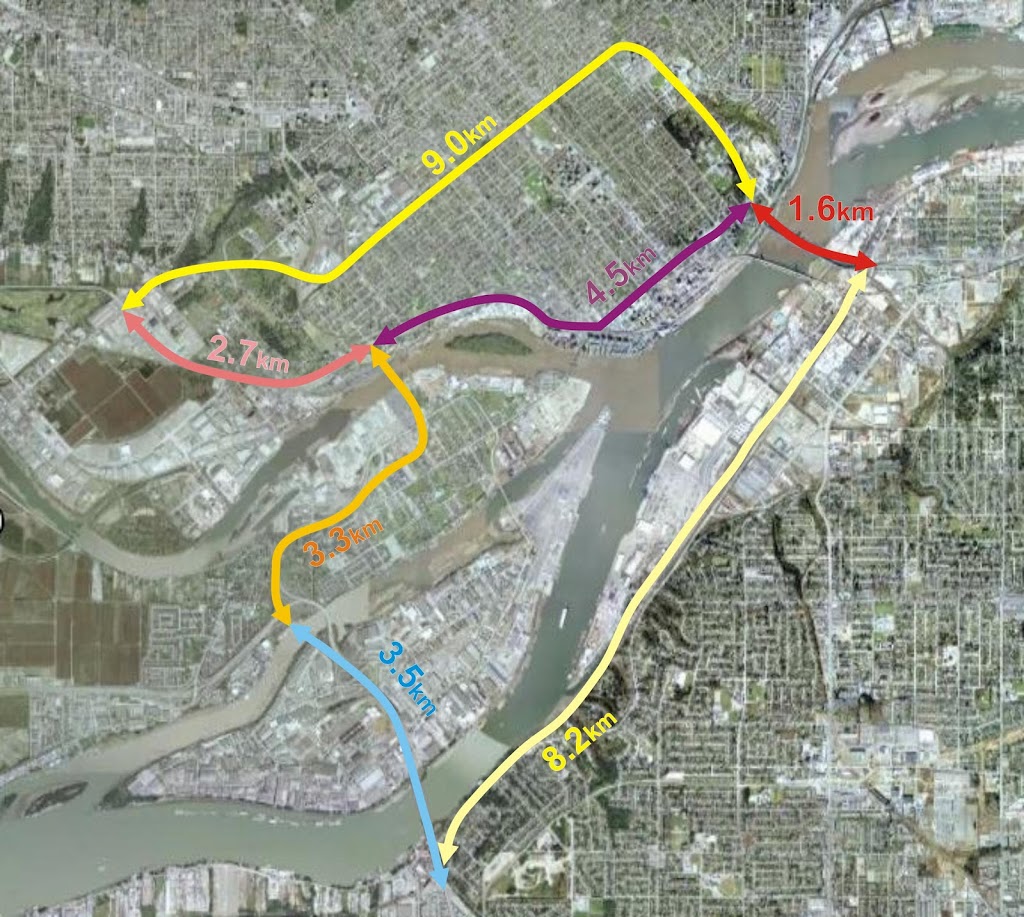
The first topic that was not up for discussion was the number of lanes. TransLink has determined they will build a 6-lane bridge with two of the lanes (apparently) dedicated to trucks only. No business case is made for this (for perspective, a transportation expert once opined to the NWEP Transportation Group that the difference between a 4-lane and 6-lane bridge could be as much as $300 Million). When pressed on the question of lane count, TransLink suggested 6 lanes was the only option on the table for “safety reasons”. The somewhat convoluted justification being that keeping trucks on the outside lanes keeps them from needing to change lanes on the bridge, or mix with the cars on the inside lanes, increasing safety for all users. That sounds good, unless you are paying attention. Take a look:

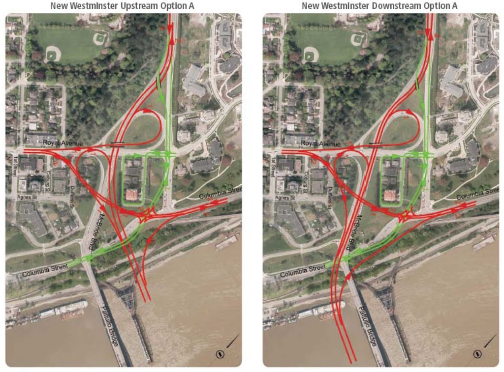
click to embigginate

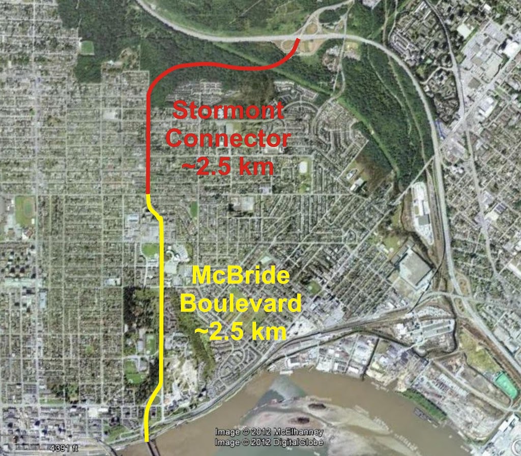
All of the designs deal with on ramps the same way, but I’ll use this one as an example, because it is first alphabetically.

Say you are Dave the Truckdriver entering New Westminster from Surrey, over there in the rightmost lane. If you want to go east to Highway 1, you take the first offramp, if you want to go towards the Queensborough, you take the second offramp, if you want to continue north towards Burnaby, you stay on the main route to McBride. All are options, as all are on the Major Road Network and designated as Truck Routes. It is unclear where the main route changes from three to two lanes, but it is presumably at the first or the second offramp. If it is the first, then you will need to change lanes before then (unless that is your destination). If it is at the second, you will still need to change lanes before that. Trucks going North will always need to change lanes. So lane changing is inevitable unless all trucks are forced to a single offramp going in one direction, but that would significantly reduce the usefulness of the bridge for “Goods Movement”, wouldn’t it.

The same situation happens for trucks heading south down McBride onto the bridge, or entering the on-ramps from the other roads, they are either going to have to change lanes to get to the outside lane, or merge onto the outside lane, and there will be inevitable mixing with cars. Oh, and cars using any of the offramps will of course need to move into the lane with the trucks in it, presuming the exit ramps are all on the outside lane. It is inevitable that cars and trucks will need to move lanes, and will need to at some point share lanes. Mixing of cars and trucks in inevitable.

This is the important part: These inevitabilities do not change at all between a 6-lane or 4- lane structure. The argument that a 6-lane bridge is “safer” is a complete wash.

The second point that was not discussed was the bigger picture around how we will manage the extra traffic once it exits the off-ramps of the bridge. TransLink pointed out one of the arguments against locating the bridge in another location (such as upstream at Sapperton Bar, downstream at the Tree Island location) was the integration with the existing road network. However, the current road network on the New West side is built to accommodate a 4-lane bridge, and already fails at times to accommodate that traffic load. Increasing the bridge by two more lanes will increase traffic capacity at the City boundary by 50%,. Currently, there is no plan to accommodate that. Think McBride is backed up northbound now? Think Brunette and Braid is an issue today? Think the Stewardson-to- Queensborough connection is a mess today? How will increasing traffic 50% to these locations help?  This is unfortunately and eerily like the UBE discussion again.

Tranklink responded to this saying: we’ll design the bridge first, then figure that out. Not surprisingly, few people in the room were satisfied with that answer. That answer shouldn’t be acceptable to anyone in the region who is funding TransLink; even those that believe building roads can solve traffic problems. TransLink wants to spend a Billion of your dollars to move a traffic pinch point 100m up the road. This is an example of a build-then-plan mentality that has them currently building a $4 Billion 10-lane Port Mann Bridge / Highway 1 Widening Project and a $1 Billion South Fraser Perimeter Road project, two major new Goods Movement routes that actually cross each other but do not intersect, forcing trucks to drive through New Westminster to get between them.

Oh, and that Billion dollars? That was the third topic not discussed. According to Translink, there is currently no funding source for the bridge. They are therefore presuming that it will be funded by tolls, likely through a design-build-operate concessionaire, much like the other 16 lanes of Fraser River crossing traffic that have been built in the last decade. They won’t say it is tolled, but they won’t say if there are any other sources.

This creates another area of uncertainty that needs to be addressed before we go any further. The BC Liberals have, as few as two weeks ago in that strange radio-interview-mini-throne-speech-event, suggested they are against tolling. The Mayor of Surrey doesn’t like tolls for this bridge. However, the senior governments are not lining up to dump a billion dollars on TransLink, and TransLink can’t raise taxes. So how are we paying for this thing? TransLink says let’s design it, and get approvals, and the money will arrive. One significant problem with this, of course, is that we cannot establish the business case or the demand for the bridge without knowing if it will be tolled.

TransLink representatives after the meeting admitted their estimates for future traffic demand on the bridge are based on tolls being collected. They provided some demand estimates based on population growth: increased vehicles from 60,300 today to 94,800 in 2041, but didn’t make clear in the presentation part that these estimates are based on a 6-lane, tolled bridge. How do these estimates change if we build a 4-lane bridge? Or if we don’t toll? Or if this same $1 Billion is invested in rails and/or SkyTrain for Surrey and Langley? Or are we, once again, just going to build it, then plan?

We have learned from the Golden Ears bridge example that tolls are effective Transportation Demand Management tools. People have avoided paying them, by driving around the long way or by reducing the number of trips. We have also learned from the Golden Ears that traffic estimates for tolled bridges can be overly optimistic (not the same story for new rapid transit infrastructure).

So without demonstrating the need for increased lanes, without explaining how these increased lanes will be accommodated on our already crowded and built-out streets, and without telling us how the bridge will be paid for, TransLink has taken to time to ask us which side of the old bridge we would prefer the new ramps?

Sorry TransLink. For some reason, the people of New Westminster are not feeling like they are “Part of the Plan”.