I haven’t written much here as of late, and I’m only here to say I’m not going to for a bit longer.
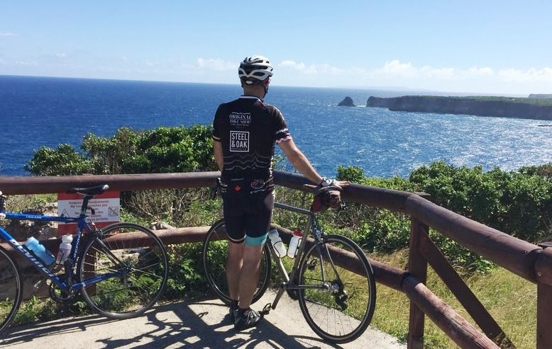
It was a busy last few months, and @MsNWimby and I have taken a vacation. We’ve relocated for a couple of weeks to some place sunny where we can ride bicycles in the morning, sit on a beach getting caught up on some reading in the afternoon, and spend altogether too much time staring off in to the distance and thinking about the plans ahead…
If you follow me on Facebook, you may see the occasional glimpse of my vacationary adventures. I’ll post if I feel like it, but hey, I’m on vacation.
Regular (or at least the usual semi-regular) programming here will resume early in January. I have a bunch of half-formed ideas for posts, a few things in the queue, and some ideas about next year, which looks to be a busy one. Also, there is some sort of electoral event arriving in October, the “silly season” for which has clearly already started. Alas.
In the meantime, I hope you are spending Christmas doing the things you love the most, with the people you love the most. See you in 2018.
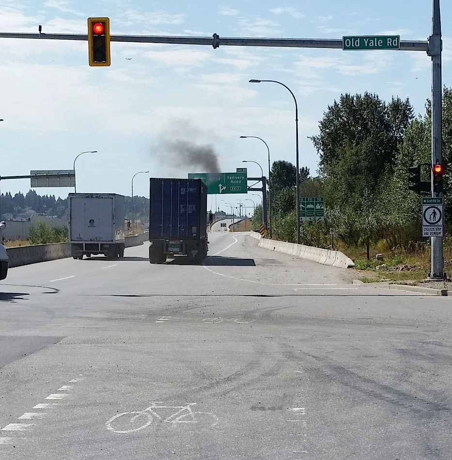
Bike lanes are in the news a bit again, here in New West, and out in one of our higher-profile western suburbs. It got me thinking about good and bad cycling infrastructure, and I haven’t gone off on a rant on this blog for a while, so make a cup of tea, because I am going to launch off on the Worst Piece of Cycling Infrastructure Ever®, known around these parts as the South Fraser Perimeter Road (“SFPR” or Highway 17). As this will most surely be tl;dr, you can skip down to the important part here.
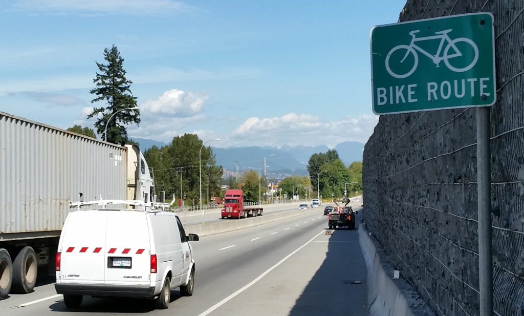
When some previous Minister of Transportation (Falcon? Lekstrom? meh, it doesn’t matter) was hyping the region’s biggest-at-the-time motordom project, loosely defined as “the Gateway”, they were quick to point out the benefits to cyclists. The SFPR was announced as part of the largest MoT investment in cycling infrastructure of all time. This hyperbole was supported by the entire ~40km length of this glorious new road having cycling lanes affixed.
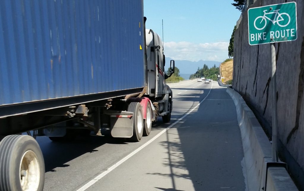
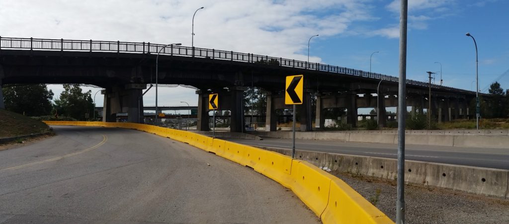
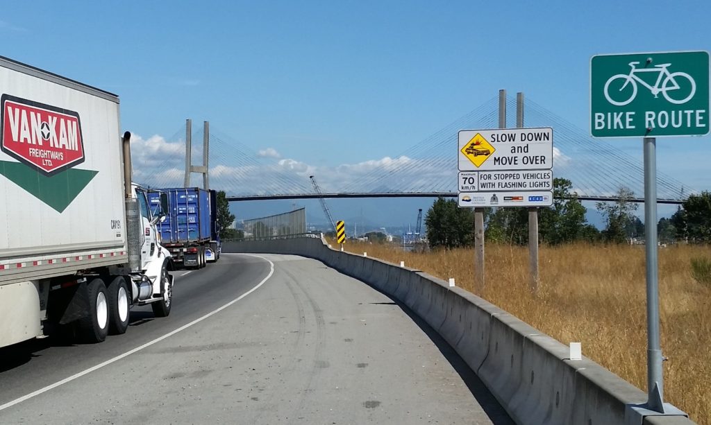
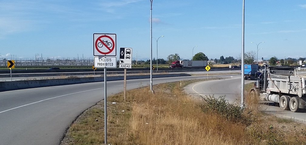
At the time, a few skeptics suggested that the shoulders of a high-speed truck route through farms and industrial areas may not be the ideal place to ride a bike, and by the time the new highway was opened, the previously-promised cyclist benefits were being seriously downplayed (hence all the dead links in that 4-year-old post above). But a Bike Route it is, to this day. There is a sign every 500m telling you so:
One of these green signs is found every 500 m for 40 km of great cycling infrastructure like this.
A couple of years on, the disaster of this poorly-placed, terribly-designed, and wholly-disingenuous cycling investment is pretty clear to anyone brave enough to venture onto this designated cycling route. No point dancing around the point: for cyclists of all skill levels, the SFPR is so unfriendly and dangerous that those “Bike Route” signs represent a reckless disregard for public safety.
That is a strong statement, so before I committed to it, I headed out to the SFPR with my bike to experience the length of the route in its harrowing glory, just to build up the temper necessary to commit that charge to hypertext. I went into it nervous, spent the ride terrified, and left enraged. Mission accomplished.
Funny I never ran into any other cyclists on this sunny fall day.
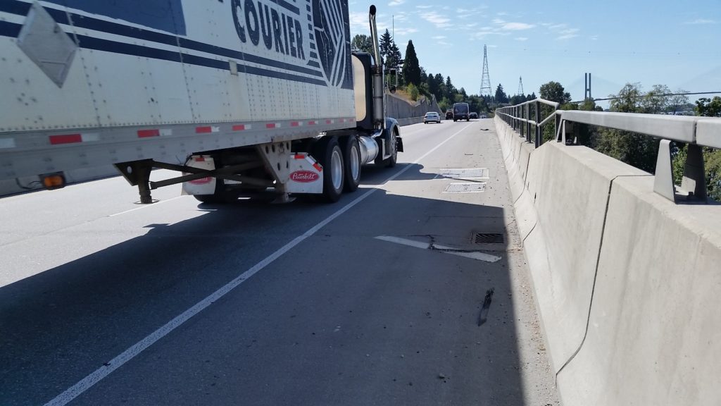
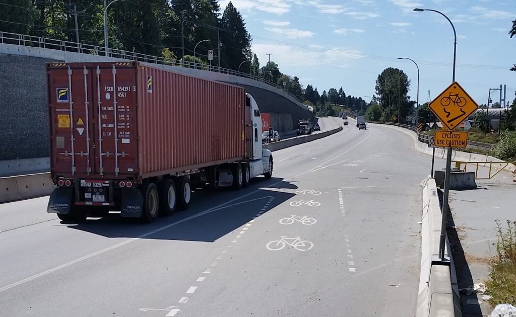
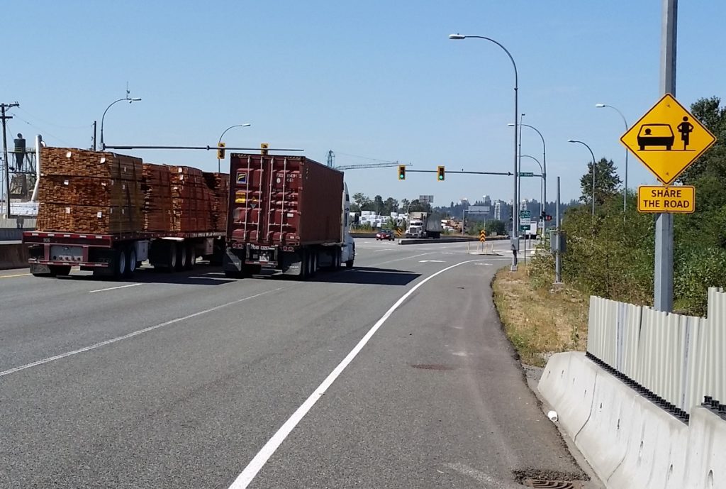
For the majority of the SFPR, the “Bike Route” is a 2.5 metre wide paved shoulder adjacent to industrial traffic moving at highway speeds. Nowhere is there a barrier protecting the shoulder from intrusions by trucks, not even rumble strips to warn drivers who may vary from their lane. The traffic is mixed, but the route was ostensibly built for and dominated by large trucks. The speed limit is allegedly 80 km/h, but speeds vary incredibly, from closer to 60 km/h around intersections (trucks accelerate slowly, after all, creating great rage moments for commuters!) to well over 100 km/h in the more open stretches.
Seriously?
In places where there is a soft shoulder or a low jersey barrier, having 80 km/h truck traffic blow by 2 metres from your left shoulder is unsettling. Where you are between those trucks and a 4 metre-high sound barrier wall (marked by the occasional gouge from vehicle swipes) or a 10-m concrete buttress, it is nerve-rattling.
shudder…
The knowledge that a momentary lack of attention by one of those drivers, or an impromptu swerve or technical problem with your bike means certain death provides a certain… clarity of thought. That thought is not “sure am glad I wore my helmet!”
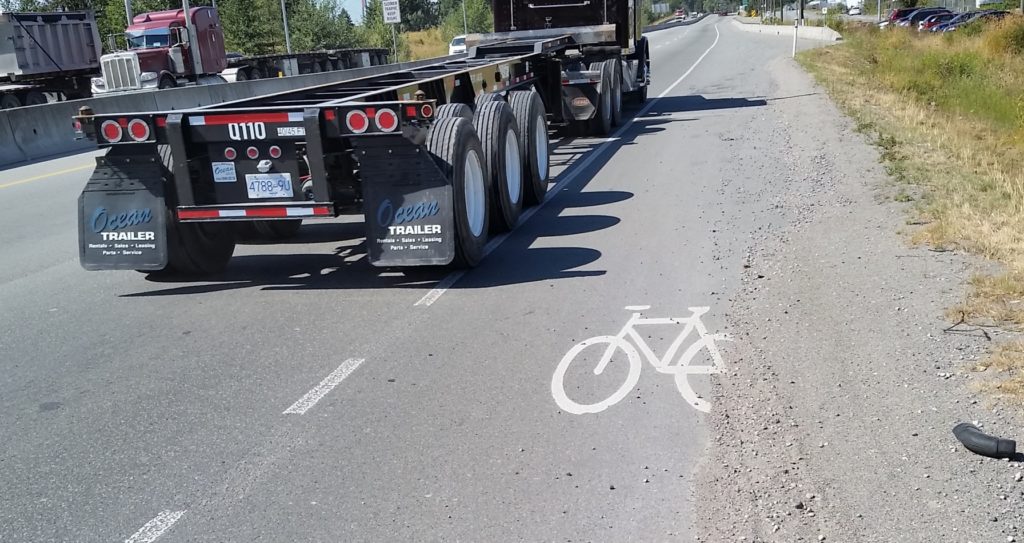
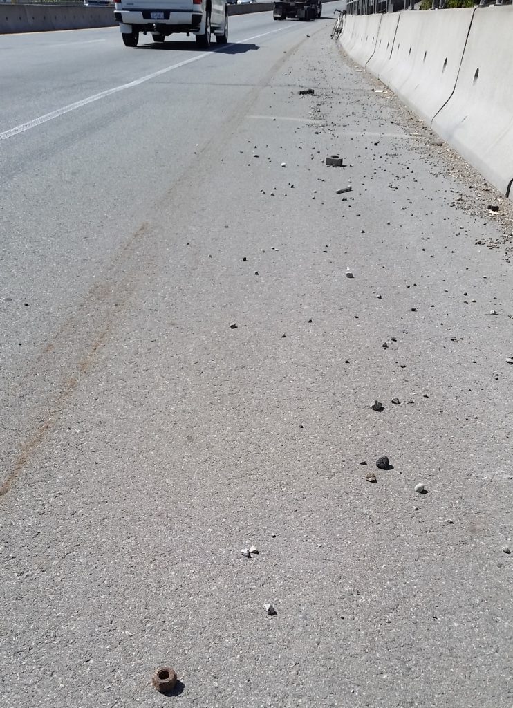
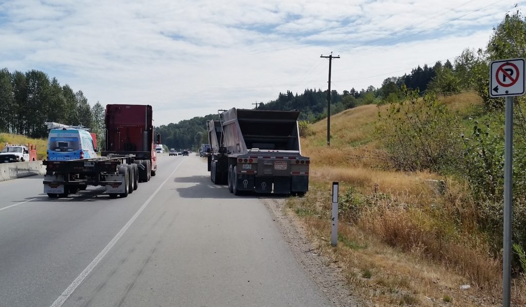
The rational move (other than to avoid the SFPR altogether, which I will get to later) is to squeeze as far over to the right and put as much space between your body and the trucks. The problem with this strategy is that the SFPR “Bike Routes” are dotted with particularly deep and treacherous rainwater catch basins, and the further you get from the traffic-swept white line, the thicker and more challenging the road shoulder debris becomes:
Rocks and a hard place.
The road debris on this route is not surprising for an industrial truck route, unless you are surprised by the raw number of rusty and broken bolts and other important-looking parts that are ejected from trucks. Debris encountered on my ride included rocks large and small, glass, plastic vehicle parts, kitty-littered oil slicks, random lumber, nails, tire carcasses, tie-downs and bungie cords, and the occasional dead animal. These only serve to heighten the chances of one of those life-limiting impromptu swerves or technical failures. Once you realize the “swept clear” parts of the bike lanes are only done so by vehicles crossing the line at speed that you start to wonder if the route is designed specifically to kill you.
I hope that speeding truck didn’t need those parts…
Or just designed to confuse you…
Seriously, what are they trying to do to us here?
To add another layer of frustration to this alleged “bike route” is its isolation. Choose the SFPR and you are stuck with the SFPR, because it largely fails to connect to an established regional network and actively prevents you from getting on or off the SFPR where these types of connections may be obvious.
There are two locations on either side of the Alex Fraser Bridge, where a perfectly safe, low-traffic road is separated from the SFPR (one by a tall sound barrier wall) in such a way that getting out of danger’s way is impossible. For lack of a connection here, crossing this 5 foot barrier requires a multi-kilometre detour.
That over there on the left is NOT a designated bike route.
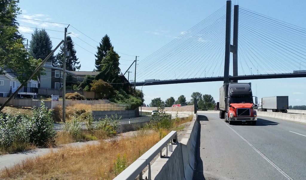
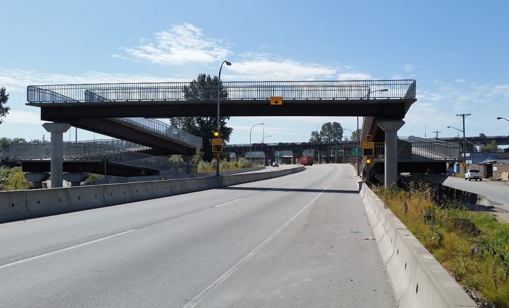
This lack of connection to regional cycling infrastructure is most obvious at the three regionally-important bridges under which the SFPR passes. The quality of the cycling paths on those three bridges is (east-to-west) really good, terrible, and not too bad, but they are all nonetheless important links. Again, either no connection has been contemplated for the bike route, or actual multi-layer physical barriers have been installed to prevent an SFPR cyclist from getting to the bridge where connections would be natural.
You can’t get there from here.
To get on the Alex Fraser Bridge from the SFPR requires a 3-km detour through two hairy multi-lane intersections. The Pattullo requires 1.5km and riding right past a pedestrian overpass, which would make for a great connection if it wasn’t barriered from access from the bike lane. The connection to the great bike infrastructure on the Port Mann is so far that is it actually a shorter distance just to ride to the terrible cycling infrastructure on the Pattullo.
Multi-layer protection – keeping cyclists from entering or leaving the SFPR at the Pattullo.
So the SFPR fails at every aspect of effective cycling infrastructure: it lacks the most basic safety and comfort considerations, it lacks connections, it lacks any form of appeal. It is not surprising that during my ride of the entire 40km length of the SFPR, both ways (done over two sunny mid-week days early in the fall), I never saw a single other person on a bicycle on the entire route. However, every 500m there is one of those little green signs. Or something like this:
Share the Road!
So it is time for the cycling community to wake up and recognize we got played. Of course, this is the Ministry of Transportation’s standard playbook, so we could have seen it coming: This “bike route” is a safety pull-off area for trucks.
One of these signs improves safety.
We were sold “cycling benefits” of a Billion-plus-dollar piece of transportation infrastructure, and got something else: bike signs placed on paved shoulder really intended to keep trucks in the other two lanes moving if the occasional vehicle needs to pull over, or of someone just needs to park a trailer for a few hours. Aside from that, it is a gutter for gravel and trash and carcasses and truck parts to prevent them from accumulating where they may impede truck travel. This “Bike Route” is just a part of the truck route, nothing else.
This is why this shoulder exists, signage be damned.
(I need to super-emphasize this) The SFPR it was never meant to be a Bike Route.
So what to do? I’d like first to call upon the new Minister of Transportation to take down those “Bike Route” signs.
It isn’t her fault, she didn’t create this mess, but she adopted it by getting elected, so it is on her to do the right thing. The MoTI must stop threatening the lives of cyclists. Removing the signs and anything else that may incite otherwise-unaware bicycle users from mistakenly entering this cycling abattoir. Put an end to the ruse that this is any place for bicycles.
I could ask her for many more things – investment in cycling infrastructure for Surrey and Delta to make up for the funding-securing lies told by her predecessors, a commitment to policy changes to prevent her staff from ever doing this kind of bait-and-switch again – but those are opportunities for the future, and will require budget and policy decisions and such. She is a busy person with a huge mandate and new to the job; there will be time for those niceties later. First we must undo this mistake made intentionally by the previous government.
In the short term, someone in Minister Trevena’s office needs to call up the road maintenance contractor that bought the rights to not clean the shoulders here, and ask them to send a crew out to remove those signs. It shouldn’t take more than a day, it won’t cost any money, and it’s the right thing to do.
Where the SFPR meets another truck freeway, cooler heads prevail.
We had a discussion at Council this week on the next steps for Truth and Reconciliation. As I noted in my Council Report, I didn’t support the staff recommendation to launch a Task Force to bring partners together and talk about an implementation strategy. I suggested that we may be headed down the wrong path, and need a bit of a gut check here on how we will engage this process.
First off, I want to make it clear I am not critical of the work staff have done so far, nor do I want this early course-correction to make it look like we are slowing the process or any less committed to it. Quite the opposite, I take to heart requests I have heard from members of our community that we go into this process with intention, and do it right. And that takes some explanation.
Every time we discuss reconciliation, I feel the need to put a big caveat before all of my comments: I am not a person who lived an indigenous experience. I recognize I have a whole bunch to learn about what that experience is, about what reconciliation means to people who have suffered under the residential school system and other forms of cultural repression that fill our history as Canadians.
Yet here we are, and with the best of intentions, I am another settler being asked to provide leadership over a process that is, fundamentally, not about my voice or my community.
Like many of my council colleagues, I attended an event a Douglas College last week where the intersections between local governments and the Truth and Reconciliation process were the topic. Again I left feeling that there is so much I don’t know, that I feel challenged in understanding where we even start. It was actually in discussions with participants after the event that some questions were framed for me in a way that got me to think about our path forward in New Westminster.
First off, we have a staff working group, charged with determining how our City’s internal processes and larger policies may need to change in order to fulfill our community’s commitment to the Truth and Reconciliation Commission Calls to Action. I think that is an important step, and within the structure of a local government, we need to do this. I have faith in our staff’s ability to interface our internal structures and regulatory frameworks with whatever comes out of the reconciliation conversation.
However, the proposed next step, forming a Task Force of internal and external people, first had me asking who would serve on such a task force, and what role does Council have on it. How would we decide on representation? Wait – why am *I* deciding on representation? Ultimately, this led to questioning if a Task Force is really the structure we want to use to answer questions – or even to raise questions.
One thing that has been bothering me since this Council opened the discussion about reconciliation is that every news story, every debate eventually ends up at talking about a statue. It seems that some think we need to deal with the statue, or take a few similar simple (but arguably very symbolic) actions like changing road signs, then the City can say we have done something and move on to worrying about roads and sewers and parks. And of course, the topic of the names of places becomes a rallying point for supporters and opponents of… well I guess what they support or oppose is pretty loosely defined, but “us” and “them” is at the heart of all of those arguments. It’s “their” statue, it’s “our” name, why do “they” not respect our position?
When I was discussing this the other day with a really wise friend, she asked me (and I paraphrase) what is reconciliation before we have truth? We need to first open up respectful discussion, and explore the truth of this community. Not about statues or place names, but about our experiences. To do that, we need to create spaces and opportunities for people to speak their truth. And those conversations may be very difficult.
As I was quoted (and again, I was paraphrasing someone smarter than me), a Task Force that meets once a month in an office and operates by Roberts Rules of Order in relation to a Term of Reference is about as colonial a structure as anyone can imagine. It is actually designed to avoid and get past difficult conversations in the interest of getting business done. The Witness Blanket visiting our community and the resultant conversations that happened at the Anvil and at kitchen tables around that installation, were a beginning to the conversation, but I don’t think the conversation is over. The bigger issue is – I don’t know how to write the continuation of that conversation into a Terms of Reference.
I don’t want to constrain those conversations with the wrong structure. We need know from the indigenous community what space they need to share their truth, and we need to allow settlers here in New Westminster, whether they arrived yesterday or are fourth generation, to equally share their truth. To be offended. To self-reflect. To learn.
We may end up putting together a Task Force at some point to make recommendations to Council, but we are not there yet. To get there, we need to get some people experienced in leading these conversations, preferably someone who has viewed this challenge through a lived indigenous experience, and ask them how best to connect with indigenous communities and the voices we often fail to hear. We need guidance on creating the space for that conversation. It may be here in New West, it may be somewhere else. It may be around a table, it may be around a fire. What is important is that we not ask our partners to fit into our space, or into our structure, The point is, I DON’T KNOW, and I argue few in the City do know.
So I moved that the Staff Working Group on Reconciliation seek an external consulting organization experienced in working on reconciliation dialogues to develop a communication and relationship-building process that all parties are welcomed to share their experience and their vision for reconciliation.
We are starting a journey here, and there is almost guaranteed to be bumpy points along the path, but we believe in the destination, and need to travel together.
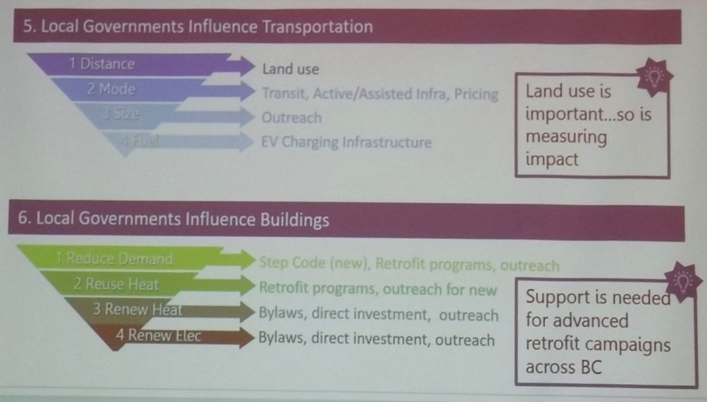
Concomitant to being on City Council, I am involved with more than a few other projects. Two of these are membership in the BC Municipal Climate Leadership Council, and Board Member of the Community Energy Association. These two organizations collaborated last week to put on the first Climate Leadership Institute conference in Richmond. If you are a New Westminster resident, you paid for me to attend, so here is my report on what you got for your 1/3 of a penny each.
(I feel I need to mention here that it was a pretty intensive program, and I have dozens of pages of notes, so I need to do quite a bit of distilling. Everything below if my filtered impression of the program, and may not reflect another person’s experience, and every quote is a paraphrase from memory or scribbled notes!)
This was an interesting 2.5-day event that brought together local government elected officials from across BC, municipal staff working in energy and emissions policy, and subject matter experts across the broad spectrum of energy efficiency and climate change policy. The format was a repeated pattern of a keynote presentation, a panel discussion, then an intensive break-out conversation where the participants could share their local successes and challenges related to the topics covered by the panels. This schedule drove collaborative thinking, shared learning, and more than a little inspiration.
The first session was on communications – how do we lead productive conversations on this politically difficult topic? Aside from some pretty useful self-reflection on how we are communicating personally and on the social media (Do we spout facts, or talk about our beliefs? Are we open to being wrong? Are you silent for fear of being judged?) we heard from some organizations who are learning how to effectively lead conversations: the Pembina Institute, the BC Sustainable Energy Association, Clean Energy Canada. We also discussed current communication challenges related to climate policy: How do you talk to a denier – or do you even bother? Does “Decongestion Charging” mean anything to anyone? With so much bad info on Social Media, how to react?
My takeaways from this were not profound, except in that I recognize I have shifted a bit on this blog and in public from speaking my passions to speaking facts and pragmatics. I think there is a space for the latter – I strive to be factual – but it is the first part that matters, and makes people want to listen to or read my ideas. I gotta get that passion back…
The second session was opened by former Premier and Mayor of Vancouver Mike Harcourt. He gave a pretty interesting “inside basebell” historic run-down of the politics of Greater Vancouver’s regional transportation and infrastructure planning, from Expo86 to today. He spoke of the politician’s paradox – the need to have a long term vision and also deliver in the short term to get re-elected so that vision can be realized. In the end, we all fail, but can move the baton forward, and good work can get done (or undone) by those with the ability to project a vision.
This led to a panel discussion on policy creation an implementation within complex (and often political) organizations. It was less about specific ideas (although some ideas I’ll talk about later arose here), and more about how to champion ideas through an organization as complex as a City. Do we make climate action part of a strategic plan? What happens when your strategic plan gets old (as happens quickly in this fast-moving tech-driven policy area)? What point to making new plans if you haven’t the budget or political capital to see it implemented? We also talked quite a bit about how we measure and report out the results of climate policy, in order to assure our staff are accountable to our council, and our Council is accountable to the public that elect them.
The third panel brought together energy managers from North Vancouver, East Kootenay, Richmond, Campbell River and our own New Westminster to talk about initiatives unique to each community that was making a difference in the their community in reducing energy use or emissions. We were presented a variety of policy tools, technology approaches, and strategies – including the successes and the challenges. I did note that New Westminster’s Urban Solar Garden got quite a bit of interest from other regions and communities.
We had a couple of powerful presentations on the future of global energy systems and on bringing the changes home to our communities in meaningful ways. I really need to write a separate blog post about this, because it takes us to interesting places. In short, the world’s energy economy is changing much faster than we ever thought possible. Canada’s National Energy Board, the agency that regulates the oil and gas industry and approves pipelines recently shifted their prediction of the year when Canada will hit peak oil. Last year, they said after 2040; this year they say 2019. Think about the meaning of that on every aspect of our economy. It’s happening, the only question is whether we will be ready. I’m looking at you, Jason Kenny.
On the last day, there were break-out sessions that explored in depth some of the topics not yet covered by the conference (in my case, we talked about food security, and the role that food systems play in our community energy and emissions goals). We also had presentations from the Provincial Government, the Federation of Canadian Municipalities, and the Real Estate Foundation of BC, all of who outlined grant opportunities local governments can use to develop studies, to implement new programs, or even for capital costs that will result in reduced energy use and emissions.
Finally, a theme I took away from the entire conference was one of timescales. On one hand, we need to think long-game in energy reduction and community emissions. We cannot replace our vehicle fleet in a year, or our building systems in a decade. On the other hand, things are moving fast. Electrical vehicle technology is growing at an exponential rate, as is building insulation and energy system technology. The prices for what was until recently “bleeding edge” technology are dropping fast, as China invests heavily in solar systems and vehicle tech is pushing storage systems forward. Where putting off infrastructure improvement was once fiscally prudent, the pay-back time for more efficient systems is shifting that equation.
As much as we need to think long-term, there has never a better time than now to take real action.
We are one year from voting in local elections, and based on increased activity in the local blogosphere and a perceptible sharpening of local social media jabs, we can safely assume the silly season has begun.
The more serious campaign news this week is that the provincial government has provided a heads-up on how to organize our 2018 campaigns. We knew there were going to be spending limits, but it is good to have some certainty on the ending of Corporate and Organized Labour donations.
New campaign spending limits based on the voting population were established early this year with amendments to the Local Elections Campaign Financing Act. In 2018 New Westminster, Mayoral candidates will be limited to about $45,000, and Councillors to about $23,000.
After some speculation, and more than a little uncertainty, the provincial government introduced yesterday proposed legislation to ban donations to local election campaigns by Corporations and Labour Unions. It is safe to assume that the Green Party will support the legislation (it is something they have called for), so we can now say the playing field for the next election is set.
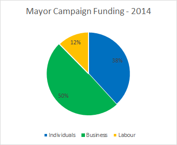
To get an idea what this means in New West, you can look at how money was raised last election. The data is available at the Elections BC site where financial disclosure forms for 2014 are still posted.
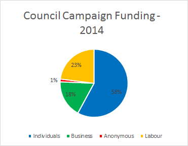
Starting with the Mayoral election, you can see that in aggregate, most fundraising was from businesses:
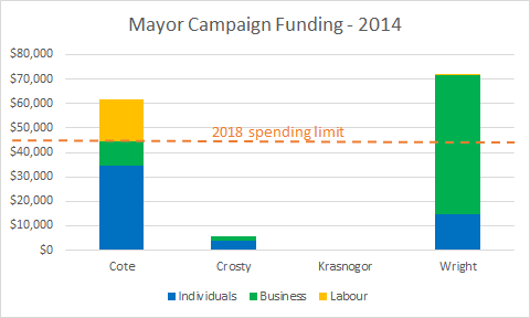
However, the main candidates did vary quite a bit in how they raised their funds. Candidate Cote, by far, collected the most from individual donations in 2014 (twice that of all other candidates), and received the bulk of available labour support (though only a little more than ¼ of his funding). In contrast, Mayor Wright received most of the business support, and was in turn mostly supported by businesses. Both main candidates spent more in 2014 than will be allowed in 2018, and neither collected enough from individuals to meet the proposed maximum spending amount.
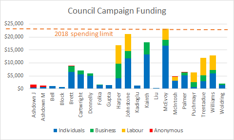
In aggregate, Council candidates collected most of their funding from individuals. Labour provided less than 1/4 of the funding, and business less than 1/5. (I’m going to avoid talking about the couple of candidates who were mostly “anonymously” supported):
Individually, only two candidates (yes, I’m one of them!) got even close to the proposed 2018 spending limit. Notably, both of us were also within the top 3 in fundraising from individuals:
Although the ranking of overall spending closely parallels that of fundraising from individuals, there is no doubt that the gap between the biggest and lowest spenders was widened by business and labour contributions. Based on that trend, it is probably safe to assume that the removal of so-called “big money” from local elections will result in more equality in campaign fundraising/spending. This is a good thing.
Maybe.
My equivocation is part of the reason why I haven’t taken a vocal side in the “Ban Big Money” rhetoric. I absolutely think it is a good thing in the long run for democracy, however I was elected under the old system, and received the benefit of business and labour contributions. Now I have a potentially bigger advantage: incumbency.
There is no doubt in council elections that incumbency is an advantage. One way to overcome that burned-in advantage is to raise more money and run the kind of super-organized and hit-all-the-bases campaign we all dream of running. It could be argued that having used a “big money advantage” to get a seat, my now campaigning to take that potential opportunity away from others is, well, self-serving. And that always made me feel a bit itchy about actively campaigning for this change.
In the end, this is where we are for 2018, and I’m glad we all have lots of heads-up about what the rules are going to be. Game on.
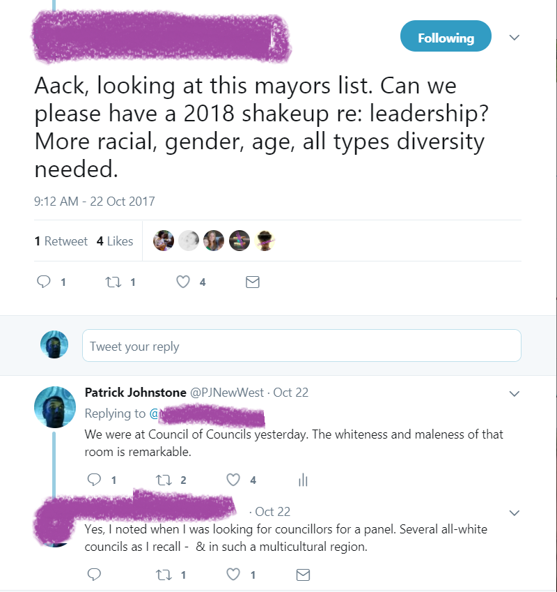
On Saturday, local government elected types met in North Vancouver for a Council of Council meeting. For a great write-up of what the meeting is and what we discussed, surf over to Nathan Pachal’s great South Fraser blog. I want to talk about another conversation that came out of the CofC.
At the event, Councillor Trentadue leaned over to me and made the observation (I paraphrase) “Crazy how little diversity there is in this room”. This lack of diversity was also noticed by others covering the event, noted in a few tweets:
I had an afternoon meeting for the Lower Mainland LGA, and side-bar conversations with a few of the Councillors continued on this theme, partly because some members of LMLGA are working on an event to discuss the general lack of “civility” in civic politics, and how that creates barriers to full participation. The story of Mayor Read of Maple Ridge announcing she will not stand for a second term was also fresh in our minds. It would be puerile to assume these issues are not interconnected.
But it go us to talking about the why. Is it the electorate not voting for diversity, or is there something structural in the job that prevents diversity? That seems like something that should be easy to figure out.
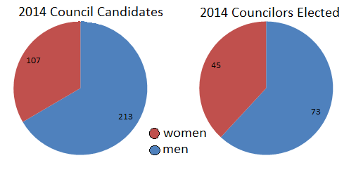
I quickly went to the CivicInfo 2014 election results database to ask the question – do we not vote for women, or are women not running? Of the 19 local governments in Greater Vancouver that report on the (binary, natch) gender of candidates (Vancouver and Bowen Island do not provide this data) for Mayor and Council, the data gives us this:
For Council, 33% of candidates were women, and 38% of those elected were women.
For Mayor, 16% of candidates were women, and 16% of the winners were women. Perhaps more tellingly, there was a woman on the mayoral ballot in only 7 of 19 communities (three were elected).
As a first-level approximation, we can suggest that voters, when given the opportunity, vote for women at least as commonly as for men. However, there are half as many women running for Council, and a paltry one-in-six mayoral candidates are women. If it isn’t the voter’s fault that local government is so dominated by men, what is it about the job that so biases those who apply for the job? I have my own suspicions, but maybe I’m not the right person to answer that question?
Unfortunately, there is absolutely no data collected on whether candidates identify as persons of colour, members of a First Nation, or have disabilities. It is harder to tell if it is the voters that account for the shade of the average Council of Council room.
I should note that it was pointed out to me recently (through a letter to Mayor and Council) that there is a general a lack of diversity in our Council Advisory Committees, and that the City does not appear to be taking any specific actions towards increasing that diversity (hey, apply for a committee now!). It is also recognized that the current Public Consultation and Public Hearing model is dominated by, well, the dominant demographic. I don’t have the answers here, but strongly feel we need to broaden public participation at the community level first if we are going to see more diversity in elected roles. Unless we do, it is hard to call our society “democratic”.
Long-time readers (Hi Mom!) will remember that I got involved in this entire blog thing through an environmental lens. When I moved my constant beaking off onto the internet back in 2010, I had been involved with groups in New West and regionally who were trying to promote sustainability and environmental protection, in my profession, in the community, and in politics.
At the time, New West Council was making significant shifts towards better environmental policy. A few of the newer members of Council, led by some young whippersnapper named Cote, were putting environmental issues on the agenda. The City was adopting environmental policies, hired an Environmental Coordinator, and was moving into developing a sustainability framework that would become Envision2032.
The City of New West considers itself a leader in environmental initiatives, however I have yet to see a local government that doesn’t consider itself a leader on this front. That may sound critical, but it is really more a reflection of the sometimes poorly-defined and always evolving concept of environmental sustainability. Local governments (like most organizations, and most people for that matter) emphasize the good things they are doing and progress they are making, but are commonly blind to the things they are not doing. When it comes to something like environmental sustainability, consistent re-evaluation of goals and metrics is the only way to avoid comfortable smugness.
Recognizing this, the City is inviting you to help us move forward on environmental policy. Council has asked staff to review what we are doing, and what we can do better – both a gap analysis and reality check. And we are asking you to help.
This week (October 25th!) there will be a Public Event called Royal City / Green City, where we are going to get people into a room to talk about where our environmental policies are, and where they need to be. We are bringing together some subject matter experts to provide inspiration, and perhaps to push us in uncomfortable directions. We will also be asking all attendees to react to what they hear, and push the City. It is completely free and open to everyone, whether you work, live, study or play in New West. We do ask that you register ahead of time so we can properly plan for the numbers who will arrive, because this will be an interactive event. You can register here:
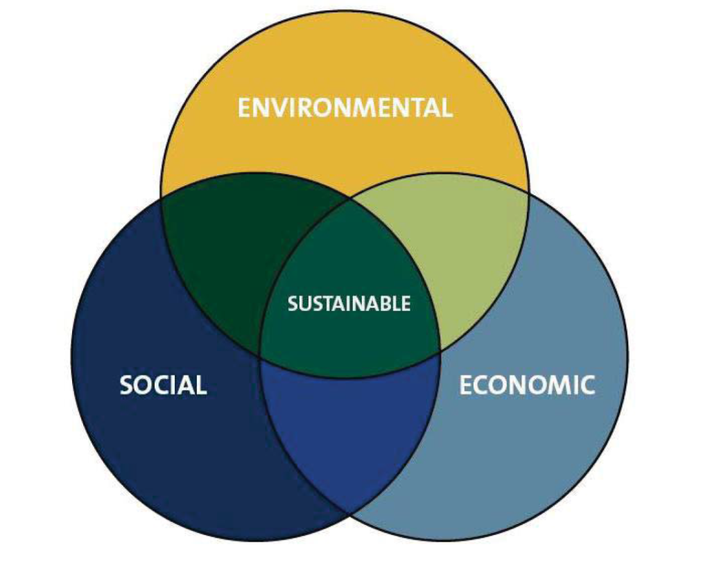
Maybe to get the creative juices flowing, I want to challenge the three- (or increasingly four-) pillar idea model of sustainability. This has become the standard model of suggesting sustainability is a balance between three competing forces – protection of the environment, growth of the economy, and maintenance of societal standards. Diagrammatically, it usually looks like this (copied from Envision2032):
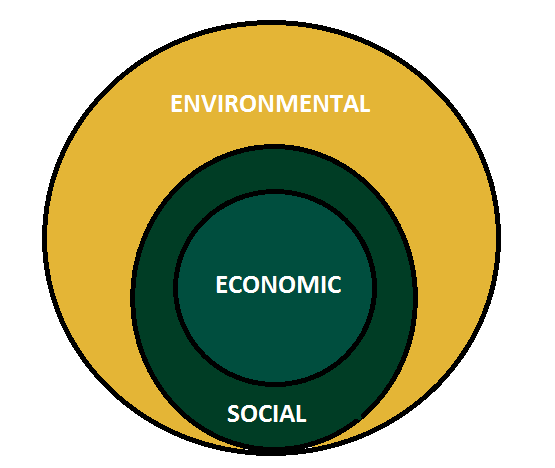
This has always caused me to itch, because I have never felt it accurately reflects the interdependence between the three pillars. Without a sustained environment, we cannot have an economy or a society. Take that one pillar away, the other two disappear. Similarly, our economy exists within, and is defined by, the structures of our society. It cannot exist without a societal structure, which is, in turn, defined by the environment in which we live. In my mind (and I’m not the only person to suggest this) the three pillars should be drawn like this:Actions, technologies, and organizations impact our economy, which in turn shape our society, which in turn impact the greater natural environment. When we shape policies, when we evaluate the worth of technology or price individual actions, we are using economic tools to adjust the shape of our society. If that re-shaping supports the protection of the natural environment in a way that doesn’t constrain future societies from access to natural resources, then we can call those actions “sustainable”.
Clearly, I’m not a philosopher, so come out on October 25th and tell me how I am wrong!
The most unusual Council Monday. Full of highs and lows.
It started out joyful with two great friends showing up to get married at City Hall (in a cyclist tradition going back at least to Moocher and Nancy in Breaking Away). They were married in the Mayor’s Office by my Council colleague who happens to be a Marriage Commissioner! I feel lucky to have met Jen and Simon through strange consequence of circumstances, and it was great to see their beaming faces on their special day. Good people.
A few hours later, all of Council was saddened to learn that a great friend and community leader in New Westminster had passed away from a pretty sudden illness. Bill will leave a big hole in our community, his contribution was huge. His career was saving lives, and his volunteer efforts were tireless. I feel lucky to have met him, shared many laughs, and to have taken his advice (although his attitude about maintaining a cleanly-shaved face was clearly a step too far for me). The only consolation this evening was in knowing that the community that he and Lynn spent so much of their time building is standing up to support Lynn at her time of sorrow.
Life is short, folks, but there is a lot of joy to be found in caring for others. And in the end, that’s all that matters.
This is part 4 on my reporting out on what I did at the 2017 UBCM conference. Part 3 is here
On the Thursday of UBCM 2017, I again caught the early train downtown for a morning clinic, this one on Socially Responsible Investing. The CAO of the Municipal Finance Authority and a gentleman from an Investment Management company came to speak to a pretty small audience about repeated calls from several local governments (including New West) towards divestment from fossil fuel industries.
Long story slightly shortened: most local governments in BC place most of their reserves in pooled funds held by the Municipal Finance Authority. Through pooling our savings, we can get pretty good returns, the investments are quite secure, and we can re-invest back into our communities – it’s a pretty good model. However, about 8% of these funds are invested in fossil fuel extraction companies, and another 4% or so in fossil fuel transmission companies – like the same Kinder Morgan that communities across BC are trying to prevent from fouling our landscape. We are paying to prevent Kinder Morgan from threatening the lower Brunette River, and at the same time, financing their fight against us. Many of our communities would like a better option – a fund where we can invest that doesn’t include that 12% of carbon-intensive industries.
The presentations were (alas) essentially a long justification for why this is not possible. Every tired argument against divestment was brought out, but the most bothersome was the industry-sustaining argument that the “fiduciary responsibility” of the fund manager will not allow them to make ethical decisions – they are required by law to return the maximum investment possible, and it isn’t up to them to make ethical judgement around climate change. This argument follows that it is up to legislators and regulators to remove impacts of unethical industrial activity, not the investor (which is strange, as *we are the regulators*, so our own investment is being used to battle our own efforts to regulate the industry). They also argue that it is difficult because we would need to divest from every industry that may produce greenhouse gasses like plastics companies and convenience store companies that share land with gas pumps… a familiar and bullshitty slippery slope argument. These arguments were, understandably) met with some pretty strong opposition from some members of the audience, but the circular reasoning used to prop up the oil industry is well lubed.
The MFA is attempting to put together a “Socially Responsible Investing” option for local governments, but are (perhaps not surprisingly) getting a lukewarm response, partly because the poorly defined and wishy-washy way the idea was presented to local governments. Altogether, a frustrating morning session.
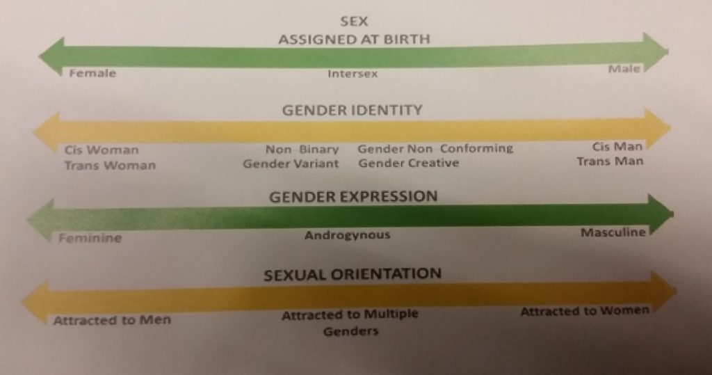
A much more positive experience was attending an afternoon workshop on Transgender Inclusion: Preparing for the New Reality. This was an interactive workshop about evaluating whether our local governments are integrating inclusion to our operations and our infrastructure. The “new reality” part is not that transgendered people are living in our communities (they have for as long as communities have existed), but that both the BC Human Rights Code and the Canadian Human Rights Act have been updated (in 2016 and 2017, respectfully) to include the protection from discrimination on the basis of gender identity and gender expression. So what used to be the right thing to do is now the law.
The session included a lot of training for those less familiar with the modern reality of cultural inclusion, as simple as defining the difference between birth-assigned sex, gender identity, gender expression, and sexuality. There were also representatives from Vancouver and Vernon, two BC cities leading the way in inclusivity. But mostly, the session left us with a bunch of questions to ask ourselves when we get back to our communities – how are we designing our spaces to be inclusive? Do our photos and written materials demonstrate an inclusive city? How are we addressing single-gender sport and arts programs? Do our Housing Agreements protect access for transgendered peoples? What are the feedback mechanisms we have put in place to make changes where needed?
We were also pointed to resources to guide our Local Governments (staff and elected types) to do more, and to do better. This was easily the best session I attended at UBCM this year.
Aside from these sessions, forums and workshops, the UBCM conference includes an Annual General Meeting, with things like Bylaws and Financial Reports and election of new Officers. These events occur throughout the week. There is also a Resolutions session which occurs on Wednesday, Thursday and Friday morning.
This year there were something north of 150 Resolutions on the Agenda for 2017. These resolutions are put forward by member communities, and are voted upon by the membership in an open meeting, some on a consent process, some debated on the floor. You can read all of the resolutions for 2017 here, although note not all were passed by the Membership. You can search the database of previous resolutions here.
This year there was a rigorous debates on topics as wide-reaching as the fate of the Martin Mars water bombers to repealing Daylight Savings Time. The only resolution New Westminster put forward this year came to the floor for debate on Friday morning. It was a call for action to prevent a renoviction crisis in our City. The text was:
Whereas the practice of renovictions, by which some landlords evict their tenants under the guise of performing major renovations and then significantly increase the rent of those units, is on the rise in our province; And whereas this practice is very disruptive to those impacted, including the elderly, low-income families, and new immigrants, and contributes to housing unaffordability and homelessness; And whereas municipalities are limited in their ability to address this issue and many tenants are unaware of their rights or are reluctant to exercise them: Therefore be it resolved that UBCM urge the provincial government to undertake a broad review of the Residential Tenancy Act including, but not limited to, amending the Residential Tenancy Act to: • allow renters the right of first refusal to return to their units at a rent that is no more than what the landlord could lawfully have charged, including allowable annual increases, if there had been no interruption in the tenancy; • eliminate or amend fixed-term tenancy agreements to prevent significant rent increases upon renewal; and • permit one tenant or applicant to represent and take collective action on behalf of all tenants in a building.
…and I am happy to announce it was passed by the Membership, after being well motivated by Councillor McEvoy.
There is one final aspect of the UBCM that isn’t really on the schedule, but is really valuable. It is an annual chance to network with local government types from across the province. I had great informal chats over coffee and/or beers with councillors from several other cities; told them my stories and they told me theirs, from dealing with internet trolls to frustrations of slow policy development to excitedly explaining how our City attacked a problem their City is having right now. Being a City Councillor is like any other job in that your cohort are often your best mentors and the best source of inspiration. They share your view and can see your challenges better than most. I always find inspiring people doing great work, and am re-charged by our conversations.
This is part 3 on my reporting out on what I did at the 2017 UBCM conference. Part 2 is here.
My third day at UBCM had less of an educational component, more of a political one.
One aspect of UBCM is an opportunity for Local Government elected types and staff to meet with Provincial Government elected types and staff, so we can raise important issues, lobby for support for our initiatives or programs, or learn about how provincial government programs are going to impact us. These meetings are arranged ahead of time, and with hundreds of local governments in attendance and only so many provincial folks to go around, the scheduling is pretty difficult. Meetings are generally 15 minutes to a half an hour, and rarely result in immediate action on issues – especially this year with a new government so early in their mandate.
Part of having a collaborative approach on Council that extends to working with senior governments, we split up responsibilities for these meetings among the Council Members attending UBCM, with the Mayor taking the lead at most meetings. I was able to take part in meetings regarding transportation topics, on the future of childcare in New West and the provincial role in supporting it, and on several community energy and emission reduction initiatives.
Several members of New West Council and a few of our planning staff also had a sit-down meeting with representatives of AirBnB. Clearly, AirBnB are working all levels of government in Canada to assure their business model is not regulated out of existence, and (unlike Uber), this is an area where Local Governments can exercise some regulatory control, through Zoning and Business Licensing. They came prepared to talk to any city who would listen, including providing local stats. In New Westminster (according to AirBnB, there are 130 active hosts, with the average host opening a room for 54 nights a year, for a total length of stay of between 4 and 5 days. The case they were making is that AirBnB contributes to the local economy (guests frequent local restaurants, pubs, and stores) and make housing more affordable for some people, by providing a “mortgage helper”.
We were pretty frank with AirBnB, we are concerned about the impact on our affordable housing stock, about violations of our business license and zoning laws, and about some livability concerns expressed by community members. We had a good discussion about other jurisdictions (such as Nelson and Tofino) and the strengths and weaknesses of their attempts at regulating this platform. It should be no surprise that some concerns that AirBnb raise about different regulatory models are very different that the concerns we hear in some parts of the community. There is also, I think, a bit of a disconnect between AirBnB’s interest in operating within a better regulatory framework, and the limits they put on how they could help local government with that framework- often citing (debatable) privacy issues.
This is a topic I am interested in, and am not getting a lot of traction in my calls for the City to take a more proactive approach. I think there is a role for supporting expanded BnBs in our community (Really, AirBnB is just a platform, not the core business), especially as we have so few Hotel Rooms, no “Hotel Tax” to support our Tourism efforts, and so many heritage and cultural aspects that should make us a popular destination. But with our rental vacancy rate below 0.5%, renovictions burgeoning on crisis, and so many challenges maintaining our affordable housing stock, the answers here are not easy.
Wednesday was also the first day of Resolutions for UBCM 2017 – but I’ll talk about those in a follow-up post.
The afternoon saw several “Provincial Cabinet Town Halls” which were an interesting model for engagement by the new government. There were four Panels (Health and Safety; Investing in People; Infrastructure and Economic Development; and Job, Resources, and Green Communities), each headed by 5 or 6 members of the new Provincial Cabinet. They gave a brief intro to their Mandate Letters, and where they see their files helping Local Government, then the floor was opened in a Town all style for us to grill them on any topic we liked.
I attended the Jobs, Etc. session, where the Ministers of Agriculture, Energy & Mines, FLNROrd, Environment, and Jobs&Trade were in attendance. The introductory conversations were pretty high-level, with Minister Popham clearly excited about protecting the ALR, Minister Mungall equally excited about the future of mining and green energy in the province, and Minister Donaldson proud of the provincial response to the wildfires of the summer (and giving significant props to his predecessor John Rustad for working hard to not let the transition impact firefighting efforts).
Questions given to the Ministers were wide-reaching, including yet another visit from the same Mayor from a certain agriculture-focused municipality clutching pearls over marijuana taking over prime farmland already overwrought with freeways and million-square-foot factory greenhouses (though she didn’t put it that way), to concerns about the future of northeast BC’s ample natural gas resources.
On that final point, I recognized a place where our senior governments are sending mixed messages. Where the Federal Government (in defending the Trans Mountain Pipeline Expansion) is saying downstream greenhouse gas emissions of pipeline products are not our problem, because they are burned elsewhere, the BC Government (including, alas, the new government) are insisting that we need to support LNG because it will reduce overall emissions in the downstream by offsetting coal in the target markets. Am I the only one who sees the contradiction here?

 For Council, 33% of candidates were women, and 38% of those elected were women.
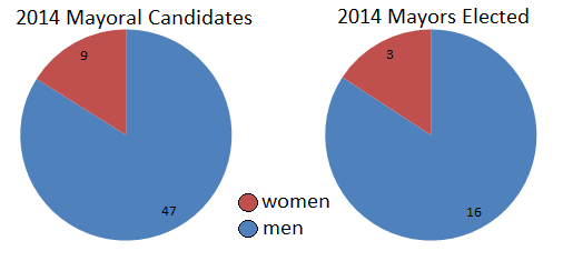 For Mayor, 16% of candidates were women, and 16% of the winners were women. Perhaps more tellingly, there was a woman on the mayoral ballot in only 7 of 19 communities (three were elected).
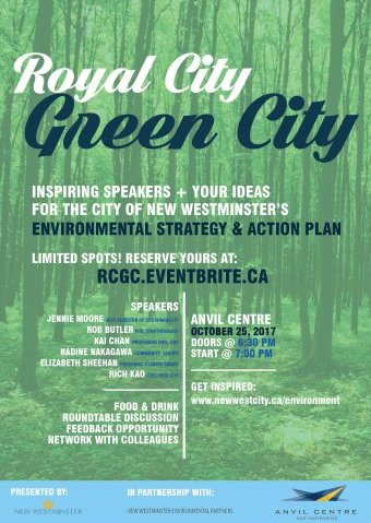
 Actions, technologies, and organizations impact our economy, which in turn shape our society, which in turn impact the greater natural environment. When we shape policies, when we evaluate the worth of technology or price individual actions, we are using economic tools to adjust the shape of our society. If that re-shaping supports the protection of the natural environment in a way that doesn’t constrain future societies from access to natural resources, then we can call those actions “sustainable”.