Right up front, I need to say the idea of having the Whitecaps’ second-tier team call New Westminster home, and having the first USL Pro team in Canada set up in Queens Park sounds like an exciting idea to me. I’m hardly a soccer fanatic, and have not attended a Whitecaps game since the new roof was put on the stadium downtown, but I am exactly the kind of guy who would buy tickets to see a pro soccer team operating in my hometown (as I would for a pro baseball team… but let’s not get off track here). A close friend of mine is a bit of a soccer fanatic, and is raising two pre-teen soccer fanatics, and when he found out New Westminster might be hosting a USL Pro team, he was immediately jealous (once again) of New Westminster.
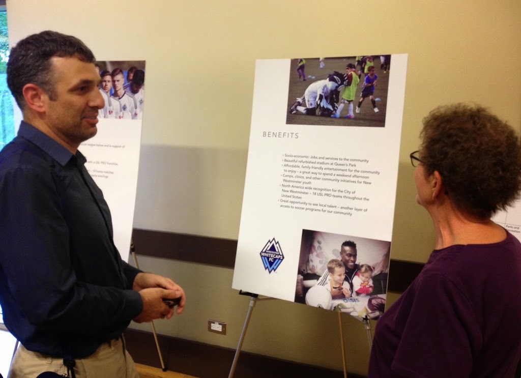
So safe to say, I went into the open house on Tuesday evening with a pretty positive attitude, and wanted to be convinced that this was a viable plan that the City could get behind:
Unfortunately, I left with more questions than answers. I don’t think any of my concerns are “deal killers”, but I am afraid there is a complexity here that will be hard to get through to everyone’s satisfaction before the (very short) deadline. Although I would suggest a slim majority of the people in the room shared my cautious optimism, I heard many concerns raised, and maybe I’ll take my typical topic-by-topic approach to these issues, but first a short summary of the proposal, as I understand it.
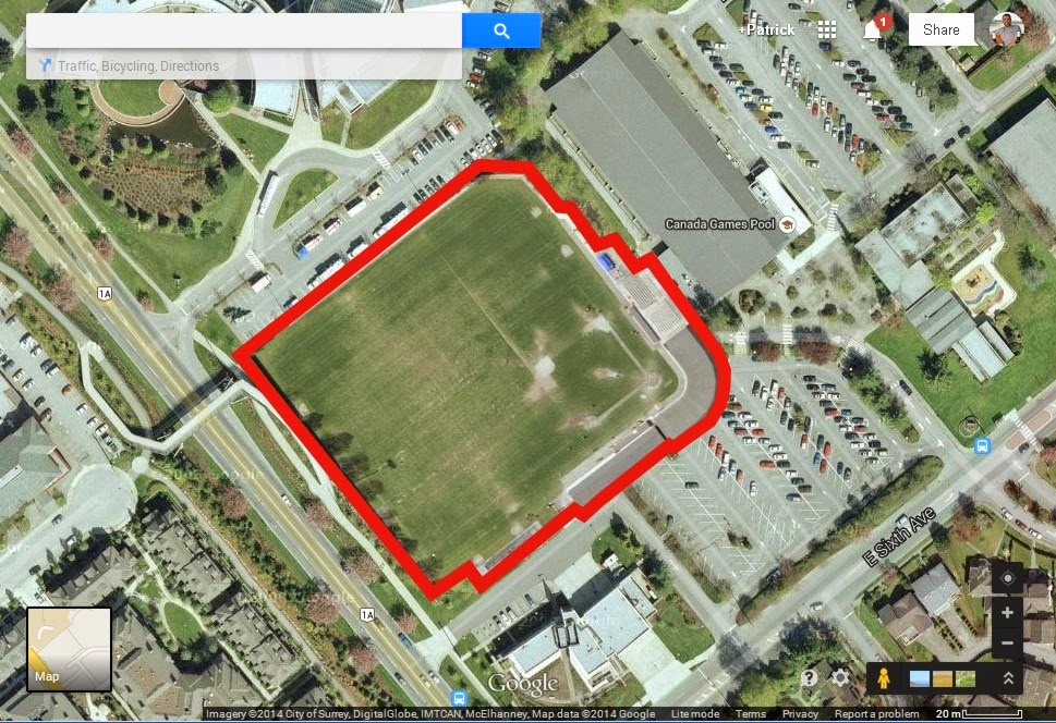
The proposal is to re-purpose the Queens Park Stadium, repairing the concrete section and expanding bleacher seats to hold 3,500 people, while installing a new soccer-only regulation field. There would also be new bathrooms, concessions, locker rooms, and ancillary buildings to support those 3,500 fans and two pro soccer teams on game day. There would also be a smaller “warm-up” field built about where the tennis courts and fill storage are now beside the Arenex. The (as of yet unnamed) USL Pro team would hold 14 home games a year here, and would have exclusive rights to those field at those times.
Now the issues:
Money: There was simply no discussion of what this will cost, and who is paying. The field changes and improvements will no doubt reach into the millions of dollars. As these facilities are being built on City-owned land, there are rules under the Local Government Act that must be followed. As the Whitecaps are a for-profit company (not a non-profit like other park users), they have to pay (at the minimum) “fair market value” for their use of public lands. Some sort of capital injection to build the facility along with a long-term lease deal will need to be worked out. Admittedly, I have no idea what that will look like, and there will be devils in those details. I am sure the negotiations around these numbers are going to be a key determinant if this deal gets done.
The spin-off value for the City is the second aspect of the financial equation here. There will be increased cost (policing, clean-up, traffic management, etc.) but these should be well offset by the spin-off financial benefits in jobs, driving customers to local businesses and that less-tangible benefit that comes with having your City named on the evening sports news with regularity and having pictures of one of the picturesque parts of our community beamed on TV around North America. One good detail that came out of the meeting was the commitment on the part of the City to have an independent third-party analysis of the economic impact of the proposal for the community.This will no doubt inform the property lease/capital injection math above, so the independence of the analysis is vital. See devil and details above.
Transportation: This was a commonly-discussed issue. With 3,500 people coming to 14 games a year, and only about 550 parking spots in Queens Park, the potential for parking chaos exists. Doing a quick scan of air photos, there are various lots around the Canada Games Pool and Justice Institute that are an acceptably short walk (1 km) from the stadium, and the Parkades of 6th and 6th are only a little further away (1.2 km). Ultimately, though, the plan will have to be for many attendees to NOT drive to the games. Between drawing a large number of locals, there is also a SkyTrain station only 1.2 km away. Sapperton Station is a little further, but a shuttle program to get people to these stations would likely be part of the plan.
In talking about getting to and from the games, I thought of Nat Bailey Stadium (5,000+ seats and only a few hundred parking spots), or Wrigley Field (40,000 seats and virtually no parking nearby). Build it and they will come, they say, but that doesn’t mean they need to bring a car. Yes, there will need to be a traffic and pedestrian management plan to reduce the impact on the Queens Park neighbourhood for those 14 days a year, but this is a manageable problem, in my opinion.
Neighbourhood impacts: That is not to say there won’t be impacts on the Queens Park and Victoria Hill neighbourhoods. 14 games doesn’t sound like a lot, but sports events in Vancouver can sometimes be loud and disruptive. The relatively pastoral setting of the existing stadium will change, and 3,500 people wandering the streets all hopped up on hotdogs, popcorn, and fight songs might be tiresome for many of the community members. This is a place where the Whitecaps organization is going to have to work with the very active Residents Association and nearby neighbours to assure complaints are addressed and problems managed before they become trends.
Fate of the Stadium: In the Queens Park Master Plan developed in 2012, it was suggested that they may knock the stadium down. It is an old building, and one in need of extensive repair. This was considered to be bad money after good by the City for a relatively unused asset (the field was well used, the stands were not). There was serious consideration of removing most of the stadium building and having a more open ballpark design. This plan will actually “save” the stadium, but upgrading and expanding it. It will also result in the building of an adjacent all-weather field, and (see below) a replacement baseball field. Presumably, these fields will all be useable by other community groups and the general public on the 350 days of the year when USL Pro teams are not using it.
One interesting discussion I had was with a Queens Park resident talking about the (my term, not his) Social Licence implications of allowing a for-profit corporation use City-owned park space to make that profit. It is an interesting topic, and I could only think that there needs to be a demonstrated good for all of the residents of the City, be it a financial gain for City Hall (and the taxpaying residents and businesses) that outweighs the lost opportunity of the space. I am sure there are people who will never be happy with an arrangement like this, and I’m not sure that philosophical debate can be solved on this issue alone.
Baseball: Of the vocal opponents at the meeting, it seemed to me the members and supporters of the New Westminster baseball community. The existing stadium is the only “full size” baseball facility in the City. The New Westminster Baseball Association have invested energy and money into making it an exceptional field for long-ball, and don’t want to lose that investment. There was a lot of discussion of moving the baseball field elsewhere, but that’s not an easy proposition. Aside from the cost of building a high-quality baseball facility and moving things like lights and batting cages, there is a simple geography problem. A “full size” baseball field requires a square about 400 feet on a side, or a 1.5 hectare square (to fit ~350 foot foul lines, a ~400 foot centre field, and ancillary buildings behind home plate). People suggested a few locations, so I played a bit of cut’n’paste with GoogleMaps images of the existing field to see what a relocated field would mean to the few existing park-owned spots in the City:
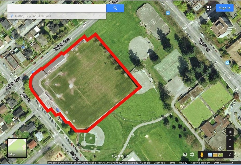 |
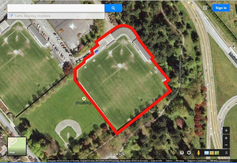
| Moody Park – the Stadium footprint is much larger than Justin Morneau field. |
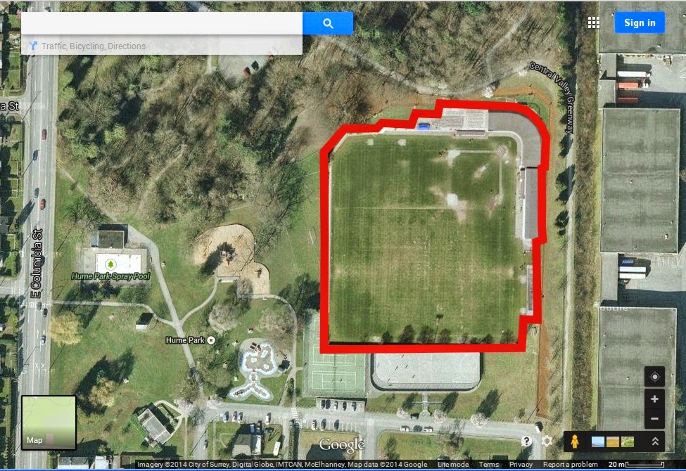 |
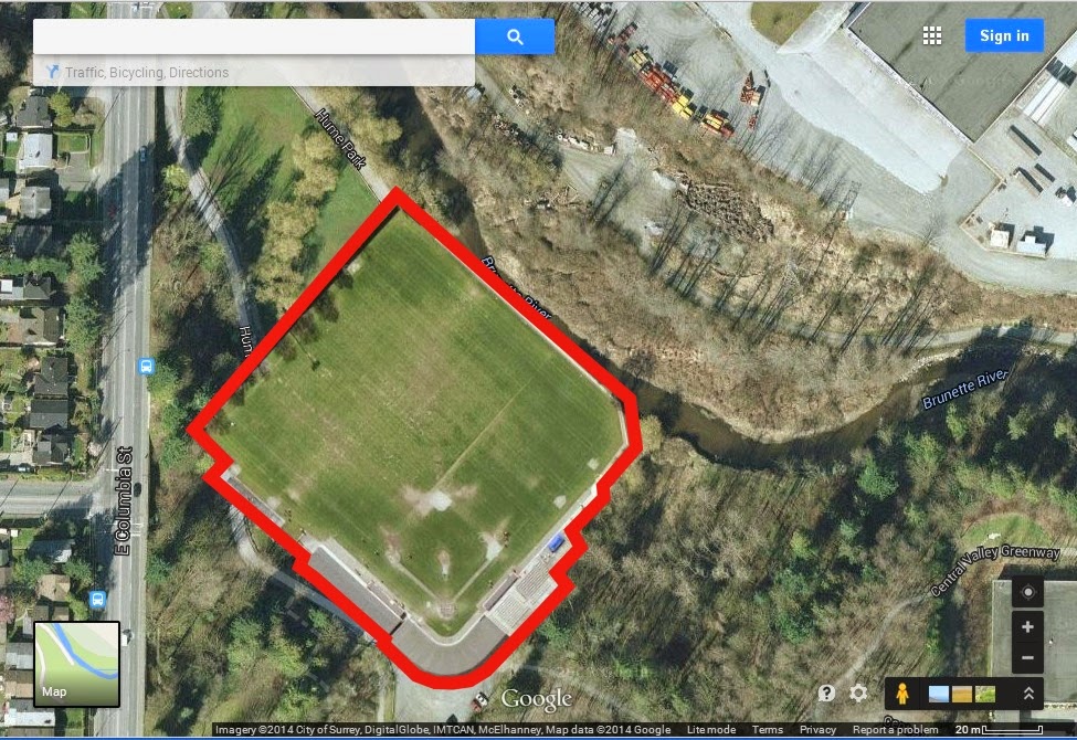
| Upper Hume might be a tight fit, if we removed other facilities. |
 |
| There just isn’t enough room in Lower Hume |
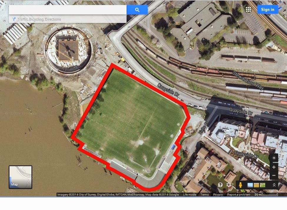 |
The currently no-quite-completed Muni Evers Park is also a tight squeeze,
with a bit of a water problem on one side, and road problem on the other.. |
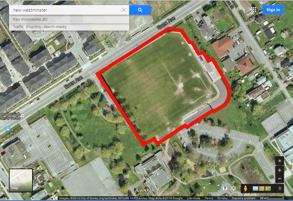 |
This is the biggest space in Queensborough, but the existing powerlines probably
make this a non-starter. |
It is only when you try to find an empty 1.5-ha space in New Westminster when you start to realize just how compact our city is!
The idea of just putting the field behind the proposed new soccer field is the one that was suggested as most favourable for the proponents, and might be the only place in the city where the field would actually fit without taking too much dedicated space from existing facilities:
 |
| Note, this is my depiction, based on verbal description, and not the official plan. |
Fortunately, even this issue appears to not be a “deal-killer” as long as there is a plan in place to have a field ready for NWBA to use before they lose their existing field.
So where from here? There is another open house next weekend (August 9th), where hopefully a few more details will be available. After that, time is short for Council to approve this very complex plan by September 15, which is required for the Sappers to be included in the 2015 USL Pro schedule (see what I did there?). So go to that open house if you missed the first, and fill out the on-line survey here. It is early yet, but we need to get the right questions in now so they can provide us the answers we need to make this thing work.
Despite the tight deadline, this should not be your only opportunity to listen, learn, and provide feedback. I heard suggestions at the meeting that Council might decide to have a Public Hearing-type meeting before the September 15th decision is made. As much of the detailed negotiation over real estate terms will be (necessarily and completely legitimately) in camera, we may not know the full details until that Public Hearing. So until then, right me down as somewhere between cautiously optimistic and optimistically concerned. I need to learn more.
UPDATE: As irascible commentor “Anonymous” pointed out, I missed one potential spot – the all-weather field between the Justice Institute and the Glenbrook Firehall. This is actually a pretty good spot for reasons my unknown critic points out, and it just fits the footprint: