Long winded weekend.

It was a long, long weekend. Mostly because people at the curling rink, the River Market and the pub were badgering me about this profile in the Record.

It is hard to talk about yourself and not sound like a narcissistic blowhard, especially when you are a self-aggrandizing blowhard like me, but I think it turned out pretty well. I figured if people wanted to hear me complain, they would come to this blog, so I tried to emphasise the positive in that interview. And as cheesy as it may seem, I really do like this City, for a lot of good reasons.

For example, a few people complain about missing crosswalks at a busy intersection, and guess what happens. A few days later, someone was out there with some white spraybombs putting some white lines down. It wasn’t fancy, but it worked! I’m not even sure if it was someone from the City or just some random community rabble, I kind of hope it was the latter, even though it makes me feel bad for whining about the problem on the internet and not going out there and doing it myself…

Then, on Monday, the City was out there in earnest, putting real reflective crosswalk paint down. They didn’t do a fancy job, but a temporary fix was all we needed, just to keep the crossing outside of a popular pub safe during the Canucks Playoffs, and until the final pavement cap can be put down on 6th. Thanks Guys!

True to the profile in the Record, I spent the weekend doing three things: Curling at the DonSpiel, Rabble-rousing, and working on my garden.

The DonSpiel is the season-wrapping fun tournament at the Royal City Curling Club. This is a bonspiel devilishly designed by long-suffering Royal City club member (and 2012 Mens League Champion Skip!) Don Smith, to squeeze the last bit of fun out of the season. The format brings novice and experienced curlers together and emphasises the off-ice-capades as much as the curling. It is a legendary good time… Oh did I laugh.

The Rabble-rousing part of my weekend was the glorious sunny Saturday I spent at the Royal City Farmers Market outside of the River Market at the Quay, catching the first tender sunburn of the season while talking to people about the Master Transportation Plan and the Pattullo Bridge consultations with some of the New Westminster Environmental Partners.

We were mostly handing out these:

Because that is our message right now: Show Up and Be Heard.

Based on some conversations we have had with people in the know, the Pattullo Bridge thing is coming on fast. The City is looking to the MTP process to get the voice of the people of New Westminster to take to TransLink, but TransLink has made their intent clear: They want to build a 6-lane bridge, increasing the daily traffic load entering New Westminster from Surrey be 50%, and doubling the truck traffic, with little regard for how that will impact Royal Avenue, McBride, or your neighbourhood.

The consultation has not presented the business case for or against the myriad of other options, nor has it even taken a cursory interest in the transportation plans, policies, or vision of New Westminster. Anything other that the single plan they have presented is not being considered. There are many in the City who suggest this is not true to the nature of “consultation”. Some of these groups are getting organized.

The Meetings on May 3rd will give the people of New Westminster a real opportunity to be heard on this issue, and the City needs as many people as possible to show up. Even if you think all of my opinions on the bridge are those of a crackpot, or the opinions of the NWEP are complete bunk, you still need to come to one of the City’s Open Houses. This is, most likely, your one and only chance to be heard before TransLink charges ahead.

Save the date. More to come.

When is a plan not a plan?

…and when is an announcement not an announcement?

It is pretty clear the BC Liberal brand is in a bit of trouble, and the new packaging is not working out as well as planned. Premier McSparkles’ telegenic smile has not been enough cover for the general lack of direction displayed by a Government that is looking a little past its due date.

I am not a member of any political party, and usually vote based on the value of the local candidate (although, I have to admit, the Federal Conservatives could run the resurrection of Mahatma Ghandi locally, and that wouldn’t be enough to win my vote at this point). I have met both Judy Darcy and Hector Bremner, the presumed local NDP and Liberal candidates in the next Provincial election, and they both seem like good people with their hearts in the right place; I have no reason to believe either wouldn’t serve our community well.

The new Premier was an unknown coming in. In contrast to Kevin “strip it down, pave it over, sell it off” Falcon and Rich “Darth” Coleman (both who give ample reason to vote the other way), there was not enough substance to Clark to make me want to vote for or against her, despite her merging skills. In the end, it appears that apparent lack of substance was masking a much deeper and more profound lack of substance.

Yet like most people in an abusive relationship with an authority figure, I keep waiting and hoping for the BC Liberals to come up with just one Really Big Good Idea (RGBI) that will put them back in this race. And I keep waiting.

Regular reads here (Hi Mom!) will know that I am way more interested in transportation issues that is, frankly, healthy. So this week when the Premier rolled out her “Pacific Gateway Transportation Strategy” this week, with the by-line “Moving Goods and People”, I thought OK, maybe this is the RGBI. By the announcements, it sounded like they are committing a bunch of money, working with major partners, and are going to deal with the major transportation issues in our Province!

Surely (thinks I) this includes improvements to short-sea shipping, like suggested back in 2005 in a report prepared for Port Metro Vancouver, to finally remove some of the container traffic from our roads and reduce the unsustainable use of trucks to connect major trans-shipment locations. Maybe they will finally include a strategy for high-speed rail, to integrate with the west-coast high speed rail network our Southern Neighbours are planning? Maybe they will finally outline plans for rails to the valley, and upgrades to the Westminster Rail Bridge? Surely, it will include a review of TransLink governance, and a sustainable funding model for TransLink to meet its mandate outlined in Transport 2040. Maybe even (pinch me) an integrated Transportation Demand Management Strategy? A reasoned regional approach to tolls? Where is the Big Plan that shows leadership in Transportation?

Alas, like a Who on Christmas morning, I found nothing under the Christmas Tree that looked anything like Leadership. Even the lump of coal in all our stockings has already be been reduced to atmospheric greenhouse gas.

First off, there is the money committed. Transportation requires infrastructure, infrastructure costs. The plan offers “$25 Billion in total investment… by 2020, beyond the $22 Billion previously committed”. If you go the back pages of the plan document, where the numbers are, you can total up the money committed to $34.7 billion. That sounds like a lot of government investment in getting people and goods moving.

Except that more than $28 Billion (more than 80%) is private money, the lion’s share being a projected $18 Billion to be spent by mystery funders to build mythical LNG plants in Kitimat. The rest? $2.8 Billion in rail line growth by CN and CP, more than $4 Billion in Port Expansion in Vancouver and Prince Rupert, and $1.8Billion in Airport Improvements. All three of these, one should note, are federally-regulated lands and industries, so the Province has less than nothing to do with them. It couldn’t stop them if they tried. After that, private money will be used to build a smattering of privately-funded road works to improve access to mines and oil and gas fields.

OK , so what of the $6.7 Billion that is Government spending? Most of it is wrapped up in the Port Mann 2 and Hwy 1 Widening project ($3.3 Billion) and the South Fraser Perimeter Road project ($1.3 billion). Really, you are re-announcing, yet again, the PMH1 and the SFPR!? Again? This is meant to excite us? Throw in another $1-2 Billion on various ongoing already-announced and well underway highway projects (Kicking Horse Pass, etc.), and we are looking at a grand announcement of…no new investment in transportation.

Then we can look at the various uncosted parts of the announcement/plan. Things like “cap the property tax on designated ports”, and “eliminate jet-fuel tax for intern ational flights”. No indication what these moves are going to cost us, probably because cost accounting on tax cuts is really not this government’s strong suit.

Oh, and that other part of Transportation policy? The less feel-good parts about zooming trucks and vrooming planes? Strangely absent. This strategy is outlined in an 11,000-word document, but there are some words missing. Like “carbon”. In their defense, “climate” appears 7 times in the document. The only problem being that 6 of those times, it is used in the context of “building a climate for investment”. The time it is mentioned in the context of “change” is in the little sidebar about “the environment”, notable as it is also the only time the words “green house gas” and “emissions” are named. Here, they demonstrate their commitment by re-announcing, two years later, the Canada Line (a rapid transit system that was overcapacity the day it was built), and, yes, the Evergreen Line. No mention of a $30Million gap though. The word “Translink” is not raised.

But rest assured, the Environment is important. If you listen really carefully, you can hear the birds chirping over the mid-tempo rock with vrooming-and-zooming soundtrack of the splashy announcement video, right when the word environment appears. You can’t make this shit up:

Just like this big-images, low-content video, this government has once again displayed they are all about show, with no substance at all. Premier McSparkles appears to think re-announcing Kevin Falcon bad ideas and doubling down on the hating teachers is the path to success.

What should be telling is that neither John Cummins nor Adrian Dix are making too much of splash of opposing her ideas or announcements. When a government is sinking this fast and the Premier is busy bailing water onto the boat, you don’t want to risk distracting her from the task at hand

Plaza 88 – The Good, the Bad, and the Industrial.

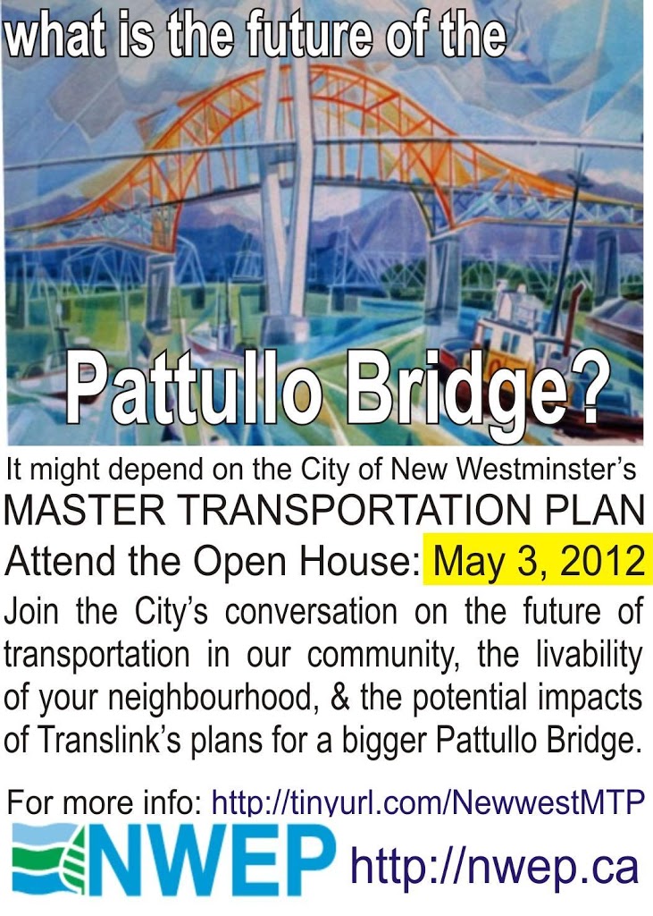
There is no more prominent symbol of the renaissance on New Westminster than the Plaza 88 Residential / Commercial / Entertainment / Transit complex. This cornerstone project is not only the largest single residential development in New West, it is also a new gateway to the City at our namesake SkyTrain station, and regionally significant in the way it integrates retail space with a transit node.

As the residential buildings are completed, the anchor retail tenants are open, and the rest of the space is starting to fill up, I took the opportunity to wander around the Site this weekend, to see how it is filling in. The much-anticipated theatre complex and the retail at the Skytrain level is still a few weeks (months?) off. Clearly, some re-jigging will be necessary with the wedging of FalconGates into the otherwise open plaza, but we have enough of the project completed that I thought it was worth taking a closer look around, and getting a sense of what the project offers as an open space. It helps that the CIBC was holing their little Grand Opening Shindig so I could get a free hotdog and a brush with greatness:

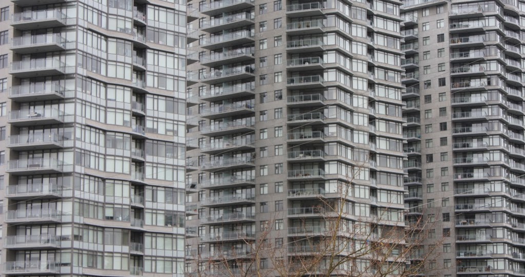
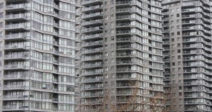
First off, I can’t really declare myself a fan of the residential towers. They are big, out of scale with the surrounding high rises, they are close together, and they are a unique mix of standard-issue-glass-wall-small-balcony-vancouver-condo-tower and bare-concrete-slab-sided-soviet-design-bureau designs that add up to pretty unappealing.

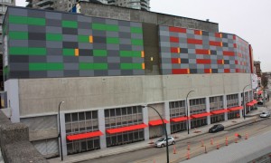
Pretty much the entire building complex, from the outside is unattractive and oversized. The imposing 8-story parkade looms over and shades out Carnarvon Street, although this may eventually be softened by the green wall design and opening of the live-work spaces at ground level. The view from the south is also a rather imposing 8-story concrete wall, with the notable exception of the Art-Deco Façade from the old Sally Ann (which I like), and the brash pattered red and green wall covering (which I am still unsure about). I did manage to decode the message hidden in the pattern on the red/grey part of the wall, but the pattern on the green/grey side is either nonsense, or I am missing something… CSFAO?

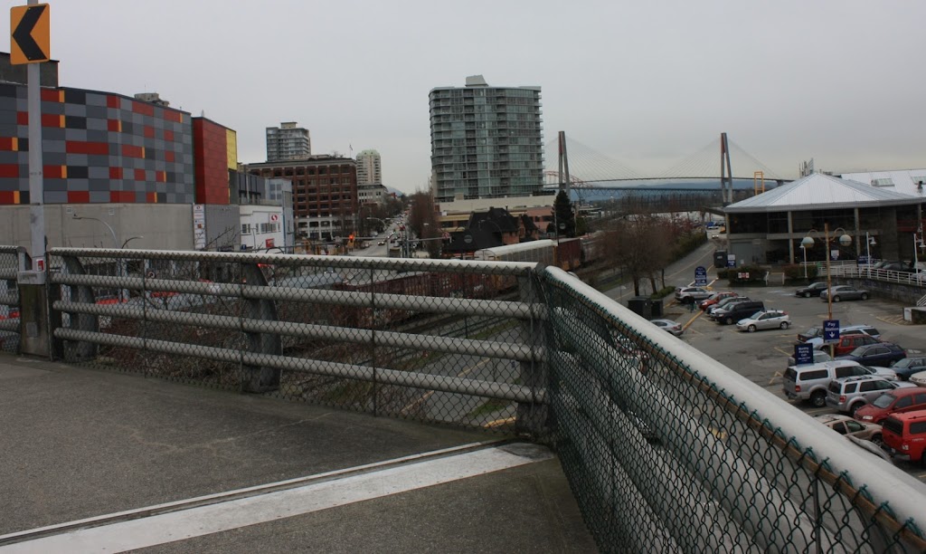
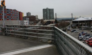
While looking at the wall from the Quayside Drive overpass, I was reminded about yet another “missing link” for pedestrians in New West. From the west exit of Plaza 88, you are only a few hundred metres from the River Market, but the overpass curves west, making it a much longer trip. A staircase on the southeast corner of the overpass would create a much shorter link between Plaza 88 and the River Market, but I digress…

No, wait, I don’t digress. One of my biggest pet peeves with the Plaza 88 project is that it is, on the outside, a pedestrian disaster. The pedestrian mall around a SkyTrain station is a great idea, but anyone trying to get to or from or around the complex is met with horrible pedestrian space. I have already wailed and whined about the east exit, where the primary link between Plaza 88 and the rest of the commercial enterprises on Columbia Street was designed to accommodate trucks and cars, at the cost of being completely unappealing and likely unsafe for pedestrians. The south side has a wide sidewalk, and 100m of concrete wall and parkade cages…, with intermittent awnings of questionable value. The Carnarvon Street environment is crowded, with a bus loop and multiple garage entrances, inadequate cross walks, and will be loaded with busses, as the new bus loop under Plaza88 is already too small for projected bus needs. At every corner, it is clear that pedestrian access and safety was an afterthought in designing the street level of this complex.

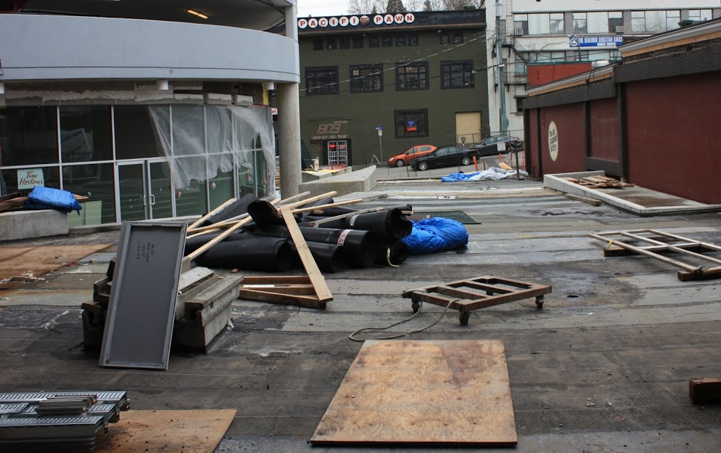
The bright side is the new Tim Hortons plaza exit heading north, although the compelling view of the back of the Spaghetti Factory and the front of a Pawn Shop won’t do much to improve the first impressions of people arriving in New West….

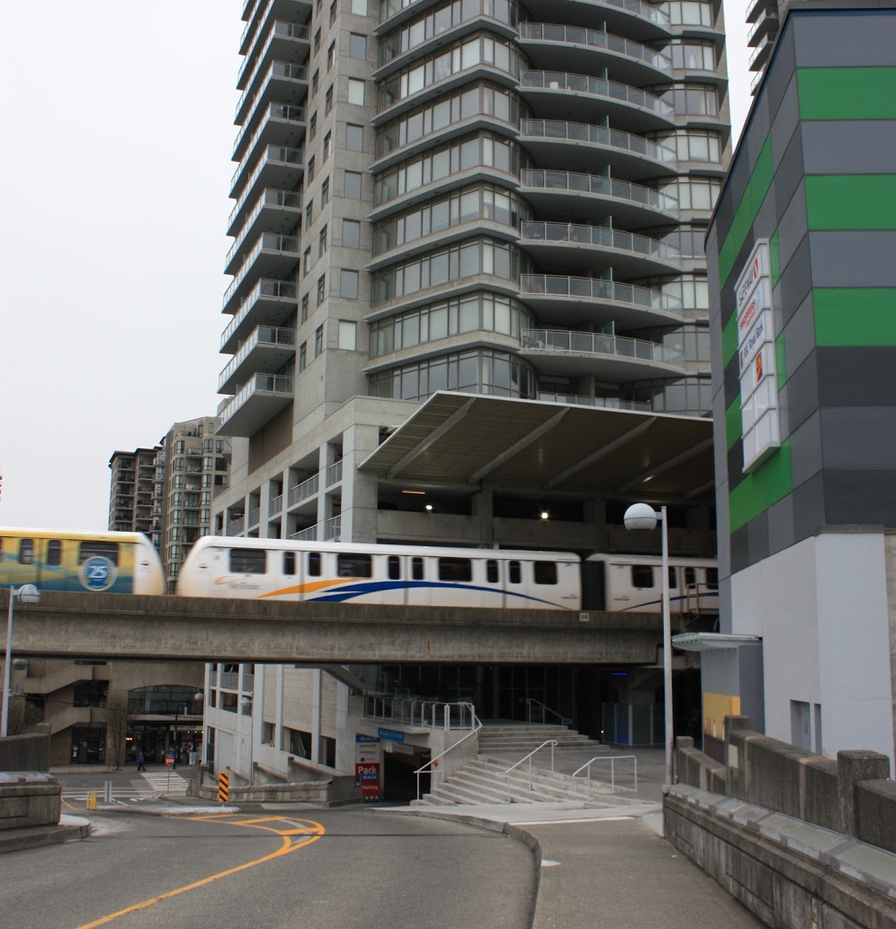
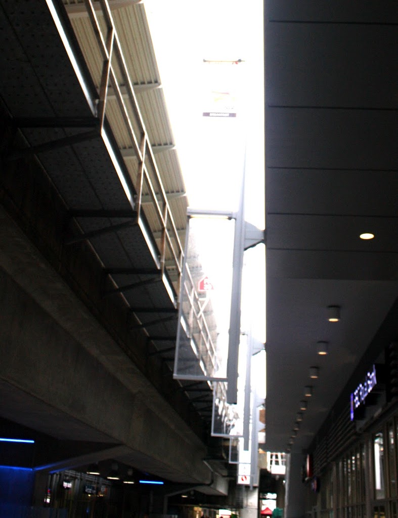
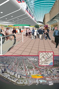
Back to the McInnes overpass, where you get to enter the Pedestrian mall right under the SkyTrain tracks, I have to admit the effect is very City of the Future when you watch the SkyTrain enter the building.

The first thing you notice is what appears to be some sort of stage or platform, right under the tracks. I imagine it is just there for architectural reasons, but I wonder what the intended use is. The roof clearance is less than two metres, so any musician would need to avoid Pete Townshend windmills or loose the skin off their knuckles. Restaurant seating would be interesting, although dinner conversation would be challenging with the roar of trains over head…

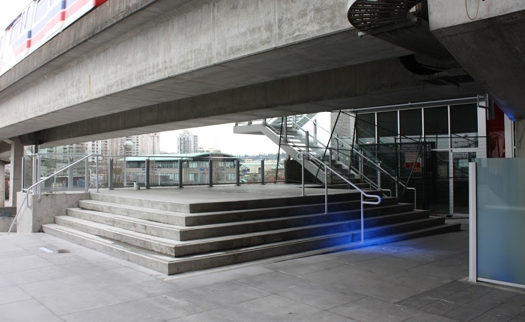
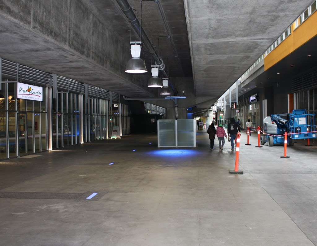
Once you enter the pedestrian mall, the space itself is pretty cool. The smooth concrete, pale tile and blue LED lighting effects have that retro-future industrial look. The roof is low and the bottom of the SkyTrain rails could use a power-washing, though.

In some spots, it is pretty clear that no-one at SkyTrain ever intended for people to be wandering around just under their rails. Anyone over 6 feet could easily reach into the cable trays hanging off the railbeds. The lack of “electricity can kill you!” signs suggests those are low-voltage or communications cables, but they add to a pretty gritty industrial feel, more so with the pigeon shit factor.

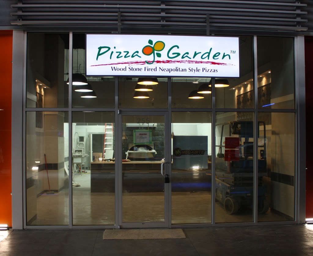
There are businesses slowly filling in. Some look pretty promising:
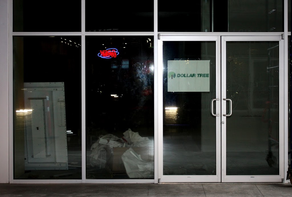
Others not so much.

It all seems pretty oriented towards service to local residents, as opposed to destination shopping. This is not MetroTown with rails through, it is a service centre at a Transit node. Banks, travel agents, dentists, and small restaurants and cafés: clearly targeting local residents and SkyTrain riders. I’m not sure of that will shift slightly when the upstairs level (with their multi-screen theatre) opens. Time will tell.

So far, the only space to sit in the pedestrian mall is outside the Starbucks attached to the Safeway. Here we see one of the strangest design choices:

I’m not sure what compelled Safeway to defend their little café sitting spot with 6-foot steel pillars and plexiglass. The unfortunate effect is to separate people at the café from the pedestrians, making both spaces less friendly, and making it way less likely I would sit in that glassed-in closet like area and have a coffee, watching the world walk by…

It is vaguely reminiscent of this caged-off area next to another City Square, both unfortunately less friendly becasue of their disconnectedness.

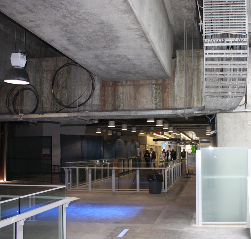
Not that many people will be sitting outside for too long in the lower level at Plaza 88. I hate to admit it, but the SkyTrain is freaking loud. There are places to the west of Safeway where the sound clearly echoes off the apron suspended over the rails, down through the gap between the upper concourse an the rails. I’m not sure of the vertical glass baffles in that gap help, or make the echo situation worse.

The gap also allows rain to sprinkle down over one enigmatically exposed 5-foot-wide strip adjacent to Safeway, when the rest of the mall is covered. I thought the original design was for it to be all covered. There was also suggestion that the SkyTrain rail bottoms would be more integrated into the design. Like or hate the look, it sure doesn’t look like what we were sold a few years ago:

One more aside. There was a bit of a local Twitterstorm this week around smoking in the Plaza 88 public mall spaces. A few local rabble-rousers (I may have been one of them) asked if the mall was going to be smoke-free, and to the credit of both TransLink and the City, there was some quick response to the Tweets: everyone is, apparently, looking into it. There is a system-wide ban on Smoking in Translink stations, but most of the pedestrian spaces are outside of that. Of course you can’t smoke indoors anywhere, but most of the pedestrian space is really outdoors, in an indoors kind of way. Its not like any outdoor plants would survive on the Safeway Level. You would be hard pressed to find any spot in the plaza that isn’t within 6 Metres of a door, so I guess that Provincial Law could be enforced, but by whom? (TransLink Cops? Mall Security? New West PD? Bylaw Officers?).

As this is a unique project and setting, I guess we can expect little teething problems like this to come along. I know from conversations I have had outside of New Westminster that this project was a difficult one to push along. There was a lot of work by the Mayor, Council, and City staff to make this project happen, between integration with a reluctant TransLink to various design components. At every step, it was pushing the limits of Urban Design in Greater Vancouver.

Am I fan? I don’t know. I hope I will be. Many of the design elements, from the tower facades, to the pedestrian challenges, to the head-scraping pigeon nests are kind of disappointing, but overall, I dig the Blade-Runneresque blue light retro-future look. I also think the risk will pay off if we manage to use the Kyoto block and integrate this project more effectively with the MUCF, Hyack Square, and the River Market. The commercial plaza wrapped around a SkyTrain Station is a brilliant idea, and there are lots of reasons to think it will be a model for development elsewhere along the SkyTrain system.

Now bring on the Theatres

On 6th Street, Drivers and crosswalks

I noted this story in the News Leader, and as sorry as I may feel for the “rattled molars” of drivers on 6th Street, the story seems to miss the bigger concern on that stretch by the Rivers Reach: the disappearance of the crosswalks.

I live about a block from here, and I’m not afraid to admit that I spend a disproportionate amount of my food budget at the Reach. During Hockey season, The iCandy and I spend enough time at the Rivers Reach that the wait staff know our order coming in. The recent change in hamburger bun suppliers at the Reach was a cause of lengthy conversation in our house. What I am trying to say is that we are regular customers. I also cross 6th on a regular basis, walking to the Curling Rink or Queens Park, or to the Uptown Market (a damn fine small grocery, if I may say so). This area is literally my back yard.

The sewer repairs and resultant asphalt cuts are a hassle, and presented some challenges to local businesses during the works, but with the average speed of drivers cruising down 6th somewhere around 80km/h, it has been kind of nice to have some speed bumps along the way.

What’s not nice are the crosswalks at Blackford (right in front of the Rivers Reach) and at 3rd Ave being essentially gone for 6 months. With several stages of pavement ripping having taken place, the road markings for the cross walk are essentially eroded away. Crossing 6th between the lights at 4th and the signalized crossing at Queens has become a harrowing experience, with pedestrians not sure of the drivers recognize that there used to be a crosswalk here (or if drivers notice the signs indicating there used to be a crosswalk here), and drivers confused by people stepping onto the road against the flow of traffic, with no crosswalk to be seen.

6th Street crossing at Blackford. Note great pub for scale.
The next block down, 3rd Ave. crossing of 6th. The signs belie the lack of road markings.

This is exacerbated by the works on 3rd Ave and 6th St., where the much-touted Discount Towers development (I think that was their name) has staged their construction equipment on the sidewalk with nary an accommodation for pedestrians, except a “sidewalk closed” sign. Causing pedestrians approaching form the west to cross 3rd somewhere (as there are actually no north-south crosswalk markings in the area) or to walk in the driving lane.

Makes me wonder why they don’t close the CAR lane, and re-route the crosswalk around the construction site using the freed-up car space? Crazy? Giving up a little car space instead of a little pedestrian space? Not crazy when you put it in context of the City’s Pedestrian Charter.

Which I reprint here for your reading pleasure (emphases thiers):

New Westminster Pedestrian Charter 

Walking is the universal mode of transportation; people around the world walk to work, school and other destinations. Nearly every personal trip involves some walking, often to connect with other modes of transportation, such as bicycle, public transit and private car.

A pedestrian is a person that moves from place to place, either by foot or by using an assistive mobility device.

To ensure walking is safe, comfortable and a convenient mode of travel, the City of New Westminster respects the following principles:

Accessibility
Walking is a universally available means of reaching and using goods, services, community amenities and public transit.

Equity
Walking is the most affordable mode of transport, and allows everyone of all ages and abilities including children, youth and seniors to travel independently.

Healthy
Walking is a proven method of enhancing personal health and well-being.

Sustainability
Walking relies on human power and has negligible natural environment impact.

Safety
Walking is a safe mode of transportation. The more people out on foot, the more a community has a greater sense of safety.

Community
Walking-friendly places are people-friendly places, creating a more livable and cohesive community and contributing to community vitality, both socially and economically.

To support and encourage walking, the City of New Westminster will:

  • review practices and regulations to ensure that a high priority is placed on pedestrian needs;
  • plan, design and develop a pedestrian-friendly environment in public space to meet travel needs of pedestrians;
  • improve pedestrian safety by minimizing potential conflicts between pedestrian and other users in the public right-of-way;
  • invest in pedestrian facilities and services to encourage people to walk for commuting to work and school, exercise and recreation;
  • integrate walking with other modes of transportation.

Actions:

  • provide and maintain infrastructure that gives pedestrians safe and convenient passage while walking and crossing streets;
  • provide appropriate pedestrian access to public transit services;
  • ensure weather protection is in place for pedestrians in commercial areas and other locations where there is significant pedestrian activity; and
  • seek funding opportunities with other levels of government and agencies;
  • ensure that all sidewalks in the City have appropriate curb cuts, that surface texture is constructed to prevent persons using mobility challenged devices from losing their grip on the devices, to include adequate lighting, and
  • access to buses be accommodated at bus stops for devices used by mobility challenged persons.

The City of New Westminster works with individual citizens, community groups and agencies, businesses and other levels of government to achieve a pedestrian-friendly, walkable community.

All I’m asking for is for someone in the City to open a bucket of paint and put temporary lines down until the road is properly restored. It is, quite literally, the very least we can do to live up to the Pedestrian Charter.

Trucks on Royal

This is an issue that bubbled a bit during the last election. Most notably, Council Candidate Vladimir Krasnogor raised the issue of heavy truck traffic on Royal Avenue throughout the campaign. The issue didn’t seem to have legs, though.

I used to live on Royal Ave and 10th: a great condo in a great building. Our first experience with Condo ownership was a surprising success, mostly because the Strata Council was proactive, with a few very sharp members who were able to manage the books and keep the ship running. The only downside of the place was intersection of Royal and 10th. The pavement was pretty beaten up, with a huge volume of heavy trucks causing the asphalt to ripple dramatically. Although the route is only a “daytime” truck route, it only takes a few scofflaw drivers to give people the impression it is a 24-hour truck route. Laden trucks grinding up Royal between 10th and 8th were bad enough, but the crash bang of (seemingly empty) container trucks rattling over the rippled pavement while racing through the intersection on the downhill route can shake you filings out, and that one-in-a-hundred jake-brake user during a quiet summer night paints all drivers with a bad brush, even from 20 stories up.

I sympathized with the folks at City Hall even when I was phoning to complain, yet again, about the guy in the Celeste green wood chip truck with the wailing brakes who drove down the hill, wailing away, yet again, at 5:00am. The City Bylaw Officers did what they could with enforcement, but it was an endless game of whack-a-mole.

What are you going to do? Trucks are necessary for the operation of our society. Royal is on the Major Road Network, and therefore Metro provides money to maintain it, and they are not likely to remove this route from the MRN unless viable alternatives are provided. I hear people at the Master Transportation Plan open houses talking about how “cut and cover” is the solution to all truck traffic issues, without acknowledging the costs and other logistical issues (not to mention the tradeoffs) that come with those types of hard, expensive, engineered solutions in urban areas.

This intractable issue has come up again, as part of the discussions around the Pattullo Bridge. Like many lightly-scabbed-over intractable problems, an off-hand comment from Matt Laird peeled it open again, and got me thinking about the problem in a different way. While looking at the various off-ramp designs TransLink had offered us for their new Bridge, Matt asked why trucks had to turn right onto Royal from the bridge. I’m not sure anyone in the room got what he was talking about, but for the last couple of weeks, that question has been stuck in my head like the baseline of “The Lion Sleeps Tonight”. There. Now it’s in your head too.

So I got thinking about the question, and came up with this handy little diagram.

This measures the distance between key points relating to truck movements around Royal Avenue. I’m assuming that the South Fraser Perimeter Road will be completed and the Pattullo Bridge (in whatever shape or format) will continue to connect to East Columbia and Royal near McBride. The numbers indicate the distances between the important node points. So the distance from 124th and King George in Surrey (the intersection of the SFPR and Highway 99A) to the north foot of the Queensborough Bridge via Royal is 1.6km + 4.5km, or 6.1km.

So let’s look at what options truck drivers have while crossing the Pattullo Bridge (for the time being, lets ignore the trucks that have specific business in New Westminster, and talk about the through-traffic only).

Arriving at the Hwy99A/SFPR intersection from any direction, any truck heading to the TriCities is pretty likely to take the Pattullo, as the asshats at MOTI have decided not to connect the two most expensive road-building projects in the Province (Port Mann 2 Hwy 1 and the SFPR) with an intersection where they cross. These trucks will therefore be forced to cross the Pattullo, take East Columbia, and get mired in the Brunette / Braid intersection and Brunette overpass hijinks. (note, the UBE would definitively NOT have solved this problem, as the trucks want to get to the 8-lane Lougheed or the 10-lane freeway, not to a driveway-laden 4-lane service road through big box retail and casino entertainment hell)

Trucks heading to the northwest will typically stay on 99A up McBride. The only trucks taking Royal would be those heading west to the Queensborough Bridge intersection: the aforementioned 6.1km trip. If their destination is along Marine to points west, the logical alternative is to continue up McBride to 10th, then go down Southridge Drive to Marine at Byrne Road: a trip of 10.6km, which is only slightly longer than the Royal route (which is 8.9 km total). If their destination is the East-West Connector, then their option is the SFPR – Alex Fraser route, which is 11.7km compared to 9.4km along Royal. Considering the SFPR route will all be separated freeway, and not involve stop-and-go traffic lights, even most destinations in Queensborough might be better serviced from the southern route.

Now what about trucks coming from the E-W Connector? The only reason for them to use the Pattullo is to access the TriCities if they choose the longer Alex Fraser – SFPR – Pattullo route, which is quite a bit longer (13.3km) than the Stewardson – Columbia route (7.8km), so not likely. More importantly, if their destination is south of the River, they might be best off to cross the Alex Fraser right away, as they will get to Surrey sooner (11.7km of freeway vs. 9.4km of City streets), so no Pattullo access needed at Royal.

Coming from Marine Drive, the only reason for trucks to use the Royal-Pattullo route is to get to Surrey, and Royal is only one of the three options (Royal is 8.9km, 10th and McBride is 10.6km, and Queesnborough is 17.7km).

So again, except for local traffic, why do trucks need to be able to access Royal from the new Pattullo? Is a 10% longer route along less-restricted roads faster than a shorter route with hills, stoplights and commuters?

I guess one point to take out of this is that we need to understand the ultimate routing of these trucks, in order to service them adequately, not just whether a truck is “local” or not. If only 5% of the trucks are using Royal Avenue because it is a significantly better routing than any alternative, but because of that 5%, we build Royal into the quickest route, then that will attract trucks off of the alternative routes that are only slightly longer. We also have to ask the hard question: is accommodating those 5% of trucks worth the cost to the livability of our City?

These questions require better data to answer. As does the “local truck question”: are there better alternatives to service the trucks whose destination is New Westminster, separate from the through-traffic? Remember, “truck routes” only apply to through traffic (trucks with local business are not limited to these routes, but can use service roads to access businesses that are not on truck routes).

Maybe Matt and Vladimir are right – maybe it is time to start talking about taking Royal off of the MRN. Could such a move be timed to coincide with the opening of the SFPR? Would such a move put the Pattullo replacement project into a new light?

Queens Park Master Planning

I love Queen’s Park. Not the neighbourhood I can’t afford (although that is very nice), but the Park itself. Sitting in the beer garden during Hyack, jogging the Centennial Trail during my occasional brief forays into fitness, walking though the hazy park after midnight on my way home from the Curling Club, even the occasional NWEP open-air meeting during the summer. Just looking at New Westminster from space (via Google), it is the square rectangle of green in the middle of Urbania that sets the geography of the City- even as it contrasts with the angry sharp finger of green that is Glenbrook Ravine.

It is the contrast with Glenbrook Ravine that speaks to the meaning of the word “Park”. The word is used to describe any generically green space in a urban environment, or otherwise protected space in other environments. There has always been a bit of dichotomy between park space being “preserved”, or set aside for nature, and park space being “programmed” for human appreciation of nature. Look at the protests about a rather innocuous walkway in Jasper, or the “No National Park” signs throughout the Similkameen Valley for examples of the conflict between how “Park Space” is valued or not by groups in our society.

Glenbrook Ravine is a pretty wild place, all trees and brush, a green sanctuary for flora and fauna (and overrun by invasive species), where few people wander off the one or two trails. In contrast, Queens Park has seen 125 years of poorly-planned development, the result a criss-cross of playing fields, paved and unpaved trails, parking lots and buildings. Even much of the Green Space is not actually plants, but painted plastic.

The City’s Parks and Recreation Department recognizes that much of the development of the park has been rather ad-hoc, with little long-term planning. So they are looking at changing that, and are launching a Queens Park Master Plan process, to make sure the park’s utilization is optimized in the future.

Much like the Master Transportation Plan, this process is going to take a few months and involve various steps and lots of public consultation. This first step for public input is this coming Saturday, with an “Ideas Event”.

Parks and Rec are encouraging everyone to come out an provide some ideas about the future of Queens Park – what do you like or not like about the current Park? What do you want osee happen to the park?

I have my own loves and hates with the park. I think the long-term preservation and management of the Really Big Trees is important for all sorts of reasons. I am less particular about the rest of the manicured gardens: I know the Rose Garden has a proud tradition, but I would love to see an area dedicated to the growing and preservation of important threatened species of native plants.

Upgrading the driving and parking areas to make them a little more, uh… “park like” would be a nice. Unfortunately, the area between the Stadium, the Arenex and the Arena is a pretty dismal asphalt jungle now, and that is (for many people) the first impression of the park that people get.

The Parks works areas are also a little disappointing in a setting as beautiful as Queens Park. The entire fenced-off maintenance areas both disrupt the park-like setting, and make wandering around the park less pleasant. I would add the petting zoo area to this list of strange disruptions. Again, I may be in the minority here, but I think the petting zoo concept is an idea well past it’s prime.

I like the idea of the Bandshell more than I like the actual Bandshell. Having enjoyed great concerts at the Malkin Bowl and Deer Lake Park, I can’t help but think we need a better outdoor venue in New West. Maybe the Bandshell just needs and upgrade, or maybe these types of events will move to the new Pier Park?

The picnic areas are so well used in the summer, that it is sometimes hard to find a spot unless you book well ahead. I think a few other less-structured sitting-and-meeting spaces could be integrated all around the Centennial Trail.

I think the Stadium is spectacular and under appreciated for its setting. I wish I had more reasons to go see Games at it (oohhh… imagine a Single-A baseball team?!? Line me up for season’s tickets!)

Ultimately, I don’t think Queens Park needs any radical changes, but subtle upgrades as the aging infrastructure is being replaced. As population density to the east of the park goes up, and property values to the west stay high, there will be more demand on Queens Park. At the same time, the new Pier Park may draw a lot of the picnic and other “programmed” uses away. Connecting the two via greenway trails, including the upgraded trails through Glenbrook Ravine, would make a nice connected green region of the City… but maybe I’m dreaming now.

All Pattullo, all the time.

I missed my first NWEP meeting in a couple of years to attend the TransLink Pattullo Bridge consultations in Surrey. I stepped back and did not take part in the “consultation” part (TransLink got a page full of notes from me at the New West meetings, let them hear from someone else for a change), I really just wanted to see how the other half lived, and get a sense of what the mood is on the Surrey side of the River.

Exposing my cultural biases, I walked into the meeting assuming that people in Surrey were all for the bridge, and the bigger and more toll-free, the better (which seems to be the position of their Mayor). Instead, I found there was a lot of diversity of opinion in the room. Admittedly, there was more discussion of getting rid of traffic lights in favour of onramps and overpasses in Surrey that I heard in any New Westminster meeting, but there were still a lot of people concerned about the need for the bridge, and the impacts on their community of yet another major highway expansion. Perhaps this should not be surprising, as these people are currently watching the installation of South Fraser Perimeter Road in their neighbourhood – highway expansion is not a hypothetical to them.

One of the issues I heard a lot of (that was new to me) was the encroachment of industrial and commercial development in the Bridgeview Neighbourhood. There are a lot if single-family homes in the area between King George Highway and the new South Fraser Perimeter Road, and the residents are feeling squeezed by the commercial properties along King George, the industrial lands to the east and west, and the new truck route to the north. One resident of 124th was concerned that the proposed expansion of 124th to accommodate truck traffic linking the SFPR to King George was going to bring trucks through the middle of this neighbourhood, and within 20 feet of his house. His house is built on “60 feet of peat bog”, and every time a truck drives by now “I get shaken from one side of the sofa to the other”.  Naturally, goods movement through his front yard does not seem like a good idea to him.

For many Bridgeview residents, the “Upstream” vs. “Downstream” question, which I kind of made fun of for the New Westminster side as an example of a completely irrelevant question, is not at all irrelevant. Downstream means the bridge will extend over a small area of waterfront park space (a limited, and therefore valuable, commodity in Bridgeview), but the Upstream option will move the elevated parts of the bridge closer to their homes, potentially increasing noise and view impacts.

Another thing I learned is that TransLink is actually listening. Many of the issues raised by residents in the first consultation in New Westminster two weeks ago are now being brought up by TransLink during the introductory discussions. This has even resulted in more complete answers being provided to address some of the uncertainties I raised in my earlier posts about this project.

And example is more detailed explanation of the 6-lane bridge decision. Frankly, I still think the “increased safety” argument is a red herring, but the argument for 6-lanes is more fleshed out now with discussion of the business case made back in 2008, and subsequent reviews of the business case. It would be great if the metrics of those analyses were available on the consultation page. Especially as I heard one interesting discussion at this event about how the value of the existing bridge was assessed.

I had something like this question bouncing in my head recently, but I didn’t know how to frame it. Luckily, one of the participants in Surrey was very eloquent on the idea (more than I will be in this paragraph): what about the social and economic value of the existing bridge? Like it or not, the Pattullo is an iconic structure, a steel arch-span bridge similar in age, height and length to the Sydney Harbour Bridge (though less than half as wide). It’s arch has loomed over New Westminster for 75 years: the same age as the Lions Gate Bridge and the Columbia Theatre – two structures of which no-one would argue the heritage value. Surely this has a socio-economic value to the City, and to the region. If Translink wants to replace it with another dull, cookie-cutter, concrete cable-stayed bridge built by the lowest bidder, what value is lost? Honestly, I don’t know how we estimate that value (or if we can), but this is a question that a City that prides itself on its Heritage Values needs to address: What will New Westminster look like without the Pattullo?
?

Thank You Jack Campbell!

? Another interesting question was raised by one of the participants at the tables rising from the data provided by TransLink. If the daily truck volume is 3,000 and the daily vehicle volume is 60,000, then less than 5% of the volume is actually trucks. 20 cars per truck. So why are we building a 24-hour dedicated truck lane each way? How much do we anticipate truck volumes growing? 3,000 a day is only 1 or 2 each way per minute. This seems like a lot of extra money for very few trucks. Or more frightening, does TransLink think the increase in trucks will be much, much larger? What impact will this have on New Wesmtinster?

Maybe I am getting mired in the details too much, and am missing the fundamental point here; and if so, perhaps TransLink is doing the same thing.

At all of these consultations, I have had friendly chats with TransLink Roads and PR staff, the consultation team from HB Lanarc Golder, and the representatives from the engineering firm that provided the conceptual design work. All of them say the same thing: we need to build a bigger bridge because traffic volumes are going up. Some people in the room disagree with this (as do, apparently, some members of New Westminster Council). So perhaps TransLink should not have sent their roads guys to come and consult with the City of New West on the topic of offramp shapes, but should have sent the Policy Guys to come and discuss the need for a bridge.

Perhaps the fundamental question we need answered is this: What is Translink’s Mandate? Is it to create the transportation system that people want, or that Kevin Falcon wants? Or is it to set transportation policy for the region? I always thought the latter, but the Act seems to suggest they carry both responsibilities. If so,  shouldn’t the Policy part come before the building part?

TransLink’s policy document right now is Transport 2040. So before they send people to New Wesmtinster and Surrey to talk about offramps, they should come to our communities and have a discussion about how Transport 2040 fits our local conditions. Then we can talk about the type of bridge to build. As it is, building an expanded road bridge while Surrey and the Broadway Corridor wait for their long-promised mass transit investments seems to be a demonstration of a policy very diffrent than laid out in Transport 2040. 

Pattullo Bridge Consultation – Day 1

First off, you think TransLink would learn their lesson.

During their last foray to New Westminster to consult on highway expansion, the turnout was at first completely overwhelming, then Standing Room Only in the subsequent hastily-assembled  4- or 5-step consultation proccess. This month’s public open houses for the City’s Master Transportation Plan had a higher turnout than the consultants have ever seen at a similar event, more than 100 people each for the first phases of what, for most sities, is a dull planning document. The Lesson? Have a public meeting about Transportation issues in New Westminster, and people are going to show up! There is no excuse for having too small a room and not enough chairs for the participants.

I’m not going to talk too much about what Translink discussed at the Workshop at Centennial Centre on Tuesday. Daniel at City Caucus sums up the spirit of the room pretty well, and we were not really offered any info that isn’t available on the TransLink website for the consultation.

Instead I am going to talk about what wasn’t discussed at the meeting, and why that is a problem.

The first topic that was not up for discussion was the number of lanes. TransLink has determined they will build a 6-lane bridge with two of the lanes (apparently) dedicated to trucks only. No business case is made for this (for perspective, a transportation expert once opined to the NWEP Transportation Group that the difference between a 4-lane and 6-lane bridge could be as much as $300 Million). When pressed on the question of lane count, TransLink suggested 6 lanes was the only option on the table for “safety reasons”. The somewhat convoluted justification being that keeping trucks on the outside lanes keeps them from needing to change lanes on the bridge, or mix with the cars on the inside lanes, increasing safety for all users. That sounds good, unless you are paying attention. Take a look:

click to embigginate

All of the designs deal with on ramps the same way, but I’ll use this one as an example, because it is first alphabetically.

Say you are Dave the Truckdriver entering New Westminster from Surrey, over there in the rightmost lane. If you want to go east to Highway 1, you take the first offramp, if you want to go towards the Queensborough, you take the second offramp, if you want to continue north towards Burnaby, you stay on the main route to McBride. All are options, as all are on the Major Road Network and designated as Truck Routes. It is unclear where the main route changes from three to two lanes, but it is presumably at the first or the second offramp. If it is the first, then you will need to change lanes before then (unless that is your destination). If it is at the second, you will still need to change lanes before that. Trucks going North will always need to change lanes. So lane changing is inevitable unless all trucks are forced to a single offramp going in one direction, but that would significantly reduce the usefulness of the bridge for “Goods Movement”, wouldn’t it.

The same situation happens for trucks heading south down McBride onto the bridge, or entering the on-ramps from the other roads, they are either going to have to change lanes to get to the outside lane, or merge onto the outside lane, and there will be inevitable mixing with cars. Oh, and cars using any of the offramps will of course need to move into the lane with the trucks in it, presuming the exit ramps are all on the outside lane. It is inevitable that cars and trucks will need to move lanes, and will need to at some point share lanes. Mixing of cars and trucks in inevitable.

This is the important part: These inevitabilities do not change at all between a 6-lane or 4- lane structure. The argument that a 6-lane bridge is “safer” is a complete wash.

The second point that was not discussed was the bigger picture around how we will manage the extra traffic once it exits the off-ramps of the bridge. TransLink pointed out one of the arguments against locating the bridge in another location (such as upstream at Sapperton Bar, downstream at the Tree Island location) was the integration with the existing road network. However, the current road network on the New West side is built to accommodate a 4-lane bridge, and already fails at times to accommodate that traffic load. Increasing the bridge by two more lanes will increase traffic capacity at the City boundary by 50%,. Currently, there is no plan to accommodate that. Think McBride is backed up northbound now? Think Brunette and Braid is an issue today? Think the Stewardson-to- Queensborough connection is a mess today? How will increasing traffic 50% to these locations help?  This is unfortunately and eerily like the UBE discussion again.

Tranklink responded to this saying: we’ll design the bridge first, then figure that out. Not surprisingly, few people in the room were satisfied with that answer. That answer shouldn’t be acceptable to anyone in the region who is funding TransLink; even those that believe building roads can solve traffic problems. TransLink wants to spend a Billion of your dollars to move a traffic pinch point 100m up the road. This is an example of a build-then-plan mentality that has them currently building a $4 Billion 10-lane Port Mann Bridge / Highway 1 Widening Project and a $1 Billion South Fraser Perimeter Road project, two major new Goods Movement routes that actually cross each other but do not intersect, forcing trucks to drive through New Westminster to get between them.

Oh, and that Billion dollars? That was the third topic not discussed. According to Translink, there is currently no funding source for the bridge. They are therefore presuming that it will be funded by tolls, likely through a design-build-operate concessionaire, much like the other 16 lanes of Fraser River crossing traffic that have been built in the last decade. They won’t say it is tolled, but they won’t say if there are any other sources.

This creates another area of uncertainty that needs to be addressed before we go any further. The BC Liberals have, as few as two weeks ago in that strange radio-interview-mini-throne-speech-event, suggested they are against tolling. The Mayor of Surrey doesn’t like tolls for this bridge. However, the senior governments are not lining up to dump a billion dollars on TransLink, and TransLink can’t raise taxes. So how are we paying for this thing? TransLink says let’s design it, and get approvals, and the money will arrive. One significant problem with this, of course, is that we cannot establish the business case or the demand for the bridge without knowing if it will be tolled.

TransLink representatives after the meeting admitted their estimates for future traffic demand on the bridge are based on tolls being collected. They provided some demand estimates based on population growth: increased vehicles from 60,300 today to 94,800 in 2041, but didn’t make clear in the presentation part that these estimates are based on a 6-lane, tolled bridge. How do these estimates change if we build a 4-lane bridge? Or if we don’t toll? Or if this same $1 Billion is invested in rails and/or SkyTrain for Surrey and Langley? Or are we, once again, just going to build it, then plan?

We have learned from the Golden Ears bridge example that tolls are effective Transportation Demand Management tools. People have avoided paying them, by driving around the long way or by reducing the number of trips. We have also learned from the Golden Ears that traffic estimates for tolled bridges can be overly optimistic (not the same story for new rapid transit infrastructure).

So without demonstrating the need for increased lanes, without explaining how these increased lanes will be accommodated on our already crowded and built-out streets, and without telling us how the bridge will be paid for, TransLink has taken to time to ask us which side of the old bridge we would prefer the new ramps?

Sorry TransLink. For some reason, the people of New Westminster are not feeling like they are “Part of the Plan”.

Cluffy and the Bridge

It is not going to surprise any CBC Radio1 listener if I admit to being a firm Anti-Cluff-ite.

Rick Cluff is the morning show host in Vancouver on the Flagship Mothership, and comes to us after a long history of sportscasting in southern Ontario. This explains why the only thing he approaches with any intelligence or enthusiasm is sports. When talking to the Sports Guy in Toronto (whoever that is this week), he is in his element. And food; he seems to really be into talking about food. For pretty much any other topic, he is hopeless.

It is worst when he is interviewing someone on a topic he is less versed in, like, say, this morning’s interview with TransLink’s Sany Zein about the Pattullo Bridge. (you will be able to hear it here, February 21, just before the 8:00 news, so about 1:50 into the 2:35 program). Rick’s technique is to prepare for the interview by finding the conflict, then writing down a bunch of questions probing that conflict. That way, during the interview, he can read the questions off the page (and the cadence he uses make it clear he is reading through the bottom of his bifocals) and not have to worry about listening to or understanding the answers. It is especially funny when an interviewee provides the answer to the question before Rick asks it, and Rick just can’t break the script and have a conversation, so he boldly charges ahead and asks the question just answered…

In this morning’s conversation , the conflict narrative was New Westminster being a roadblock to replacing the aged Pattullo. Sany Zein tried to clarify and explain that New Westminster was in the middle of their Master Transportation Plan and that the two consultations would work in parallel, and together. There is no conflict there. Then he has a canned input from Wayne Wright saying the same thing, followed by Mr. Zein repeating it, but Rick kept on narrative- How can they move forward with New Westminster being so uncooperative? It was painful.

The worst part is that Rick’s blind devotion to the conflict he wrote down on his crib sheet kept him from asking questions most of his listeners wanted to have answered. How big will this bridge be? Who is going to pay for it? Will it be tolled? How can the public get involved in the consultations? You know, useful information that the news could provide, instead of trying to find a simple conflict narrative to attach sports metaphors to.

Contrast this to Stephen Quinn’s interview approach, where he carries on a conversation, responds to the previous answer, and prepares himself ahead of time so that he can follow the conversation wherever it leads. He also has a knack for fitting in that one slightly uncomfortable question that the public wants to hear answered. Quinn is clearly the best interview talent on the local CBC. Yet again, I digress.

In the case of this morning’s interview, Rick Cluff continues his trend of seeing the world through a windshield. He is of the generation that thinks you can solve traffic problems by putting more roads down, which is a frankly ridiculous approach in the year 2012. This might be because he drives in from White Rock at 4:30 am when the roads are empty, then listens to the traffic reports all day and can’t imagine the cars are the problem.

Regardless, Sany Zein is, in my experience, an approachable and thoughtful guy. So you should feel comfortable asking him questions directly during the open houses coming up this week. Starting tonight!

MTP Open House 1.20

If you missed the first open house for the Master Transportation Plan, or would like to arm yourself before the St. Valentines Day Messaging, the presentation materials are available on-line at the City Web Site, which provides me the opportunity to go on about some of the details therein. I am completely copying these graphics here without permission form the City, so I suggest only New Wesmtinster taxpayers, who paid for them, should click on them to see full-size versions.

The fifth slide (above) provides the first really interesting data. The bar chart shows Metro Vancouver municipalities ranked by “mode share”. That is the proportion of “trips” taken by modes of transportation other than driving a car. It is pretty clear from this bar chart that New Westminster is already a regional leader in sustainable transportation, with a mode share of 36%, second only to those dirty bike-lane hugging hippies in the City of Vancouver.

What I take out of that chart, though, is a demonstration that infrastructure matters. The top three Cities are those with the complete integration of the SkyTrain. The next two are also well serviced with transit, with the SeaBus an important part of their infrastructure. All of the top 5 have put serious investment into bike lanes and pedestrian amenities. They have all put an emphasis on building compact transit and pedestrian friendly town centers.

Now scan down to the bottom of that list, and see lowly old Langley City. Aside from its abysmal transportation infrastructure and complete commitment to automobiles, Langley City has no excuse for this. It is compact with relatively high population density (2,500 per sq. km., compared to New Westminster’s 3,700 and Burnaby’s 2,200, which are all way higher than North Vancouver District or Langley Township, which are both under 500).  It is relatively flat with a good balance of industrial, commercial and residential land. This 9% is no surprise, however, to anyone who has tried to traverse Langley City. No cycling facilities at all, disconnected and disregarded sidewalks, a half mile of parking lots separating every business. About the only infrastructure it has is a Bypass Highway and the Big Box Hell that is 200th Street. As a cycling buddy of mine once said, reading a road sign: “Langley Bypass. I don’t care where you are going, that sounds like the right idea.”

What’s worse: the Mayor of Langley City, Peter Fassbender, is the vice-chair of TansLink’s Mayors Council. I’m not sure if the 9% should be more embarrassing for him, or if TransLink should be more embarrassed that he has been elevated to help lead the region in Transportation when his own City serves as cautionary example for the whole region… but as usual, I digress.

The walking numbers are not surprising. New Westminster is a great City for walking, and the hills are less of a barrier than some people (Such as the Downtown BIA) suggest, as long as the sidewalk infrastructure is there to make the walking environment pleasant. The map shows that Connaught Heights and Queensborough lag behind as far as walking infrastructure go. The “missing link” between Point Royal and The Quayside really stands out though…

The bicycling infrastructure info is actually a little disappointing. The cycling mode numbers are lower than I would expect, and the cycling network is distressingly incomplete, 13 years after the cycling plan for the City was laid out. Even the designated bike routes we have are either suffering from erosion from disregard (BC Parkway anyone?), or are bike routes in name only, being just as unfriendly for cyclists and completely unmarked as they were 20 years ago (try to cross 20th street on the London Bikeway, I dare you).

I love the topography map they have on the 10th slide. Whoever thought of that map must be a genius. It shows that most of New Westminster is not really that hilly. There are only a few areas where the slopes cause a real challenge to recreational or casual cyclists – the Downtown-Uptown link, the Brow of the Hill, and Sapperton. I hope with this Master Transportation Plan, we can re-draw the cycling map with this in mind, and find creative routes to make these slopes manageable for more cyclists. The City’s Bicycle and Pedestrian Advisory Committee already identified a route from New Westminster Station to the Saint Mary’s site that connects relatively gentle slopes with very short stretches of higher grades, with only a few missing links that need to be connected. The advantage of the current low mode share is that it should be easy to increase in the foreseeable future.

Transit is a good news story for New Westminster, and a large reason why we have such impressive mode share numbers. As I said before: infrastructure matters. Five SkyTrain stations for 60,000 people is one of the remarkable advantages of being a compact City in the centre of Metro Vancouver.

The problem comes down to frequency. The diagram above shows AM peak time frequency, which is pretty good. However, the City’s largest employers are not 9-to-5 mom-and-pop operations, but have a lot of shift workers. We also have a large lower-income population (due in part to our large rental property stock) who tend to also work in less traditional jobs. The reality for many people in New Westminster is that much travel for work is during off-peak times, not to mention travel for play. When transit service drops to 30-minute, or 60-minute service, it becomes completely unreliable. Especially in a place like Queensborough, where 20 minute bus service for a 15-minute ride to 22nd Street mean that it can take more than half hour at the best of times just to get to the SkyTrain Station you can see over there on the Hill. Once we hit 11:00pm, much of the transit frequency drops to zero.

Of course, this is slightly out of the scope of the City’s jurisdiction. there is little the City can do but lobby TransLink to improve service. Unfortunately, we have been going the other way of late. What the City can do, however, is make sure the infrastructure on the ground is there to make using transit easier. For example, the City, as a general rule, lacks bus shelters. There are also several decisions we can make to prioritize cycling and pedestrian infrastructure improvements at vital transit links. Finally, we can (outside of the Master Transportation Plan, mind you), continue to encourage dense land use at our major transit nodes, like we have done at New Westminster Station and Sapperton Station, and are looking at for Braid Station. How long can 22nd Station be surrounded by single-family homes?

Slide 16 was interesting for a few reasons. The numbers that really stood out for me were 4,300 vehicles per hour on the 4-lane Pattullo Bridge compared to 3,500 on the 4-lane Queensborough. Who would have thought the lil’ old Queensborough carried more than 80% of the traffic of the big bad Pattullo? But I also don’t understand how we can have 3,000 vehicles on both sides of the bridge, and 3,500 over it… there is something funny about where these numbers were collected and what they mean for that intersection. I suspect this also argues pretty strongly towards saving a ton of money and and replacing the Pattullo with a 4-lane structure, but another post, another time.

It was also interesting to see how the intersections we all love to have performed when measured by actual delay relative to their design traffic volume. The stand-out is that the intersections on 20th perform fine. This is a surprise to those backed up on 20th, or the people of Connaught Heights and the West End who can’t get out of their neighborhoods due to the gridlock on 20th. this also reflects a recent traffic study on 20th done for the City by another consultant. Long and short: the problem is the Queensborough Bridge. There is nothing we can do to improve 20th street except re-write the Queensborough Bridge interchange, which is Provincial jurisdiction and has already had a large pile of cash concerted to concrete in recent years. I think the best approach here is to re-design the traffic system on 20th to make it most useable by Connaught Heights and West End Residents, and let the through-traffic back up into Burnaby. It may be a simple as redesigning the traffic light signals…

The good movement info here is the one that has so far generated he most discussion. The City’s survey has reflected what TransLink has said all along: about 40% of New Westminster Truck traffic either starts or stops its trip in New Westminster. A few people (including Councillor Chuck Puckmayr at last week’s Committee of the Whole meeting), have questioned the methodology that resulting in the is number. I am more interested in where in the City these stops are happening – are they all going to Kruger? Are they driving across the Pattullo and through downtown on the way to Queensborough landing? Just how many semi-trailers full of food does Safeway need in a week? I really don’t know. But that kind of data might be useful.

The other part of the goods movement discussion is already popping up in the local media, and that is the future of truck traffic on Royal Ave. I think the issue of directing all commercial traffic to Royal is a big one, especially as we are going to have another school built right on it. There is strong pressure right now to make Royal the truck route, which will effectively increase total truck flow through the City. I think that is a bad idea, for various reasons. But again, this is already too long a post, so I will address that another time.