Discussing the Parkade- Part 1.

There was a meeting tonight hosted by the Downtown New Westminster Business Improvement Association, on the topic of… well… a few things.

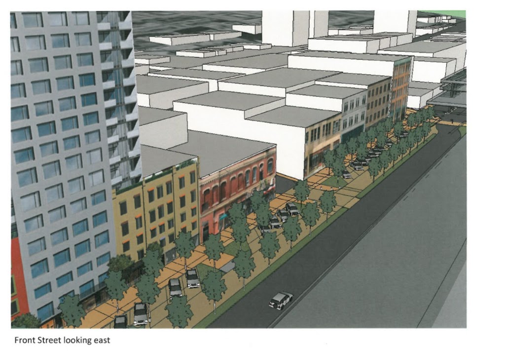
The main point of discussion was the future of the Front Street Parkade. There have been reports to council talking about longer-term visions for the waterfront, most of which include the partial or complete removal of the Parkade. These are supported by some engineering reports that indicate the maintenance costs for the Parkade are likely to go up significantly in the next few years, and some decisions are going to need to be made about how much to invest. It probably doesn’t help that some uppity bloggers have been calling for the end of the Parkade for a while now…

Naturally, there is a significant number of downtown business owners who see ample, inexpensive parking as fundamental to their business success. When others (be they uppity bloggers, City Staff, or Elected types) start talking about taking away their parking, they get a little itchy.

The BIA also had some gripes about back-in angle parking on Columbia, Bike Lanes, bike lanes, and Pay Parking on Sundays, but those issues seemed to be brushed aside as the conversation centered on the past, present and future of the Parkade.

Present were about a score BIA members, and about the same number of non-BIA types (including downtown residents and uppity bloggers), a few members of the local media, and from the City: Mayor Wright, Councillors Puchmayr, Harper, and MacIntosh, and Jim Lowrie from the City Engineering Department.

The Transportation Committee of the BIA provided a PowerPoint presentation with a lot of words on it (all caps lock), and perhaps I will go through that presentation in detail in a later blog post. Now I want to more talk about the spirit of the room and the nature of the conflict, from an uppity blogger point of view.

If I’m not sure how to summarize what the BIA’s complaints are, it might be because they have not come up with a coherent message. It is clear they do not like that others are suggesting they are going to take away parking. They feel that access to parking, and more specifically, access to the entire Parkade that they (or their ancestral business owners) financed and built, is not only necessary for their businesses, but is vital to the future of the City’s business community.

Arguments that the Parkade is underutilized are countered by the BIA suggesting the Parkade is too expensive and not effectively marketed. Dan O’Hearn from the BIA went so far as to suggest that if the Parkade was put under the control of the Downtown Merchants, it would be filled to capacity providing revenue for the Merchants. This reflected a certain spirit in the room that the Parkade is just poorly managed by the City.

To me, this argument has always sounded like cognitive dissonance, to argue on one hand that every parking spot is needed and that Downtown suffers from a lack of parking, then to argue on the other that the Parkade needs to be more effectively marketed to get people to use it. Are they saying there isn’t a lack of parking Downtown, there is a perceived lack of parking? Or are they saying there are simply not enough parkers downtown? How is either an argument for investing in a mostly-empty Parkade?

Even then, whose responsibility is it to advertise the availability of parking in the Downtown Parkade? The City? The Parking Commission? Dare I say, the BIA?

However, I think the main complaint I heard was that the BIA was not in the loop about what is going on. I heard a lot of people unhappy about not being consulted, and more than a few people worried that the Parkade would be going away this year, with no plan to accommodate the people who currently use the Parkade. It may only be 30% used on most days, but that still represents more than 200 parking spots.

I think this is where there is agreement between the BIA and uppity bloggers like me (and other people who are looking forward to a pedestrian-friendly Front Street connecting Downtown with real human ties to the Waterfront). We agree that there needs to be a plan. I just happen to think we need to look at confirming our current and future parking needs, then planning to accommodate those needs as we develop the Downtown, with the eventual goal being the removal of the eyesore Parkade from our waterfront. The BIA just doesn’t want the Parkade removed until there is a plan in place to accommodate Downtown parking needs. Some might think we are looking for the same thing.

Jim Lowrie and the Councillors at the meeting said as much. The plans they have read regarding eventual Parkade removal have been mid- to long-term planning documents. The City has no intention of removing the Parkade until the BIA and other stakeholders have been consulted, and until there is a comprehensive plan to address the current and future parking needs of Downtown.

So the two sides are not too far apart, and the City is right in the middle. This shouldn’t be to hard, should it?

The Port Declares War

Jeff Nagel of Black Press (who is turning out to be the best Municipal Affairs reporter in the local Dead Tree Press) wrote a piece on recent proclamations by the new CEO of Port Metro Vancouver, and the reactions from various groups throughout the lower mainland.

My first reaction was – poor bastard from England has no idea what he is doing wading into ALR politics. Then I did a little research and see that CEO Robin Sylvester was party to the sell-off of part of BC Rail, so he is obviously aware of (and not afraid of) the worst of BC political morass. He knows exactly what he is wading into here, the poor bastard.

My issue with the Port Authoirty is not just their stunning disregard for the spirit of the Agricultural Land Reserve (even if, as a Federal Agency, it doesn’t apply to them), but their business model. It isn’t just farmland that the Port has declared war upon, it is our roads, our waterfronts, and the livability of our cities.

All of this discussion skips over the reason we have n ALR. It is because BC has very little high-quality farmable land, and most of it is very close toVancouver. Once farm land becomes industrial land, commercial land, or a neighbourhood, it is neigh impossible for it ever to be returned to agricutural use. none of these characterisitcs are true for Industrial Land. Industrial Land can be located anywhere, and land that was once industrial can be easily converted to other uses – and land under other use can easily be converted to industrial use. All it takes is for someone to spend the neccessary money to convert the land. So the need for an “Industrial Land Reserve” is a red herring. There is no scarcity of land to put warehouses upon, although there is currently a scarcity of people willing to spend money to deveop industrial land, and a lack of willingness for Cities to provide appropriate industrial zoning within their land base.
Which brings us to the Port, an organization that is exploting these issues, and is rapidly getting out of the business of taking things off of and putting things on to boats. If farmland (which is commonly located right next to the River) is sacrificed for that, they may have an argument for balancing out industry and farming. Frankly, if the current buzz-word “Food Security” is our primary concern, it is no worse than Golf Courses or cranberry bogs, or even the 100-acre greenhouses being built on ALR farmland today:

140 Acres of our best Reserved Agricutural Land in Delta

Except that the port isn’t using our prime farm land to take things on and off of boats. They are using it to take things on and off of trucks, something they can do on any land, really. No need to use ALR land. The only reason they choose to do this on ALR land is because they can buy ALR land at a fraction of the cost of non-ALR land. Since they are able to remove it from the ALR with federal fiat, they can convert it to valuable lease space for warehouses, instead of buying expensive commercial- or industrial-zoned land that municipalities have set aside for just that purpose.

This is because the Port is no longer in the business of taking things on and off of boats, they are now a real estate development and lease business. How else can one justify the purchase of more farm land in Richmond? Look at the port land adjacent to their recent purchase in Richmond:

click to zoom it. or go to Google Earth yourself

All those warehouses (actually there are more now, this photo is a little old), a new highway overpass to connect this land to the East-West Connector, and only one thing is missing: Docks. There is a single berth there for ships, where a single business moves wood pulp onto barges from the rails. Every other business there is truck-oriented, with only a couple even having rail spurs. This is the Port Authority business plan for ALR land. Buy cheap, develop, lease for cheaper than anyone else can. That’s the free market, I guess.

So what? Notice how much of the talk about the traffic issues in New Westminster are around “goods movement”. The issue always comes up of trucks crowding our roads, or our livability being eroded by the noise and pollution of all this container traffic on our roads. When people wonder why we aren’t using the river or the rails more, why there are all these trucks on the road. They aren’t bringing laves of bread to Safeway, they are shuffling goods from the actual Port to “Port Facilities” like these, and to the vast warehouse ghettos of places like Port Mann, Port Kells, and Port Coquitlam – all locations of huge truck warehouses, and all lacking in actual Port facilities to move things on an off of boats (with the occasional exception of logs and woodchips).

How will we ever make use of the goods movement opportunities of the River, when it is against the business interests of the Port Authority – the only agency with any jurisdiction over the waterfront?

Master Transportation Plan Open House 1

Yesterday was the first Open house for the City’s new Master Transportation Plan process. Right off the bat, it looked like the turnout was great. I would put the over/under on total attendance at 90, if you include the staff and a few City Councilors (but, notably, not the Mayor). It was no donnybrook, but for a preliminary information session held on a busy night, it was good to see so many people are interested in the process. 

The Open house featured poster boards with some of the preliminary info collected by traffic counts and surveys, and a short presentation providing details on some of the posters, and giving a broader view of the process ahead. There were also some opportunities to add your comments to post-it boards, and to fill out a survey of pretty general questions. I have a few comments on a few interesting facts and ideas provided by the posters and presentation, but I’ll cover those in a later post. Here, I want to talk more about the feeling in the room. 

From listening to the conversations, most vocal concerns could be summarized into one of three broad categories: 

1) Through-traffic is a problem, but we can fix it once and for all by doing “x”; 

2) The intersection of “x” and “x” is the worst in the City! It needs to be fixed; and 

3) Why aren’t more tickets given out to bad drivers / cyclists/ rat runners/ anyone but me? 

Of these, number 3 has the least to do with the Master Transportation Plan. It speaks somewhat to a poorly functioning transportation system if systemic lawbreaking is the normalized way to operate the infrastructure, but targeted enforcement is really a complex issue involving driver education, signage, the police, and the community. The Master Transportation Plan will hopefully result in a better-integrated system that reduces the bad behavior of users, but that is rather secondary to where we are here. If traffic enforcement is really a passion of yours, why no join the City’s Neighbourhood Traffic Advisory Committee… they always need help! 

Number 2 is sort of what this is about. The solutions found might pick out a few key intersections and areas for improvement of the transportation network, but the bigger ideas will come in answering questions about how we want our intersections and other infrastructure to work, and how the various bits of the infrastructure can work better together. 

Number 1 is a big part of this. However, I bet the problems are more complex that we think, and that the solutions will not be simple ones. Unfortunately, some of the problems will not have a satisfying solution at all (Queensborough Bridge, anyone?), but that doesn’t mean this process is not useful or cannot change the way we approach these problematic areas. 

After the presentation, there was a bit of time for a few questions from the audience, the answers to which I can paraphrase here (yes, both the questions and answers below are paraphrased, any error of fact or language is mine, I tried to catch the gist of the conversation, if not the detail). I have added my comments after each Q&A point. 

Q: You say 40% of trucks are going to a destination within the City, but what about the rest of the traffic? It would be interesting to see how much of the car traffic passes right through.

A: No answer was offered, as it seemed like more of a statement than a question. 

This, more than any other point, is the big gripe New Westminster has about traffic, and the gripe our neighbouring communities have about us. I concur that it is important for us to get this number, because it seems to range depending on whom you ask: 60%? 80%? More? And so much of the conversation in New West is about it, we should start from a factual base. The strange part in this discussion is that many people who think this is our #1 problem also think the solution to too much through-traffic is to blow the bank on building infrastructure to accommodate more through-traffic (freeways through, around, or under the City). 

Q: How does this align with the proposed Pattullo Bridge project?

A: The Pattullo Bridge project is the jurisdiction of TransLink, and will include its own public consultation process, likely starting as soon a February 

However, the data collected for this plan, the impacts of the Pattullo refit/replacement, and the impacts on New Westminster when the Port Mann II comes on-line with its tolls, will all need to be considered as part of the City’s planning. I didn’t get confirmation on this, but I assume TransLink will be one of the agencies identified as a key stakeholder in the entire MTP process.

Q: This City is right next to the River- is there any consideration to using the River for transportation?

A:We don’t know of any plans to move passengers on the river that have gone past the very-high-level concept phase, but there has been discussion of this in the past. Port Metro Vancouver will be one of the Agencies invited to take part, and they have been invited to have a seat at the table here

Goods movement on the River has been a pet peeve of mine for a while, but I will save my strong opinions about how Port Metro Vancouver is screwing the entire MetroVancouver area for a later post. 

Q: What is our clout, jurisdictionally? If TransLink and Province and our neighbouring Municipalities have different plans than us, what can we do about it?

A:Some roads in the City are Provincial, some are part of the Major Road network, and are TransLink, but most are owned by the City. We work with these other agencies, and also, the UBE experience taught us that a strong, united community can have an influence. Experience has shown that a City that has a well-articulated Master Transportation Plan is in a better position to negotiate with other agencies to protect the goals of that plan

This was a great answer, and speaks to the importance of us not only putting a good plan together, but also acting on it to demonstrate that our community supports the goals outlined in the plan. 

Q: What about the UBE, are we going to address that issue as part of this?

A: If the UBE is identified as an issue during this process, then we can look at potential solutions to that issue. However, TransLink has taken the UBE off the table, and are not planning to build it anymore. That project was a TransLink one, with some Federal money. 

The UBE is dead, and the North Fraser Perimeter Road is at least in a very, very deep coma, the chances of it coming back are not nil, but are vanishingly small. But many of the problems highlighted in the UBE discussion (rail crossing safety, access for the Braid Industrial Area, the Braid and Brunette intersection) have not been addressed once TransLink’s approach to the solution was found to be unacceptable. I think there are creative solutions to these issues, and I hope having TransLink, that railways, Port Metro Vancouver, the Truckers and Coquitlam at the table will help us find some common understanding on these issues, if not a solution. 

Q: Are we working with the neighbouring communities, and have Urban Systems tracked the success rate of their previous clients for these types of Plans?

A: First question: Yes, neighbouring Municipalities will be involved in Agency Workshops. Second question: Yes. In their experience, most clients have implemented 50 – 70% of their plans 10 years after the plan is finalized. An interesting nuance is that sometimes the projects completed are not those that necessarily best suit the goals set forth in the plan.

That second part might need some clarity, I can think of an example where a City with the goal of “Improving Pedestrian Safety” may get a big grant to build a connector road in an underserviced area, but defer the sidewalk improvements to a later date, to take advantage of a short-term funding opportunity. Or someone like Rob Ford gets elected and decides to tear up an integrated cycling network, and replace street cars with subways, resulting in increased car-dedicated road space. Even the best laid plans sometimes get nuked by bad politics. 

If you missed the Open House, there will be another opportunity on the afternoon of Valentines Day at Century House. Nothing says “I love you, Honey” like skipping off work to take your date to at a community open house on transportation policy planning.

The MTP Begins

Thursday night is the first open house for New Westminster’s Master Transportation Plan. The first meeting will mostly talk about the process to come over the next 12-18 months, and there will be more public consultation, so don’t go in expecting to hear a lot of answers… but do expect to hear lots of questions, and be prepared to ask them!

The part I am looking forward to is the first bits of data coming from the City’s traffic measuring and public surveys. it will be interesting if the problems we perceive are the same as the problems shown by traffic counts and other data collected by the City and their consultants.

As for the path ahead, the new President of the NWEP, Reena Meijer-Drees does a great job getting Grant Granger at the NewsLeader updated on what the vision that group has for the future of transportation in the City. This is a great start. 

 There was also a great short article in the March Walrus Magazine (I suspect you non-subscribers will have to wait a month or so until you can read it on-line, or pick it up at the Library) talking about Luc Ferrandez, the Mayor of the Montreal’s Plateau borough. Being both a cyclist and and a believer in contemporary urbanism, he has been turning one of the most storied and historic neighbourhoods into a pedestrian-friendly paradise of wide sidewalks and green spaces.

Limited in his powers by a Metropolitan Government that oversees all major transportation infrastructure, and facing opposition from neighboring communities whose denizens want to commute through the Plateau unfettered by his neighbourhood traffic calming, Ferrandez is unapologetic. How unapologetic?

“I accept that some people think I’m the Devil. For them, the Plateau doesn’t exist. It is just a place to be driven through. I don’t give a shit about those people. They’ve abandoned the idea that humans can live together”.

Oh, to have the candor of Québécois politicians. However, when speaking about his vision for his neighbourhood, he sounds inspired:

“The Plateau is an Italian cathedral. It’s a forest. It’s something to protect, something sacred. I don’t want it to become a place where people come to live in a condo behind triple-glazed windows for a couple of years. This has to be a place where people can be comfortable walking to the bakery, walking to school, walking of the park – where they want to stay and raise a family”.

Will anyone stand up and say they want anything less for British Columbia’s most historic City?

Saving Parkades – the original

Editors note: I first posted this on December 18, 2011. but somehow (likely my ham-fisted Blogsy iPad Interface doofusness) it got lost. I posted a follow-up on the 26th of December, but with the context removed, the second post makes less sense, so here is the original post, repeated in exactitude (even though I have learned more about this subject since December 18th, I will post this as the original for posterity, then write something in the next few days to update the update of my update. Get it?  

There was apparently a Rally Thursday night to “Save the Parkade”. It was not well advertised outside of the Downtown Merchants, and I only heard of it through the blog of Adam Goss (oh, by the way, Adam Goss has a new blog – worth reading!) I am on the record about my feelings around the Parkade and the future of Front Street, so I won’t bore you here. But I was intrigued by the flyer information provided via Adam’s Blog. To a point:

“Downtown Merchants and Landlords have not seen any line of reasoning from city hall showing that removal of the Parkade or reduction in parking will improve business.”

Interesting, but I haven’t heard the City suggest it will improve business. They have said that the Parkade is underutilized, falling apart, and that repairing it will be expensive. There are however many of us who suggest that Downtown would benefit from being connected to the waterfront and from having a vibrant Front Street for commercial businesses, and removing the Parkade may facilitate those things.

“Merchants and landlords will lose over $6,000,000 in rents and personal income during the West Parkade demolition and Front Street realignment process.”

I am intrigued about where this number came from, and how it compares the “rents and personal income” that will come from having storefronts on Front Street.

“Removing 283 parking spaces and replacing them with only 36 much despised back in angle meter parking spaces will not be adequate for area prosperity.”

I guess I would return the question with asking how many empty parking spots are required in order to provide adequate prosperity? The studies on the Parkade have shown peak usage of less than 38% of the 741 spots: meaning that even after the above-mentioned changes are made, there will still be 200+ empty spots in the remaining half of the Parkade.

“Other than the East Parkade, there are no monthly or multiple hour parking spaces available for our workforce. Not everyone takes the train to work.”

As noted, there are still going to be 200+ unused spots in the East Parkade, and you can park all day for $5 at Douglas College (you don’t need to be a student), and you can park at the Quay. As to the ending non sequitor argument about trains, just how many cars is each employee planning to bring to work? And what incentives are you giving your employees to not drive to work, saving precious parking for your customers?

“The city has not implemented any long term plan to create decentralized parking spaces. In fact, most new developments have relaxed parking requirements.”

I agree with this statement. The City needs to develop a realistic plan for decentralized parking in Downtown New West before they remove the East Parkade. Clearly, the West Parkade is not needed (see empty space numbers above), but I think that knocking it down without a plan in place is bad planning. Removing it without a plan is silly, but so is dumping money into maintaining a bad piece of infrastructure that is not being used and is causing other negative effects. Will the merchants accept a plan that suggests that parking is currently adequate without the Parkade, if that is what the study finds?

“The parkade is a $20,000,000 revenue generating, downtown revitalizing, asset to save, not to destroy. Smart money would invest in its rehabilitation and enhancement.”

Where is this revenue number coming from? Surely the Downtown Parking Commission is not getting $20 Million from selling fewer than 200 parking spots a day. Clearly, the smart money is not in rehabilitation, but in planned removal.

“The parkade and Front Street are in need of a long term vision including noise abatement, safety, maintenance, beautification and enhancement.”

Agreed. A long-term vision for Front Street is needed. Part of that long-term vision will be evaluating whether last century’s parking solution makes sense over the next 20 to 50 years. Safety, maintenance, beautification and enhancement of Front Street will all be facilitated with the removal of the Parkade.

“The parkade was created by the merchants, paid by merchants and its fate and management should be controlled by merchants.”

Interesting argument. My understanding of the history of the Parkade is that it was built at the end of 1950s to coincide with the decline of Columbia Street as a destination when auto-oriented shopping centres began popping up in Coquitlam and Burnaby and other areas, and the Woodwards opened in Uptown. At the time, parking seemed to be the Bright Idea about how to develop a shopping area. Even in the 1960s, this didn’t work for Downtown, so more of a bad cure was applied, and the Parkade was expanded, and Columbia Street continued to decline. It wasn’t until SkyTrain arrived in the late 1980s that Columbia began to turn around, and the despised back in angle parking introduction of the Road Diet in the last few years has also made the street a better place to visit, walk, and shop. All along, the Parkade was underutilized, and never provided the boost to business for which it was designed.

I stand to be corrected, but I thought the Parkade was built by the City, not the merchants, although it was the merchants who lobbied the City to build it in the 50s, and lobbied to have it expanded in the 60s. It was the merchants who more recently recognized the Parkade was underutilized, and lobbied the City to advertise the Parkade as a park-and-ride destination, ironically complaining that we need more parking at the same time as trying to find ways to fill empty parking spots. Merchants are important, and addressing their needs is a fundamental duty of City Hall. However, the Downtown Merchants have no more or less right to decide the fate of a public resource than Residents or other community stakeholders do. So I hope what comes out of the Rally is a public conversation about the fate of the Parkade, not a confrontational keepit vs. killit debate that lacks rational analysis of the needs of all stakeholders.

I also think that there are other things the Downtown Merchants could direct their energy towards. While researching for this post, I ran across this interesting Masters Thesis on the topic of Columbia Street and potential for urban renewal. It is a good read, and since it is a few years old. It is good to see some of the recommendations coming out of it (changes to Hyack Square, the establishment of a Community Centre downtown) are already arriving.

Saving Parkades – the sequal

It is worse than I thought. This story expands on the Downtown Business Improvement Associations rally to save the Parkade that I blogged about last week. 

It is not just that the BIA wants to save the Parkade, some of them also want the bike lanes and back-in angle parking gone from Columbia, all in the effort to – you guessed it – get traffic moving. 
I have already talked about the Parkade, and don’t want to be more repetitive on the topic. However, Dr. Shannon from the BIA does make a few interesting points. 

First, he has repeated the claim that the Parkade was built by the Merchants, and I honestly have not been able to find any records of this on-line. Can anyone provide a reference for me on this? I’m not disputing it, but am just curious about the history.

Second, his acknowledgement of, and immediate dismissal of, the “eyesore” status of the Parkade is interesting. “Who sees it?”, he asks rhetorically. I tell you who sees it: every person who visits Downtown New Westminster. Every person who goes to the new Pier Park. Everyone who goes the the Discovery Centre or the River Market. Everyone who drives across the Pattullo Bridge or rides the Skytrain over from Surrey. How many of those people, you think, see that and think to themselves ” Hmmm… That looks like a nice place to go shopping”? 

Again, I agree with Dr. Shannon that the Parkade should not be removed without a plan to accommodate the Downtown Merchants’ realistic parking needs, but with the end goal of removing the Parkade to improve our waterfront and all of Downtown. Maybe instead of seeking legal opinions, the Merchants should spend their money on doing a practical parking needs assessment, and coming up with ideas on how to manage their parking needs (or even, gasp, look at ideas to promote Downtown New Westminster to the thousands of people who pass through each day on Skytrain, or to the hundreds of thousands that are only a short Skytrain ride away?) 

The BIA approach to Columbia Street really has me scratching my head. I cannot believe that the members want Columbia changed back to how it was 10 years ago, just as Downtown is seeing the benefits of the road diet. Is the organizational memory so short that they don’t remember a congested 4-lane Columbia as even less pleasant than a congested 2-lane Columbia? Do they really want to step back to the 1980s? 

As is said before, I just don’t get the thinking. The Parkade was a failed attempt to keep a 1950s business model (mom driving the family car down Main Street to stop at the green grocer and the butcher while dad was at work) alive, as shopping centers and malls in the suburbs took over. This model is not coming back. Malls with ample free parking exist. Big Box Retail with ample free parking exists – even here in New Westminster, as evidenced by our City Councilors lining up to cut the ribbon on the new Lowes. 

So who are these customers the BIA are trying to attract? What do they have that the Mall and the Big Box doesn’t have? What will bring people down to New Westminster’s Downtown in the 21st Century? Surely, it isn’t the Parkade.

Master Transportation Plan and Complete Streets.

I posted this picture last week as a bit of a joke, but it really isn’t that funny to people who try to use bikes to get about. The Internet is full of ridiculous images of bicycle infrastructure build in such a way that it completely fails as bicycle infrastructure. The blog Bike Snob NYC always has great photos of these types of things, but they can be found anywhere transportation engineers try to fit a bike lane on the side of a road built for cars. 

It isn’t just the engineers. Bike lanes are used as bus stops, as right turn lanes, as defacto parking spots, as loading zones, as trash dumps, as construction staging areas, and as walkways. It is no wonder cyclists often feel safer on the sidewalk.
I was in a Public meeting where a Transportation Engineer for a major City in the Lower Mainland opined that cyclists got no respect from drivers because they were always hopping on and off of the sidewalks and no-one knew if they were pedestrians or cars. My only response to this is that cyclists do what they can with the infrastructure they are given. Hopping on and off is a sidewalk is actually quite the hassle for a cyclist when they really just want to be where they feel safest, and at times that is the sidewalk, at times that is the street. If the transition between the two is erratic, that is a damnation of the transportation engineer, not the cyclist. 
The problem is usually found in how old-school transportation engineers see bicycles and pedestrians: as things to accommodate as best as you can while building a road for cars and trucks. A “transportation” project is building a road, a bridge, or an overpass. After the road is designed to accommodate the traffic as best as possible. Then is the time to have the baubles attached: sidewalks and bike paths (if the budget allows).
There is a better way. There is a movement in the Excited States to encourage local governments to adopt a “Complete Streets Policy“. In essence, Complete Streets are those:

“…designed and operated to enable safe access for all users. Pedestrians, bicyclists, motorists and transit riders of all ages and abilities must be able to safely move along and across a complete street.

The idea is that pedestrian and cycling infrastructure, along with infrastructure to allow people with mobility challenges to get around, are integrated in to the design at the top level, not added on a baubles afterwards. 
New Westminster is actually not too bad at this, really. Compared to other jurisdictions, we have a pretty pedestrian-friendly City. Those sidewalk bumps installed on Royal Ave that were the source of much mirth this previous election season are a relatively successful product of adding pedestrian-friendly elements to an infrastructure designed to move cars. Part of this might be a result of the “Pedestrian Charter” that the City established a few years ago. 
This doesn’t mean that all is well. The ongoing saga of 5th and 5th, where changes of the intersection to accommodate grocery trucks resulted in completely untenable compromises for pedestrians and cyclists, is an example of one user’s needs being met without consideration of the other users. 
So I am suggesting that the City’s Master Transportation Plan include a reccommendation to adopt a home-grown Complete Streets Policy. This will expand the idea of the Pedestrians Charter to include all users: pedestrians, cyclists, transit users, the mobility challenged, and those who, but choice or by neccessity, are stuck behind windshields. There are lots of examples available on-line of Complete Street Policies created by other jurisdictions, and one could easily be adapted to the New Westminster situation. 
Instead of figuring out ways to accommodate “alternative” users, we can design our roads and sidewalks and bike paths and green ways to work together to move all users through as efficiently as possible. Who can argue with that?

Here comes the Pattullo

It seems that the City’s Master Transportation Plan might not be the biggest transportation story in the New Year.
TransLink is once again launching public consultations on the replacement for the Pattullo Bridge, early in 2012. Lucky for us, TransLink provides lots of on-line material to review before we enter the consultation phase. I’ve said it before and I’ll say it again, for all of their faults, TransLink has been doing a good job in public consultation
If I can be reductionist, I think we can summarize the discussion around the Pattullo as coming down to three questions: Fix or replace; How many lanes; and whether to toll or not. As you might expect, I have opinions on each of these. 
On the first question, there is a lot of material on the TransLink site that addresses this question, summing up to a pretty compelling argument. As much as I love the aesthetics of the old steel arch-truss, it seems the bridge is reaching the end of it’s service life. The steel and concrete are deteriorating, the bridge does not meet modern seismic standards, and the way the bridge interacts with the river is not what would be considered good engineering practice in 2011. 
If one wanted to counter this argument, we could point at dozens of older bridges around the world that are built with similar materials, and that all of these issues could be addressed with a serious refurbishment of the existing structure, but I a not going to doubt the engineers when they say that the cost-benefit math for replacement just works out better. Reuse and recycling are good ideas, but so is efficient use of limited public funds. If the business case for replacement is better that repair, then that is the way to go.
The one part of the TransLink argument about replacement I will argue is the “traffic safety issue”. The fact there has not been a serious accident on the bridge since the evening lane closures were introduced shows that traffic management can deal with the safety on the bridge. I’m not the first to note that enforcing the 50 km/h speed limit with photo radar would be a cheap and easy way to essentially remove the risk of fatal head-ons, but apparently, votes are more important than public safety. That said, the current Pattullo is one of the worst crossings for pedestrians and (especially) bikes, so as a price of sustainable transportation infrastructure, it fails.
So question #1 seems to be settled in TransLink’s mind. They are going to replace the bridge at some point before the old one falls down. Therefore the consultation is going to focus on how they replace it. 
Which brings us to Question #2: How many lanes. 
The consultation materials are, up to here, a little vague on the lane count issue. They mention that four-lane and six-lane options are on the table. It is only in the March 2011 Options Assessment Report done by Delcan where there is any discussion of the lane count, and the summary is thus:
A new six lane bridge will provide opportunities to improve the connectivity on both sides of the river with additional connections to both the North Fraser Perimeter Road and the South Fraser Perimeter Road. The additional lane in each direction, as compared to the existing bridge or a new four lane bridge, will provide improved operations across the river, especially for large trucks travelling across the bridge to / from the regionally significant Perimeter Roads.
So the justification for extra lanes seems based on the increased traffic demand created by the South and North Fraser Perimeter Roads. Clearly this was written prior to the NFPR being abandoned. They also make it clear that the new Pattullo will not be connected to Front Street, but will remain connected to Royal and McBride. So the first question we should be answering in New Westminster is if we are ready and willing to accept a 50% increase in traffic arriving from the Pattullo. We know that traffic will go along McBride to 10th, along Royal to Stewardson, and along East Columbia to Brunette. Any suggestion that an increase in Pattullo lanes will reduce traffic congestion in New Westminster are, frankly, preposterous.
I think the most rational approach for New Westminster is to build a 4-lane replacement. Coincidentally, this may be the most radical approach as well. Think about it, a major piece of automobile infrastructure replaced with infrastructure of the same size. I don’t think it has ever been done in Greater Vancouver. It would put into steel and concrete the ideals that both the Regional District and TransLink have been talking about for decades: Planning for more a sustainable transportation system; encouraging Transit use and active transportation options, building more compact, transit-oriented neighborhoods so people need to drive less. 
If the region and TransLink are serious about planning for a post-Peak Oil era, if the Province and the Region are serious about managing their Green House Gas emissions, if Diane Watts wants serious investment in Rapid Transit for South of the Fraser, and if New Westminster is ready to hold the line on ever-increasing traffic on it’s local roads, then let’s have the courage to build a 4-lane Pattullo and put our money where our ideals are. 
Question #3 is a big one, and I think I will hold off on commenting about that until another post. 

On Kyoto (the Block, not the Accord)

I have a real love-hate thing going on with the Planning Department in New Westminster. Well, “hate” is too strong a word; let’s call it love-like somewhat less.

During the recent election, I noted the incredible progress the City has made over the last decade. The Downtown, 12 Street, Sapperton, the waterfront trails in Queensborough: there is a lot of great stuff going on. During the election, I mostly gave the kudos to the politicians running the place, but equal (or greater?) credit has to go to the planners in the City who help bring the visions of multiple parties (developers, council, neighbourhoods, third party stakeholders, rabble-rousers) together into what will hopefully be the best possible compromise to move the City forward.

The revitalization of the Downtown is ongoing and already showing significant dividends. As I mentioned last year, the building of the MUCF at 8th and Columbia will be an important piece in this puzzle, as will the opening of the retail spaces at the New Westminster Station, the date of which was just announced. However, I remain highly critical of how the pedestrian experience of this keystone entrance to our new Downtown is being managed. Today, the City will officially decide to shut down the 8th Street crosswalk that is so heavily used (and would continue to be used as the preferable pedestrian route to the MUCF), its timing not exactly coincident with the building of alternative routes, but with the need to accommodate a staging area for the Santa Claus Parade. Alas.

What concerns me more, though, is that the City is finally making public announcements about what has been rumoured for the last year or two: they want someone to build a hotel on the Kyoto block, the recently-demolished set of buildings on the north-west corner of 8th and Columbia, immediately adjacent the entrance escalator to the New Westminster Station.

Potentially sticking another big pedestrian roadblock at the entrance to our downtown, and turning over what could be a precious piece of public open space – one that belongs to the City – into another high-rise development.

Back when I was winging about how the MUCF essentially turned it’s back on 8th Street and the Skytrain Station, my main complaint was one of potential lost opportunity. With Plaza 88 bringing people into New Westminster to go to the new theatres, there is a great opportunity to draw those people onto Columbia for the new eating, drinking and shopping opportunities that are being developed there. Tying these to the River Market via an upgraded pedestrian overpass behind Hyack square would be a bonus.

Now that 8th Street will be inevitably lost as pedestrian space, the question remains how we will draw people to Columbia Street. The answer seems to be down a shadowy narrow escalator, past a couple of loading bays in the shadow of big buildings. We can do better.

Imagine Kyoto Plaza (actually imagine a better name, but stay with me here…), an 6000-square foot open space across Columbia Street from similar-sized Hyack Square. To the west is the concrete wall of the Plaza 88 Theatres, adorned with green and/or water features, and cut by a curving, pedestrian ramp carrying people down from the New West Station concourse, giving them a grand view of the streetscape below and to the east. In the centre of the plaza sloping up to the ramp are planters, seating areas, maybe even a fountain, to compliment the architecture of Hyack Square across the street. The intersection of 8th and Columbia will be wide, and slightly elevated, perhaps in the “pedestrian scramble” design, to link together open spaces north and south, and to provide a visual entrance to Columbia Street for cars approaching from the east.

Let’s give people a reason to step out of Plaza 88, and at first look towards Columbia Street, then go down there and spend some money. Let’s give the office workers and visitors of the new MUCF an open space to sit, soak up sun, eat lunch. Let’s give people walking from other neighbourhoods, people arriving by car or by Skytrain a place to meet up before going for a drink, for dinner, or for a movie.

Let people’s first impression of the Royal City when they get off the SkyTrain be of an open, happening, safe and comfortable place with lots to offer, instead of a dark tunnel-like walking route past parking garage entrances and high-rises.

Come to think of it, we can even support the Downtown BIA’s never-satiated hunger for more parking by providing 3 floors of underground parking, similar to the MUCF, and add 150 spots to the downtown inventory (or maybe 200 if we link to the MUCF using the area under 8th Street), while still keeping the ground level as human, pedestrian space.

I have nothing against hotels, and recognize it is an asset the City could use more of. I doubt whether this is the best space for it. There are lots of 6500-square foot footprints in downtown where an interested business can stick a boutique hotel, there are very few open spaces that are in the possession of the City and serve as the entrance to our Downtown for visitors arriving by car and by transit, and as a link between our main shopping street, our eponymous Transit Centre, and our Waterfront Market. We have an opportunity to alleviate the unfortunate loss of pedestrian space around the MUCF with some visionary planning right now, and benefit the entire downtown retail area with some creative land use decisions here. Let’s not lose this second chance.

C’mon Planning Department, Make me love you again…