UBE – endless consultations

It has taken me forever to get this post written, at least partially because of the Blogger hiccups of the last couple of days. More, though, I am not even sure how to approach this topic again. The TransLink consultation process on the United Boulevard Extension is wearing me down. Like many others, I am finding it frustrating.

TransLink is holding these consultations for good reasons. They want the best possible plan to take to New Westminster City Council, to maximise their chances of getting this thing approved and built. However, during all of this polishing of concepts, engagement of the local residents, planning, visioning, and conversing, they continue to miss the main point. The more that talk about alternate orientations, noise abatement walls and pedestrian overpasses, the more they avoid the real issues that got them into this mess. It wasn’t the colour of the noise abatement wall that caused New Westminster City Council to send them back to the drawing board in late 2010, it was the lack of a justification for the project in light of the negative impacts on the City, and the lack of a comprehensive plan to manage traffic west of the project.

This frustration was exemplified during the April 30th Workshop when the facilitator asked that everyone “put aside the UBE vs. no UBE debate”, and then flatly declared that it would be difficult to “get full agreement from everybody on anything”. I don’t think I was the only one in the room who thought this discussion isn’t about getting full agreement from everyone, it is about deciding if this plan to spend $170 Million of taxpayers money is going to fix anything, or is going to just make things worse for Sapperton and the rest of New Westminster.

Forever the sport, I will play TransLink’s game, I’ll try to keep the discussion here on the UBE concepts as they were presented at the Workshop.

Most of the background info provided in the presentation was familiar to people who attended previous meetings. Notably, the results of earlier consultations are filtered through TransLink’s lens. An example of this is on Slide 8 of the presentation:

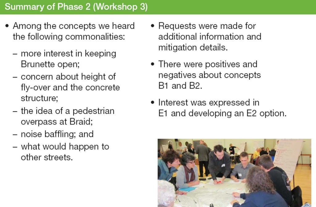
When they say that the community noted “positives and negatives about Concepts B1 and B2” or “Interest was expressed in E1 and developing an E2 Option”, they are being selective in their interpretations. From the conversation I had coming out of the last meeting, most people wanted to see better justification for tossing Concept C aside, and none thought B1 was any better (and was potentially worse) than the old “T junction” that was rejected in December. The E option was preferred by everyone I talked to (except those who still thought the best option was to build nothing).

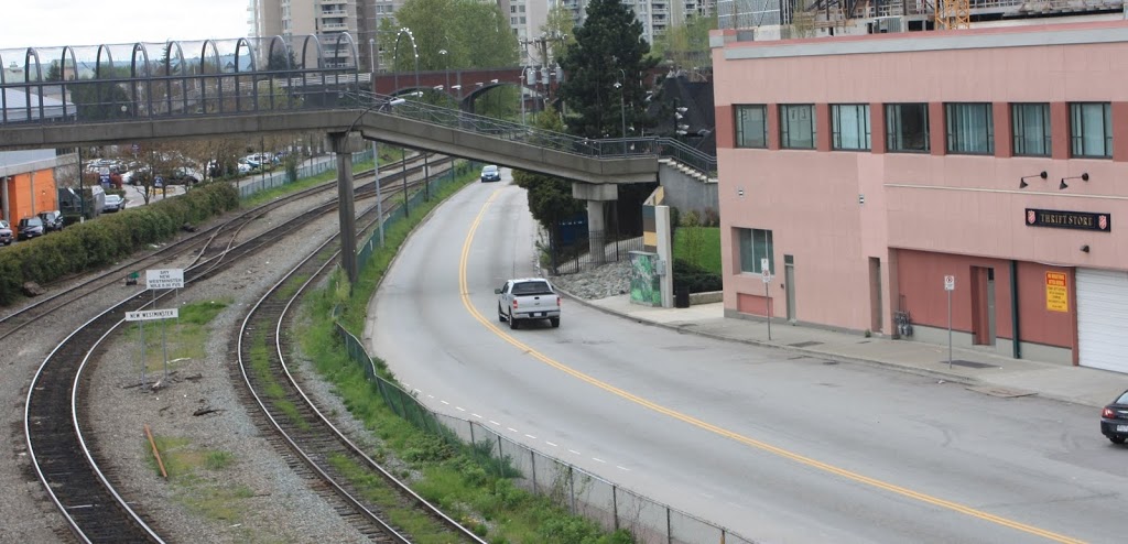
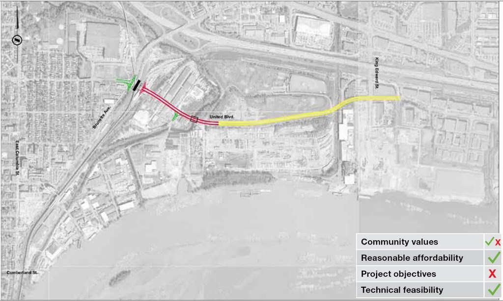
I have already posted on the Christmas Gift List of the proposed “improvements” to Front Street, so I will avoid repeating myself.

Click to zoom in

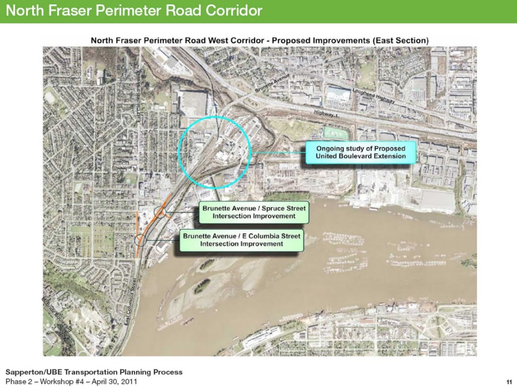
The plans further east, including plans to improve the Spruce Street intersection, are a new twist, however. This has not come up before in these discussions, and provides an interesting contrast to removing the rail crossing at Braid – they want to increase truck traffic at a level crossing a kilometre west of where they are spending $170 Million to eliminate a level crossing for truck safety? That said, the proposed improvements for Columbia at Braid would result in significant improvements to the traffic flow, discourage trucks from going along East Columbia, and potentially improve the Central Valley Greenway. The City should look at this option for that intersection ven after the UBE has finally been killed.
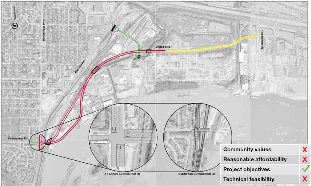
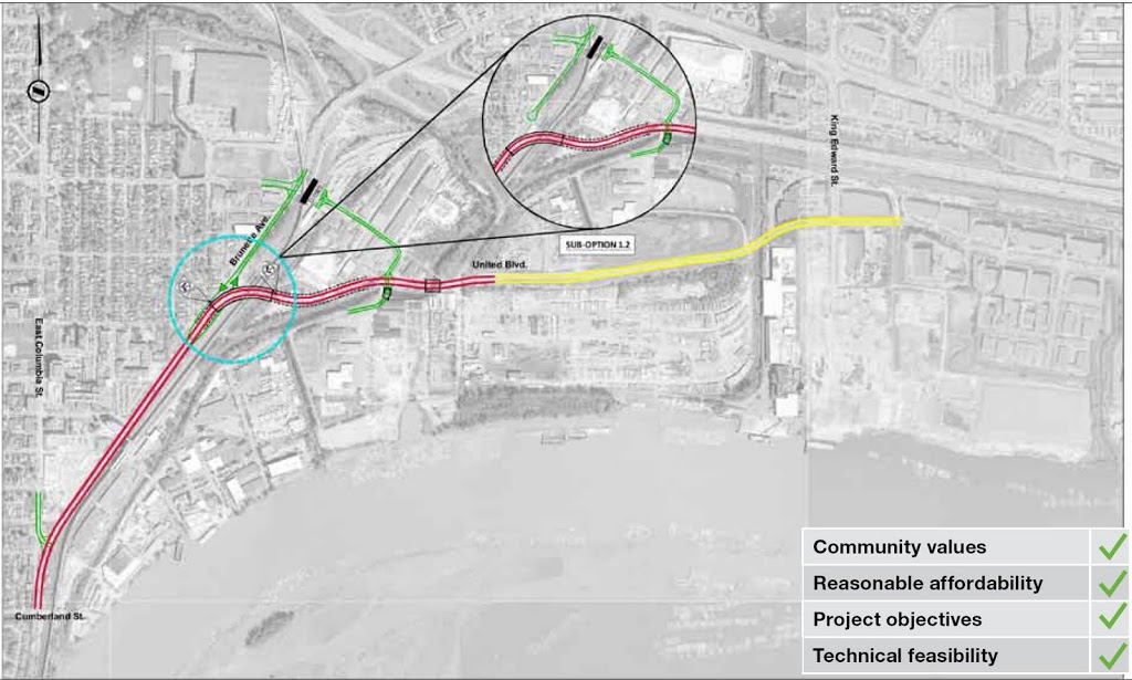
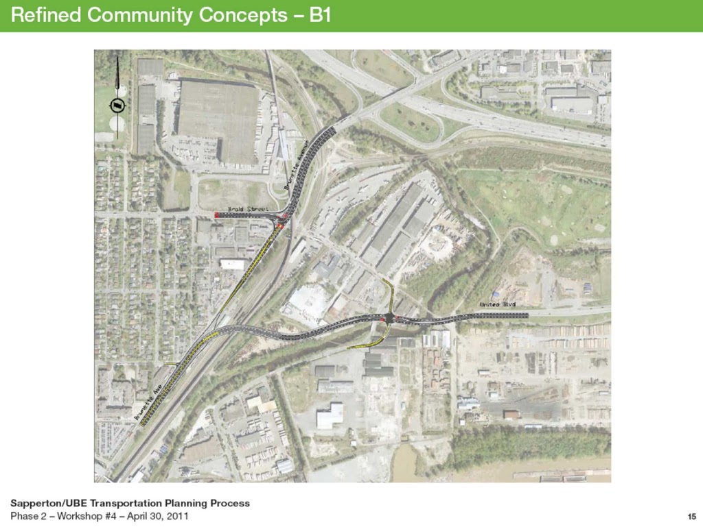
Refined Concept B1:
Note I didn’t call it a “community concept” like TransLink does. I’m not going to sugar-coat this: these concepts are coming from TransLink, not from the Community. If I go to Key West Ford and Jaimie tries to sell me a black F-150, but I pick one out with white paint and alloy rims, it doesn’t make me the guy who designed and built the truck. I’m just the guy who bought it. It is still a Ford.

click to zoom in

This is the plan that TransLink wants to build (there, I said it). The problems should be obvious to anyone following this story. The size and scale of the overpass will impact much of Sapperton. Only a few properties will be directly damaged, but the large overpass will be in dozens of backyards. This is really just a warmed-over version of the earlier rejected concepts.

The new twist that makes this even worse for Sapperton is the re-design of Brunette, where two lanes from the freeway shrink to one just north of the overpass. This will of course result in a merge zone backup. And what happens every morning when that backup gets as far as Braid? The traffic will natural bail out and go up Braid and wind its way through New Westminster neighbourhoods, the “rat running” that Sapperton was hoping to see come to an end. The back-up of vehicles coming east along Brunette and headed for the Freeway will be just as bad as they need to drop to a single lane. So much for free-flowing traffic on Brunette.

TransLink’s response to this was that the drivers will instead go over the overpass and take United Boulevard. This seems fanciful, considering anyone headed for the freeway or points east is not going to want to drive 5 km along a 4-lane commercial street with stop lights, past furniture stores, the casino, and the new Fraser Mills residential neighbourhood with it’s 10,000 commuters in order to get onto the 10 lane freeway that is less than a kilometre away…Or am I missing something?
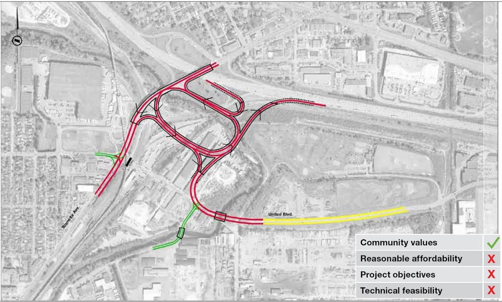
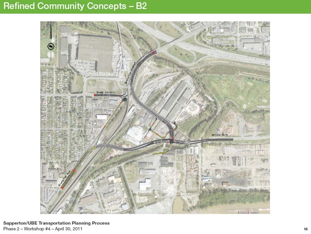
Refined Concept B2:

click to zoom in. Do I have to keep saying this?

This project takes most of the negatives of B1, with the exception that it doesn’t cause as much back-up on Brunette. As a trade-off, it impacts more New Westminster industrial land, builds a set of intersections with significant navigation challenges to cyclists (It took 10 minutes for me to show the TransLink representative that the routes for bikes here just didn’t work out). Worse, it completely cuts Braid Station off from the rest of the community and points east. This design also looks like it will cost TransLink 2 or 3 times as much as the original design, with that much more elevated overpass construction, much of it over working rail yard. This may represent a cost equal to the Evergreen Funding Gap.
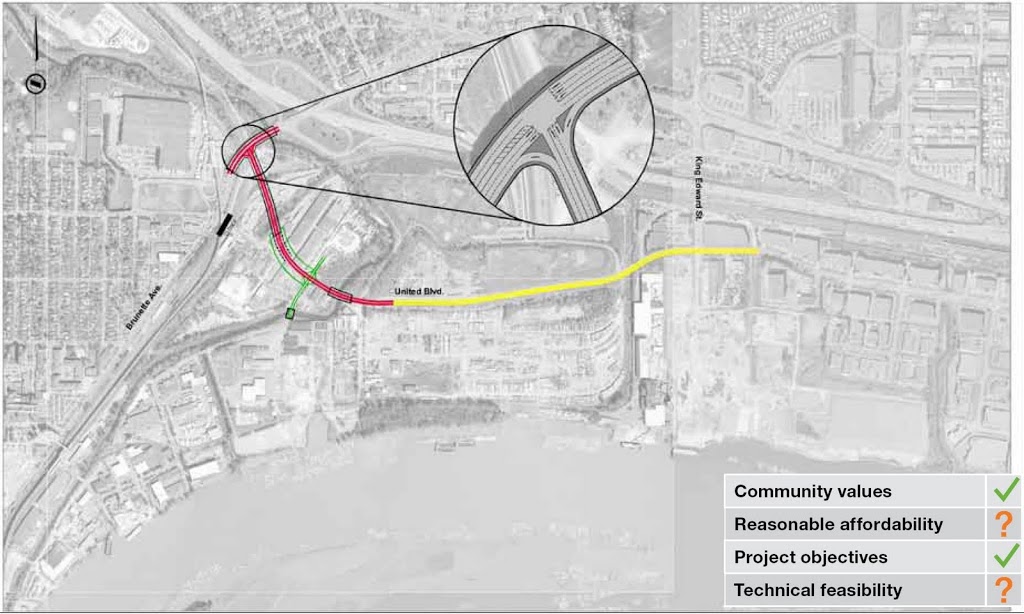
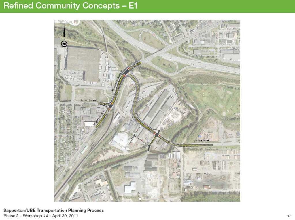
Refined Concept E1:

Guess what happens when you click

This concept definitely has more community support than the “B” concepts, mostly because it has much lower impact on the residential and commercial properties in Sapperton (but possibly a bigger impact on the Industrial properties is it meant to be servicing). TransLink has suggested the location of a new light-controlled intersection between the Freeway and Braid presents congestion challenges that may not be surmountable, and it is hard to argue against that point. Perhaps there is a creative solution to be found in creating an interchange where the intersection is currently shown on Brunette, but it got me wondering if it might just be easier to make it only two lanes instead of four. If the purpose is to bypass the level crossing at Braid, isn’t two lanes enough to still “free up traffic”?

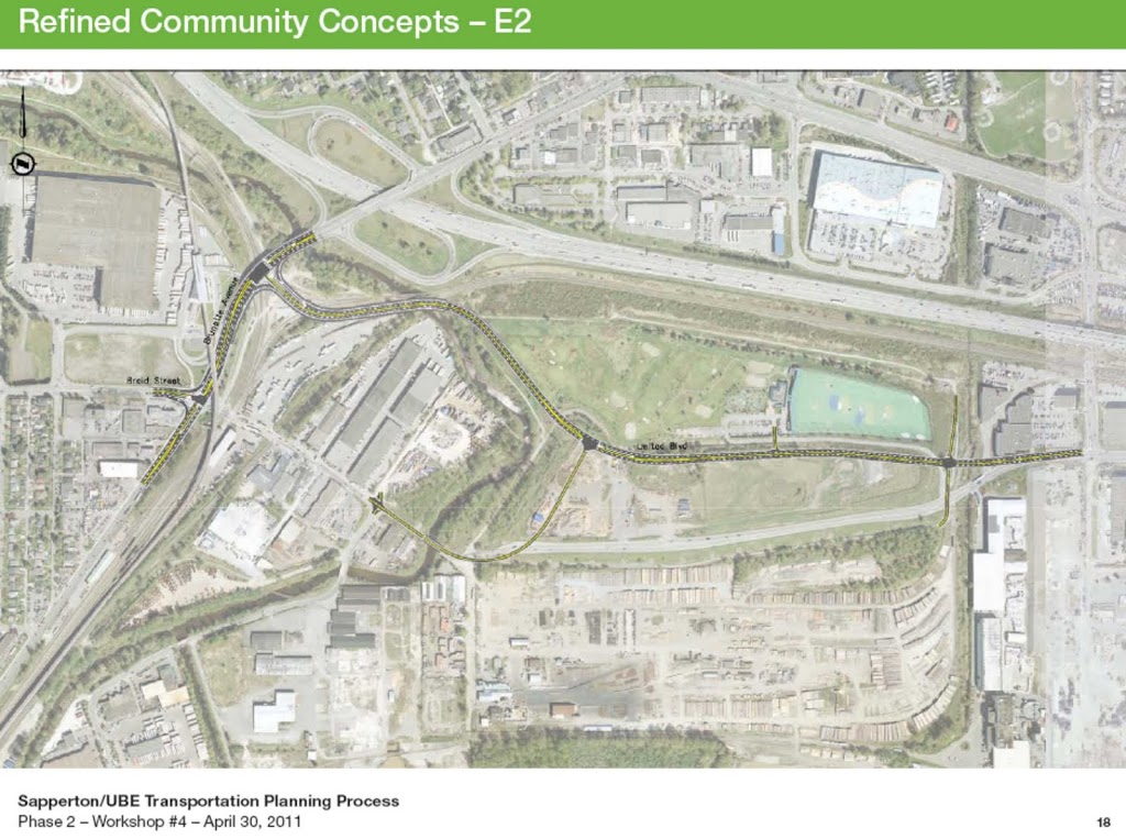
Community Concept E2:

Don;t click this one, or it will zoom in.

This one did actually come from the community. There are a few problems with how it was worked up by TransLink (mostly, there is no need for the new intersection at the west end of the golf course – just direct traffic to the Braid Industrial area along the “old” United Boulevard and the Bailey Bridge, and direct the through-traffic along this new road). The big advantage is that the land being removed from the property tax rolls here is in Coquitlam, where they want this road, not in New West, where we don’t. TransLink suggested there were engineering challenges building a road on the old landfill (to which my answer was –yeah. So? Wasn’t Highway 1 being build on old landfills? And sections of the SFPR? And IKEA?). But the major point to make with this concept is that it looks better than E1 because it is closer to the Freeway. In fact, moving it to the north side of the Golf Course makes it look better yet. This road looks better the closer you push it to the Freeway, which again raises the question of why not just put the Trucks on the Freeway, and keep them off of local roads?
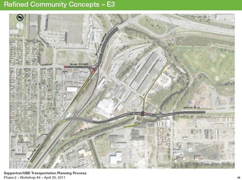
Refined Concept E3:

is this caption redundant?

Uniquely combines all the negatives of the other plans with increased cost, and no apparent gain. Dead in the water.

One concept that did not come up for discussion was presented by Voony on his Blog:

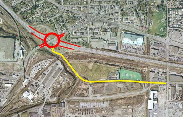
This offers all the advantaged of the “E”s, and actually frees up movement around the Braid interchange without increasing road capacity.

And it is not that unusual, and multi-lane roundabouts are now the MOT’s preferred method to deal with these type of geometrically-challenged intersections, or those that need smoother flow without increased road capacity… sound familiar?  Voony even offered and example from France:

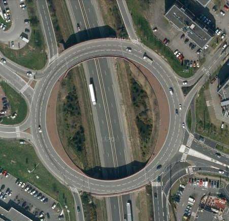
An example closer to home that eerily similar to the Brunette interchange issues can be found in Chilliwack.

Well, those are my opinions the “refined” options, but much of the Workshop was on the topic of mitigation details, and fancy garlands they plan to hang on the sides of the overpasses to make them pretty. My frustration is turning into a headache, so I will save that for another post…

Short post on a positive development

I think this is good news for the City. Yeah, it is just a warehouse, but it is a huge warehouse: at almost 12 acres, it will have a 20% bigger footprint than BC Place. The few dozen jobs it provides are less important than the security of knowing that New Westminster’s largest industrial employer is investing further in the community. It is also good to have brownfields put back into the industrial tax base.

Go ahead, call me a faux environmentalist for saying good things about a stinkin’ paper mill, but Kruger is an example of value-added manufacturing for our domestic renewable resources, and have taken many steps to reduce the environmental impact of their products. Kruger is one of the leading producers of paper products from post-consumer fibres (that stuff you put out in the blue box). Here in New Westminster, they recently invested in a biomass gasification system to vaporize then burn scrap wood and paper and reduce their need for fossil fuels. Making paper can, ultimately, become a sustainable industry, and these small steps are heading that way down that very long road (maybe if we can all stop demanding that the paper we use to wipe our privates is whiter than the drifting snow? Ah, never mind)

As a caveat, any time you talk about a half-million square foot warehouse, you need to talk about how things are going in and out of the warehouse. This may represent a significant amount of truck traffic coming to the area of Queensborough that is already suffering from a freeway pushed through the middle of it and all the congestions, noise and emissions that come with it. The good news is that the Queensborough Landing site has two advantages: an adjacent rail spur, and an adjacent river. The river especially opens up and exciting opportunity: this could be a model situation for short sea shipping. The Kruger plant is 5km from this new warehouse by road (and that includes in increasingly-congested Queensborough Bridge), but it is less than 2km by the North Arm of the Fraser River. Kruger can reduce it’s greenhouse gasses and fuel costs significantly by using small barges to move goods between the two sites along a lightly-used piece of tidewater. This seems like a no-brainer, but I say this without knowing what regulatory nightmares Port Metro Vancouver might put in their way. It seems PMV is more interested in moving trucks around these days than dealing with actual floating things. Kruger has demonstrated an interest in being environmentally innovative in the past, let’s hope they follow through here.

Call it greenwashing if you want, but compared to some industry’s approach to the environment, it is good to see new Westminster’s largest manufacturer taking measurable steps in the right direction.

I’m not just saying that because they sponsor curling. But it helps.

On a Four-Lane Front Street (UPDATE!)

I haven’t blogged on the topic of the fourth TransLink Workshop on the UBE yet, mostly because I waiting for TransLink to put the materials from the latest workshop on line (which they have just done!). so I will get on that next and discuss at length the latest coat of polish applied to that particular pair of old shoes.

In the meantime, I want to address the bigger issue, the one that seems to be the source of much of the push-back on the UBE: the idea that the UBE may worsen our traffic problems City-wide, not make them better. For the first time during these workshops, TransLink brought some materials to address this concern. As part of their pre-workshop presentation, Delcan presented a single PowerPoint slide that showed how they plan to address the NFPR in New Westminster. It was short on detail (there was not timing or budget mentioned) and there were no graphics except an image of the current proposed NFPR route with word-clouds pointing to several proposed improvements, paraphrased here:

1) Widening Front Street to 4 lanes;
2) Re-aligning the intersection at Columbia and Brunette so that Brunette is a continuous road and Columbia joins it at a “T”;
3) Doing a similar realignment at Front so that the Front Street-Columbia-east connection is a thoroughfare, and Columbia Street-west joins at a “T”;
4) Again making the Front Street-to-Stewardson a straight shot with Columbia meeting it at a “T” west of Hyack Square;
5) Tearing down the Parkade; and
6) Re-aligning several intersections on Stewardson, including Royal Ave.

Click to zoom in, TransLink’s Christmas Wish List.

At this point, this list is akin to my thumbing through the toy section of the Sears Christmas Catalogue when I was 7 years old and checking off the toys I wanted (Lego: check! Matchbox cars; Check! Smash-up-Derby? Check! Hungry Hungry Hippos? Why not!; Millennium Falcon? Double Check!). There was about an equal amount of planning and budgeting for how I was going to get those Christmas presents as there is here.

Making Front Street four lanes is going to take significantly more than a sweep of the hand or drawing a grey dotted line on a map. As much as I agree that White Elephant Parking Inc. should go, it is hardly the only limiting factor here. As Matt Laird keeps asking: are you going to move the Keg building and the Sally Ann, or the rails? Where the rail grades separate to the east; which of the two is going to have to go? What of the rail and Skytrain underpasses? Currently there isn’t room for a sidewalk on Front, and you want to install two more driving lanes?

Then there are the intersections. East Columbia at Front has no room for a T-intersection, as the tight “Y” there now is sandwiched between rails and (I kid you not) a “Heritage Wall” whose ultimate immovability has been used by the City to argue against pedestrian- and cyclist-safety improvements at Columbia and McBride. At the other end, what will Hyack Square look like attached to a new T-intersection onto the truck route?

And I don’t know if anyone else noticed, but since the recent traffic calming around Stewardson between 3rd Ave and 5th Ave, the traffic back-up getting onto the Queensborough has noticeably expanded, as has the back-up on 6th Ave to get to the bridge, and the congestion coming off the bridge down the hill along Stewardson. With a less-fettered through-shot to Freeway offered by a doubling of Front Street, does anyone imagine that Stewardson is going to see less traffic? When (or more importantly, where) is this game of Whack-a-Mole going to stop?

Through this very few people are asking the City if they even want an inevitably-congested 4-lane limited access road cutting the City off from it’s waterfront forever. For too many people, it is taken as inevitable that this will happen, and we need to manage the “mitigation” as best we can.

Please people, take a trip to Downtown Seattle before you make that call. If you lack travel funds, but have some imagination, just go down to the Front Street Parkade and look at the ass end of the businesses on Columbia: wood that hasn’t seen paint in 50 years, bricks swollen with too many layers of peeling paint, tarps keeping the leaks out, broken or boarded up windows, rusty chain-link and barbed wire, graffiti, garbage, shopping carts, blackberries and ivy…

This is our City’s waterfront. Despite the efforts of the Antique Alley merchants, it is a dark and dismal place. In many areas, the general dilapidation is embarrassing, and will only become more so as the Pier Park draws people down to the river: this is what they will see when they look back. This will be the face of New Westminster to those visitors.

Now tug at the braids of your imagination a bit and think about what could be.

It could be full of vibrant businesses and comfortable homes, just as Columbia Street is. It could be opened up to let the sunlight in and the exhaust out. It could be made pedestrian friendly, it could be safe and attractive. The empty parking bays could be courtyard restaurants, or pocket green parks. The Antique Alley businesses could see walk-by customers again. The entire downtown could be improved with new high-value commercial real estate providing jobs and tax revenue.

We don’t need to completely remove Front Street or the rails to do this, there is plenty of room for two lanes of Front, three rail lines, and a wide sidewalk with trees, planters, and even curb-side parking and café seating. White Rock’s boardwalk doesn’t suffer greatly from the existence of rails, it actually adds some charm to the location, and here rails can serve as homage to the City’s proud history as a working waterfront.

Put a 4-lane express route through there, you can kiss this bright future of Front Street goodbye. That would be a shame.

With transit-and pedestrian-oriented development along Columbia, including the MUCF, the Inter Urban, Plaza 88, and with the road diet on Columbia and resultant accessibility of the businesses, there is a resurgence of the Heart of our City. You can’t argue with the business development, with the people on the street, with the positive vibe down there, a sharp contrast to 20 years ago. I can’t shake the feeling that we are approaching a tipping point, though, and the opportunity exists now to build on that momentum, and grow the Heart of the City down to the water, to link it to Quayside and the resurgent River Market, to continue building the Heart of the City up 6th to the new high rise developments (and beyond?), and west to connect to Columbia Square (and beyond with the re-purposing of lower 12th?). Or we can let New Westminster remain a place of unrealized promise, much like it was for the second half of the 20th Century.

The UBE is the beginning of the NFPR process, and I have said before and will say again: no single project is going to have as big an impact on the future of our City than the NFPR. So let TransLink figure out if it is technically or economically feasible to complete (many of us clearly have doubts), but in the meantime, this City has to start discussing whether it is socially feasible.

UBE – Phase 2 consultation, and the skill of listening.

Again, there is so much going on right now that I am slow to Blog about it all. This week’s event included the TransLink workshop on Wednesday night – The beginning of Phase 2 of their revamped consultation process for the proposed United Boulevard Extension.

The turn out was pretty good, and it looks like about the numbers TransLink (or their facilitator) anticipated. They had 8 tables set up, and there were about 10 people per table, with a lot of TransLink and City staff milling about as observers (just to be clear- this was a TransLink-run show, and I didn’t hear City Staff or elected folks advocate for anything other than having the conversation. Well, except for when Councillor Harper very astutely asked no-one to talk about the Hockey Game, as many in the crowd were likely recording it).

The evening started out with a presentation from the facilitator, with input from the design consultants from Delcan. The presentation is available here.

They opened up by making it clear that none of these concepts would be compared to the “unspoken option”: doing nothing. TransLink wants to build this project, so they are going to try to come up with a satisfactory project. If none of the concepts they come up with are ultimately satisfactory to the City, then TransLink will take their ball and go home. But none of these projects will be compared to “no project”, they will only be compared to each other. I suppose this leaves the “no project” open for discussion in the community once they have honed down the TransLink options to one. And that might be an interesting topic. (Is anyone thinking about what would happen if TransLink walked away and the Ministry of Transportation and Highways takes over this project? You think they will be interested in community consultation?).

They then outlined the Objectives of the project, which can also be read into by the cynic:
1:Improve safety and reliability of people and goods movement (they have slipped “people” in there, as an admission that it will be a commuting short cut, not just a truck route. I would suggest removing all traffic would make it reliable and safe, but I think they are going the other direction); 2: Reduce Excessive GHGs caused by idling (again, hedging their bets, they are not reducing GHGs, only the excessive ones caused by idling. More vehicles will undoubtedly resulti n more GHGs overall); 3: Support Alternative Modes (Great, I like this one, although this seems a little more like tolerating alternative modes than building with them in mind); 4: Removal of at-grade crossing at Braid Street ($170 million will buy you a lot of Jersey Barriers); and 5: Meets Partner’s Objectives (which are less well defined, but making New West Council happy is definitely under this category).

After this they rolled out 5 basic concepts that came out of the earlier consultation meetings. There is no doubt there is a bit of a sales job going on. That isn’t a criticism; part of the facilitator’s job is to sell the merits of the project on the audience. Walking into a potentially hostile crowd like this, some sales savvy is needed just to get the conversation going. One common sales technique they used is to make us own the project. They kept reinforcing that “these plans are your plans, made by the community during phase 1 consultation, not our plans”. This gives the audience a sense of ownership – we are likely to be less critical of our own ideas than someone else’s… this is why an shrewd salesman has you list your desires before giving them back to you, often adjusted to fit the product he has in front of him.

So let us review:

Concept A – Click to grow

?
Concept A had a new road paralleling Brunette on the other side of the tracks, then somehow connecting to Columbia further west, or even to Front Street directly. This plan is basically dead in the water. It would nuke an unacceptable amount of New West industrial land; it would no doubt trigger an Federal or Provincial Environmental Assessment process that TransLink does not have the time, money, or community support to go through; it just moves the overpass to another neighbourhood (and would need a bigger overpass), would end any plans to develop our waterfront east of the bridges for park or industrial use, and it would be prohibitively expensive. Really, this plan was not further reviewed, for good reason.

Concept B – Click to grow

Concept B is little more than the previous overpass plan of 2010, warmed over a bit. It lacked detail on how lanes would be distributed, but it connects United Boulevard directly to Brunette over the Sky Train Dip, and reduces Brunette to a lesser road (or even dead-ends Brunette at the overpass). Although this was one of the Concepts discussed at length, it seems no more satisfactory than the original plan: we are still talking a 15-foot high overpass with trucks on it, so the liveability impacts on Sapperton are still there. It also presents some problems for transit connectivity to Braid Station. Finally, it seems to direct all of the trucks moving along Brunette to United, when most of them are trying to get to Highway 1. This is about a polished as the original UBE concept could be, but all the polish in TransLink’s arsenal isn’t enough to make this anything but a turd.

Concept C – Click to grow

Concept C might be the best for New West, but was not considered further as it did not hit TransLink’s objectives (very little support for this bold assertion was made, it just didn’t meet their objectives, end of story). This concept was to simply close the rail crossing (those Jersey barriers I mentioned) and replace the Bailey with a bigger bridge. This would allow the industrial traffic to access Highways 1 and 7 via the Bailey Bridge and the new King Edward Overpass (the City could get involved in improving the Spruce Street situation to better serve their industrial customers, but we can talk about that later), it will effectively stop rat-runners through the industrial area, will make the rail crossing safe, will make the Bailey Bridge friendly for peds and bikes, will be cheap to build… but I guess Coquitlam would take New West to court of this was suggested.

Concept D – Click to grow

Concept D involved numerous bowl-of-spaghetti options for an interchange connecting United to a re-vamped Brunette interchange. Don’t let the petroglyph-turtle design wow you too much, this is a really costly and impractical option and would require significant contributions from MoT (who are already a little over committed these days) and building over a big hunk of railyard that ain’t going anywhere for anyone. For all sorts of reasons, this concept is also dead in the water.

Concept E – Click to grow

Concept “E” was the idea of connecting United Boulevard to Brunette between Highway 1 and Braid. This was, by far, the most popular option in the room ) seemed the most popular. It was even suggested that losses of New West industrial land could be reduced by running the road though the Landfill adjacent to the Golf course on the Coquitlam side of the Brunette. Coquitlam wants this damn road, why don’t they sacrifice some tax property instead of New West losing limited industrial space. The Bailey Bridge could remain, and the Braid industrial area connect to the new connector by crossing the Bailey and getting onto the existing United. Of course, this concept looked better and better the more the route is pushed towards Highway 1, raising the question: why not just put the traffic on Highway 1, put the $170 Million into busses and Evergreen, and end this painful process?

In the end, we won’t know what the real concept is until they come back on the 30th with some useful plans. The concepts shown were very high-level, and the implications for traffic planning, GHG, costs, were not there to evaluate the options. That said, there are a lot of people in the room who think this consultation process is a sham, and it was often hard at my table to have a meaningful discussion with the facilitators and the Translink staff when people are calling them liars and doubting their professional expertise. The transportation engineer at my table was very patient to the abuse hurled at her (much calmer than I would have been). It is too bad that the one loud guy at my table was constantly complaining that TransLink was not listening and their minds are already made up, when the complainer clearly had already made up his mind and was not listening.

Overall, I think the consultation process is working, but I have not yet been convinced that they have come up with a plan that suits our needs as a City (although “Option E” might be getting close). Mark me as “cautiously optimistic”, but that is pretty much my nominal status…

What was strangely missing was any acknowledgement of the requirements the City Council made for this project: a realistic plan to manage the traffic west of the UBE in such a way that we are not just moving the pinch point closer to downtown New Westminster. All this talk of “community concerns” is kind of empty without addressing the one Concern that New Westminster Council has repeatedly raised: what about Front Street?

As an aside, you want to talk about community? There were 100+ people in the room, several of whom were watching Game 1 on their portable devices, or at least checking in on the score. At not time did anyone cheer or boo, and at not time did anyone announce the score, recognizing that many of the crowd recorded the game. The rest rushed home to catch the third, and were rewarded for their efforts.

on being visionary, one Clear, Open Stream at a time…

I just had the Sustainable Communities equivalent of a Stones fan meeting Mick. I had a chance to meet and hear a talk by one of the major rock stars of sustainable Urban Development.

Dr. Kee Yeon Hwang is the President of the Korea Transport Institute, which is a somewhat unusual organization in the Canadian context: a policy research think tank, populated by academic experts in the field, that works directly for the Prime Minister. Dr. Hwang was visiting Vancouver as a Visiting Fellow in Urban Sustainable Development at the SFU Urban Studies Program. While here, he gave two public lectures, one on the Cheonggyecheon Project, and one on Seoul’s bus transit system. The sharp end of my curling season meant I could not attend the evening lectures, but Councillor Cote managed to arrange a visit to New Westminster for Dr. Hwang, which included a walking tour of the City’s waterfront, and a presentation by Dr. Hwang to members of City Council and City staff in Transportation and Planning. Councillor Cote invited members of the City’s Bicycle and Pedestrian Advisory Committee, which is how I got into this great talk. The topic, Cheonggyecheon, is relevant and timely in New Westminster, with all the recent talk of North Fraser Perimeter Roads and United Boulevard Extensions, and the City entering a Master Transportation Plan process.

“Cheong Gye Cheon” can be roughly translated into “clear, open, stream”, which as a name was remarkably ironic, but is now iconic. The short version of the story is that the City of Seoul took 6 congested kilometres of stacked 12-lane freeway and solved the congestion by simply removing the road and replacing it with an urban stream and greenway/linear park, sparking a urban renewal in Seoul that is still going on today. But there is a longer version of the story, and I will try to condense Dr. Hwang’s talk here (based on my notes, so any factual errors are very likely mine!).

The history of Cheonggyecheon is of a small, ephemeral stream near the centre of Seoul. In the early 20th century, there were less than a million people in Seoul, and this stream was a water source, a place to wash clothes, and an open sewer, much like streams in developing urban centres the world. Things did not improve with the economic collapse around the Korean War. Post-war the stream was mostly home to squatter houses and squatter factories. Between sewage, waste, and dyes from the unofficial textiles industries, the stream was very polluted, and often ran multiple colours. When Dr. Hwang was a child, this was considered the “bad part of town”, with poverty and all the crime that comes with it.

Cheonggyecheon in the post-war period.

With the rapid development and industrialization of Korea in the 1970’s, there was little resistance to burying a small, heavily polluted, ephemeral stream in the bad part of town, and capping it with 8 lanes or surface traffic and 4-6 lanes of elevated traffic. Seoul was the heart of Korea, and building major freeways was a point of national pride: this is the progress Korea needed to become a leading world economy.

Cheonggyecheon expressway in all its glory.

???

Fast forward to 2002. Seoul is a modern “world class” city of more than 10 million people. The elevated Cheonggyecheon expressway is congested, the original watercourse has been buried in underground vaults and culverts, and the space between is nothing short of disaster. No sunlight, polluted by vehicles, traffic congested, not accessible to pedestrians as all open spaces are taken up by travelling vehicles, commercial vehicle parking, and unlicensed retail operations (street hawkers). The buildings were aging, and there was no impetus to improve them in this undesirable setting, so the businesses were declining. This was just one of the epicentres of overall urban decay in Seoul. Although they had built the trappings of a modern city, with advanced infrastructure and large dense population, the residents and officials in Seoul were realizing their quality of life – the liveability of their City – was lagging behind cities that were considered “World Leaders”.

This begat a paradigm shift. A new Mayor was elected in 2002, and the new broom swept clean. His new paradigm including shifting from development to conservation; from building spaces for automobiles to building spaces for people; from infrastructure efficiency to infrastructure equality. This is similar to what we now call “sustainability” in urban design. The Mayor immediately announced the plan to tear out the Cheonggyecheon freeway and return it to a 5.8km-long linear park. The project was master planned in less than 6 months, and completed in a remarkable 3 years. There obvious political motivation for the fast timing, in that Mayors in Korea face the polls every 4 years. The project cost almost $300 Million (US), but the planners calculated that this amount was about the same as they would save in 10 years of maintenance of the existing highway and buried waterway system that was reaching the end of it’s design life.

Before and after airphotos – where would you rather live?

Although there was an extensive (if rushed) consultation process, including the Transportation Institute, all levels of government, and citizen representatives, this did not prevent significant backlash and protest. The protests will sound familiar to anyone who has listened to the Hornby Street Bikeway project or who might suggest New Westminster might be better off without the waterfront parkade: local businesses worried about losing traffic and customers, concerns about where everyone will park, neighbouring areas concerned that the congested traffic till get worse on adjacent streets. The illegal street vendors were particularly militant in their protests, but the project went ahead.

The road was cut up and removed (with 95% of the material recycled). The stream was exposed and re-contoured. Since most of the stream’s flow was ephemeral and partly because of other water management projects in the City, the stream was going to be dry 8 months of the year. A diversion project from the adjacent river and groundwater sources were combined to provide up to 120,000 M3 of water a day through the stream to maintain a constant minimum of 40cm of water. Storm runoff and combined-flow sewer water was separated and treated before entering the stream. Aside from the base flow, the stream was designed to accommodate the 50-year flood in a lower tier, and the 200-year flood in its upper tier. There were also 22 bridges built to cross the 5.8-km route, although many of there ware actually restorations of original bridges that were partially deconstructed and buried in asphalt in the 70’s.

The end result is 5.8-km people space. Areas are very green and organic, other parts of very hard-surface with lots of facilities to accommodate public gathering, arts, or walking. People are encouraged to interact with the water. Where the symbol of “Korean Progress” used to be a 16-lane freeway full of cars, the new symbol is of urban children playing in a refurbished stream surrounded by green. Paradigm shift indeed.

What of the externalities, and what of the protests? The complaints about increased traffic elsewhere disappeared, just as the traffic did. Ridership on the adjacent subways increased, some people changed their travel times, some changed route, but mostly, people just stopped travelling so much through the area. Adjacent traffic congestion increased less than 1.5%, but overall there was a concurrent 2.5% decrease in Central Business District traffic. Property values adjacent to the stream increased 30%, and businesses prospered as they were suddenly adjacent to a site where there were more than 50 Million visits during the first year. The air temperature in this part of the Central Business District dropped several degrees during Seoul’s hot, humid summers, as the water flow acted as natural air conditioner and created a conduit for cool breezes. All this in a public place for festivals, for lunch, for art, for living space…

One of several “under bridge Art Galleries”

However, this progress does not forget the past. At several locations along Cheonggyecheon, there are reminders of the past. Those forgetting history are doomed to repeat it.

Several columns preserved, to remind people what they lost.

How does this translate to the rest of the City? Once the success of this project was apparent, every part of the City wanted one. Other viaducts have been removed under a “sky-opening” initiative. Other significant public areas in the City have seen the removal of traffic lanes to make room for green space: effectively building for people instead of cars.
?

Seoul City Hall before…

?

…and after.

There has been a renaissance across the Central Business District, with more people moving into the area (12,000 new residential units in the CBD being planned right now), greenways popping up in exchange for density across the city, and all of the sudden, people in Seoul are finding they can walk places. With the new mayor talking up plans to refurbish their industrial river front:

Oh, and the visionary Mayor who proposed and fast-tracked this project? He is now the President of the Country.

So… the question is, are we ready in Canada, in BC, in New Westminster, for this kind of shift?


Are we ready to re-evaluate our public space and our public spending? The province is currently spending billions of dollars building more freeways, with little protest. There is huge pressure to push more lanes of “important regional traffic” through New Westminster and along our water front, and people seem indifferent, or think it will solve some problem in a magical way that has never worked anywhere else in the world.

When will our paradigm shift happen? When will we catch up to Korea? Or are we visionary enough now to not bury our waterfront under cars?

On Caps

I heard Gordon Hobbis on CBC Radio’s “The Morning Edition” on Wednesday the 16th (you can stream it here, he was on about 1:40 in) talking about the United Boulevard Extension, and it got me thinking about Gord’s business: Caps Bicycles.

First off, Gordon did a great job on the radio. He hit the right points, and really addressed the concerns the neighbourhood and the entire City have about the UBE. This despite the efforts of Rick Cluff, who not only sees the world through a windshield, but is one of the all-time worst radio interviewers (you can hear him reading the questions off the sheet, as opposed to engaging in a conversation), OK for sports reporting in Ontario, and he sure likes talking about food, but his lack of intellectual depth or nuance is fairly exposed when the conversation turns the least bit political. Locally, see Stephen Quinn for the opposite: he actually asks smart questions, uses the interviewee’s responses as a launching point for follow-ups, even if this means putting them in an uncomfortable spot, or pointing out their own contradictions…but I digress.

I actually grew up in a bike shop. When I was 7 or 8, my parents bought a small-town sports store specializing in team sports, shoes, bikes and cross-country skis. My Mom became a local legend for her skate-sharpening skills, with figures skating clubs across the Kootenays sending her bags of skates on the Greyhound, which she would stay up late sharpening so they could be shipped back out on the next bus. My Dad put 20+ hours a week in as well, on top of his regular 40-hour job as an engineer. I learned a lot from growing up around that, mostly about the rewards of working hard, about how boredom could only result from laziness, and about being part of a community instead of just living in it.

But mostly, I learned to love bicycles. I remember changing my first flat tire when I was 8 or 9. I remember disassembling all of my first bikes to their bare parts, only to see how they go back together, and I remember a 1982 copy of Bicycling Magazine that talked about “The Klunkers of Marin County”: my first introduction to what we came to know as mountain bikes. With my parents running the store, I had access to bikes. I had my first real mountain bike (a pretty marginal Raleigh) by 1984, and my second (a sweet lugged and brazed triple-butted chromoly number from Miyata) by 1985. By the time I bought mountain bike #3, my parents had sold the business, and so I went out to the open market.
?

Bike #2 – Ridge Runner SE (it was actually a 1985-1/2 model)

By 1987, the mountain bike boom had exploded. Within about 5 years, bike shops went for selling 90% “ten speeds” to selling 90% mountain bikes, and they were selling more bikes than ever before. The twin drivers of new technology advanced around mountain bikes and the emergence of Shimano SIS, along with North American cyclists like Greg Lemond, Andy “Hamstrings” and Steve Bauer finding success in Europe, cycling was momentarily cool.

The biggest bike dealer in BC was easily Caps. Even in the Kootenays, we knew of Caps, it was a big chain and always had the lowest price. So it passed that when I graduated from High school I bought my third mountain bike from Caps. It was a 1987 Diamond Back Arrival. TIG-welded 7000-series aluminum frame (rare at the time), Deore XT components, seat-stay mounted U-brake, biopace, Araya RM-20s; this puppy was state of the art for a factory-built bike. I seem to remember is selling for $1050. And I rode the hell out of that bike for at least 4 years. Eventually it saw ubiquitous upgrades like a Syncros Stem, a Hite-Rite, and Specialized Ground Control tires. It was the bike I brought down with me in 1988 when I first moved the New West. It was the bike I put slick tires on to work as a bicycle courier in downtown Vancouver. It was the bike I raced over Vedder Mountain in those “classic” races. It was the bike that opened up Burnaby Mountain trials to me, and was the bike I had when I helped build Nicole’s trail, one of the most venerable trails on that hill. I loved that bike.

My First bike from Caps… State of the 1987 art.

Then I started paying my way through school working in other bikes shops, in the Kootenays, in Vancouver and North Van. As the Diamond Back got old, I bought a Scott Pro Racing (Tange prestige, XT, Scott self-energizing brakes, and my first set of Rock Shox RS-1s), a Giant Cadex CFM-2 (aluminum lugged carbon fibre, Suntour, Rock Shox Mag21s), then another Cadex CFM-2 (same frame, AMP parallelogram front fork(!) and the last set of thumbies I would ever own (alas)). This was replaced by my first Rocky Mountain Blizzard (Marzocchi XC-600 forks, XT, gripshift, and Magura hydraulic cantilever brakes), then another Blizzard (Bombers, XT, RaceFace, V-brakes) that I still use for commuting, and now my SantaCruz Blur named Morton. That is my mountain bike history, in a nutshell. Road bikes are another matter, as are commuters.

Liz 2 – my 2nd Blizzard, now an uber-commuter and light tourer.

Now it has been 10 years since my last bike shop job (Blizzard #1 was the last bike I didn’t have to pay retail for), and I generally hate going in bike shops. Actually, I love going in bike shops, I hate going in with the intent to buy, as more often than not I know more than the sales guy I am working with about the product I want to buy, I am a terribly picky customer and have little patience for the marketing hype (don’t get me started on “riser” handlebars) and the entire sales/snob side of the cycling industry just irritates me. That said, The iCandy has purchased both of her last two bikes from Caps: a Devinci road bike for training and Grand Fondos, and another Devinci hybrid for commuting. She has a hard time finding bikes that fit her well, and both Devinci and the staff at Caps have done a good job for her. I can go in and talk to Gord or Marie or anyone else there and 90% of the time, get what I need (and the other 10% of the time, the thing I need doesn’t exist anymore…my list of bikes above makes me look like an early adopter, but I am now pretty far to the retro-grouch end of the spectrum).

It is also great to support someone who lives and breathes his community. Gord is the driving force behind Sapperton Days, an event embraced by the entire community. He serves on community committees (including previously on the Pedestrian and Bicycle Advisory Committee, where I got to know him better), and he is always up for discussion about the local events of the day. I think (from my young memories), that is how my parents were: selling baseball equipment but also coaching and providing uniforms for community teams (sponsoring 8-year olds… funny when you think about it), renting XC skis, but also providing a sales location (free of charge) for the local cross-country ski club to sell their passes. They didn’t sell golf equipment (why compete with the Pro at the local club, who is a specialist in the field and a good guy?) but they served on the board of the community golf course… build the community and your customers will reward you.

So kudos to Gord, for running a community-based business, and building the community. And shame on anyone in New Westminster who buys a bike a Walmart.

A tale of two developments

Two development projects came to light this week in the local papers, and at council chambers.

Both are planned to occupy under-utilized pieces of land adjacent to major transportation corridors, and both are going to convert unused space into economic drivers by providing jobs. However, these two projects are completely different. By comparison and contrast, they teach us about sustainable land use planning, and how it relates to sustainable transportation planning. They serve to challenge us about the type of City we want to build.

First, the good news. Bentall Kennedy (yes, those Bentalls; no, not those Kennedys), the owners of the biggest freaking warehouse in the world adjacent to the Braid Skytrain Station, are hoping to develop the lot that includes the warehouse visible from space and the surrounding empty lots.

The report to Council outlines a first phase office complex development, followed by further offices, commercial and/or residential space. They are in the early part of the planning process, and want to get out into the community to do some consultation before they roll out their final plans (hear that TransLink?), but from the media reports, it sounds like two office buildings are already moving through the process, and more to come.

Why am I excited about office buildings? Because empty lots beside a SkyTrain Station are an embarrassing lack of planning, and a big warehouse (where stuff is taken off of one truck only to be put onto another) right next to SkyTrain Station is doubly so. Building a transit-oriented development at this future transit hub (if, as Gordie the Liar once speculated, we ever get transit onto the Shiny New Bridge). Presumably, the value of that land has increased due to the presence of SkyTrain, and this property will not only provide jobs and potential living space to accommodate growth, it will provide much-needed business revenue for the City’s coffers. Much like the MUCF, a location next to a transit hub is actually a feature when attracting 21st century businesses. New Westminster, with 5 SkyTrain Stations, is only beginning to cash in on this benefit.

Note how they are going to consult with the City and the residents before they build? Absent other info, I would suggest building working and living space next to a transit station is a good idea that we should support.

Now the bad news. The big, empty space over which you can enjoy views of Poplar Island from the east sidewalk of the Queensborough Bridge (arguably a better view than Walmart over wrecked cars – the offering from the west sidewalk) is finally going to be put to use: for taking things off of then putting them back onto trucks.

No doubt strategically located adjacent to the potential North Fraser Perimeter Road, the people of Queensborough, already burdened by excessive trucks and traffic, are going to get to enjoy dozens more trucks on their surface streets. Not trucks picking up goods from New Westminster manufacturers, or delivering goods to New Westminster businesses, but just brought here, unloaded, reloaded and shipped off elsewhere. Since it is Port Metro Vancouver land, we don’t even get the Property Tax Benefits of having a commercial distribution hub. More traffic, more road wear, minimal tax benefit. Bad idea.

Notice how the Port didn’t ask to do this, but sent a letter to the Queensborough community telling them they will be doing it? They are the Freakin Port of Freakin Metro Freakin Vancouver: they don’t need no stinkin’ consultations.

If we were consulted, what would we say? Unloading, storing and loading trucks is, perhaps, not the best use for our valuable waterfront industrial property. Although the Port originally promised short-sea shipping at this location, that seems pretty unlikely now. If you look at Port lands along the Fraser, less and less of it is involved in putting things on or off ships, and more of it is becoming a tax-free and lucrative place to build truck-only warehouse complexes. The job creation is minimal, the tax benefits are limited, and the environmental, economic and social costs of increased truck traffic in our neighborhoods is significant. The former Interfor lands, if not a place where manufacturing can take place, could at least be a location where short-sea shipping can reduce the need for the North Fraser Perimeter Road, for the United Boulevard Extension, for lines of trucks backed up on Stewardson every morning…

What do these two projects say about Urban Planning? To quote the ghost of Shoeless Joe: “if you build it, they will come”. Metro Vancouver is growing, but the type of growth we will see in New Westminster depends on the growth we are building to accommodate. Do we want relatively dense office and commercial development next to residential spaces, connected to the rest of the Lower Mainland by an integrated transit and greenway system (i.e. Braid Station, the MUCF, the Brewery District, Plaza 88)? Or do we want our roads full of trucks, connecting inefficient goods-shuffling (but not manufacturing) businesses spread out along our waterfront and through our neighborhoods?

If we build truck routes we will get trucks. If instead we build a modern, integrated system to move people and goods, we will more efficiently move people and goods, and become an attractive place for transit-oriented development.

…and on an almost completely unrelated note, the UBE is coming back to the table on Saturday.

MUCF Public Hearing

tonight was School board, victory and loss on the Bottled Water issue, more on that later. For today, all I have is video and comments from Monday night’s Council discussion around the transportation issues at the proposed MUCF. Video courtesy Matt Laird (So my Mom can see I still need a hair cut, my wife can complain about all my “um”ing, and my Anonymous Stalker can pick me out of a crowd)

Yep, I’m a goof, but the answers received from staff were slightly unsatisfying. I didn’t think that this was the forum to engage in a protracted debate, but I did have a great discussion after with a VP from Uptown Property Group. Things I learned:

Moving the garage entrance to Begbie is challenged by the slope of the lot. The building lot is several metres higher in the northeast corner than it is in the southwest corner, placing the ramp over on the east side would make for a steeper ramp and not allow as much parking capacity. To hear City Staff talk about it, moving the garage cannot be done.

First off, in my consulting days, I was taught by a senior engineer to never say “it cannot be done”. It can always be done, it is a matter of priorities and costs. Having the parking entrance on the east side of the building is, in my opinion a HUGE priority, so let us see the economic argument about whether it can be done. Some of the slope issue could be addressed (and I thank Matt Laird for pointing this out) by creating the ramp parallel to the building where the angled parking on the east side of Begbie currently sits, or working the ramps into the Alexander Street end of the site. The Gentleman from Uptown pointed out that the tiny retail space on the northwest corner is a compromise due to the desire to have parking on the west side of the building, moving the entrance to the east will also improve this property, increasing the value of the building. I stand by the idea that having a garage entrance on the west side of the building is both unsightly and unsafe, and challenge the engineers and architects to come up with a better solution.

Second, with all due respect to Mr. Lowrie (who I think does a great job for the City), the response that Begbie has always been the designated bike route connecting the CVG and Carnarvon sort of avoids the issue: the original decision was wrong. Time plus wrong does not make right. This is part of ongoing discussions at the VACC, at the City’s Bicycle and Pedestrian Advisory Committee, and amongst the NWEP transportation group: the bike plan for the City consists of green lines on a map that are evenly spaced to create “coverage”, but do not reflect the reality of riding a bike. Begbie is not an appropriate bike route when 8th ave is a couple of dozen metres further west and is way more accommodating to more cyclists. The City’s Bike Plan includes Tenth Street as a major north-south route through town. The 200m of Tenth between Royal and Queens is over 13% grade! It is crossed by major traffic route at Royal (where cyclists coming down tenth will be overheating their cantilevers to avoid drifting into traffic) and a completely blind corner at the top of a steep hill at Queens. and a 13% grade. As my French friend would say: Hors Categorie! To suggest that is the correct spot for a bike route is ludicrous, it might be the most difficult and dangerous north-south route in the City for bikes. Although Begbie is not as bad as this, it is likely to see much more traffic due to the location at the CVG, near the SkyTrain, and around the new MUCF. Move the bike route to 8th, so it can actually be a bike route and not just a convenient green line on a map.

Finally, and I have to call attention to this, it is suggested in the design and was confirmed by the architect from Uptown, that the mid-block crosswalk at 8th in front of the SkyTrain station will be removed. The NWEP fought to have that crosswalk installed, and make no mistake we will fight to have it maintained. That crosswalk is an important part of the pedestrian infrastructure in New Westminster, it is heavily used, it serves to protect the lives of New Westminster pedestrians at the front of our busiest Sky Train station, and it will only become more important with the MUCF and the completion of the Plaza 88 development. It was installed to save lives, it should continue to do so.

Before that crosswalk was installed, people walking out of the Skytrain wanting to cross 8th were asked to walk up or down the street a half block, in the rain, to the corner of Columbia or Carnarvon. The mid-block crossing not only provided a more direct crossing, it offered the rain shelter of the Skytrain line. Naturally, people jaywalked, creating a safety hazard for cars and busses before the crosswalk was installed. The City wanted to install a fence down the middle of the road to solve the jaywalking problem, not recognizing that the problem was one of bad design. The NWEP fought the City, forcing them to recognize that Pedestrians had as much right to the street (especially at a Skytrain entrance!) as cars. Reluctantly, the City installed the crosswalk as a temporary measure. It is still there, it is still safe, and it is still used.

With the introduction of a left turn lane to access the MUCF, I guess the fence idea is pooched. With new retail and restaurant activities on the east side of 8th, the pedestrian traffic will only increase. Does the City think the people coming out of the Skytrain will now walk to the corner of Columbia (in the rain), wait for a light (in the rain) then cross, to get ot he MUCF from the Skytrain, or from Plaza 88? Of course they will stay under the cover of the Skytrain, and they will Jaywalk, right in front of cars pulling into or out of the MUCF. Conflict will ensue. Someone may get killed.

Again, the root of this problem is the parking entrance on the west side of the MUCF. How many compromises are we making for this one design fault? Let’s do it right.

More Transportation News…

A few interesting stories have arrived in the media this week involving TransLink, transportation planning, and tolls.

The tone of this story was surprising, especially when juxtaposed against the opinion piece that the editor of that same paper produced last month. The ”danger” facing the NFPR is that it is a bad idea that does not fit in our community. Indeed, unless TransLink comes back with something substantial to mitigate the traffic impacts on all of New Westminster, from Brunette to Queensborough, then this plan may indeed have to go away. I do not think that is something to fear, however, it is the new reality of transportation planning. Clearly, the UBE as proposed in December did not fit the bill; we need a better solution.

The days when you could plow freeways through neighborhoods ended in Vancouver in the 70’s; perhaps it will end for the rest of the North-of-Fraser area in the 10’s. The South-of-Fraser communities will have to come to their own epiphany about this, and there are groups trying to usher that day along, but I am afraid as long as Diane Watts and Kevin Falcon are in charge, they will be mired in asphalt.

The Mayor is back to talking about tunnels and tolls, which are all well and good, but this raises as many questions as it answers. Is a graded, 2-km long 4-lane vehicle tunnel the best way to spend $1 Billion? Will a tunnel serve the primary purpose of a goods movement corridor if it will not be permitted to transport dangerous goods? What will either end of the tunnel look like? How does this tunnel free up traffic at Queensborough Bridge (as Councillor Osterman was quick to point out last meeting as a significant part of New Westminster’s Traffic woes)? How long until the traffic expands to make the tunnel a congested, polluted mess?

I know Mayor Wright has a visionary streak in him, but I am afraid he is missing the point here. The most visionary approach to this problem is not to engineer some white elephant solution that has proven time and time again in places across the globe to not solve the problem of congestion. The visionary approach is to say “no”, to say that the livability of our City is too important to add more traffic to the mix.

Then I saw this article towards the “filler” pages of the Leader, which features The Minister of Transportation and the Mayor of Surrey trying to out-Conservative each other.

I’m all for sober second thoughts, but Mayor Watts is off the mark here. She wants a new bridge to support her continued unsustainable development based on last century’s “car in every garage” model, but she doesn’t want the poor beleaguered Surrey citizenry who choose an auto-based lifestyle to have to pay for the infrastructure to support it.

Her argument that Surrey bridges shouldn’t be tolled because Vancouver bridges are not tolled (which she christens a “fair tolling” policy) is simply ridiculous. It ignores the fact that she is pushing automobile-dependent development that will require bridges, while the City of Vancouver is reducing the need for bridges by building working alternatives, and by building more compact, complete communities. As we learned last year in Jerry Dobrovolny’s talk at the NWEP AGM, this resulted in significant decreases in cars entering and leaving the City, at the same time they enjoyed significant growth of both population and jobs.

Anyone care to contrast this with the Panorama Ridge area of Surrey? If that is how Diane wants to build her City, she can pay for her own @%&@$&* bridge.
Finally, there was this story about the perils of trying to predict traffic. I have never driven across the Golden Ears Bridge, but I have ridden a bicycle across it a few times. To me, it is a monstrosity connecting two automobile-oriented communities, and again wonder if some of that $800 Million (or $1.04 Billion, or $928.5 Million, depending on whom you ask) could have been used to build more sustainable transportation alternatives for two communities that desperately need them (Langley and Maple Ridge).

Seems the problem here is that TransLink wrote ambitious predictions about traffic load to get the PPP happening, only to be on the hook when their own predictions failed. Naturally cars are avoiding the tolls by driving around the long way. The comments in the CBC story demonstrate how people act irrationally when it comes to tolls. A commenter says it is “only 25 minutes” to drive around. and the gas cost is “not nearly that much”.

Google Maps tells us the trip from the 200th Street in Langley to downtown Maple Ridge is 16km by the Bridge, 42km by the Port Mann, for a difference of 26km. I suppose you could make that trip in 25 minutes, if it is 2am. Mid-day, you are looking at an hour at least. The average car sold in Canada gets between 7L/100km and 12L/100km, so fuel costs to avoid the bridge (at $1.10 a Litre) is between $2.00 and $3.00. The toll on the bridge? Between $2.80 and $3.90. I guess for some people, avoiding an hour in traffic is not worth a loonie. Problem is, these people are all going to drive through New Westminster over the Patullo once the Port Mann is tolled… today’s bad planners are tomorrow’s New Wesmtinster traffic crisis. 

The headline “taxpayers off the hook” is a severe case of spin. Although one might not catch this from how the news articles on this were written, TransLink is going to have to pay that $63.8 Million dollars to a private corporation, which goes curiously unnamed in the articles. It is almost like TransLink and Consortium that run the Bridge don’t want to mention the recipient of the sweetheart deal. I leave that for you to Google yourself. So Translink will “find the money” to pay for this shortfall, but make no mistake that it is all taxpayers’ money. It may come from other capital projects or from reserves, but that just means $63.8 Million less to pay for new buses, new SkyTrain cars, to fill the “Funding Gap” for Evergreen, or for building Wayne Wright’s dream tunnel down Royal Avenue.

Council to Translink: not so fast. -Now With Video!

Thanks to Matt Laird, you can all enjoy the video of Mondays’ UBE discussion at council. Now I’m making it easy to show how much I paraphrased. Note the twitchy, swarthy guy in the background behind Laird… he looks like a trouble-maker…

Once again, local rabble-rouser Matt Laird took his 5 minutes of allotted council time to keep the issue of the United Boulevard Extension out in front of council.

For those not paying attention, a motion came out of the Working Session on Monday, the essentially told Translink to come back with something better.

Long and short of it, Translink has again managed to put off the “deadline” for securing Federal funds for this project (proving once again that the “deadline” is more like a “justrestingline”), and will work with the City to see if they can find a solution to the Front Street part of the NFPR in time to make the UBE more tenable.

Contrary to some reports, this does not mean that the City has agreed to the UBE, only to keep their minds open and see what TransLink has to offer. This is (in my never humble opinion) the right tack to take. Lets not close our eyes to all offers, let’s see what they can come up with, then decide if the proposed solution improves out City.

The public opinion on this project is such that all 6 council members felt they had to comment on Laird’s delegation and the motion that went forward. For those who missed it, the entire session should be up by some time mid-week at Matt’s website: luther.ca/newwestcouncil. Here are my comments on their comments (of course, there comments are paraphrased from my notes at the meeting, please let me know if I mis-quote any of them!).

4:21, Councillor McEvoy: Is curious to see how Translink plans to improve traffic flow but not increase traffic volume.

This is a significant question, and perhaps cuts to the very heart of the matter. As anyone involved in transportation planning can tell you, traffic usually expands to fill the void. If we double traffic capacity on the NFPR, we can only expect traffic to double, resulting in an equal amount of congestion concomitant with increased noise, pollution, maintenance costs, etc. etc.

6:10, Councillor MacIntosh: Reminded us that the industrial area in Sapperton needs help, they are suffering from congestion and need to be able to move goods to survive. She also reminded us that the Federal Money being offered is intended to increase efficiency and safety of train operations (supported in this case by replacing a level crossing with an overpass). Finally, she made it clear the Translink will be evaluating various options, perhaps including a 2-lane bridge to replace the Bailey, or re-routing Braid industrial Area traffic through Coquitlam, where new road infrastructure is being built already.

These comments brought to my mind (as echoed by Laird), that the problem is commuter cars using our industrial roads as a shortcut, clogging them up so goods-carrying vehicles can not get through. Essentially, this is the same problem as “Rat Running” in the residential parts of Sapperton. It is not clear how this problem for our important industrial citizens will be solved by knocking down some of their businesses to make room for a road that will only serve to funnel more commuter traffic through the industrial area. This is suspiciously close to fighting fire with matches.

If the Feds and Railways have the goal of improving upon the level crossing, and the City’s goal is to make Braid Industrial Area more accessible, then these goals may not coincide with TransLink’s goal to build more roads and Coquitlam’s goal to improve traffic flow to the big box hell (and soon car-oriented development hell) that is United Boulevard.

10:39, Councillor Harper: Started by reminding us that this is a complex problem, and that there will not only not be a single answer, there is also not a single goal. He rhetorically asks if we have “address” truck traffic, then non-rhetorically answers in the affirmative. Harper seems to be the one most in favour of the existing offer from Translink, as he lists the issues relating to the existing situation on Brunette and Columbia, but he fails to close the loop on how any of these problems will be solved by the UBE (although he alludes to “mitigation”) or how building a 4-lane freeway amounts to “reclaiming out waterfront”. He finishes by questioning how long before we have another “opportunity” to get $65 million in Federal money to build our way out of this problem.

After my erlier comments about conflicting goals, I think all of Council should, at least, have a single goal: to make New Westminster a more livable, more prosperous, and more sustainable community. I look back at the Mayor’s annual address, and I see one goal laid out again and again: Make the City more livable. If there are any other goals here, let’s get them out on the table.

I’m not sure how one “addresses” truck traffic. The way I see it, we have three options: have more, have the same amount, or have less. The things that make any single truck safer, less polluting, or quieter are outside the City’s jurisdiction. All we really can control is the number or trucks, and we control that by building the infrastructure to accommodate them. You can argue that we need to build more capacity to accommodate more trucks, but don’t then complain about increased noise and pollution. You can argue that we need to reduce truck traffic, but if you do this, you had better be ready to work with our industrial and commercial citizens to make sure you don’t drive (ha ha) them our of business or to another jurisdiction. The third option is to not build more capacity. This will, of course, require you to do both: :mitigate the already significant pollution and noise issues, and work with our business partners to make the existing infrastructure more efficient for them. In many ways, this is the most difficult option, but might represent the best option for a City like New Westminster.

Finally, the $65 million is a red herring argument. That is not Federal Stimulus money, it is money earmarked for Asia-Pacific Gateway improvement. If New Westminster along with it’s partners at the railway, Translink, and the Province find a way to free up train travel and increase level crossing safety, the money will be there. This is separate from the entire idea that we must do something because “someone else” will pay for a portion of it. That is not really visionary, especially when that “someone else” is actually us, the taxpayer. If it serves the community and other levels of Government are willing to contribute (Pier Park anyone?), then great. But if it doesn’t serve us, we should be responsible enough to say no thank you.

17:25,Councillor Osterman: Recognizes the traffic problem as a problem, citing traffic by the Columbia Square and 20th Street as good examples: “the system needs work”. He agrees that we need the long-term plan in place before we spend money unwisely. He is also of the opinion that New Westminster (and potentially all of Greater Vancouver) is on the “cusp”, but I didn’t really get the idea of what cusp he was speaking of…after all, cusps can be the top of a wave, or they can be the edge of a cliff…

It is interesting that the traffic problems Osterman outlines (primarily, his own hassles commuting in a single occupant vehicle to the airport and back, and trying to get to Council on time) are likely to be made worse by the UBE, and worse yet if the full 4-lane NFPR is built on Front Street. These projects will just move the traffic choke point to his neighborhood.

I think (and hope) he meant the cusp where a larger investment directed at public and alternative transportation will be required to make our Cities livable over into the next Century. This is the time when we start to seriously move away from building transportation infrastructure based on the individual automobile and start building it based on the realities of Peak Oil, Climate change, and what type of City we want to live in 10, 20, 50 years from now. Osterman cited European examples, and I concur that northern Europe is full of amazing cities with enviable transportation systems: Amsterdam, Copenhagen, Oslo, even London.

Imagine…

21:50, Councillor Cote: Surprised me by mentioning that he did not support the motion, as he feels strongly that the Patullo Bridge question must be answered at the same time as the NFPR question, the two solutions must happen hand-in-hand, and with the Patullo decision delayed until the fall, that cannot happen.

I can see both sides of this coin. Yes, ideally, the entire system should be dealt with holistically (and, uh, is sort of required to under CEAA, but I digress). However, the Patullo decision might just be out of TransLink’s hands, as Premier Falcon is going to want to cut the ribbon on that one at the most opportune time. So if Translink can run the numbers with each of the three most likely Patullo upgrade outcomes (refurbishing the existing bridge; replacing with a 4-lane bridge; replacing with expanded capacity) then the City may have something that can be fairly evaluated. Now, Cote surely knows more than I about the plans, as he sat through the TransLink presentation, and I am hearing about it third hand, so I am not going to be critical of him for his principled stand.

24:50, Councillor Williams: Had little to say, but going 6th, most of it had already been said, but she reminded us once again that the City willing to agree to anything unless the entire NFPR routing is dealt with concurrently.

Overall, Council’s position on this remains clear. Although there is a spectrum of views from the Councillors, they all reflect different approaches to the same point: The UBE is part of the NFPR, and we, as a City, will not accept the piecemeal management of this major regional route through the City.

It will be interesting to see what comes back in June. With the City Engineers working on the project with TransLink, they are unlikely to come back without something they can recommend to Council. If Matt Laird’s suggestion that the physical limits at several locations along the proposed NFPR routes will preclude the 4-lane truck highway some dream about, then we might be in for quite a fight in June.

Just in time for an election campaign.