Expanding freeways doesn’t remove congestion.
This should not be a controversial statement. But somehow, urban planners, transit advocates, and climate activists still have to point this out to local government and provincial leaders, who have for the most part replied by saying some version of “Yeah, but this one is different”. Denial is an expensive vanity in light of the Climate Crisis.
The world around, growing cities have added capacity to congested road networks to find that the larger road networks are just as congested, and the surrounding areas made less livable because of that congestion. This is not conjecture or legend, it is a measurable certainty well established in the literature. Continued application of lanes has never, ever proven to solve the problem. I risk belaboring the point here, but if you need convincing, spend 5 minutes (or 5 hours!) Googling “The Fundamental Law of Road Congestion”, or your pick of paradoxes: Braess Paradox, Jevon’s Paradox, Downs–Thomson paradox. They all, from different angles, explain that adding road lanes makes congestion worse for everyone. Always.
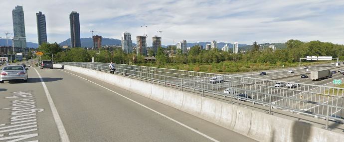
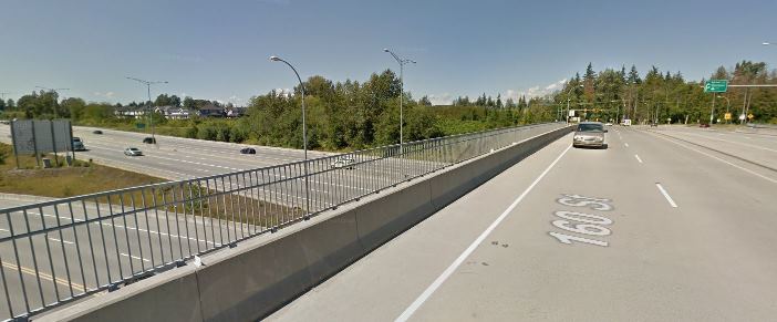
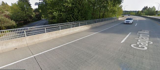
So, taking those things as read, I don’t have to go into the myriad of reasons why the 10-lane bridge plan for the Massey crossing was a bad idea. As I may have mentioned in the past, it was an idea built on a foundation as shaky as Fraser Delta silt. This was obvious during the Environmental Assessment of that lamentable plan. It was found wanting, and required such a contraction of inferred impacts that it literally ignored traffic impacts 100m from the intersection pictured above. It was clear that the only benefit to building it was a political one in a riding held by an independent on the south side of the link. It was no surprise that when the political imperative went away, that half-baked mutli-billion dollar scheme needed to be cancelled.
Here we are two years later. A very-slightly-less-terrible option is being legitimately floated (immersed?), and the same arguments for expanded road capacity are being trotted out like they are long-held truths. Meet the new boss, same as the old boss.
I’m engaging in a bit of wrathful Patsplaining here because I have been banging this drum for a long time, as an advocate for sustainable transportation, as a professional who worked on the Environmental Assessment process of the previous 10-lane bridge proposal, and as an elected official expected to show leadership in my community. This project has been part of my life for almost a decade, and I lament we still have completely failed to address the underlying issues. After all of this time, the political conversation is no more truthful than it was almost a decade ago. Same as it ever was.
The plan to replace the Massey Tunnel with an 8-lane immersed tube is a bad one. Every bit as bad as the 10-lane bridge. Fundamentally wrong for all the same reasons as the bridge, such that they are effectively the same project. There is no defensible reason to oppose the big bridge and now support the big tunnel. To point: it is a massive waste of money that will not solve the problem it is alleged to solve, but will instead take away from efforts to address real crises in our region.
The current tunnel does not meet current seismic codes, that is not a point of debate. Like a shocking amount of our public infrastructure, even life-critical infrastructure, it was not built with a 21st century understanding of seismic risk. There is something very visceral about being one of the unfortunate dozens in the tunnel at the time of a major earthquake that does not have the same effect when we think about the dozens of schools, office buildings, bridges and other structures that are at risk, so this makes a compelling case for doing something. Upgrading or replacing a piece of infrastructure to meet current risk standards should be a priority, no argument there. We may quibble about where to prioritize a tunnel over, say, the 270 schools still on the “to do” list. However, to continue the unfortunate whataboutism of using schools as a comparison, building a much larger facility to accommodate future growth is a different discussion than whether we should replace or fix up a school. Seismic upgrades do not require doubling capacity.
If building more lanes doesn’t fix congestion, you may ask, what does? Experience from around the world tells us there are only two models to significantly reducing road congestion. The Detroit Model (massive economic collapse and depopulation) is probably something only a few fringy cranks want to promote and I want to be clear I disagree with this model for the Lower Mainland. That leaves the Nordic Model: road pricing and serious investment in the alternatives. Invest in rapid expansion of rapid transit, and price the roads to pay for it. One will not work without the other, you need to do both. This combination is the only thing that we know will work, anyone telling you otherwise is lying. No government can claim to be progressive, to be addressing road congestion, or to be committed to climate action unless they are doing these two things.
Why do I care, here in New Westminster, and why should you care? I assert that aside from the Port Mann fiasco, this project will be the most important region-shaping project of our generation. More than SkyTrain to UBC or rapid transit to Fleetwood (and likely at much higher a cost), the expansion of road capacity and entrenchment of a Motordom-oriented development model South of the Fraser will define our region. And the current definition makes us look antiquated and negligent. The tunnel will not only shape our region in a less sustainable way, it will take away limited resources that can must be applied to sustainable transportation approaches if we can ever hope to reach our regional livability goals, or Paris climate targets. But who is going to stand up in our region, and show the leadership needed to push back against this bullshit-driven boondoggle?
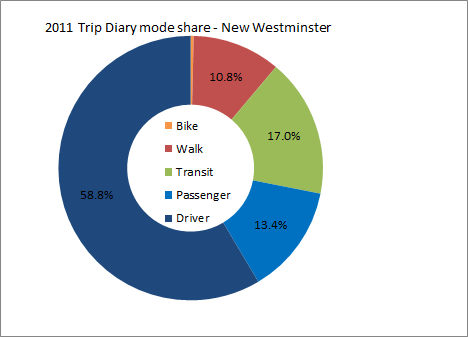
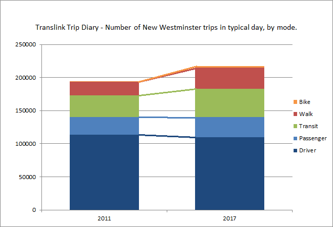
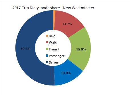 As you can see, the shift is subtle, but in a positive direction if you hate traffic. Our transit rode share went up to 20% and is now the highest in the region (Vancouver’s dropped a bit to 18%) New Westminster is now the City in BC with the highest transit mode share! Our walk share went up to 15% and is still 4th in the region, and our bike mode share doubled from dismal to still pretty bad. Or car mode share, however, dropped from 72% of all trips to 64.5%, and “passengers” went up a little bit in share, suggesting that single occupancy vehicle trips went down. Going from 59% to 51% of driving trips in 6 years is (a 14% decrease) is a really positive sign for the livability of our community.