Vacation

I took a vacation. After a busy but very rewarding year with too much work, a too-stuffed schedule, and too little recreation time, it was good to get away for a couple of weeks and chill.

Of course, I read some books about urban planning (reviews soon, if I get time) and spent a lot of time looking at the urban realm while tracing the career path of Peter Stuyvesant. Here are three thoughts.

1.City Bikes are cool.

This is New York’s bike-sharing program, and while spending an unseasonably warm Christmas in Brooklyn, we had an opportunity to spin around on the almost-ubiquitous blue bikes.

vac3

The bikes themselves are sturdy Dutch-style upright bikes with full fenders, enclosed chains (no grease to worry about), simple but effective three-speed internal hubs, drum(!) brakes, and hub-generator powered lights. Tough? The bikes are (to paraphrase Neal Stephenson) “built as if the senseless dynamiting of [Citybikes] had been a serious problem at some time in the past”. They are pretty much a perfect balance between bulletproof and efficient.

There are many options to pay, from paying for a single ride to buying an annual pass. We bought a couple of 24-hour passes for $10 each. This gave us unlimited access for 30-minute rides. We were able to ride from our apartment in Bedford-Stuy to Barclay Centre, then from Braclay to downtown Brooklyn. Dropping bikes at a convenient station (you are never more than a 5-minute ride from a station within the service area), we walked across the Brooklyn Bridge, wandered around a bit in Manhattan, picked up a couple of bikes in Little Italy, rode across the Williamsburg Bridge, dropped bikes and visited a microbrewery, etc., etc.

Actually, bulletproof and efficient pretty accurately describes the entire system. The kiosks and payment process is simple to use, and features a little digital map you can scroll around to navigate your neighbourhood, the on-line app will guide you to the nearest station (if your 30 minutes are running out), and there are very few surprises.

vac2

Is the system successful? 10 Million individual rides in 2015, and ongoing expansion plans to reach 12,000 bikes and 700 stations by 2017. Before anyone talks to me about my helmetless pictures above (Hi Karon!), there is no helmet law in New York, and with literally tens of millions of rides since its inception 2013, there has never been a fatality or a serious injury on a City Bike. Looking at NYC’s pedestrian and traffic fatality stats, CityBike may be the safest way to travel in the Big Apple.

Yet, globally, no jurisdiction with a helmet law has successfully launched a bike-share program like Citybikes. Every one has failed, or failed to launch. And I predict Vancouver’s will fail for this very reason.

2. Even in New York, pedestrians are serfs.

Walking Fifth Avenue from Central Park to the Empire State Building is an incredible experience. From the Plaza, past the Library and Rockefeller Center and St. Patrick’s Cathedral, through the (unofficial) centre of world shopping, it is a spectacular combination of sights and sounds and people and shopping and urban buzz. A couple of days after Christmas, I got to share it with tens of thousands of other people.

It got rather more intimate than most would probably like, because all of those people were crowded behind barriers on too-narrow sidewalks as hundreds of police spent their holidays keeping the vast expanses of asphalt between the sidewalks free for the movement of – a couple of dozen cabs and towncars.

vac7

Just look at this photo and look at how the public realm is divided up. 4m sidewalks, 20m of road, and look at where the people are. Overall, New York City is one of the most walkable places on earth, and between the incredibly convenient subway system (although, I noted only about 10% of station were accessible for people with disabilities!), short distances to get any kind of shopping you might want, and a huge reliance on walking as the primary form of transportation – the guy in the town car somehow gets priority to an opulent amount of the public space. It’s bizarre.

3. Aruba may be the Netherlands, but it ain’t Dutch.

We picked Aruba for our vacation because we didn’t want adventure this year, we just wanted to chill on a beach, and according to legend, Aruba’s beaches are amongst the best. A legend I will whole-heartedly confirm.

However, we were also intrigued by Aruba’s Dutch heritage (it is still part of the Kingdom of the Netherlands), and hoped to see a little of the Dutch personality of the island. Unfortunately, aside from ubiquitous Heineken and plenty of young Dutch nationals working the tourist bars and restaurants, there was not a lot of Amsterdam to be found in Aruba. For a small island with incredibly pleasant weather, It was a depressingly car-oriented community. We used the local bus service (inexpensive, predictable, convenient, almost empty) and walked most of the time, where most people used cars, truck, atvs, and motorcycles. The only cyclists we saw were of the lycra-clad sporting type. The pedestrian realm ranged from non-existent up on Malmok where we were staying to downright hostile once you got a block off of the tourist strip in the resort areas.

vac5

Maybe we should try Curacao

4. Vacation notwithstanding, it’s good to be home.

And I am realizing that New Westminster has pretty much all of the assets that Jane Jacobs mentions when talking about vibrant communities, which is a hopeful sign…

Q2Q, again.

This Post is actually an extended response to the comment by Ken, a Quayside resident and community builder, to my previous post about the Q2Q bridge. I thought his comments raised enough issues that I couldn’t do it justice just replying in a comment field!

Thanks Ken,

I will try to address your questions, but recognize that much of what you talk about occurred before my time on Council (so I was not involved in the discussions) and I respect that you have a much more intimate knowledge of the conversation on the Quayside over the last decade than I do.

The project has indeed gone through various iterations in its history, and the initial plans ( here is a link to a report from the time) were to reach 22m of clearance to develop a fixed link that would get adequate clearance that we would not need Navigable Waters permission (read- not specifically need Marine Carriers permission) which required essentially the same height as the Queensborough Bridge. Conceptual drawings were developed based on the site conditions and some baseline engineering, and very preliminary cost estimates prepared. That concept was indeed reviewed by the Port (at that time, the Vancouver Fraser Port Authority) and note they even at the time preferred an upstream (east of the train bridge) location (see page 12 of that report I just linked to). Note also: that report suggests elevators at each end to improve accessibility. This is the concept that first went to public consultation, and concerns were heard about the need for long ramps that would have nonetheless been very steep, the overall height, the fate of the Submarine Park, etc.

The only alternative to all of that height was a swing/bascule bridge. To explore this option, the City asked some engineers to sketch and (very preliminarily) price some alternative concepts, including a bascule and a sidewalk attached to the rail bridge. The City again took these preliminary concepts to public consultation, and the bascule design clearly came up as the preferred approach, even recognizing it was potentially more expensive.

Now that a preferred concept was (hopefully) found, and the Q2Q crossing once again received endorsement from the new Council, it was time to actually pay a little more money to engineers to further develop the preferred concept to a level of detail that would allow screening for Port review. Not enough development for a full review, mind you (that will likely take several hundred thousand more dollars in engineering and environmental consultant fees and will no doubt also result in adjustments of the concept), but enough that it is worth the Port’s time to look at our concept and provide a detailed regulatory screening and provide us a pathway to approval.

That is pretty much where we are right now, and for the third time, this concept is coming to the public for review. The only thing I can guarantee you at this point is that if (and it is still an “if”, despite general Council and public support) this project is completed, it will not look exactly like the drawings you see on the page today. There is much engineering to do, environmental review to perform, and more public discussion to be had. Satisfying the Port’s environmental review will be months once we get to that point, and we can guarantee it will require some design adjustments.

There are also other adjustments I think we need to see based on public feedback this time around. Although I have held my cards close to my chest because I don’t want to prejudice the public consultation, I will admit up front that there are two things in particular I cannot tolerate in the plans as presented at the open house: the 8% ramps simply do not meet modern standards of accessibility; and the closing of the bridge at night is not an acceptable way to treat a piece of public active transportation infrastructure. I’m prepared to accept that we cannot have the Copenhagen-style transportation amenity I would prefer, but I am still hopeful we can find a compromise that provides an accessible, reliable, and attractive transportation connection. We are not there yet. (And please remember, I am only one member of a Council of seven, and I cannot speak for them).

To answer what seems to be your main concern, I don’t know when the Marine Carriers were first consulted on this project, but the Port (who provides the Marine Carriers their authority) were clearly involved from day 1. They preferred an upstream location (now prefer a downstream one) and created the 22m by 100m “window” that led to the original 22m-high bridge concept, and have now led to evaluation of several swing/bascule concepts. Clearly, the City and our engineers have been searching for a creative solution to make what the politicians and public want mesh with the rather strict requirements of those who regulate the river and transportation. But serving those two/three masters is why the City is taking this iterative, slow approach, and why “plans that keep changing” are a sign of progress, not failure.

One thing to think about is that every step of this process costs more than the previous step, and moving backwards costs most of all. As engineering analysis and design gets more detailed, it gets more expensive, so we don’t want to do the detailed work twice. We could have asked for a ready-to-build concept a decade ago, and done enough detailed design that we just needed to pull the trigger and we could have it built within a year, and then taken it to public consultation. But if things are found that don’t work (i.e. the initial 22m height), we have spent a lot on a concept we now need to spend more on to change. Instead, we do feasibility studies, take it to stakeholders, the public, the regulators, and are given feedback. We then develop the concept to get more engineering done, and again have a look at the result and either move forward or change track depending on feedback.

This is a responsible way to plan, design, and pay for a public amenity. It is an iterative process, because as a government, we need to do our best to meet the needs of residents, of taxpayers who are footing the bill, of the regulations at 4 levels of government that have a thousand ways to limit our excesses, and of people who may be impacted by every decision we make.

If a government claims to do three years of stakeholder and public engagement, detailed engineering analysis and business case development, then turn around and deliver to you the exact same proposal they managed to render in a 3D model three years ago when the analysis started, then you know their consultation was bunk.

And I guarantee you, for every person who complains “this project has changed since the public consultation”, there are two who will say “public consultation never changes anything, they are going to ram their idea through regardless of what we say”. Actually, the same person will often say both, completely unaware of the irony. And that is why I appreciate your honest comments Ken, it sounds to me like you are trying to understand, not just complaining. So please provide your comments to the Engineering department and to Mayor and Council, and you will be heard!

Q2Q Compromises

The Q2Q bridge is an important project for New Westminster, and one I support. It is, however, a project with major challenges, and I am glad we are at a stage where the next phase of public consultation is taking place, so we can talk about some of those challenges, and what they mean to the City.

First off, I need to put my comments on the Q2Q into context, in relation to my position on Council.

The Q2Q concept was developed long before I was elected, even before I started to rabble-rouse in the community on transportation topics. However, I have expressed strong support for the project for years, even piping up to challenge some of the past opponents of the concept. I have always believed, and continue to believe, that the Queensborough community needs to have a reliable, safe, and accessible connection to the “mainland” of New Westminster, and that connecting the beautiful waterfront greenways of Queensborough to the Quayside boardwalk will have huge benefits for both communities. When the topic came up during the election, I was quick to say I supported the project and wanted to see it built as soon as possible.

Now that I am on Council, and am (in part) responsible for getting this project done, the brutal reality of the project has set in. The bridge some of us may dream of may not be possible in this location, and the development of palatable compromises is daunting and frustrating at times. It is becoming a lesson for me about the reality of planning for community infrastructure when a local government’s power is so limited.

If someone were to ask me what I wanted to see in a Q2Q bridge, it would look something like this:

Click
(typical, ask an urbanist geek about a design, he takes you to Copenhagen)

The bridge would be approximately the elevation of the boardwalks on either side, fully accessible, would be at least 3m wide, and would have an interesting design aesthetic that creates some regional buzz when it is built. As marine traffic would need to cross, it would have an innovative swing style that was integrated in to the design, and was an eye-catcher such that the 5-minute wait for the boat to cross was not something that irritated you, but intrigued you. It would even have areas over the water where you could sit, have a picnic, drop a fish line in the water, or take photos of crossing trains, passing boats, or overhead eagles. It would also represent an easy connection for people commuting by bikes, people out for a stroll, people pushing kids in a stroller – a seamless connection across the river.

But that ain’t going to happen, because the City doesn’t own the river. Although the North Arm of the Fraser at that location is a significant industrial transportation corridor regulated by the Navigation Protection Act and Port Metro Vancouver. I cannot emphasize enough that the people who make a living moving things up and down the river would much prefer no bridge there at all, and due to the nature of the regulations, the people working the river get the say about what goes in, on, or over the river. If they don’t agree, nothing gets built.

The “they” in the case of the North Arm of the Fraser River are the Council of Marine Carriers. They use the North Arm of the Fraser to move barges, boats, booms, and all sorts of floating things. There are no alternate routes, and their business relies on it, so they are pretty motivated to keep the North Arm accessible.

If you haven’t noticed, the train bridge connecting the Quayside to Queensborough is open most of the time to marine transport, and only swings closed when a train needs to cross the river. This would not be a great situation for the Q2Q bridge if we want it to be a reliable transportation connection that pedestrians and cyclists can rely upon. We need a bridge where the default position is closed (to boats), that only swings open when the boats go by, with a cycle quick enough that it won’t cause major inconvenience for either user group.

For the bridge to operate like this, the Marine Carriers have determined a clearance of 14.5m over the water is required. This would permit enough boats to pass under without opening the bridge that a default-closed position is acceptable to the folks who work on the river. This 14.5m makes for a pretty challenging crossing for cyclists or pedestrians with mobility problems. Hence, we can’t have the bridge we want.

q2qdrawThe question then becomes – how do we get people up to 14.5m? A ramp that meets typical mobility-access standards (i.e. no more than 5% grade – and yes, I am aware and frightened that 8% grades are shown on the rendering) would need to be about 250m long, even longer if we add standard landings at set distances. This would be expensive, and create a long visual intrusion for the Quayside residents next to the bridge. Stairs wrapped around an elevator column would have a much smaller visual impact, and if we can avoid the design mistake that led to a completely unacceptable delay on the Pier Park elevator (yes, we can), the size and scale of that structure is a good estimate of what the bridge landings would look like.

This image is *very* conceptual

I would love to see some creative alternate approaches, and we may see some coming from the engineers we hire to build the bridge. The corkscrew ramps at the southern foot of the Golden Ears Bridge seem very effective to me, and are of the same scale vertically, although I’m not sure we have the footprint area to take the same approach:

geb
…and I have my doubts whether Port Metro Vancouver would allow us to build such a structure over top of the water. It has already been suggested that the structure as proposed would require the highest level of environmental review (“Type D”) which makes it sound like a pedestrian and cyclist bridge will somehow have a bigger environmental risk than a coal terminal or LNG export facility.

You may also have noticed the plans for the bridge shifted from being slightly upstream of the train bridge to slightly below. The upstream side as a little better for the City, as both landings work better, but the downstream was deemed safer for boat traffic. Unfortunately, this means the landing on the Queensborough side is going to be much more complicated (read: expensive) to build.

Alas, we are stuck with what we have. I can complain about an industry group having more power than an elected local government about how our river is used, but as we learned in the Fraser Surrey Docks coal terminal discussions, the Port does not answer to local governments, but to their own mandate, and Sunny Ways are not likely to shift their business model any time soon.

So we will do what we can to build the most accessible, most convenient, and most user friendly bridge within the constraints given us, even if it isn’t as elegant as one we might see in a place like Copenhagen.

(non)-SimCity

The City is having this on-going conversation about housing types. It is part of the consultation process for a new Official Community Plan. If you read this blog you probably care a bit about the future of the City, so you should take part. You can now do that without leaving the comforting warm blue glow of the computer you are looking at right now.

The OCP is a legally-required planning document the City produces, and it is usually updated every decade or so. The City is operating on a 1998 OCP that, despite regular updates and edits over the last 17 years, is getting very long in tooth. The process to update it has been going on for more than a year, and there have been several phases of public consultation, as open houses, as stakeholder meetings, and as special events.

Staff have gone out of their way to try to engage more people in this process so that resultant plan can better reflect the desires of the entire community, not just the easy-to-engage groups that are usually over represented in your regular City Open House. Now they have developed a new engagement tool, so you can sit at home on your computer or tablet and provide some useful insight to the process.

It comes at a time when the OCP is looking at housing types, and addresses what some have identified as a significant problem in New Westminster: we have a lot of apartments and an adequate supply of single family detached (SFD) homes; we have very little of the in-between housing types. Townhomes, row homes, du-, tri- and quad-riplex designs, and carriage/laneway housing. With the average SFD in New West selling over $800,000, young and growing families are running out of affordable options in our City, and it is the young, growing families that we need to sustain our community, our livability, and our community in the coming decades. If they leave (or are forced out by lack of flexible housing options), then our city will change in a way that few will like.

So the question to be asked right now is: How do those housing types fit in our community? Are there places this type of “infill density” makes sense, and places where it doesn’t? you can help answer this question by taking this on-line survey. But before you do, maybe I can explain a little more about how the survey works, and what you are being asked. So click this link, open a second window, and I’ll walk you through it.

When you open the survey, you can see there are 5 “pages”, and you are on Page 1, marked by a checkmark. As you go through each page, its page number will become a checkmark, so you can follow your progress.1

Page 1 is just an intro with some factoids on it, and if you hit the “begin” button, it throws you to Page 2:2Here is where various housing forms are shown, divided up into three categories: Low, Moderate, and High Infill. In each of those three categories, there are examples of housing types, (4,3,and 2, respectively). For each of those 9 types, you can select what you think about it (from strongly dislike to strongly like, with “neutral” in the middle). You can also provide some comments for each by hitting the “optional comment” section at the bottom. You might have a specific concern about the function of any one type, or talk about the measures that would need to be in place to make that form work for you.

Not sure what these housing types really look like? The City has provided a couple of walking tour maps, one of Queensborough, another of North Vancouver, where some of these housing types are already built. You can print them off and go take a look, or just go into Google Maps and Google Streetview and have a look around. We live in the future.   

If you provide at least “like” levels for 50% or more of the housing types, you get your check mark and can move on to Part 3:3This page gives you a map of the 1998 OCP (which you can zoom into and look around), and provides you three “Scenarios” for a new OCP. None of these scenarios are necessarily part of a final OCP, but they are models used to gauge opinion and each address different neighbourhoods differently. At the roughest form, Scenario 1 would provide little more growth than we have today, Scenario 2 would provide more opportunities around transportation corridors especially, and Scenario 3 would provide the most opportunity to diversify our housing types, spreading the potential growth around a little more.

You can zoom in and scan around the Three Scenarios, provide a simple 1-5 star rating, and provide optional comments on what you like or don’t like about each Scenario. If you open the Legend, you will see the shades of beige reflect the “Low-Moderate-High” infill that was discussed on the earlier page, and that is where the detail really hits the ground here.

It is important looking at this to remember, if a neighbourhood or street are zoned for “medium infill”, that in no way means every house on that street is going to be knocked down and replaced with a triplex or row homes. Development simply doesn’t happen like that. Houses belong to individual homeowners, the City cannot tell them to knock their house down and replace it. Looking at the existing OCP from 1998 (The “current scenario” map), there are many areas where higher density is permitted than currently exists. For example, the extensive “RL/RM” medium-density area around the 22nd Street SkyTrain station is still single family homes 18 years after that OCP was adopted. Changes permitted on a lot-by-lot basis on an OCP ware not changes required by an OCP on a neighbourhood basis, and with growth occurring at between1-5% annually, these changes are very gradual. This is why we need to look decades ahead in these plans.

So poke around those three scenarios, see what you like or don’t, add your opinions, and give them some “stars”. This earns you a check mark, and lets you move onto Page 4:4Here, you can provide your own plan for how the City should grow. Starting with a blank map of the City (if you use the little pull-down menu that says “City Wide”, it will zoom to specific neighbourhoods). You can drag-and-drop any of the square tabs from the top row, from “Status Quo” up through density to “High Rise”, and drop in on a block in your map. Kind of like SimCity but less immediate feedback. You can also add comments on any block if you wish:4b

You can be creative about what you think the shape of New Westminster should be, recognizing that you are not looking at tomorrow, but 20-30 years in the future. Once you have dropped a few pieces, you earn your checkmark and move on:5

Here, the survey collects a bit of demographic data. It is simple, and anonymous, but helps with understanding what groups are being reached with this tool, and which ones are not. You can provide an e-mail to receive updates (if you want), and add any extra comments. And you are done.

So this Christmas time, you are sitting around with the family, tryped out on tryptophan, presents are unwrapped, log in the fireplace, and it is a few days before the New Years College Football black hole opens up and consumes you whole, spend a half hour playing working on the computer and providing the City the data it needs to make the OCP vision fit your vision.

Merry Christmas! See you in 2016.

Long Span

A short post on what could soon be the longest bridge span in Canada.

There is much to say on this boondoggle (there, I put it out there right up front so you know how I feel about this plan) and the pretend “business case” presented to defend it. I am sure I will be writing something more lengthy and detailed in the coming weeks, but I need to end one line of discussion immediately, so this short note.

In discussing this project, the strongest proponents and the more flaccid skeptics (unfortunately, I don’t know in which of those camps to include the Province’s official opposition), are quick to say “well, something has to be done about the traffic there!” which to most seems like justification enough to spend $3.5 Billion on a solution right out of 1950. The Minister of Speeding even invoked his 1950s predecessor Phil “Air pollution is the smell of money” Gaglardi, calling anyone who doubted a 1950’s solution to a 2015 problem a “naysayer”, like that is the natural antonym to his self-description as a capital-V “Visionary”.

So if we all agree that “something has to be done about the traffic there” (and if we choose to ignore that “the traffic there” has been steadily decreasing for a decade), perhaps we should have a meaningful discussion about what the options are to address that traffic problem. Right off the bat, however, the most ignored point is that we don’t need to get rid of all of the traffic to fix the traffic problem. We only need to get rid of a little bit of the traffic.

Let me explain. But first, we need to ignore this graphic in the Project Definition Report:

ignore

…because it comes without proper citation to its source, and appears to reflect some imaginary projection of what the actual traffic counts in the tunnel are. I say this, because the Ministry helpfully provides actual traffic counts in this document, and as Station P-16-4NS is the counter that measures the number of vehicles going through the tunnel, here is the most recent data:

p164ns

Congestion occurs somewhere around 1,500 – 1,600 vehicles per hour per lane. That’s just one of those numbers transportation geeks keep in the back of their mind when reviewing this stuff. Note that the tunnel has a counter-flow lane, so peak travel is carried on three lanes. The two big peaks flatline just over 1,500 x 3 for about two hours every morning and two hours every evening. At the same time, the single-lane against-peak flow flatlines at about the carrying capacity of the reduced lane count, also causing congestion until the counter-flows can re-open to give a little relief. The tunnel is at capacity during the rush, which is why traffic is reducing on this route, not going up.

Those peaks and flatlines are important, because those are the natural limits of the system, stay a few hundred cars below that, and you have the carrying capacity of the bridge, and (barring accidents and the such, but let’s not go there now) you have a system working at optimum. Looking at the data, that optimum for the system only requires removing about 10-15% of the traffic.

These pie charts from the same report demonstrate how easy it would be to do that:

type1

type2

type3

type4

SOV? Single Occupant Vehicle. A car with one person in it. Anywhere between 65% and 84% of the vehicles driving through the bridge. Add the 2OV (Two Occupant Vehicle), and you realize that the problem at the tunnel is not “goods movement”, as trucks are only on average about 5% of the traffic. Also notice transit vehicles are 1% of the traffic on the tunnel. Despite that 1%, we also learn from the consultation documents that up to a quarter of the people travelling through the tunnel are in that 1% of the traffic:

transittunnel

So how can we reduce the traffic in the tunnel by the required 15%? Get a few of the people in those SOVs into transit. Not all of them (and that is the false dichotomy argument we must avoid), but just a few of them. I’m not even suggesting that tunnel traffic see a radical mode shift, just one in line with transportation patterns north of the Fraser. To do this you need to provide more and better transit service, because to get people out of their cars, you need to give people viable and reliable alternatives. Even the incredibly sub-par overcrowded, under-scheduled, and poorly-connected transit service through the current tunnel moves up to a quarter of the people who go through the tube. Imagine what would happen if it was rapid bus, or light rail…

Alternately, if funding is a problem, you could also do the only thing ever proven to reduce traffic congestion in urban areas: put a price on the road. No need to build a new bridge if you put a small toll on the existing tunnel. That very effectively reduced traffic on the Port Mann Bridge corridor. Then you could use that toll to fix the safety issues at each end and upgrade the 5o-year-old mechanical systems, which by all accounts is an order of magnitude less money than the new bridge would cost.

Of course, to “solve the problem”, any rational transportation planner would suggest the Government do both. This is why the Mayors of the region, who have been grappling with a failing transportation system (and the provincial government’s reluctance to fix it) for a decade now, recognize that the Massey Replacement is not solving any problems. They rightly point out that it will both create larger problems, and take billions of dollars away from the alternative solutions that *can* fix the problem.

Wow. This short note sure got long, what with the graphs and such. Sorry, I will sum up.

Yeah, maybe somebody has to do something about the traffic here, but the solution being offered is far from “Visionary”. Instead, it is an expensive kludge being offered by people who lack the imagination and courage (two characteristics that define true Visionaries) to address a problem in a creative new way, instead relying on the ghost of a 1950s ideology.

These people

thesetwo

Look at those two on my right. They aren’t just one of the cutest couples known to history, they are a big part of the recent history of New Westminster. I’m celebrating them here today because they just got on a plane, headed for Montreal and a new home, a new adventure, and a new community.

Will Tomkinson was born and raised in New West, in a heritage home on 1st street across from Queens Park. He is variously third- or fourth-generation or something the other, which makes him “Old New West”, and he has the sartorial style, baritone singing voice, and respect for traditions to fit the stereotype. Briana is a transplant to New West, with new-fangled ideas about creating local connections through social media and social justice, rarely hearing a new idea she didn’t want to throw up a flag pole, just to see who salutes. They met in Douglas College and eventually fell in enough love to start building a homestead in the West End of New Westminster. They started raising a gaggle of free-range kids, and started blogging about being a young family in New Westminster.

It was only a few years ago, but I cannot remember for certain when I first met them, or when I became aware of Tenth to the Fraser, or which came first. However, it must have been around the 2008 Municipal Elections when the Tomkinsons’ hyper-local Blog became part of my usual web surfing routine. I vaguely remember helping run an all-candidates event at Douglas College in what must have been the May 2009 Provincial election with Will and Briana (I seem to remember pulling audience-member’s questions out of Will’s fedora, but my memory is more photogenic than photographic), so we must have been friends by then.

What Briana and Will (and Will’s sister Jocelyn, and later Jen Arbo) did with 10ttF was create a social media nexus in New Westminster. It was a general-purpose Blog back when Blogs were the cool new thing. Instead of just being about them, they covered events in the city, politics, business reviews, and general interest stories about being a young family in a growing and changing community. And as with all really effective social media, it created digital connections that soon became human connections. They introduced us to, and induced us to support, new local businesses like Re-Up BBQ and new social enterprises like the Royal City Farmers Market. 10ttF was a glue that brought people together without the commitment of a club or the constraints of common interest, and their comments section was often where conversation took place amongst that in-between generation of young professionals and young families who found Letters to the Editor a little too quaint, and those who were too profane or silly to be committed to newsprint.

Through 10ttF, I was encouraged to start my own Blog, first on environmental issues as GreenNewWest (I was the President of the New Westminster Environmental Partners and an Environmental Scientist- “write what you know”, they say), then as NWimby, as my interests expanded. It was through 10ttF that I first met Jen Arbo, who once told me I had to do this Twitter thing (much to James Crosty’s chagrin), and who eventually became a huge supporter during my campaign for City Councillor. It was through 10ttF that I was encouraged to get involved on City advisory committees and other volunteer work around town, which was one part of what led to my Citizen of the Year nomination. I have a lot for which to personally thank Will and Briana.

So now the Tomkinsons are pulling up stakes and relocating to la belle province. A great job opportunity, and a chance to escape a bit from the frenetic property-value-defined lifestyle of the West Coast, they are going to raise that gaggle of kids in a wooded semi-rural area with actual seasons and where half the people speak an entire other language. Can’t say I’m not a little jealous for the adventure those kids are going to have. But even as they have been recently pulling back from their central-organizer roles in New West due to work commitments, an expanding family, and some other pressures, we will now truly feel their absence at the next New Westminster Scotch Appreciation Society meeting, at the next NEXT-NW soirée, at the next Brew Westminster kettle boil, when we need a line on a sweet artisanal axe.

The legacy they have created, however, will go on. Tenth to the Fraser has a new owner (the ubiquitous and omniscient Jen Arbo), and pieces are being put into place to create a new look and a new vibe to appeal to that larger group of digitally-connected people who are increasingly making New Westminster their home. The many connections Briana and Will made remain strong: on line, at Beer Friday, or just down at the River Market at a Saturday where we somehow find there is always someone to talk to, someone who is so familiar around New West as you consider them part of the furniture, but you can’t quite remember when you first met them.

Thank you Will and Briana. You are good friends, and great citizens, and you made New Westminster a better place for those you are leaving behind. We’ll see you again soon.

Council – Dec 7, 2015

Another week, another very late Council report. Sorry, but Theresa McManus sits through our sometimes interminable meetings, and I like when she gets the scoops! No, actually, in reality I have been busy with events, some political, some Christmassy, all much fun (except for the public meeting from which I was given the bum’s rush, but that is another story for another time!)

The final Council Meeting of 2015 began with Council passing the following items on Consent without discussion:

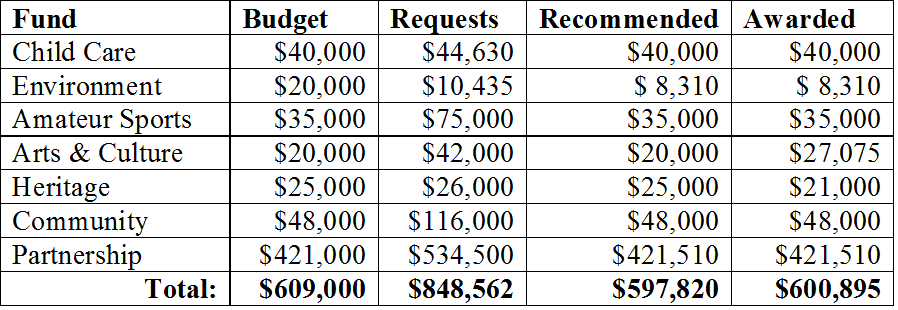
Preamble: many topics this week are around the various Community Grants the City awards to various groups in New Westminster for various purposes. All of these grant funds exist within a Terms of Reference, and a pre-determined budget. Each grant fund has its own committee that recommends to Council how the budget should be allocated, based on how their application meets the term of reference provided to the Committee by Council.

That said, ultimately, the decision on funding resides with Council. I really appreciate the work these committees do, and any changes that Council make to the recommended grant allocations represents either a failure of Council to set a Terms that properly reflect their desires, or an introduction of new information by Council that the Committee did not have access to (i.e. that the entire Grants budget was not awarded).

2016 Child Care Grant Committee Recommendations
This Grant has a $40,000 annual budget, and just under $40,000 was granted (of $44,630 requested) to support the needs of 295 children. Of course, that is not a good measure, because the grants are not for operations, but for capital projects that enhance childcare spaces and create an ongoing legacy, potentially helping thousands of kids in non-for-profit daycare across the City.

2016 Environmental Grant Program Recommendations
Only $8,310 was granted this year from $10,435 in requests, and out of a budget of $20,000. Let this be a message to burgeoning environmental groups or those with an idea to improve the City’s sustainability – there is more grant money available next year!

Information Access Principles and Guidelines
Move recommendation

Recruitment 2016: Appointment of Chairs to 2016 Advisory Bodies
This is the assignment of Committees for the members of Council. Not much has changed from last year. I chair two committees (ACTBIPed, Access Ability Advisory), Co-chair one (Environment Advisory), serve as Council representative on one (Youth Advisory), and am a member of three Task Forces (Public Engagement, Transportation, and Canada Games Pool Replacement).

Community Heritage Commission Amendment Bylaw No. 7808, 2015
The Heritage Commission is a Council advisory committee. This recommendation is to adjust the terms of reference such that the two-year terms are staggered between two groups of appointees, to create some continuity. An easy thing to agree to.

Arts Commission Amendment Bylaw No. 7809, 2015
This is the same change as with the Heritage Commission, staggering two-year terms to create more continuity.

Information Access Principles and Guidelines
After some public consultation ,we are moving forward with developing policy improvements to how the city manages our Freedom of Information files. The City is moving increasingly towards easier access and more openness of our data, which is a good thing.

Tenant Relocation Policy
This report came out of a request I made a few months ago for Staff to update Council on how well we are protecting the affordability and accessibility of rental housing in New Westminster. We have a Secured Market Rental Housing Policy which is helping us get more rental housing built as we battle against regional shortages. We also have an Affordable Housing Strategy that works to develop supported affordable housing options. However, we have a vacancy rate of about 1.3% in market rental housing, and as new rental buildings replace some of our aging rental stock, the rents increase significantly, with average rent for a building built after 2000 almost double that for a building built before 1980.

The challenges here are plenty. Rental stock must periodically be replaced, as aging buildings do not provide the safety, the energy efficiency, or the durability of newer buildings, and become more expensive to maintain at the same time as their value to renters becomes reduced. Still, there are instances where people live in the same rental unit for a decade or longer and truly establish homes in rental buildings. Forced removal, by renovation, by development, by demolition, is incredibly disruptive to their lives. Seniors are the most vulnerable, although young families with limited incomes suffer from stress as well.

I would like an evaluation of whether the policy can provide higher levels of protection to longer-term tenants, and what the implications are if we include this in a policy… will we disincentivize longer-term rentals, or are protections in the existing Residential Tenancy Act enough to prevent that kind of blow-back in policy?

I also want to have a little better understanding about how the tenant relocation and eviction process would dovetail with a typical Rezoning or HRA, where the review process and Public Hearings and bylaw implementation can take 6 months or a year. Does that get included in notice, and how to we sensitively facilitate the communications between landlord and renter over what can be a year-long process?

I see this policy as supporting an updated tenant relocation strategy, similar to those adopted in Vancouver and North Vancouver, but recognizing some of the unique characteristics of New Westminster, where we have a large stock of aging rental buildings, and where much of other rental stock is found in non-purpose rental and less formal arrangements like secondary suites. This is fundamental to the livability and affordability of our City, and am happy staff is continuing this work and bringing back a developed policy to Council early in the New Year.

Zoning Amendment Bylaw No. 7781, 2015 to Zoning Bylaw 6680, 2001
to Permit Commercial Storage Lockers in the C-4C Zoning District

There are a set of storage lockers in Plaza 88 near the loading bay on 8th Street, which have turned out to be not useful for the commercial or residential users of the building complex. The owner of the building would like to convert them to commercial storage units, which requires an amendment to the Zoning Bylaw to permit that type of commercial operation.

Animal Shelter and Tow Yard Facility – Task Force Recommendations
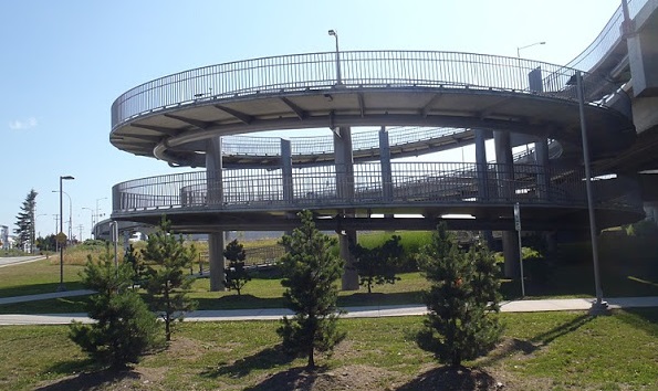
The City is building a new Animal Shelter, and is integrating it with a move of our tow yard to create a single civic facility in Queensborough under the Queensborough Bridge. This is part of our long-term strategic plan, and will be paid for by some strategic land sales as part of our long-term capital plan. The task force has been working on this for quite some time, I’m glad to see the City moving forward on their recommendations.

The meeting then proceeded with an Opportunity to Be Heard:

DVP No. 601 for 109 Third Ave
This Development Variance Permit is required to allow a resident to pave a thin strip of their land so that there is smooth asphalt between their three-car garage and the adjacent alley (which is, like many alleys in New Westminster, a named street, in this case, Emory Street). The zoning only allows paved driveways to be certain widths, and this is technically a “driveway” that exceeds that width, although it is only a foot or so long.

We received one piece of correspondence supporting the DVP, and no-one came to speak against it. Council moved to support the DVP.

We then had a presentation from folks at Fraser Health to talk about the first stages of construction work at RCH, which includes the moving of the Helipad. Following this lengthy discussion, we wanted to delay the conversation about Grants until after the Public Delegations, we launched into other parts of the agenda including:

Recruitment 2016: Library Board Appointments
This is an approval of the recommended new members of the Library Board. Welcome, new volunteers.

DNA funding
This is a follow up to a recent federal decision to download the funding for DNA analysis to local police forces, and the unwillingness of the Provincial Government to step up and fill the gap. Police costs come right out of your property taxes folks, and this will add to that burden.

Commercial Storage Lockers Zoning Amendment Bylaw No. 7781, 2015
As discussed above, this Bylaw received two readings.

Community Heritage Commission Amendment Bylaw No. 7808, 2015
As discussed above, this Bylaw received three readings.

Arts and Commission Amendment Bylaw No. 7809, 2015
As discussed above, this Bylaw received three readings.

Inter-Municipal Business License Agreement Bylaw No. 7794, 2015 and
Inter-Municipal Business License Agreement Bylaw No. 7795, 2015

As discussed November 30, these Bylaws were Adopted. It is now the Law of the Land, please adjust your behavior appropriately.

Demolition Waste and Recyclable Materials Management Bylaw No. 7660, 2014
As discussed November 30, these Bylaws were Adopted. It is now the Law of the Land, please adjust your behavior appropriately.

After a short recess and some Public Delegations, we continued covering items removed from the consent agenda, which again launched us into talking about Grants.

2016 Amateur Sport Fund Committee Grant Recommendations
This grant is totally covered by two endowment funds, one from the Canada Games (1973!) and one from the Casino. More than $75,000 was requested, and the full allotment of $35,000 was awarded. This works out to about $10 per athlete for 3,500 amateur athletes over 10 different sports.

2016 Arts & Culture Grant Recommendations
I needed to remove myself from some of this discussion because @MsNWimby is the treasurer of the Arts Council, and filled out a lot of grant forms for them. Regardless, there was $42,000 requested from a fund of $20,000. After some compelling delegations Council decided to expand the granting envelope here and add $4,500 for the Royal City Musical Theatre request, and $2,575 for the New Westminster Symphony request.

2016 Heritage Grant Program Committee Recommendations
This grant allocation is $25,000, and we had $26,000 in requests. Uniquely, one organization was granted $4,000 more than they requested, which rubbed a couple of Councillors the wrong way (including me). So instead of granting them the $14,000 recommended, we dialed that back to $10,000. In total, we ended up granting $21,000.

2016 Community Grant Recommendations
There as a budget of $48,000, all awarded, from requests totaling almost $116,000. The recommendation was followed.

2016 City Partnership Grants
Again, there were some Arts Council requests here, which means I had to remove myself from that part of the discussion. This is the big one – $421,510 was awarded from a budget of $421,000, and there was $534,500 in requests. Some are multi-year agreements.

So after all is said and done, we came in a little under budget on Grants, but still awarded more than $600,000.

table

At that point, the meeting was all over but the singing. We Wish you a Merry Christmas, indeed.

Council – Nov. 30, 2015

The council meeting on November 30 was a little different in format, and it appears we are still working out some bugs of the post-Committee of the Whole era for New West Council. Part of the reason for the change of formats was to provide more time for open workshop-type discussions where we can dig into larger issues though a public discussion, the other was to try to push more of our day-to-day business discussion into the evening meeting, instead of doing it as a Committee of the Whole.

This week’s agenda had such an Open Workshop that ended up looking very much like a committee of the Whole meeting, including items passed on consent – not really the purpose of a workshop. We also had a remarkably light agenda including the Public Hearing and Workshop materials, so I may as well report on what talked about at all three meetings.

Workshop:

The New Media Gallery First Year
I’m not afraid to admit I am a big fan of the New Media Gallery, although I was at times wondering how it was doing as far as crowd-draw and regional impacts. Looking at the report, it is clear the answer is very good. Compared to any other regional publically-run Art Gallery (with the exception of the Vancouver Art Gallery), the NMG is pulling big numbers, and operating on a lean budget. The fact we are pulling in internationally-famous artists when the gallery is so new and limited in budget is a real testament to the knowledge and talent of Sarah and Gordon, our exceptional directors.

You should take the time to go to the NMG, it is free to enjoy for everyone, and open to all ages. The current show “the Scary”, and despite its title, looks pretty appropriate for all ages to me. I find a great way to enjoy the NMG pieces are to go in without a guide, and just sit and try to figure out what is going on. Some pieces seem very straight-forward, others completely baffling. After spending some time setting your own notions, you can have the host provide you a walk-around tour, which will usually change what you thought was straight-forward, and open up some of the things that didn’t make sense to you at first pass. It is a fun way to spend an hour opening up your mind. I’m really happy it is so successful. The fact it often challenges what I interpret as “Art” leads to the next topic we discussed in Workshop…

Public Art Workshop
This report brought us into a discussion about how the City’s Public Art program operates, and more specifically, what the role of the Public Art Advisory Committee, our professional Cultural Services Staff, a Public art Selection jury, and Council play in determining how our public art budget is set up.

In earlier discussions, I think I have made my position pretty clear on this (and I am digging deep into personal opinion here, speaking only for myself, and willing to hear counter-arguments). I think Council should approve themes, ideas, concepts, and budgets, but we should not be the final say on which pieces of Public Art are selected. I was not elected for my art criticism skills, and art, by its very nature, should challenge what we think we understand about aesthetics, about communication, and about community. To have 7 politicians look at something created by a professional and curated by a jury of professionals who were presumably provided clear conceptual guidance, and have those Council members “I don’t like it” is to undermine the professionalism of those persons so charged, and to have Council say “…therefore we won’t have it” opens the doors to all kinds of censorship and other issues. Sometime good governance is being able to step back and let people do their jobs.

I want our Public Art to be interesting, challenging, and iconic. To get there, it sometimes has to push the community out of its comfort zone. If given a choice between two pieces, one that Council unanimously endorsed, and one that Council turned down 4 votes to three, I can tell you which of the two would generate more interesting conversations and push the discussion of artistic expression into the daily conversation. It would be a shame if this or a future council, were to recommend against something for fear of facing some negative public reaction. Ironically, the best way for us politicians to avoid being in that situation is to rely on our professional staff and the jury of art professionals, with the guidance of our Public Art Advisory Committee, to determine what best fits the needs of the piece, the location, or the concept.

I have to admit, the WOW piece looks a lot better in context than it does is photos (or it did as concept drawings), and although I could not envision it, I supported the process that got the City to approving it over the last year or two, and I appreciate the positive and negative feedback I have received since it was installed. It makes a statement, it challenges our idea of aesthetics, and it created a new visual icon on our waterfront. It works.

Temporary Use Permit for Extreme Weather Response
There is an Emergency Shelter set up in Downtown New Westminster which is activated when the weather gets such that it seriously threatens the lives of people who are living outdoors (extreme cold, snow, protracted heavy rain), The permit for this site must be renewed every three years, and Council moved to renew the license.

Councillor Puchmayr further raised the issue that the hours of the shelter do not coincide with other social services in town, and asking about the potential to expand shelter hours so that in the worst of conditions, people at risk don’t have to spend a few hours every morning with no-where to go, exposing them to potentially hazardous conditions. Of course, funding and programs are stretched, but we need to find these opportunities to improve what services we provide.

There were also a couple of items that we, paradoxically, passed by Consent as part of the Workshop:

Anvil Centre Capital Budget Update
This is an administrative shuffling of budget amounts. There were several things at the Anvil fit-out that cost more than expected (AV system installations, LEED certification, etc.) and to pay for them, several other things (Installation of corridor, dishwasher upgrades, storage space modifications, etc.) were put off until future capital budget savings or a new allocation of capital funds.

Youth Advisory Committee Amendment to TOR
We agreed to adjust the Terms of Reference for the Youth Advisory Committee to include one more person, a returning member of last year’s YAC who made great contributions in the community and would make a great mentor for the new YAC members.

The evening’s meeting began with an Opportunity to be Heard on the topic of ne Inter-Municipal Business License Agreement. I mentioned this in a earlier report, where were are working with adjacent Cities to align our business licensing for building trades and contractors, such that it is easier for these businesses to work across municipal boundaries, but each City’s business license costs are still covered.

No one corresponded with the City on this issue, and no-one came to council to delegate on the topic, so we referred the two enabling Bylaws to Council for Third Reading.

The Public Hearing began at 6:00 sharp, with a single project up for discussion:

This is a townhouse development in Queensborough at the Corner of Boyd and Stanley Streets. This is essentially the western end of the higher-density part of the Queensborough west of Boyd Street, and is in compliance with the larger Queensborough Community Plan. It will have 80 townhouses, all 2- and 3-bedroom, averaging over 1,200 square feet each, with some green space in the block, special design considerations (double drywall, higher-buffering windows) to reduce the impact of nose from the light industrial area to the North (which, in the case of the way the Port manages its “industrial land”, means a truck warehouse, which will not generate a lot of noise other than truck traffic), and an established buffer between the buildings and the adjacent Riparian Management Area protected watercourse.

The Community Plan supports it, the Design Panel supports it, the Advisory Planning Commission supports it, the Queensborough Neighborhood Association supports it, the Port opposes it, and no-one else wrote or came to Council to speak about it, so I have no reason to oppose this project.

The Regular Meeting began right after the Public Hearing, and began with the Zoning Amendment Bylaw coming out of that Public Hearing:

Zoning Amendment Bylaw No. 7796, 2015
As mentioned above, this is a townhouse development in Queensborough at the Corner of Boyd and Stanley Streets, and Council passed Third Reading of the Bylaw.

This was followed up by several other Bylaws:

Inter-Municipal Business Licence Agreement Bylaw No. 7794, 2015
Inter-Municipal Business Licence Bylaw Amendment Bylaw No. 7795,
2015.

After referral at today’s Opportunity to be Heard, these Bylaws were given Third Reading.

Delegation Bylaw No. 7176, 2015
As discussed on November 16, This Bylaw was adopted. It is now the Law of the Land, please warn your neighbours and friends.

Development Cost Charge Expenditure Bylaw No. 7797, 2015
As discussed on November 16, this Bylaw was adopted. It is now the Law of the Land, please warn your neighbours and friends.

Engineering User Fees and Rates Amendment Bylaw No. 7798, 2015
As discussed on November 2, this Bylaw was adopted. It is now the Law of the Land, please warn your neighbours and friends.

Which bring to the end a very short meeting of New Westminster council.

Inconvenient Thesis

I’ve mentioned the Gish Gallop before, in how it is used by the disingenuous to cast doubt on the scientific certainty that the observed recent increase in warming of the planet is caused by the introduction of fossil carbon to the atmosphere by human activity. I even opined that the Gish Gallop is the mark of someone who knows they are being disingenuous, because its use knowingly belies intelligent discussion of the topic or useful exchange of ideas.

I have also written several retorts and taken pot-shots at Tom Fletcher, because he is, in my opinion, the most ignorant, belligerent, lazy, and cynical columnist claiming the mantle of journalism in British Columbia today (and there is an ongoing battle for that low ground) while being unexplainably ubiquitous in small town media across BC. Misinformed and regressive opinions are one thing, but when combined with terrible rhetorical skills and piss-poor writing, it is pretty unforgivable that Fletcher still draws pay from the ever-shrinking dead tree media. I have not agreed with a P.J. O’Rourke opinion since I was an 18-year old, hemped up on hormones and car magazines and the smart-ass-conservative-white-dude-certainty they reinforce, but at least O’Rourke can turn a phrase and make me laugh while I disagree with him. Fletcher just makes me weep for a societal system that gives him a forum.

One thing they teach you in high school English class (and sorry to get all academic elitist here) is that an essay needs to have a thesis – in the OED sense of “a statement that is put forward as a premise to be maintained or proved”. In other words, before you sit down to write something, you need to understand what you are trying to say. For example, the thesis of this blog post started out as my strongly felt personal opinion that:

“Tom Fletcher is a hack journalist whose opinions are ignorant to the point of insulting his readership, whose writing skills are subpar, and whose continued employment as a columnist by Black Press represents an injustice to the many skilled and determined journalists currently suffering underemployment from the collapse of traditional media model, while also supporting the theory that this collapse is a result of wounds self-inflicted by the very media platforms that are suffering most from the collapse”.

Although, in the interest of brevity, I might have to reduce the scope of this thesis to the first 5 words.

The piece of evidence that led me to write an opinion essay on this thesis is Fletcher’s most recent Black Press missive, entitled “Inconvenient truths of climate change”. I challenge you to put a single-sentence thesis on this column that is supported by the column. Is Fletcher arguing that polar bears are fine, and therefore the climate is not changing? Is he arguing that the COP21 talks are doomed to failure, or that, because of the “religious zeal” of climate change profiteers, they should be doomed to failure? Is he arguing that BC was wrong to put in a carbon tax and reduce emissions while growing the economy, or that BC were previously leaders who are now failing because the economy is growing despite the existence of a carbon tax? Or is he arguing that Barack Obama’s failure to meet some of the aspirations he expressed at his inauguration should be a lesson to Justin Trudeau to just give up?

The column comes across as a Gish Gallop of disconnected factoids bereft of context, leading one to suspect that introducing context to any of the factoids would prove most of them to be less representative of the truth than a typical YouTube video comments stream. By introducing a little context, or at least a coherent narrative, perhaps Fletcher could get the column past the entire “old man sitting on a porch shaking his fist at passing clouds” aesthetic. Although, one could suppose that was the position he was actually aiming for. I can’t imagine his motivations, only marvel at the results.

Large parts of the old media are dying, at least in part because of instant accessibility to a huge variety of new voices and more interesting approaches to content delivery that are simply out-competing the dead tree press for time, for eyeballs, and for advertizing money. Smart companies are adapting to this change and not just taking the same stale product on-line, but are re-investing in quality of content, giving people a reason to look at what they are producing. Other companies are just pushing their old, tired concepts onto digital platforms, hoping that enough flashing lights along the edges will make their tired content seem new, and the pop-up ads will be attractive to the people who pay the bills. In the quest to appear “interactive” they have created unreadable comment forums attached to articles, that soon degrade into nonsensical collections of disconnected uninformed factoids bereft of content or self-recognition, interspersed with cynical drive-by insult-by-implication.

In other words: a typical Tom Fletcher column. They should be treated with the same deference.

Bugs in my compass

I had a slightly different commute schedule last Wednesday, in that I had a morning meeting in one of New Westminster’s western suburbs, and had one of those multi-leg trips to work. Instead of riding my bike or joining my carpool partners, I took the SkyTrain on all three legs.

My transit commuting is irregular enough that FareSavers have been the most logical and economical way to pay. Since the FareSavers have become about as rare as white rhinos, I have been buying tickets at the kiosk, pretty much because that is the pattern I have fallen into. On the first leg of my Wednesday journey, I reflexively bought a 2-zone ticket and although I noticed a few weeks ago that the new tickets are essentially disposable Compass cards, it took me one of those overstuffed train moments of self-realization to ask: why the hell haven’t I bought a Compass Card?

My thinking place
My thinking place

So on the second leg of my journey, after my meeting in that distant western suburb (I like what they’ve done with the place, not sure why anyone would want to live there), I popped for the $6 deposit and a nice float of $60. The number seemed to me prudent: large enough that it will keep me for a little while as I try out these new-fangled ideas, but not so large that I will hate the world when I inevitably lose it. Tap In at Waterfront; all good.

My first problem was at Brighouse. Like many of my cohort, I was riding with earphones, listening to a Skeptic’s Guide to the Universe podcast, and as I left the station and performed my first Tap Out, I was uncertain if I heard a beep. Actually, I heard multiple beeps, as people were tapping in and out all around me, but did MY kiosk beep? I think so, and with people behind me rushing out of the station to the busses, I didn’t want to break momentum to make sure. Even if I did, would Tapping Out twice somehow mess the system up, and count as re-entry? When did I become so old that new technology confuses me? Was it before or after I completely lost touch with popular music? Is Beyonce still a thing?

Fortunately, I can go on-line to see the status of my Compass Card. To do this, you need to set up an account, and aside from the frustratingly archaic, patriarchal and gender-normative mandatory “Mr/Mrs/Ms” data field (really, TransLink? It’s 2015), the interface was easy enough for gramps like me to navigate. I was able to confirm that, sure enough, the Tap Out didn’t take. My card balance showed $55.80, meaning I was charged the FareSaver Rate of $4.20 for a three-zone ride, instead of the $3.15 FareSaver Rate for a 2-zone ride. To fix my Tap Out mistake, I needed to call the 1-800 phone number, which launched me on yet another metaphysical debate about whether that hassle was worth $1.05 of my time.

I go through life like this, folks. It is harrowing.

Being interested in taking the ride to see where it goes, I did nothing. After work I once again hopped on transit, this time Tapping In at Brighouse Station at 5:10pm (90% sure it beeped for me), Tapping Out at waterfront at about 5:45 (70% sure, as the exit from Canada Line at Waterfront is a serious traffic pinch point that I am still certain will be the failure of the entire FalconGate Fiasco), Tapping In again across the lobby at Waterfront (100% sure, as the FalconGate was operating), and Tapping Out again at Columbia Station at about 6:15 (lets put this one at 95%). I made it to my 6:30 meeting at City Hall just in time. Thanks TransLink!

Curious to see how all of this activity showed up on my card, I logged on (after resetting my password, because who remembers those things?) and this is what I get:

Capture

Clearly, Compass is confused, or I really need to work on my tapping skills. My 5:10 Tap In was apparently registered, as it appears to have made the system aware I didn’t tap out, but none of the subsequent taps was registered. Fred Astaire I am not. As far as tracking my movements, we have a 2 for 6 on Taps. I suppose the two Waterfront taps cancel each other out, I’m surprised it didn’t catch me leaving Columbia Station. The good news is:

Capture2

The confusion of my movements has resulted in TransLink charging me for one three-zone trip, and not for the two 2-zone trips I made, so I guess I am $2.10 up on the deal.

I hasten to note this problem is very likely to go away once the FalconGates are fully operational, as it will be pretty much impossible for you to miss a tap-out. The current bugs in the system should probably be expected, and at least there is a method for you to receive a refund in the case you get overcharged.

As an interesting aside, I have two travel options on transit getting from my work to New West. I can take the Canada Line to Waterfront, then SkyTrain to New West, or I can hop on the 410 bus to 22nd Street station then one stop on SkyTrain. Both take almost exactly the same time, one hour station-to-station. I have always chosen the SkyTrain because it is more comfortable than the 410 bus and (traditionally) more reliable as it doesn’t get stuck in the east-west-connector single-occupant-vehicle Stockholm-syndrome traffic-radio-reality-program plebiscite-free fustercluck that our regional transportation system is becoming.

However, now that we are in the Compass world there is another difference:

Capture3

The ride on the bus will cost me $2.10 with my loaded Compass Card, the Train ride $3.15. If I was a daily commuter, that would be a difference of more than $500 a year. This makes me wonder if people will actually engage in this type of “toll avoidance”, trading convenience and comfort for a few dollars a day.