OK, I’ll wade in.
For anyone paying attention locally, the Hyack Festival Association has been embroiled in some sort of internal-strife shit-show for several months now. I commented a bit on the situation back in August, when the information was scarce, and appropriately kept my comments limited to hoping that things get worked out. After all, Hyack’s volunteer force and their link to the public face of the City are important to the community. They have for 40 years maintained many of the traditions that describe New Westminster, and I hate to see babies tossed out with bathwater.
But the bathwater is getting so deep and murky, it is hard to tell if the baby is still in there.
Since my initial comments in August, I have had discussions with many people in the City about Hyack. I have talked to one current Hyack Board member (notably not one who has been commenting in the media), I have talked to both Bart Slotman and James Crosty (both of whom claim to have been drawn into this public conversation reluctantly). I have talked to Executive Directors for other organizations and business people in the City who work with Hyack, and even to a former Hyack staff member. I have not talked to Douglas Smith (I have still never met the man) or Gavin Palmer (we have not been formally introduced). I have also tried to piece things together based on various media reports, letters to the Editor, and social media conversations. I am hardly “inside” this issue in any way (although I am now a Hyack member – more on that below), but I feel I have done everything I can as an “outsider” to gather info and understand the issue as a concerned citizen.
As every conversation I list above was casual, social, and off-the-record, I am not going to quote anyone or put anyone else on a particular side of an issue. Coming out of the closet about their Hyack opinions is up to them. If they choose to speak up or correct me in the public record, I am happy to be corrected on any point of fact. I am also going to assume that everyone writing to the paper or speaking out about this is being truthful, because I have no reason to assume otherwise.
So with those caveats, here is the gist of the situation, as best I can stitch together. There is a battle going on right now for the heart of Hyack – what it is, what it has been, and what it will be in the future. There are essentially two “camps” within Hyack, and if I can paraphrase their positions:
One group has a “steady-as-she-goes” attitude about Hyack. The organization has deep roots and traditions, and it is by respecting these traditions that they have accumulated assets worth more than $1 Million, and have an army of volunteers ready to fill roles in the established routines to keep the ship floating. They have been successful for 40 years, and will continue to be successful if they keep running things the way they have proven works. Careful evolution is preferable to massive changes. This group includes the current President, two remaining Executive members, and a large contingent of ex-Presidents and former Board Members (the “Plaid Coats”). This group also probably represents a plurality of the paid Members of the society.
A second group thinks Hyack needs to makes changes to get with the times. They see some of the traditions of the Hyack Association as dated, and feel that money and volunteer effort could be better spent on updated or refreshed events. They are concerned about the Hyack’s lack of transparency and apparent inability to broaden their appeal to a more diverse community. They see flagging interest in some Hyack events (i.e. the Easter Car Parade) and recent successes on new events to attract an audience and sponsorship money (i.e. Uptown Live), as evidence that they can broaden their appeal and be a more successful festival organizer to the benefit of the entire City. This group includes the (now-former) Executive Director, and (this is the important part) a slim majority of the current Hyack Board.
The conflict arose when the majority of the Board (the second group) supported some updating of the traditions through a new strategic plan, and the Executive and Plaid Coats (the first group) did not agree with that decision. Best I can tell, from that single disagreement on long-term vision of the organization, a lot of bad decisions were made that got us to our current situation.
What is the current situation? Not good:
- The organization is currently without an Executive Director- and seems to be burning through them at a rate that hampers long-term planning and relationship building. Now, back when I worked in retail, there was pretty good staff turnover. Low wages and hard work – that’s the reality of retail. But if I had 4 people I hired for the same manager job and they all quit or were fired after only two years, the owner would be looking at me as the problem, not the people I hire. I’m not saying…. I’m just saying.
- The organization appears to not have a functioning board. If decisions made by a clear majority of the board can be overturned by a minority, or vetoed by a President, then there are serious governance issues that need to be addressed. Not just to make the organization function as intended, but to meet constitutional and legal requirements under the Societies Act.
- The organization may be headed for a bad day in court. The former Executive Director has all but told the media that there will be legal action over his dismissal. We can assume from this he will be arguing for wrongful dismissal, and some of the untoward comments made in the media about alleged reasons for his dismissal probably bring an aspect of defamation into the conversation. I obviously don’t know if there were grounds for dismissal, but the hasty invitation back and negotiation of terms suggests someone received legal advice and the organization may need to dust off their chequebook and write down a lot of zeroes to make this go away, or risk spending a lot of time paying lawyers to go to court.
- The organization is having a problem with sponsors. There have been several news reports of large sponsors distancing themselves from the current imbroglio. Some of them may come back if the confidence in the organization returns (although after making Slotman the villain, and calling for a boycott of Royal City Centre, some bridges might be harder to mend…), and I don’t know how widespread this is, but if three major sponsors are publicly announcing their concern, you can bet there are many more quietly stepping back. Continued strife, lack of direction, and potential court battles will do nothing to encourage any of them to come rushing back any time soon.
- The organization is eating itself by not dealing with the situation. The roots of this problem go back at least to the strategic plan in the spring, and the current situation came to a head in July with the firing of Douglas Smith. We are now in October, and the Hyack President has yet to make a statement about the situation or discuss how it is addressing what may be a mortal wound. The organization was unexpectedly pulled from the agenda for Tuesday’s special meeting at Council to determine festival planning needs and requirements for the coming year. By looking at the report they provided for the meeting (with important numbers missing and typos) – it seems that Hyack is unprepared to take part in that meeting and provide a cohesive vision for the City. Meanwhile, the President, instead of busting his ass getting this report together, mending fences and reaching out to concerned citizens, is down in Leavenworth, Washington taking his spot in the Autumn Leaf Parade representing the Hyack Festival Association between the Distinguished Young Women of Ellensburg and the Martins Allstar Showteam.
First Law of Holes: When you find yourself in one, stop digging.
So where does Hyack go from here? I guess it depends on where you are looking from. In my comments in August, I said I want this organization to exist and be effective. To me, that looks more like this:
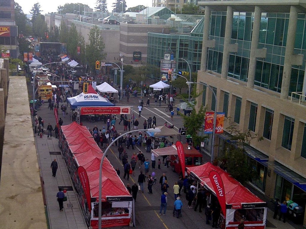
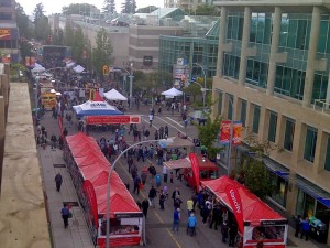 |
| The 2013 Uptown Live event- a great compliment to the Hyack Parade. |
And less like this:
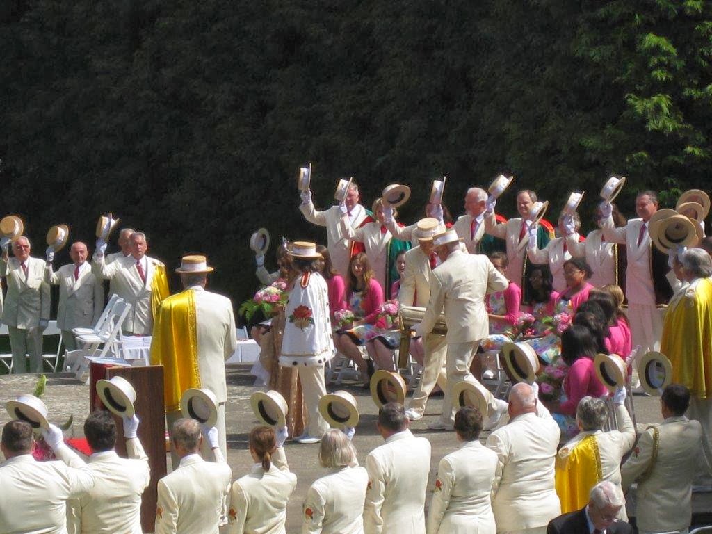
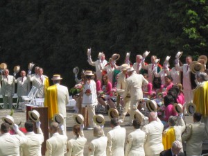 |
| The Royal Rosarians of Portland preparing to “knight” the president of Hyack |
Much like Douglas Smith stated in his report, I want a Hyack that represents New Westminster in a modern, meaningful way. Events like the Columbia StrEAT Foodtruck Festival, Uptown Live and the very successful rejuvenated Hyack Canada Day Fireworks are better examples of how our City can benefit from Festival funding and the hard work of volunteers. We drew the locals out onto the street to meet and mingle, and we drew people a SkyTrain-ride away into New Westminster to see our businesses, our downtown, our waterfront, and hopefully we put on a good enough face that they will return.
A little Pomp and Ceremony can also be good idea, if it serves to motivate volunteers, bring community together, and increase awareness of the organization and its benefits. Many would doubt, however, what exporting our pomp and ceremony to places like Ellensburg (where!?) Washington does to boost New Westminster’s profile, community spirit, or business connections. This is the case being made by some right now, but there is clearly a fundamental disconnect between the people who criticize these types of activities and those who partake in them. Honestly, I don’t know how this letter argues the case made in the first sentence – to many readers, it argues the exact opposite.
Perhaps the question I have not addressed is – Why do I care? Why should anyone care?
Those who regularly read this blog (Hi Mom!) know I am not the type to stand back and watch when a situation needs fixing, I would rather help, and encourage everyone else to help. That is the reason I had the conversations I did with the people I mentioned above. For the most part, I didn’t necessarily seek them out and corner them on the Hyack situation, but when I did run into them socially or on the street, the Hyack situation came up in conversation. Admitting I didn’t really understand the situation, I tried to get as much information as I could, mostly to separate the rumour and innuendo from the reality.
My first impression was, as I stated in August- this is an important organization in my community that I want to see operate successfully. When faced with the opinions of the “two camps” described above, I found myself agreeing with the later, more “changey” group. With reflection, it seemed obvious that this was my natural viewpoint, because I am not Member, and the traditions and “old way” of doing things were basically invisible to me. I had no frame of reference.
So I joined Hyack, and encouraged people I know to do the same. When there was talk of a September 10 special meeting of Hyack to determine the fate of Douglas Smith and/or the Executive that had him fired, I decided I wanted to join, attend that meeting, and hear the two sides argue their case. I also canvassed some of my social group to do the same, for the sake of everything that Hyack has done for the City, and the potential inherent in the organization. Some of my New West network reacted with surprising vitriol, told me the organization was not worth saving, or didn’t understand why I thought they might care. Others saw where I was coming from, got that the organization was a part of the community, and might be worth saving, if only because of the positive changes that have been seen in the last couple of years.
Then the September meeting was postponed, then cancelled, with no explanation to members or the public. I assumed the parties were working out the details of a settled conclusion and everyone was getting back to work. I could not have been more wrong.
I have not been contacted by Hyack since joining in the first week of September (although they wasted no time cashing my $55 cheque). Frankly, I have no idea when or how they meet, or even how I can get involved. The employee who received my membership forms is apparently no longer with the organization, leaving the same day that Douglas Smith decided to end his short return. Admittedly, the organization has bigger concerns than keeping lil’ ol’ me informed, and I haven’t gone out of my way to seek clarity from them, but as a new Member, I expected some kind of hello. Meanwhile, competing letters to the editor demonstrate very effectively who is in each of the two “camps”. What I do not hear is anyone looking for points of resolution. I also don’t hear anyone talking about a game plan or a way forward. Instead, one of the directors muses about splitting the organization up, while concurrent heart-felt, impassioned defenses of Hyack traditions fail to acknowledge that there may even be a problem.
Love it or hate it, Hyack is a vital part of our community – this is not just about the money taxpayers contribute to the organization (although that does matter), it is about representing the public face of the City. Hyack is quick to point out their efforts are all to promote New Westminster, so what impression of New Westminster are they currently showing? Every person who has staked their future on the success of this City should care about what Hyack represents in this town, and how they do that. For this reason alone, members, sponsors and the community need to know that Hyack is not just burying its head in the sand hoping this blows over, but is taking steps to address the criticisms, manage their structural and governance issues, and find a place in the New Westminster of the 21th Century.
I realize just by writing this blog post, I run the risk of making enemies. That is not my intention. Many will disagree with me about this topic, and some will take it personally. I hope those who do will reach out to me and set me straight, and I will be happy to print their reactions here, unedited. In an absence of certainty about motivations and reasoning, I always appeal to Hanlon’s Razor. I assume everyone involved here has the best interests of Hyack and the City in mind. However, no-one seems to agree on what those best interests are, never mind how to get there. The fact so many community members, even the normally “well informed” ones, are trying to figure out what is happening is not a condemnation of us, it is a condemnation of Hyack for not communicating effectively with its constituents. As a member of the community who wants to believe in Hyack, I am struggling to explain to others why.
Up to now, too much of the media conversation has been about entrenching positions, not about moving forward. Yes, the Hyack Festival Association has a proud 40 year history, but this City and many of its traditions have a history 3 times that long. The City will be able to exist and maintain important traditions without Hyack. There are other organizations, established and burgeoning, that would be happy to step in and take their share of that $140,000 in annual taxpayer support Hyack receives, and use it to promote the City, our business community, and our History. I’m not saying that is the best or most desirable result at this point, but those pulling the strings at Hyack have to keep that in mind.
Therefore, Hyack’s first priority right now needs to be convincing us – the City, the community, and their sponsors, and their members, that they are the best option the City has to promote the public face of New Westminster and bring community events to the Royal City.