Meeting with Coquitlam

Members of New Westminster and Coquitlam Councils, with staff support on both sides, had a great meeting yesterday to discuss the Brunette Interchange project.

The meeting included a tour of important locations on both sides of Highway 1. Both Councils took the opportunity to share ideas and issues, and have a better understanding of the many concerns with the current traffic through this corridor and with the potential solutions offered by the Ministry of Transportation.

I still have serious concerns with this project, but was really pleased with yesterday’s discussions between the two Councils. The meeting was positive, respectful, and informing, and I am looking forward to the discussions ahead.

Open letter on the OCP

I receive quite a bit of correspondence as a City Councillor, and I try to reply to as much of it as I can. Sometimes the time just isn’t available, and sometimes the writer doesn’t really leave a space for response (like the racist tirades I receive from “Immigration Watch” every week. Ugh, those guys are relentless).

I rarely make my responses public, as people writing may not like the idea of me writing in a public forum about their ideas, concerns, or opinions. However, recently a letter I received was also sent to and published by the local newspaper. In this case, I thought it appropriate to make my response public. There has already been a bit of social media push-back about this letter, some of it not very respectful to the writer, so I avoided responding via the Record for fear of “piling on” and making that conversation space less comfortable for anyone else interested in expressing an opinion.

We need an open discussion about things as important as the Official Community Plan. however, we also need to make sure the discussion is factual. So with that in mind, and with respect to the letter writer (whom I have met and is a very nice woman with honest and strongly felt convictions), here is my response as sent to her through e-mail a few days ago.

Mrs. Dextras.

Thank you for taking the time to write a letter to Mayor and Council regarding the OCP process. I know you are passionate about your neighbourhood, and am happy to see more voices from Glenbrook North take part on the public engagement.

However, I would like to correct a few misconceptions that I read in the letter as published in the Record, which were also manifest in your presentation to the GNRA when I was there.

The land use designations indicated in the draft land use map during the latest round of public consultation were not “arbitrarily” designated by planning staff. They were the product of more than two years of background data collection, public engagement, workshops, surveys, planning analysis, and conversation around the Council Table. Some earlier drafts presented at public meetings included more or less density in that area of Glenbrook North, and indeed in every neighbourhood in the City. The draft map you now see was developed through lengthy discussions of planning principles, and significant public feedback. There is nothing “arbitrary” about it.

Land Use Designation is not zoning. I know we have heard this more than once, and you have changed your language slightly to reflect this point, but it appears you are still conflating the two principles. The OCP is not a tool to change the zoning of your property, and there is nothing in the OCP that would force a person to sell or redevelop their home. There are currently no rezoning plans for your street, and your “property rights” are in no way reduced by the land use designation

The OCP update process was not initiated by this Mayor or Council, but began in early 2014 under the previous Mayor and before I or my colleague Councillor Trentadue were elected. The current OCP was developed in the 1990s, and though thoroughly amended over the years, was no longer reflective of the reality of New Westminster in 2016. As the Development Permit process to control development relies on an effective OCP, an update was necessary, and I vocally supported it while running for Council, however, I did not initiate it.

You also appear to have a mistaken understanding of the relationship between an OCP and the Regional Growth Strategy. The latter is required for regions experiencing growth (as we are) and s.850 of the Local Government Act (LGA) sets out its requirements. A Local Government OCP is required by law (LGA s.868) to include a Regional Context Statement that outlines how the OCP addresses the RGS, and how they will be made consistent. As such, local governments are required to follow the guidelines of the RGS, although they have considerable flexibility in how they meet those guidelines. In fact, the ruling you cite (Greater Vancouver Regional District v. Langley Township) found that the decision to add density to a protected area by Langley did not constitute a violation of the context statement, but was within that flexibility allowed to the City. Our Council is, indeed, legally bound to adopt an OCP that meets the RGS guidelines.

Your repeated assertion that 450 townhomes will be built on 5th Street in the next 20 years is difficult to reconcile with the draft OCP and guidelines. The west side of 5th street in Glenbrook North (outside of the part already converted to multi-family and commercial use near 6th Ave) is approximately 7 acres (not 15), perhaps 2300 linear feet of block face. With the guidelines proposed in the OCP, this would hardly accommodate a quarter of the townhouses you imagine. With a large number of residents (such as yourself) dedicated to stay in your homes, and not interested in exercising the expanded property rights an OCP amendment may afford, then it is safe to say many, many fewer than this will be built.

Where you are not incorrect (as it is an opinion) but where I strongly disagree with you, is in the assertion that young families like the one profiled in the Record should not be welcomed into our community, and we should not be developing housing policies to accommodate their needs. For a City, indeed for a neighbourhood, to be a livable and vibrant, it must remain accessible for people at different stages of life. I believe in the modern urban planning concepts that a community needs to include places where people can live, work, play and learn in close proximity, as the alternatives are ultimately unsustainable for the environment, for the economy, and for our social systems.

Nonetheless, I am disappointed to hear that your experience at one of the OCP Open Houses was not welcoming, or that you did not feel that your concerns were addressed. I attended several of these events, and never got the sense that staff were hostile to ideas that challenged the draft plans presented (although I occasionally heard participants passionately disagree on matters of principle or specific details). If you did not feel welcome to participate fully, that was indeed a lost opportunity, and I apologise. That said, the correspondence received from you and your neighbours has not been ignored, but has been read, included in the official record, and will be considered by Council as the final OCP is presented in the spring. I have listened to your concerns, have read your correspondence, and very much appreciated your hosting me for coffee in your home on Thanksgiving weekend to discuss your concerns with the process. I am, however, chagrinned that you continue to harbour false ideas about the meaning of the OCP update, and make oft-rebuked assumptions about the impact on your neighbourhood. Perhaps a more fulsome discussion may have provided some clarity to the points above (for example, I cannot stop emphasizing this is not about rezoning).

You are (of course) welcome to continue that correspondence, and to take an active role in the Public Hearing that will be required prior to Council adopting a new OCP.

Thank you again for taking the time to get involved in your community!

Patrick Johnstone

Plans and Promises

I have had interesting interactions on social and traditional media this week, and it got me thinking about plans the City makes, and where those interact with promises made by politicians. I am new to making the latter, have made the former for a long time, but haven’t really thought about the differences. let me see if I can tie this together into a cogent discussion.

It started with this Facebook post:

Hey Patrick, Earlier this year you spoke of the pedestrian and cycle improvements that were soon to be built along Braid. What does soon mean? You spoke of right away, seems you’ve become just another politician, promises promises…….

I have a slightly vague memory of having this conversation, as it was around the time some public consultation was being planned around this project. I knew the project was coming along because we talked about it at ACTBiPed, and because I attended an event as Acting Mayor just before the last Federal election where an MP from and adjacent riding announced some federal funding to help fund the project.

So I replied to the Facebook post with a link to the project page (above), and slightly cheekily followed with “no promises, though”, because it seemed to me the poke about “promises” by my inquisitor was slightly tongue-in-cheek. Or maybe not, as another person took slight offence to my flippant attitude, requiring yet another response by me that provided more detail, proving once again that Social Media is a terrible place to infer nuance.

The longer version of my response is that the project is coming along, but this isn’t really something I would think of as a “political promise”. I don’t think anyone ran for Council supporting or opposing a plan to put green separated lanes on the north side of Braid Street to connect to the United Boulevard bikeway. However, some of us were more supportive than others of the Master Transportation Plan for the City adopted just before the election (I don’t think anyone NOT supportive of it was elected). I am not only still supportive of it, but am supportive of rapidly implementing the active transportation measures included in that plan, including filling some of the important gaps in our bicycling network.

When it comes to building certain connections, though, that is really a complicated discussion between Council, staff, our Advisory Committees and other stakeholders, and is influenced by the capital budget and various priorities. This particular project was seen as a good chance for some senior government grants (applied for and won), represented an important gap, and was generally seen as ready to go. Drawings were created, some cost estimates done along with some public and stakeholder consultation. Capital budget was set aside in the 2017 year to do the works. My “supporting” this plan was a very minor part of the plan coming together for 2017, even as one of the members of a seven person Council.

That said, I can see a couple of potential issues that may prevent this from happening on the existing timeline. If you look at the poster boards from the Public Consultation, you will note that the map has red lines on it. Those are property lines, and a large part of the project is within rail property. I understand that we have agreements for these properties, but as we are learning with whistle cessation measures elsewhere in the City, the way rules and agreements work on rail lines is not always straight-forward, and it is best not to be too hasty predicting how those agreements will work out when it comes time to roll out the excavator. The second issue is, of course, the upcoming Brunette Interchange project by the Ministry of Transportation. I can’t tell you too much about it because MoT has not yet released their project drawings, but if there are changes in how Braid Street works through this area, we may need to go back to the drawing board. I don’t know the answers to the questions, nor are they completely in Council’s control.

I have every reason to expect this project will proceed in 2017 as planned, but all plans are subject to change, based on the rule of best laid plans. This doesn’t mean we won’t build a safe cycling and pedestrian route between Braid and the Bailey Bridge, it just means that the connection may not arrive exactly as we envision it today, or on that timeline. We’ll stick to the goals, we may need to change the plan. Stay tuned.

As for “promises”, I remember promising to support the Master Transportation Plan, to support and work towards implementation of the transit, pedestrian, and bike infrastructure improvements in that plan, I promised that stakeholders like HUB and the members of ACTBiPed would be involved more in planning these types of projects. I also promised I would do everything I can to be the most open Councillor about talking about how decisions around the Council table are made – mostly through this blog and other Social Media, hoping that openness would build more trust in the work City Hall is doing. If we make a decision you don’t agree with, I hope you will at least understand my motivation for making that decision, and hopefully you will be angry at me for the right reasons.

Which brings us to this week’s editorial in the Record, where they are critical of Council’s approach to the Q2Q bridge. They are right that the current situation is a let-down, and that, ultimately, Council has to own that disappointment. I may (cheekily) offer surprise that they claim to have known all along it was impossible to build the bridge, and didn’t bother to point that out to anyone, even when previous engineering reports suggested it was well within scale of our budget, but that is not the part of the editorial that made me retort. Instead, I was pretty much with their argument until this:

It doesn’t take a political scientist to figure out that Queensborough’s project would be low on the priority list. In fact, you just have to drive down Ewen Avenue to know that Queensborough often gets the short end of the stick.

I have to respectfully disagree with the suggestion that this Council ignores Queensborough as some sort of political calculation. That the Editor used Ewen Avenue as an example suggests to me they have not been to Queensborough in some time. Ewen Avenue is undergoing the single largest road improvement project in New Westminster in the last decade. Two years into a three-year $29 Million upgrade, the entire length of Ewen Avenue is going to be a brand new transportation spine for all modes. It has been a big, disruptive construction project, but the end result is becoming visible now, and will change how Ewen Avenue connects the community in a pretty great way.

If the issue is priorities, the Editor may be reminded that the Q2Q plan was part of a series of DAC-funded projects that started with $6.2 Million towards the $7.7 Million renovation of the Queensborough Community Centre, including the opening of the City’s first remote library. It included another $5 Million in Park and greenway improvements for Queensborough (including the South Dyke Road Walkway, Boundary Road Greenway, Sukh Sagar and Queensborough Neighbourhood Parks, and a pretty kick-ass all-wheel park). These were the first thing done with DAC funds, not a low priority.

Just two weeks ago at Council, we turned down capital funding support for a Child Care facility in Uptown because we placed the need in Queensborough as higher priority, and dedicated our limited child care funds toward filling that need. That isn’t “the short end of the stick”, that is including Queensborough’s needs along with the other neighbourhoods of the City when directing limited resources towards where the need is greatest. This council has a record of fighting (and winning!) to keep Queensborough in the same federal riding as the mainland, and a record of fighting (and losing) to keep it in the same provincial riding. Queensborough has never been an afterthought at the Council table during my time there, but a neighbourhood we continue to invest in and be proud of.

The situation for Q2Q sucks, there is no way to dress that up or say it more elegantly. A set of projects was conceived a decade ago, and of them, this project does not appear workable in the current form. The work is ongoing right now to determine how the remaining DAC funds can best be used connecting Queensborough to the mainland, and I am hoping a new and viable plan will come along soon. Call the current set-back a broken promise if you must, but the decision to not move ahead with a $40 Million option right now is not proof of a City disregarding one neighbourhood, it is a matter of understanding our fiscal limits as a City of 70,000 people with dreams perhaps bigger than our reality.

The Q2Q quandary

No doubt the biggest let-down last Council meeting, indeed the biggest disappointment of my time on Council, was the releasing of the updated projected cost numbers for the Q2Q bridge preferred concept.

A short version of this project is that the City will receive “DAC” funding from casino revenues to spend on a fixed pedestrian link between the Quayside and Queensborough, based on a 2007 agreement between the City and the Province. Based on some very preliminary cost estimating, the project was put in the $10 Million range, so Council placed that amount in the budget to support the project. The idea has seen several rounds of public consultation, with several design concepts sketched out and debated. Ultimately, a design that would be acceptable to the regulatory authority that controls river crossings (i.e. a design that allows safe and unfettered barge traffic) and still allows reliable pedestrian use was developed to the point of doing detailed cost estimating. That cost came back at a little over $39 Million. The City doesn’t have $39 Million, and it is hard, with so many competing capital priorities, to see how we can get $39 Million to make this project work. I’m frustrated and disappointed.

However, regular readers (Hi Mom!) know I rarely stick with the short version, so I thought I would go into a bit more detail about how we got here, and where we may go from here, because I want to slay some of the social-media-derived myths about the project.

This project was not killed by NIMBYs. Over the last 10 years or so, the Q2Q project has gone through several iterations. The DAC agreement was in 2007, but it was always anticipated that the Queensborough Community Centre update, other park improvements in Q’Boro, and the MUCF (now called Anvil Centre) would be the completed before the Q2Q project began. The DAC funding did not arrive as one big cheque in 2007, but is allocated as projects come along, and as casino revenues come in. Q2Q was a little further down the timeline.

During those 10 years, preliminary planning work was done on a few concepts for a “fixed link”. At several times, early concepts with very preliminary sketches were bounced off of Quayside and Queensborough residents. For lack of a better term, these concepts were “focus grouped” to test public reaction and determine what potential concerns residents on either side and other important stakeholders may have. They were also run past pedestrians and cycling advocates (like me) to see if their needs were being met.

Three different “high level” crossings were evaluated about 8 years ago. These would completely span the navigable channel at a height that met regulatory requirements (and therefore be about the same height as the Queensborough Bridge). There were some concerned neighbours about the mass of the structure, and some were concerned about the fate of the “Submarine Park”, but there were also some functional and cost concerns with this early concept.

Cable stayed bridge Option 1, estimated cost $19 million.

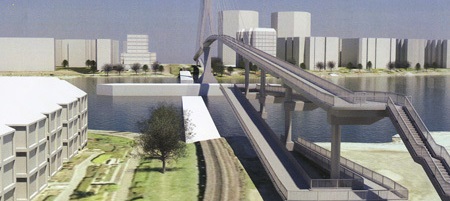
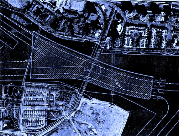
At the advice of the Council of the time, staff stepped back a bit to take a look at options that didn’t go so high as to span the navigation channel, and would require a lift, swing, or bascule section to open and allow boat passage. This opened up a large number of potential options, including new alignments. For a variety of technical reasons, a bascule was determined to be the best option for a lightweight span with a limited footprint. This evolved, through a type of value engineering, into a couple of models of twin bascules – one at a moderate height (but requiring elevators to be accessible) and one at a low enough height that grades were accessible (but requiring more opening/closing cycles, due to reduced boat clearance).

These also saw some limited public consultation, and some neighbours expressed some concerns about the location of one of the “elevator” options. However, Council felt we had enough information to do a more detailed cost analysis of the most practical alternative. That alternative is the one that came back to Council with the $39 Million price tag. The concerns of neighbours were part of the considerations, but the $39 Million was the deciding factor.

Cost estimates are necessarily iterative.
Someone asked me how this project ballooned from $6 million to $39 Million? The simple answer is it didn’t.

The original DAC funding formula envisioned a ~$10.5 Million crossing. I can’t speak to how that number was arrived at (I wasn’t even a local blogger in 2007!) but I can guess it was a simple bit of math: pedestrian bridge, 200m span, look at a couple of recent examples around the country, don’t worry too much about details (the City can always make up a shortfall if needed from their capital budget), and since we aren’t building it for another decade, any estimate we make now is likely to be off anyway. The point wasn’t to plan a bridge at that time, but to earmark parts of this one-time funding source towards worthy projects.

The City then went to work on some of the other DAC projects: the Anvil Centre, the Queensborough Community Centre, and other waterfront improvements in Queensborough. To better make the financing work without having to enter too much long-term debt, they re-allocated some funding between DAC project areas. Consequently, the DAC funds for the Q2Q are now only a little over $6 Million, but another $5 Million in capital reserve funds was earmarked to cover the difference, meaning we still have the ~$11 Million originally earmarked.

As far back as 2009, order-of-magnitude cost estimates for the high-level crossing were in the $15 – $22 Million range. This is when the City went back to the drawing board to see if there were more affordable options, and also started to look around for sponsorship and senior government grant opportunities to see how much of a funding gap could be filled. By 2013, preliminary estimates for the first bascule concept were given as cost of $10.4 Million.

Fast forward to 2016, after Council asked staff to spend a little money on getting some detailed cost estimates on the more refined design, where $11 to $15 Million was still the general thinking, as we became aware of some of the significant engineering challenges. These included the need to install pillars in the river (not just on shore), the barge collision at Queensborough back in 2011 which definitely triggered a closer look at the safety factor for large vessels through the north arm, and the mechanical and operator costs for a bascule bridge. It seemed likely these would offset cost savings that might be realized by not going 22m high and building 1km of ramps. Add a few shifting project priorities as the public consultation and interest in the project increase (Strong enough to carry an ambulance? Wider than 2m for greater pedestrian comfort? Offset to reduce impact on vulnerable riparian habitat on the Q’Boro side?) and things start to add up.

That said, cost estimating for engineering projects is a complicated business, and like most engineering, you get what you pay for. Early estimates were preliminary, in that a lot of the project definition we not yet completed. After working to refine a project enough that we could confidently define important parts of it, Council recently directed staff to get a Class ‘C’ cost estimate, which is considered to be accurate to about 30% variance (i.e., costs are unlikely to be 30% higher or lower than the estimate). We could spend a lot more money to get that estimate down to Class A level, but when the estimate we have is well outside of our affordability range, we need to decide whether the extra design work required would represent money well spent.

I can’t speak too much about the decisions and work done before I was elected, but this webpage has links  to the reports that have come to Council since 2013, where you can (if you care) walk through the public process planning for the Q2Q has been.

q2q5

This project only appears simple
I wrote a blog post a little while ago that talked about some of the complications and compromises required to make this project work, then followed up to answer a few questions, so I don’t want to go through all of that again. This is not a simple project to build, for a variety of reasons, and it is very different than a simple pedestrian overpass. Strapping a sidewalk onto the side of the existing train bridge raised other issues that seemed insurmountable. Many other proposals I have heard (a bridge to Poplar Island then a second to Queensborough, for example – why build one expensive bridge when you can build two at twice the cost?) have also been similarly evaluated, and either didn’t make sense at the time, or had significant issues that seemed to prevent it happening. If it was easy, we would have done it already.

Q2Q is still a good idea!
This is a serious setback, but I want to make it clear that I am still a big supporter of this project concept. A fixed pedestrian link between Quayside and Queensborough makes so much sense at so many levels. It has a certain tourist appeal (especially if you can build something aesthetically pleasing), but it isn’t for tourists. It is to connect people and businesses on both sides of the North Arm better, it is to connect the great pedestrian and bike routes on both sides of the North Arm, it is a vital piece of transportation infrastructure for the people of New Westminster, and for the region.

Is a passenger ferry a good substitute?
No. I do not think a passenger ferry service is a substitute for a fixed link. As a vital piece of transportation infrastructure, a fixed link provides certainty and reliability that a ferry service can’t. I think of it like a bus route (which can always be cut at the whim of a government) compared to a light rail line (which is a fixed asset difficult to remove). There is reason the bus lines running down Hastings have not resulted in the kind of development that the Skytrain running down Lougheed has – the latter is something people can count on still being there and reliable 20 or 30 years down the road – certainty is an incentive to investment. There is also the strange psychology of having to schedule/wait for a ride, vs. just being able to hop on a bike and spin across at the drop of a hat. The former “feels” like a tourist attraction, the latter more like a transportation link.

However, in the meantime, I think it is worth trialing a ferry service to determine the interest, and perhaps to argue the need for a more permanent link. Or maybe (I sincerely hope) the trial will prove my skepticism wrong. These cannot be the little aquabuses that run to Granville Island – currents and logs and heavy industrial traffic mean the Fraser needs a somewhat more robust design. We will need to invest in some dock upgrades and look for a partner to run the show. It is highly unlikely that a ferry can be made accessible for people with mobility issues. However, with luck we can have something running in the late spring.

What now?
To me, the fixed link dream is not dead, but it is definitely suffering a bit. I am hoping for a miracle some really creative thinking to come along that makes the transportation link more accessible and permanent. I am interested in looking at a more stable and reliable ferry option (like a fixed cable ferry), and wouldn’t turn my nose up at urban tramway ideas (could we connect to New West station?), or a pedestrian tunnel as is common in England, and would get us out of our 22m clearance issue. There may even be more efficient and elegant bridge designs that haven’t seen complete costing analysis but may thread the needle between what is acceptable to the river users and what works as urban transportation infrastructure.

It breaks my heart that we don’t have an immediate path forward on a bridge. I think it is a really important idea for the City, I just wish I could responsibly say the cost as presented made sense for the City.

Ask Pat: Whither bike lanes?

It’s been a while since I answered an Ask Pat question, and there are a bunch of them in the queue, so I’m sorry if I haven’t gotten to yours! I’m a little over programmed right now. All good stuff, just too much! So here we go with an Ask Pat from a guy with a suspicious name:

Patrick P. asks—

Hi Pat. I find it totally bizarre that while we allow new apartment towers to be built with hundreds of new parking spots for cars, it seems no thought has been given to mitigating all the extra traffic on the road, or to giving people a cycling alternative — or to the impact on our environment. We have no dedicated (separated) bike lanes, and my bicycle commute to central Burnaby has been a challenge as there are no signs indicating a safe route. Moreover I am very worried for the safety of children like mine who want to get around town by bicycle.
Are there any plans to make our city more cycling friendly, particularly around shopping areas? What can I do to help?

I hear you. As a person who rides a bike for recreation and for daily chores, and tries to commute by bike as much as I can, with a partner who commutes to Burnaby every day on a bike, I know we aren’t yet where we should be as far as cycling infrastructure. Short answer to Question 1 is yes, answer to Question 2 is way down below at the bottom of this post, so fix a cup of tea, sit back and enjoy (or just scroll past all the fluff to the bottom couple of paragraphs)

There is a strange thing about traffic in New West: it mostly isn’t us. Two great statistics that tell you about our traffic problem is that the City has the highest percentage of its land dedicated to roads of any municipality in BC, and that New Westies drive less and own fewer cars per capita than the residents of any municipality in BC (with the exception of the City of Vancouver). Yet traffic is our #1 problem, because people like driving through New West. Presumably, they like it because they don’t have better options, not because of the nice views or the friendly demeanor of our residents.

So in that sense, if we have a car traffic problem, it isn’t the people living in towers on top of SkyTrain nodes. The extra 300 residents with (following our demographic trends) 200 more cars, used only 50% of the time, are a drop in the bucket of the 400,000 cars a day (a number I do NOT have a source for, but a number used anecdotally to describe our through-traffic for rhetorical purposes by virtually everyone) that ply our streets. There is an entire political conversation about whether parking minimums for new developments are good public policy, but I don’t think that is where you are going with your question.

Arguably, providing more housing alternatives in New Westminster (including those towers on SkyTrain nodes, and “missing middle” family-friendly housing forms) will act as a disincentive to people commuting through our City, by providing people better options that living to the east of us when they work to the west of us (you can change either of those directions to point to the same problem). The entire model for the Regional Growth Strategy and Regional Transportation Plan is based on that idea – compact, transit-friendly, mixed-use development as opposed to car-centric sprawled single-use development. New Westminster is (IMHO) leading the way for this development model regionally, and is, unfortunately, still straddled with the traffic impacts of neighbouring communities not talking as active a role in changing how they develop to suit the regional vision.

But you live in New West, work in nearby Burnaby, and want to be more comfortable riding your bike to work and to shop. Even better you want to feel safe sending your kids off to school riding their bikes. You (and I’m not just saying this because of your great given name) are part of the solution, and are fortunate to have the opportunities in your work/life/health/etc. to make that choice. The City should be making it easier for you.

I think we are, but perhaps not as quickly as either of us would like, through implementation of our new Master Transportation Plan. Passed before I was elected (although I served on the advisory committee), this plan represents a monumental shift in how we, as a City, are going to look at investing in our transportation system.

First off, it places active modes at the top of the priority list:

heirarchy

To me, that means we are going to spend less on making the asphalt smooth, and more on making the sidewalks, bike routes, and transit system operate better for all users. To you and me, that may seem obvious; to enshrine it in a master planning document means we are charged (us elected types and staff of the City) to do it, and put our budget where out mouth is.

What does this look like on the ground? For the first time, New Westminster is investing in green paint. It has taken a bit of time, and in the first year of MTP implementation we really invested more in primary pedestrian and transit accessibility (we are aiming for 100% accessible sidewalk curb cuts by 2018, and 96% accessible bus stops, which leads the region on both counts). We have also staffed up a bit in our transportation department to expand our ability to plan and deliver these projects. This next phase does include some significant cycling improvements.

We have already identified some “quick wins” for cyclists, where a bit of engineering can make a few key links on our established greenways work better. You will see things at 20th and London Street, 7th Ave between Moody Park and 5th Street, under the Queensborough Bridge in Queensborough, and between Braid Station and United Boulevard (for a few examples) right away. A few other slightly more challenging issues (a hill-friendly bike route connecting Downtown to Uptown) are being worked on, as are designs for the Agnes Greenway, and an extended greenway from Braid Station to Sapperton Landing Park. Safe Routes to School and Safe cycling to school are also high on the priority list.

As an aside, you probably have no idea how much that green paint costs. On a square-foot basis, it would be cheaper to do engineered hardwood. But we will probably save long-term on maintenance.

The best I can offer you is small relief in the immediate future, with a long-term vision towards a properly developed integrated and complete bike network. It is going to take a few years, but the MTP gives us the vision, and I think Council has the political drive to make it happen. When compared to Vancouver, we are a small municipality with a limited budget, so multiple separated bike lanes and the assorted infrastructure (lights, signs, paint, paving) to make them really work ideally, are an expensive prospect. I can’t guarantee they will arrive tomorrow, only that this is the direction we are headed, and I’ll be advocating for our budget allocations to suit the priorities we have set through our MTP.

If you think you have good ideas about cycling infrastructure needs in New West, there are two ways you can help.

You can apply to join the advisory committee in the City that works to make New West a better place for cyclists, pedestrians and transit users: ACTBiPed. I happen to chair that committee, and served on it for a couple of years before I was elected. I think we have managed to make it an effective group where staff and community members work together on “big picture” strategies, and also take time to dig into the detailed design elements of new infrastructure to assure they work for active transportation users. The City is receiving applications right now for 2017 Committee appointments, and you can get all the info you need to apply right here.

If working within the system doesn’t satisfy your needs, you can also get involved with the local HUB Chapter, who advocate for better cycling infrastructure and funding, locally and at the regional level. New West hosted their AGM a couple of weeks ago, and it was great to hear about the work being done in the local chapters across the region. The local group is also instrumental in getting elementary school kids trained to ride their bikes safely, running cycling safety and skills courses with the School District. They are also a very helpful voice at the table when we are making decisions about cycling infrastructure in the City. You should become a member, and then decide if you can give them your time, donate them some money, or whatever combination of the two fits your lifestyle the best!

Finally, you can ride your bike, and use SeeClickFix when you run into problems, to let City staff know that good cycling infrastructure is wanted, and bad cycling infrastructure is noticed, by residents of the City.

We are working on the MTP, on making this a better place to ride a bike, but we could always use more motivation from our residents!

Tree loss & protection

A few years back when I was still complaining about the City’s lack of action on a Tree Bylaw, I pointed out the presence of a great beech trees on my street. This was one of three, gigantic, more than 100 years old, trunks more than a metre across. They provide so many benefits to the neighbourhood and the community: shade, noise abatement, wildlife habitat, storm water detention, cooling the air.

These three had “heritage” protection, so they were unlikely to be capriciously removed, but that limited protection was not afforded to most trees in the City. The vast majority were afforded almost no protection – if the landowner chose to remove them, she was good to go. A Bylaw was needed, and through the lengthy development of an Urban Forest Management Strategy, these newly-monikered “specimen trees” are protected from removal by short-term thinking.

I was shocked last week when a neighbour came over to complain to me that the City had allowed one of the three grand beech trees to be removed. “I thought there was a Bylaw!”

Alas, I wandered over to the property in question, and indeed one of the three is no more. No more than pile of alarmingly large slices of wood, as the arbourists were working on site clean-up. I noticed a Tree Removal Permit attached to the house, so clearly they got permission, but I felt the loss as much as my concerned neighbour. So I called up staff and we have had some discussions about this tree.

*I am trying to be careful here, because the homeowner who owned the tree did not do anything wrong, and I don’t want to cause them embarrassment or any kind of trouble, but a few people have asked me about the loss of this tree, and now there is a story in the Paper, so I felt like I needed to comment about it here. It will be difficult to tell the story without providing clues about the location, and I think people need to know the story of the loss of a community asset like this. So please, be respectful of the homeowner who – I’ll say it again – did nothing wrong here. If you feel the need to act out or speak up or react negatively, do it to me and Council, not them. Thanks.*

The story of this tree is that it was suffering from senescence, which is the technical way of saying it was dying of old age. I don’t want to get into the detailed description given by the arbourist, partly because I’m not an arbourist and may not clearly translate their terminology, and partly because there are probably FOIPPA issues in releasing a report provided to the City without passing it through the privacy protection filter.

The now-gone tree in 2011, looking pretty happy. (ripped from Google Street View, no permission requested)

Our efforts to look back are, fortunately, assisted by technology. Google Street View has photos both from 2011 and from 2016 on adjacent streets. The visible decline of the tree is obvious. It looked (again, to my untrained eye) healthy in 2011, but by 2016, the leaves are sparse and diminutive, many branches looking bare. There was quite a bit more evidence of decline in the arborist report, but there is no doubt this tree was not very happy.

The same tree in June, 2016, looking sparse and lob-sided at a time of year when it should be in fill bloom. (also ripped from Google Street View)

The contributing factors to a tree like this entering full-plant senescence are usually multiple. Sometimes there is an attack by a pest, and the drought-like conditions we have experienced for a couple of summers probably hurt the resiliency of the tree. It is possible (I’m just speculating here) that poor pruning practice or damage to the roots for home improvements may have also been a factor, further reducing the ability of the tree to cope with declining productivity.

In the end, the things that made the tree so majestic – its great size and hulking branches – are the things that made it a “hazardous tree” once that decline began. The arbourist did not think this was a temporary setback, and that recovery was unlikely. what was more likely was continued decline until the branches started to collapse, potentially onto a building or person. The homeowner got a permit, had a tree health assessment done, and received permission to cut the tree down.

As this is a “specimen” size tree, and a hazardous one, Schedule A of the Bylaw indicates that the homeowner is required to replace the tree, and the City collects security to assure that replacement takes place. Of course, putting a new dogwood or birch sapling in the place does not really “replace” a 100+ year old giant like what was lost. It will be decades until the replacement starts to provide the mass of benefits that the old tree did. But even this replacement policy did not exist before the Bylaw.

Which bring me to the point – the Tree Protection Bylaw does not mean no trees will ever be removed again. What it means is that the City has applied measures (call it Red Tape if you are so inclined) to act as disincentives to the removal of trees, and to provide compensation to the community for trees lost. When it comes to private property, that is about as far as we can go as a City. It has proven to work in other jurisdictions, though.

The Bylaw is only one part of our Urban Forest Management Strategy, but it is an important part, and this fall Council will be taking a closer look at the Bylaw application to see where it can be strengthened, and where it needs to be relaxed to make it more functional for residents. If you have opinions one way or another, please send Mayor and Council an e-mail or letter.

BridgeNet

I haven’t talked too much about BridgeNet here, the City of New Westminster’s fibre optic utility initiative. It is one of those things in the City that I am less involved in, as I am not on the Economic Development or Intelligent City committees, though it is an idea of which I am supportive.

There was a recent discussion in a community Facebook thread that breezed past traffic, talked about the current long-term lending plan, and various taxes and spending issues, but some good questions were raised about why and how the City is investing in fiber optic infrastructure. So instead of lengthening that already lengthy thread, I thought I would answer the questions here (and link back, of course). The questions are thus:

I am curious however why NW has ‘invested’ $9M of taxpayers money in a fibre optic network to compete with Canada’s four private sector service providers Bell, Telus, Rogers and Shaw?

The simple answer is that access to higher speed internet connections is something residents and businesses want, and is part of both the City’s Intelligent City initiative, and a part of our Economic Development Plan. There is a new generation of business, a new type of worker, where an internet connection is as important to their success as access to truck routes are to some more traditional industries. These types of value-added high-paying jobs are an important part of developing a City where people can work, live, shop and play in the same community. And the Big 4 Telcos are not bringing 1Gb service to New West any time soon.

Some are under the mistaken impression that the City is starting a Telecommunications company (“Telco”) to compete with the Big 4, but that isn’t the plan. If I can stretch the analogy of this being the trucking industry of the next century, it might cast a little light on what we are actually doing.

In most of Canada, consumers hoping to connect to the internet have to choose from one of the Big 4 Telcos. This is because those companies have had the financial wherewithal to build a full network, mostly off the infrastructure backbone of the telephone companies that spanned the country in the first half of the last century. In the data-as-cargo analogy, these companies are like the large railways. There are few of them, because they had to pay to install the infrastructure that they use (with significant legislative and material support from supportive governments, interested in “opening up the markets”) and as a result, they have a pretty solid grip on the competition within the market. They are, effectively, an oligopoly.

This doesn’t mean they completely lack competition. Trucking companies also move goods, and what they lack in might and capacity, they make up for in a built-in efficiency: they don’t need to build the roads or bridges they operate on. That infrastructure is built as a commons, and everyone can use them. Local, regional, and provincial governments build roads using your taxes, but they don’t run trucking companies. They can, however, choose where they build roads, and how they provide access – something they really can’t do with railways.

So it is with a dark fibre utility. The City is, essentially, building the roads (“fibre”) so that any trucking company (“ISP”) can come in and compete with the railways (“Big 4 Telcos”). There are many small ISPs who can and are willing to offer boutique and discount services in New West, but cannot build the trunk infrastructure needed to get into the business. Meanwhile, the Big 4 are concentrating their infrastructure upgrades in the biggest markets like downtown Vancouver and working to outcompete each other where the money is easy.

Far from competing with the Big 4, the City is building a fibre network that will open up competition, such that more companies can challenge the limited offerings provided by the Oligopoly, promising businesses and residents along the network much faster internet service, and more affordable and flexible service plans. We are not offering those services, but we are charging tolls to the companies that will offer them through the fibres we install. Those tolls will (for the first decade or so) pay for the cost of the infrastructure, and after that it will provide a revenue source that a future Council can use to offset taxes, much as the Electrical Utility currently does.

I guess New West has decided that running it’s own Crown Corps is a great way to ‘increase revenue’, a phrase I’ve heard repeated on several occasions at City Hall.

Yes, providing services that people want is a good way to increase revenue in the City, and it provides an opportunity to offset your taxes. Especially when a City leverages opportunities that come with operating roads and utilities, and can use its solid financial position and favorable Municipal Finance Authority rates, the City can provide things that people want for less money. Sort of the thing people who ask Cities to “operate more like a business” would suggest we do.

Governments are not for-profit businesses. I can write an entire blog post about how Governments and businesses are fundamentally different, but that would be a long digression at this point. Suffice to say, providing a utility service that improves the competitiveness of our business community, is attractive to residents and people who work at home, and doing it in a way that will first pay for its own infrastructure, then return value to future taxpayers, seems like a pretty good governance decision.

This $9M in this optional financing program also intrigues me seeing as, based on walking around town, this network at least appears to be mostly installed. How did we pay for it in the first place?

The network is not mostly installed. A couple of trunk lines are in the ground to allow communication between City facilities so our internal corporate network can run better. Those were paid for by taxpayers, like the rest of the City’s computer network system.

Perhaps what you are looking at (?) is the conduit we have installed – the plastic tubes that fibre can be fed through. The City was forward-thinking enough to install conduit while road and utility works have happened over recent years. Conduit is cheap, and it is easy to drop it in the trench while you are doing other works before the asphalt goes down. The Ministry of Transportation does similar things when they build major road projects, like the SFPR. Stick the conduit in, because you never know how you are going to use it in the future. in fact, BridgeNet will use MoT conduit for part of it’s system, a service BridgeNet will pay MoT for.

What we have not yet done (but are working on right now) is put fibre into those conduits, nor have we built the infrastructure at the junctions and end of the lines that would allow that fibre to light up. That stuff costs money, and we are investing in it now. We will also be investing in last-metre connections as customers sign up to access the services that the Internet Service Providers (ISPs) will be providing. That stuff costs money, and rather that use property tax money or dipping into reserves, it makes sense to borrow the money at the low rates the Municipal Finance Authority makes available to us, and to pay back those loans with the income earned from the operation of the Fibre Utility. Utility customers – the users of the infrastructure – will be paying this infrastructure loan back, not taxpayers.

BridgeNet is a pretty exciting initiative, and one that is about the future of the City. There was a great open house last month where industry leaders came to the Anvil Centre to talk about the potential that high-speed internet provides to Cities, to businesses, to institutions like Douglas College and our Schools, and to residents. We had four ISPs there, demonstrating the types of services they want to deliver, be it discount home 1Gb service or specific boutique offerings for office centres. There were hundreds of residents and businesses there, excited to look at the map, and all asking the same question: When will this service be coming to my street? The answer can be found at the BridgeNet Website, and the map you can find here.

Vacancy Tax

Homes in the lower mainland are getting to be too expensive for people working in the lower mainland to afford. There are few who would argue this point. It was all fun when we watched the $1Million line march eastward across the City of Vancouver, then the $2Million line, but now single family homes in New Westminster are regularly selling over $1Million, we cannot bring on alternate housing types (townhouses, row homes, cluster homes) fast enough, and high-rise condos are selling out before the ground is broken.

It is a classic market run, and people are both afraid to get in and afraid to miss the boat. This is a situation ripe for unscrupulous profiteers inside and outside of the semi-regulated Real Estate industry to start the raking in cash. However, those skimming value from an opportunity cannot be blamed for the problems that created that opportunity. Free enterprise, folks.

As with any long-emerging crisis, there is rampant speculation by people ready to pin the problem on their pet bugaboo, though few deny the complexity. I get weekly e-mails from racists telling me it is an immigration failure. People speculate (on thin data) about the number of vacant homes being held for investment. Efforts to bring more stock on line run up against “character of the neighborhood” arguments in Kerrisdale, on Commerical Drive, in Queens Park. Following on 20 years of dropping rates following the peak of the 70’s recessions, we have now had more than a decade of bargain-basement mortgages, making the borrowing of money to buy a house (or houses) the only sure investment for a generation. We have in-migration (foreign and domestic) pushing for more supply, limited physical area for growth, and a complete failure to fund regional transportation infrastructure that would improve the accessibility of regional housing options. Disruptive technologies and economic drivers (AirBnB, remote work, etc.) are pushing against zoning, taxation, regulation, and any attempt to manage a shrinking supply. Equally disruptive is the generational change caused by baby boomers cashing out “wealth” accumulated during an unprecedented post-war economic growth cycle while voting to strip apart the social contract that made it possible before it can be passed forward to the next generation. At the same time, real wages have been stagnant, failing to even keep up with a decade of record-low CPI increases (“it’s not a depression, and it’s not a recession. It’s an unprecedented kind of breakdown: a divergence, regression, implosion”). On top of this, the federal government, then the provincial government, got completely out of the affordable housing business, leaving local governments and a patchwork of social service agencies attempting to fill the gap with none of the resources to do the job.

It’s a mess (as was that last paragraph!) and it would be ridiculous to claim that any one of those alleged causes is the only cause. But a ridiculous reactions to unsupported claims is the current BC governance style, so here we go.

The BC Government has managed, for years now, to avoid addressing the root causes above in any meaningful way. To be fair, not all of the issues leading us to this place are provincial jurisdiction, but developing strategies to keep housing in our communities available and affordable is 100% provincial responsibility, thanks to the Constitution Act of 1980. However, the story has now become enough of a front-page annoyance that the Premier has decided it necessary to be seen to be doing something.

In the most knee-jerk reaction possible, they have called an emergency session of the Legislature to change the Vancouver Charter to allow the City of Vancouver to charge a tax on vacant homes. This is, in their defense, one of the short-term measures speculated upon by the Mayor of Vancouver, but no-one can seriously believe this is a going to solve the housing problem, nor is it clear how this spit into the ocean warrants an emergency summer sitting.

Not surprisingly, Mayors from across the region are perplexed about how this approach (which will only impact the City of Vancouver proper, as they exist under separate legislation than every other City in the province) will help or harm the situation in their housing markets, and the pressures they are feeling now that the problem has clearly become a regional one. But that is not the only problem they (correctly) point out.

The venn diagram that connects “vacant properties” with “non-resident” owners, “investment” owners and “foreign” owners is a muddy one – which makes applying a punitive tax to any one group a complex problem for the province or a City. Of course, we have no idea if the proposed approach will actually have any effect on the real issue at the core of this, which is (do I have to remind you?): homes are becoming uncomfortably expensive relative to wages. Realistically, we can be pretty confident it will not be a solution, but will cause repercussions across the region we cannot predict.

We don’t know what legislation will be introduced next week, but we know there is little chance that emergency legislation passed in a brief summer session will provide the complex suite of governance tools required to address the multiple causes of this emergent situation – one that has been growing for several years. This shameless pandering to headlines, this feigned effort to look like they are “doing something” after years of providing no discussion of real solutions, this duplicitous offer to allow a local government to tax their way to a solution while remaining somehow above it all (and at the same time blaming local government taxation for worsening the problem!) should be resisted as a point of principle, and called out for the bullshit cynical lack of governance that it is.

The Opposition and every Mayor in the region should resist this short-hand legislation to change the Vancouver Charter, and prevent it from being expanded to the rest of the province. Speculative and punitive tax measures should only be applied as part of a comprehensive plan to address the actual governance problem, not the headline problem.

Ask Pat: 8th Street

Pedestrian asks—

What is the future of 8th Street? Reading through the Master Transportation Plan I believe that I’ve spotted some inconsistencies. For example, on page 90 8th St is noted as a Great Street and that with a consistent 30 metre right of way it could become four lanes from Downtown to the Burnaby border. There is also discussion of potential bus priority access. However I don’t see any other reference in the MTP to 8th Street being a Great Street. Further, 8th St is classified as a Local Collector. According to page 136 Local Collectors should only be two lanes.

Can you provide more information that would correct these inconsistencies? What does bus priority access mean anyhow?

For what it is worth my personal perspective is that the current width of 8th St creates an artificial barrier in the Brow of the Hill neighbourhood. Further, the absence of a boulevard on the East side of the street and no street trees make for a lacklustre pedestrian environment. I’d hate for the street to be widened, making the problem even worse. With Fraser River Middle School opening up this fall, and developments at 4th Ave wrapping up around the same time, now is the perfect time to clarify direction.

In the short term: not much. There is no capital plan or budget right now allocated to changing the streetscape of 8th Street. There will be a few crossing improvements (Dublin, 7th Ave) and some local improvements as development occurs (like in front of Fraser River Middle School), and these will be informed by the long term vision provided by the Master Transportation Plan.

There is a typo on the MTP that may be causing some confusion. The reference to 8th Street being a “Great Street” on page 90 is wrong, as the Great Streets map on Page 108 and the entirety of Section 4.4 make no reference to it. This makes sense, as aside from a few short stretches, there is little retail on 8th Street, and there is little chance of it becoming a primarily commercial corridor like 6th Street or the other identified “Great Streets”.

As you point out, 8th St. has some other characteristics that don’t necessarily match the designated use. In the MTP it is designated as a City Collector road, but it has many of the characteristics of an Arterial, although the street varies in use along its length. The disconnect between how the road is designated, how it is designed, and how it works, is shown on the following table (all info from the MTP):8thtable

So outside of the MTP, recognizing there are no immediate capital plans changing the road, and to your point of it not being a very friendly road (dare I say “pre-Stroad”?) right now, what can we envision for the future of 8th St.?

lower8th
Google Street View, no permission sought.

The portion below Royal is exceptionally wide (more than 20m curb-to-curb in some spots), and is predominantly a pedestrian space, despite various attempts to corral and displace pedestrians to “get traffic moving”. This is the only part of 8th that has traffic volumes within the “City Collector” ideal – less than 8,000 vehicles per day. Everything about this tells me we should be reducing the driving width of this street, and improve the pedestrian realm. The massive daily flow of students between the New Westminster Station and Douglas College shouldn’t be crowded on a narrow sidewalk while waiting for pedestrian lights to change. The City should not have built the Anvil Centre (or allowed Plaza88 to be built) in such a way that parking garage entrances and loading bays disgorge into what should be a pedestrian-first place, but that ship has now sailed. This doesn’t mean we can’t think about re-allocating underused road space and shifting priorities to active users.

mid8th
more Google Street View, not sure how legal this is.

The portion between Royal and 6th Ave is essentially residential, although traffic counts here are higher. It operates as a true “collector” in the sense that the adjacent local roads dump traffic onto 8th as the route to the regional road system (be that Royal Ave, Canada Way, or wherever). The 15-m curb-to-curb width is still pretty wide for a two-lane road, and parking is both free and plentiful. A few curb extensions at important intersections (3rd Ave, 5th Ave) help improve pedestrian safety, but the open road feel definitely encourages travel speed greater than the regulated 50km/h, which combined with expansive asphalt and a general lack of trees, adds to the “barrier” feel you mention. There are some planned improvements around the new Middle School, but I doubt there would be any desire or political will to expand this road to 4 travelling lanes. The traffic doesn’t warrant it, and the impact on the livability of the community would be profound.

upper8th
but hey, Google just took these photos without asking permission…

The portion between 6th and 10th is harder to peg. The lanes are a bit chaotic, parking intermittent, and at more than 20,000 vehicles per day, the traffic is pushing the upper limits of what an Arterial should be handling. This is one of the main connections from the Brow and Uptown to the regional road network (Canada Way), so I guess it isn’t surprising that the end of all the collectors is a logjam. At the same time, it has a High School, one of our most frequented parks, some high-density residential areas, and our largest commercial centre. It is crossed by two Greenways and is frequented by a large number of seniors. It is a mess, and likely the most Stroad-like road we have in New West, but solutions here are difficult to find. There will be re-writing of the interface with NWSS when the new school is built, but I don’t see much other relief any time soon, mostly due to vehicle load.

Finally, Bus Priority Lanes are just that: lanes where B-line type buses can have priority over traffic uses, although not specifically bus-only lanes, as they may share space with right-turning cars or general traffic in some locations. They come in several flavours, but are not common in urban areas of the Lower Mainland. Highway 99 has them approaching the tunnel, and East Hastings through Burnaby has a version of this. They might be considered in the future for 8th if traffic loads increase to the point where congestion seriously impacts bus operations, but I do not think we would consider installing more asphalt to make them happen.

On consulting the community

No, my report for this week’s council meeting is not done. Almost. I need to dot a few “t”s and cross a few “i”s, as it is a long report full of difficult spelling, and Le Tour is on TV. The delay is now extended because I have to spend a bit of time retorting a silly letter to the newspaper.

A relatively well-known local politician wrote to complain that the City’s new Food Truck Bylaw was approved, apparently without his knowledge.

Several parts of this letter were, frankly, baffling. To sum up:

“Why would our city council approve legislation without prior discussion with residents and businesses affected by this bylaw?

It was a year ago when the City first permitted a temporary pilot project to evaluate how Food Trucks may or may not fit in our local context. After a launch of the pilot proved promising, Council asked staff to start public consultations to inform a permitting process and bylaw structure in case the pilot was successful. Both of these stories were well reported by the very newspaper where this incensed letter to the editor was published. As was this update six months later, once the pilot was completed along with the first round of public consultation, and Council had an opportunity to comment on some of the potential policy framework.

In between these reports, the City launched an on-line survey with more than 450 respondents, including both businesses and residents, and received feedback on what types of restrictions or controls might be appropriate. The survey was advertised at the Pilot Food truck location, in that same familiar newspaper, and posters at City facilities. A City webpage dedicated to the consultation was set up, including a comprehensive FAQ section. The results were put together into a draft set of policies, that were then taken back to the public for another survey, stakeholder meetings and an Open House.

The City mailed out special invitations to the Chamber of Commerce, both BIAs, and the two other neighbourhood business associations,asking that the information be circulated to their members and inviting feedback. A special survey was set up specifically to target brick-and-mortar business owners, and circulated through their associations, and of course advertised in the newspaper, on-line, and through social media. Just to be sure, the City mailed out 2,043 postcards – one to every business address in the City – to seek their input. We even had a stakeholder group of business owners, representing each of the business areas of the City, sit down together for workshops to go through concerns and provide more guidance to the policy documents.

Further, staff evaluated best practices from other communities, in the Lower Mainland and further afield, to determine what has worked and what hasn’t for different jurisdictions, and to identify pitfalls that may arise that were not caught by the Pilot program. They talked to other Cities, and to food service companies, and used that input to develop detailed policy documents.

Staff then held a heavily-advertised Community Open House, even providing a couple of food trucks at the Anvil Centre location to give people a first-hand look at what the program would offer. The City partnered with journalism students from Langara and Douglas Colleges to create media pieces and social media buzz to attract people to take part in the Open house and the larger consultation process.

Through this entire process, staff kept Council (and the public) informed through public reports on July 13, 2015 (where the Pilot program was described), January 11, 2016 (where the first survey and consultation reports were outlined), April 18, 2016, (where the second phase of consultation and open house were reported out), and May 30, 2016, where the Draft Bylaw was given two readings, and the Public Hearing was formally announced for one month hence. (I won’t mention the Reports to the Land Use and Planning Committee on September 14 and December 7, 2015, because although they are publically posted and open to the public, few bother to attend. Further, they only recommend to Council, they don’t make decisions).

Now, go back up and read that quote. Any reasonable person would have to conclude we had “prior discussion with residents and businesses”. But there’s more:

“I believe that this decision is dictatorial and totally opposed to open governance and transparency. When a zoning bylaw change is to be considered, all property owners within a specific distance of the project property need to be informed of the pending bylaw changes and when the matter will be brought before council.

“As well, anyone who feels that they are impacted by the change is allowed to express their opinions before council prior to a vote on the bylaw change.

“I believe that this new bylaw did not receive the same consideration and therefore should be struck down until it is brought before all those taxpayers who are directly affected by its passage.”

Actually, after the year of public consultation listed above, this Bylaw went to Public Hearing, much the same process as any rezoning would. It isn’t actually a rezoning, and that level review was probably not strictly required by legislation, but the City did it anyway, because the City is demonstrably committed to open governance and transparency.

I am proud of the high standard we set for consultation in New West, but at some point we need to stop talking and start acting on the results of that consultation. If in 6 months this idea proves to not work out, if our business community tells us that some parts of the new policy just don’t work, Council is free to adapt or rescind the Bylaw and go back to the original restrictions. Some people fear innovation, but I think we need to take a few well-considered chances to continue to improve the activity of our streets, which is a great way to support our business community. We can’t be held back by uninformed cynicism.

“The people of our community should determine where in the community we would prefer to locate the operation of food trucks, not city staff, many of whom do not live in our community”

I need to reiterate: This was a process first driven by the elected City Council (we directed staff to put together a consultation process, then to draft a Bylaw that would allow Food Trucks to operate), then modified after repeated consultations with the residents and businesses of the City. There was a Pilot Project, supported by a business in the City. There was a planning session where businesses in the City were invited to provide input into what elements of a Bylaw ere needed, and where appropriate locations for food Trucks would be. We had a Public Hearing where all of two people came to talk to the Bylaw, both residents and business owners, and both spoke in favour of Food Trucks. We received no negative feedback in that Public Hearing, which tells me City Staff did a pretty great job covering their bases.

Our staff busted their asses to put together a Bylaw package that satisfied Council’s desire to support Food Trucks in our Commercial areas, and addressed concerns and ideas raised by the residents and businesses in this City over more than a year of consultation. At no step was this a staff-driven process. The letter writer’s inappropriate an uninformed attempt to belittle or dismiss the work they did, and his implication that they were indifferent to community feedback, is disconnected from reality.

On a positive note, this provides me one more opportunity to link to this remarkably apropos opinion piece by Stephen Quinn, which is a much better retort to this letter than I could ever pen.