Calmer streets

Earlier in the year, I brought this motion to Council, asking that the City be bolder in finding ways to re-level the balance between car use and other users for public space in the City. We had already made commitments in our Climate Action goals that we are going to change how road space is allocated in the City over the next decade. Then along came COVID to shine a brighter light on some of the inequities in our communities, and cities around the world started acting more aggressively on road space reallocation as a pandemic response. The time was right for New West to accelerate the ideas in our Master Transportation Plan.

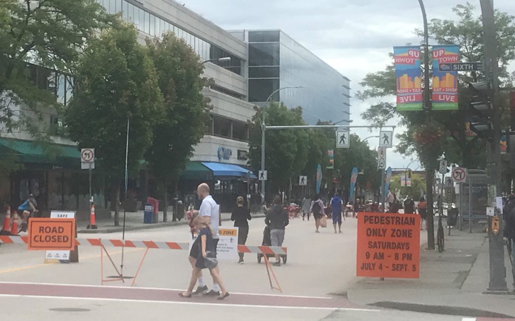
Early on, there was some rapid work to address pedestrian and active transportation “pinch points”, especially in the Uptown and on a few Greenways. The city was able to quickly create more safe public space downtown by re-applying the weekend vehicle closure plan of Front Street that we already had experience with. Uptown, the BIA asked the City to allow temporary weekend-only opening of some street space for lightly-programmed public space. Response has been pretty positive:

There is a bit of push-back on these interventions, as there always is when status quo is challenged in the transportation realm. Predictably, the traffic chaos, accidents, parking hassles and general mayhem that was predicted by more vocal opposition just didn’t occur. Staff is tracking actual data, but I have made a point to visit these areas often (COVID and working from home has made me into one of those walking-for-recreation types) and have been collecting admittedly anecdotal views of how these sites are working.

There are two more ideas that are being launched for the second half of the summer, and I want to talk about them because they came from different directions, but ended up in the same place, and are also eliciting some public comments right now (as was the intent!)

The City is piloting a “Cool Streets” program that identifies key pedestrian routes in the City for light interventions to reduce the through-traffic load and give pedestrians more space to stretch out. The way these streets were identified for the pilot is what makes this interesting, and speaks to one of my previous lives when I was briefly a GIS geek.

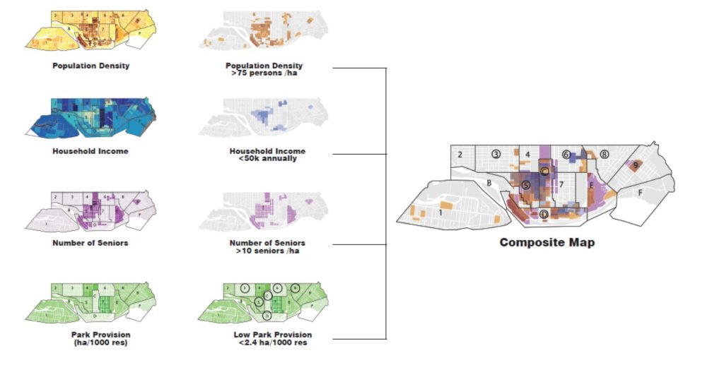
The goal to identify areas of the City where more vulnerable people have less access to green space, shade, and safe waling/rolling routes to parks and services. The approach very much aligns with the City’s Intelligent City initiative by using data-driven analysis to help make decisions. The City used its Geographic Information Systems (GIS) data set to identify areas that met the following criteria: higher population density, lower household incomes, larger proportion of seniors, and lower parks space per capita. Using GIS to “overlay” these layers, they identified area where many of these criteria overlap:

Once the “dense” areas of this map were identified, staff went through looking at the routes that combine connectivity to key destinations (parks and services), where grades were lower and where the most tree canopy cover was available:

They then identified priority routes for “green street” interventions (1, 2, and the west part of 3 in the map below), and extended these along streets that get to key destinations (the east part of 3 and 4):

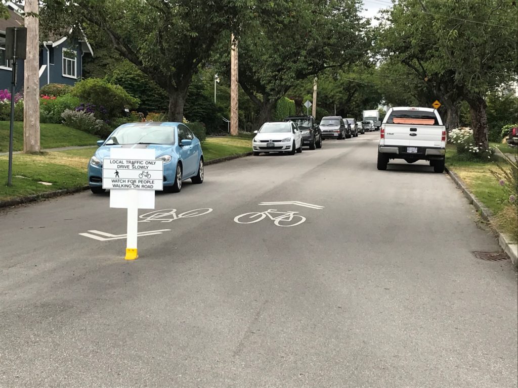
The interventions here are very light. The roads are not “closed” to cars, but are calmed using ideas drawn from experiences in other cities from New York to Oakland to Toronto to Vancouver. The hope is to create truly traffic-calmed streets where local access by car is still available, but the space is open for people to share and program as they wish. Local streets acting like streets for locals, not as through-fares.

A second initiative was led by a community group in Sapperton. Concerned about some recent close calls on the part of the Central Valley Greenway that runs through lower Sapperton, they surveyed their neighbours and brought a proposal to staff asking if a pinching down of one block of the greenway could be trialed in light of the Streets for People motion. Again, the road is not closed, but signage was installed to discourage through-traffic and removable soft barriers installed.

Both of these interventions are temporary pilots. They cost very little to put in action, and provide valuable data to our transportation planners, while also giving the public a chance to see what changes would look like before we invest in more permanent or expanded road re-allocation.

In her great book Street Fight, Jeannette Sadik-Khan talks about successes in urban residential areas where more local and lower-key interventions like this have occurred. A major part of this is trying some things (lightly, quickly, and cheaply) as a form of consultation and data collection. This allows us to get past the baked-in institutional resistance to change that says everyone has to agree on paper before we even try the most minor change, and before we can test whether a change is a net good. The Summer Streets program in New York was her model of this – feared by many, embraced by almost everyone once implemented, with the fears proving unfounded in the long term.

All that to say, these light interventions are designed to elicit not just public participation, but public feedback. And I have received feedback already. I’ve received e-mail form people very upset that they were not consulted; e-mail form people predicting traffic chaos; and e-mail from people asking if they can do this on their street. My short answer to those questions are, respectively: this is the consultation; the sites selected were local streets, not traffic-challenged throughfares, but staff will be collecting data to assess the impacts on traffic; and not likely this year just because of timing, but if things go well, I hope these kinds of pilots can be expanded in 2021.

So, if you like this kind of intervention, let us know. If you don’t, tell us why. Staff have included in the analysis above other priority areas for Cool Streets that may be implemented in the future, including Downtown and the McBride commercial area in Glenbrooke North. As for the community-driven version, if you would like to see this type of intervention as a temporary or permanent feature of your street, start reaching out to your neighbors (maybe hold a social distance block party?) and talk about it. If you can gather enough interest, maybe the City can make something happen in 2021.  To me, local communities reclaiming space is a major part of making Streets for People again.

ASK PAT: Brews & Patios

Wes asks—

Why can’t a brewery get a non-temporary patio in New West?

Has anyone in city hall ever been to Portland (or even Port Moody)? Every brewery literally gets rid of their parking lots and replace them with picnic tables and umbrellas.

They can. It is a bit hard for me to answer this question directly, because there are only two breweries operating in New West, and that makes it challenging to talk  about general City policy without uncomfortable references to specific cases. This is probably not the appropriate medium to talk about specific sites when those are private small businesses in the City. So I’m going to try to make this as general as possible to be fair to those owners.

Yes, I have been to Portland. I know most other members of Council have been to Portland. Some even attended the Livable Cities Conference there last year and have brought back ideas to make New West weirder. There are aspects of the Portland streetscape that the Mayor can’t stop extolling. I’ve also sipped beers on sunny patios around the world, from Montreal to Hue to Lesotho to Cologne. I’ve never heard of Port Moody, though.

New Westminster has allowed patios for the three main categories of food and beverage businesses (Food Primary restaurants, Liquor Primary pubs, and Manufacturer breweries) for some time , and many of them across the City have patios. However, the City is not the only regulatory body involved in licensing these spaces, and often there are complicating details between City zoning bylaws, provincial liquor licencing, and a variety of other rules that apply to businesses, especially the strange amalgam of light industrial activity and hospitality that is represented by breweries with tasting rooms.

I can’t talk about how it works in Portland, because I have no idea how their regulatory regime works, but I’ll try to outline my understanding of the local regulatory environment while avoiding any direct reference to any specific businesses.

In pre-COVID times (when this question was asked, and yep, I’m slow with answers these days), the City had a Sidewalk Cafe policy, guidelines, and a process in place to approve said patios, and on-site patios (those that are on private property of the pub/restaurant) were permitted in all commercial zones in the City. Sometimes a zoning variance would be required to change parking use to patio use (as amount of parking is regulated by zoning), but there was a process to do this, and I don’t recall Council ever saying no. There would also have to be an expansion of the liquor licence, which is provincially regulated and comes with requirements around access and fencing and such, because non-drinking people in BC must be strictly separated from drinking people or else… uh… chaos, I guess.  There are some other details that may be City Zoning or may be Building Code that can get in the way: for example, the patio has to be accessible (ramps less than 5% grade, 2m wide access points, etc) or number of washrooms and accessible washroom consistent with the occupancy of the room, but again those details can usually be worked out.

If the above require zoning variances, then that may trigger a need for some sort of public process – a public consultation or Opportunity to be Heard, and this makes sense. If you live next door to a restaurant, and they decide to put 50 guests outside making noise until 10:00pm every night, you may have concerns with that above and beyond and concerns you may have had, and it is only fair that you have an opportunity to bring those concerns to Council. Of course, Breweries are generally in industrial areas where this is not as much of a concern.

Finally, if a business wanted to put a patio on City land (the sidewalk, a public parking spot, etc.) then there is another step around the need to licence public space for private use. They need to pay a licence fee, there are insurance and liability issues to clear up, and the City has to decide if there is a public benefit served by this use of public land. Again, this all sounds like a hassle, but it is important when allocating public resources that it is guided by some kind of policy or at least a transparent set of principles and to assure transparency, fairness, and (frankly) accountability.

We are now in COVID times, and things have changed. Most notably, the Provincial Government has made some changes to how patio spaces for business with liquor licences are regulated, in an effort to support recovery for these businesses. The changes will allow near-immediate licencing for “temporary” patios to the end of October as long as it doesn’t increase the overall occupancy capacity of the business (which makes sense, as physical distancing requirements are making it hard or businesses to fit their occupancy limits inside). By doing this in a temporary way to the end of October, it gives business a chance to get going right now, and time for them to get more permanent plans in place if that is the way they want to go.

At our last Council Meeting, New Westminster Council made some changes to our zoning bylaw to further support these “temporary” applications, and further established some strong policy guidance to give staff the clear direction that we want to support the opening of patios asap. This sounds a little self-congratulatory, but in reality, City Staff did a great job putting together the documentation, providing clarity about the rapid changes in the regulatory environment, and bringing local business associations onboard with a regime that works for them. This guidance document shows the straightforward pathway to opening a patio in time for this summer’s patio season.

This effectively kicks the ball down the road to the end of the 2020 patio season, but it also gets patios up and running ASAP, and gives us time to get things in place for more permanent changes. As a bonus, and also gives us a chance to “try out” a process and see what works or where the process needs adjustment, which is really the most effective form of public consultation.

Pool Pause

One of the bigger items on the Agenda this week was the update on the Canada Games Pool replacement project. There were two items, and because of the size and scope of the project, there is significant public interest in the plans, so it is worth unpacking the decisions a bit.

The first big news is that the City was not successful in securing an Investing in Canada Infrastructure Program grant for the Project. This is pretty disappointing, as the City has spent 5 years developing a program around this grant process, and specifically designed aspects of the project to assure we had the best chance of receiving some funds. We did the hard public-consultation and program-design work to get a fundable program that met what we considered all of the possible criteria for the Community, Culture and Recreation category. Our application was submitted in January 2019, and we received notice more than a year later that we were not successful.

Exacerbating this disappointment is that projects for this Grant must be “shovel ready”. This means we needed to be ready to go, with a well-developed project, public buy-in, secured financing (ironically, you need to prove you don’t need the grant to get the grant), and all of the hoops jumped through to get ready to dig a hole… but you cannot yet be digging the hole. If you start digging, you are no longer eligible. I think our staff were pretty creative in getting shovel ready in time for grant application, but were still able to get some detail design and site preparation work done during the unexpectedly long waiting period. However, we clearly lost time in the wait, which is unfortunate.

The nature of the grant program is such that there is no clear explanation from the selection organization of why the project was not selected, except to say that there were significantly more applications than available grants for all of BC, and ours didn’t make the cut. There is another phase of ICIP launching in the fall of 2020, and we may be able to re-package parts of the project to apply for grants then. Also, as both the Province and Feds are signaling significant stimulus funding will be rolling out in the Fall as part of COVID recovery, we have some innovative aspects of the pool project that we think may be successful at getting some support. However, we need to recognize that these will be relatively small contributions, and the City of New Westminster is going to have to pay for most of this project on its own.

Last year, Council had some discussions about the financial plans around the pool, and decided that the larger “Enhanced” pool plan that some in the community were asking for was outside of our financial comfort zone unless we got a significant ICIP contribution. With this confirmation that those funds are not coming, we are taking the “Enhanced” pool off of the table. We are now concentrating on the two-tank (8-lane 50m pool model with a second recreation pool) plan that came out of our extensive community consultations and serves community needs, and is still significantly larger than the existing Canada Games Pool, but not the 10-Lane pool that some in the regional competitive swimming community would have liked to see built.

New Westminster is a City of 71,000 people in the centre of a Metro region with 2.5 Million people. There is a need for a refreshed swimming and recreation facility to serve our growing community, and we also have a myriad of other spending priorities and infrastructure that needs updating. I believe that building a facility for the regional competitive swimming community needed regional support. If we want to build a facility to host Provincials and inter-provincial competition, the senior government grants we applied for were the process available to us to fund that type of facility. Without those funds, we need to concentrate on addressing the pressing community need in a way that fits the financial capacity of our community.

With the detailed design decisions made, and the financing worked out, the next step in the process is to hire a construction company by issuing an “Invitation to Tender” to the construction market. We are ready to do that now, but it opens up a bunch of financial implications for the City, so Council decided to pause a few months before we take this big step.

This is not an easy decision, just as the decision to not build the larger pool is a difficult one. But both were made for similar reasons – concern about the impact on the City’s finances. I know political hay-makers love to cast this Council as spendthrifts because we like to do things that make our City stronger and more livable, but my experience in 5+ years on Council is that we are always cautious when projecting out future City finances, and are pretty risk adverse if we don’t fully understand cost implications.

This is the biggest single capital project the City has ever undertaken. We have been putting some money aside for a few years, but will still need to debt finance the bulk of this project. At the scale of this project, any risks can have a big impact on the City’s budget for years to come. Unfortunately, there is significant uncertainty in the City’s medium-term financial status due to the COVID crisis, and in the construction market due to supply chain concerns and disruption in global markets. For that reason, we are not taking the next step in sending this out for tender until at least the end of the summer, when we have a better handle on the financial status of the City, of the Province, and of the world economy, and the construction market will hopefully have a better handle on costs.

This is acting with an abundance of caution, as I think we have to when talking about an infrastructure investment this size and a financial crisis of this unprecedented nature. The news coming out of the Province and the Bank of Canada is generally positive about recovery, but still really uncertain. If better financial certainty puts us in a position to pull the trigger at the end of the summer, this delay will add only a couple of months to the final delivery date in 2023. However, if the local and/or global financial situation goes very badly in the next few months, we will be much more prepared to manage that as a City without a $100+ Million project weighing us down. Let’s hope it is the former, and we are able to go to tender in the fall, but at this time a pause is the prudent, if disappointing, thing to do.

Streets for People

I had a motion on the Council Agenda on Monday, which I said I would write about later. First the motion in full, then the rant:

Whereas the City of New Westminster established a Bold Step target to re-allocate 10% of automobile-only space toward sustainable transportation and/or public gathering use by 2030; and
Whereas the COVID-19 pandemic has resulted in significant shifts in the use of public space, and “physical distancing” directives exposed the critical need for greater and more accessible pedestrian, active transportation, and public gathering space in the City; and

Whereas the recovery phase of the City’s pandemic response will put tremendous pressure on the City to address these inequities in public space, to assure that the freedom to move about and be active in public spaces not lost, and that our commercial districts are supported in finding creative ways to activate sidewalk and road space to excite customer support; and

Whereas urban areas around the world are currently demonstrating a commitment to reclaiming roads by rapidly converting automobile-only space to more equitable uses that better support neighborhood livability, commercial district viability, community resiliency, and public safety during the crisis and into post-Pandemic times;

Therefore be it resolved that:
The City of New Westminster move quickly in 2020 to expand road re-allocation toward pedestrian, cyclist, and public gathering space, using temporary measures where necessary with a mind towards more permanent solutions that can be applied after the period of crisis has passed;

And be it further resolved that:
The Transportation Task Force make rapid reallocation of road space a priority work item, are empowered to immediately apply temporary measures in 2020, and accelerate the timeline towards the 10% space reallocation goal set out in Bold Step 7 of the City’s Climate Action Plan.

In a rapidly growing city, the need for our streets to be public spaces where people can walk, shop, even recreate – as opposed to merely roads for the purpose of automobile throughput – has never been more clear. Intrinsically, we knew this all along. Every time we have opened up space for people to use at a human scale, people show up and take advantage of that space. When that space is lost again, we feel the loss. Yes, I’m talking street festivals and parades, but I’m also talking about the temporary closure of the east part of Front Street that brought people to use that space creatively for a summer, and the small calmed or reclaimed areas like the Front Street Mews and Belmont, or the pedestrian space reclaimed on McInnes.

Along comes a pandemic, and all of the sudden commuter traffic has reduced, and people are using space differently. People have shifted to walking more, there are noticeably more youth and families out on bikes, and the way we shop and assemble and queue use transit has changed. With people spending more time working at home or (alas) unemployed, there are more people outside using public spaces. Gathered in parks in small virtual pods of a few people, spread across the space. People want to be outside, but people are wary of being too close or crowded in public space. The only solution to this math is: more public space.

The City has reacted in some rapid ways to support these changes in the transportation realm. The report we received in the May 11 Council package outlines much of this: fixing the pinch point on the Central Valley Greenway at the north end of East Columbia, asking people to use the Quayside esplanade differently, making more space for safer use of the McInnes Overpass. And the obvious happened: every time we have opened up space for people to use at a human scale, people show up and take advantage of that space.

At the motion says, New Westminster has already set a goal to re-allocate 10% of road space by 2030 as one of our Bold Steps towards Climate Action. In light of current events and the radical change in the use of public space we are already seeing, the 2030 timeline no longer feels bold. In a city with as much road and as much pressing need for public space right now, we need to act faster.

And we are no alone in this, Cities from Vancouver to Montreal to London to Seattle have shifted the use of street space to make pedestrians, cyclists, and other street users more comfortable and safer.

New Westminster has a lot of road space, an excess of road space in many ways. We can demonstrate regional and national leadership not by changing our plans, but by simply re-setting the timeline for this work – the immediate shift of road space by temporary measures – paint, no post barriers, planters, delineators, and bollards. We can aggressively do this in the summer of 2020, with a mind to making these re-allocations permanent as capital budget and recovery allow.

My motion calls on us to do the things outlined in the Staff report, and more, and much more rapidly. Additionally, as much as I appreciate the great work transportation staff have done so far, I want us to also think about how we take this work out of the transportation realm, and expand it to thinking more holistically about how we can re-allocate space to support our business districts, support the arts community, support people finding new ways to connect socially while distancing physically, how the re-use of public space will be a keystone to the recovery from this crisis.

The summer of 2020 is going to be different. And coming out of the Pandemic, there will be transformations in how we live in our City. If we are bold and brave now, we can shape those transformations towards the more people-focused, more equitable, and more sustainable community we envisioned in our long-term planning. Like so many other needs in the community, the COVID-19 crisis did not create this need, but it did demonstrate the urgency of the need, and provides the opportunity for accelerated action to address the need that was always there.

I want this motion to be the start of a conversation – but getting mired in debate about priotization and compromises is the biggest risk to us actually getting change during this critical time. I will be talking out a lot in the weeks ahead about this, and I want to hear form the community about the visionary changes you want to see in your community, in your neighbourhood, on your street.

I want to see rapid deployment of greenway treatments to finally address some of the gaps. I want to see expansion of sidewalks into car storage spaces so that people have comfortable space to walk in our commercial areas, and so our commercial businesses can be supported as they re-open by taking patios or merchandizing areas out on to the sidewalk. I want to see small chunks of our local streets closed to traffic and converted to active use for neighbourhoods that are going to be itching for social connection during a summer with no festivals. I want every student to have a safe route to walk or roll to school. I want us to stop laying pavement expanses on parts of roads that don’t facilitate safe speeds or safe crossing. And I’ll be going on at length about these things…

I wrapped my little speech at Council by quoting Gordon Price – the former Director of the City Program at SFU and City Councillor for the City of Vancouver:

Reallocation as a health response, a climate-emergency response, a neighbourhood planning response, and an active-transportation response – all of the above at a time when the difficult-to-do has become the necessary-to-do.

Because it is time, because it will make us a better City, let’s do this.

Budget 2020!

This week in Council we are going to be talking about the Budget, and are asking people to once again provide us some feedback on budget issues. Providing this feedback is difficult for many people, or it is hard to understand how your feedback will be incorporated, because municipal finance is a little bit arcane. So I thought before the meeting, with the reports and tables on line here, I would give you a bit of a run-down of how the budget process works.

We have already had some lengthy discussions about the capital budget. This is the budget we use to pay for things like buildings and vehicles and computers. These are (mostly) one-time items, though most need periodic replacement, and (mostly) tangible objects, though we can use capital funds to fund planning for tangible objects, like hiring a consultant to develop an Urban Forest Strategy that will result in capital expenses to buy and maintain trees.

The City is required to balance its budget over a five-year financial plan, so when we talk about “Budget2020”, we are talking about an excerpt of the overall 2020-2024 Financial Plan. Following from this, our 2020 Capital Budget is part of a 5-year Capital Plan, which makes sense because most large infrastructure works cannot be planned, financed, completed and paid for in a single year.

Our draft budget has a 5-year capital plan to spend ~$468 Million on new buildings, infrastructure and equipment, with a some of that representing a few major projects: The ~$100M Canada Games Pool, $54M for a district energy utility, a ~$40M electrical substation in Queensborough, ~$17M to fix up the Massey Theatre, $20M in road paving, etc. This includes the Utility capital investments ($123M for Electrical, $50M for Sewer, $25M for water, and $1.6M for solid waste). In 2020, we are budgeting to spend ~$140 Million of that total.

The City has three options to pay for any capital expenditure: reserves, debt or revenue. Reserves are the monies we have in the bank, some to assure financial solvency, some earmarked specifically for projects, like the money we have put aside for the Canada Games Pool replacement. If there is a reserve fund appropriate for the spending we plan, then drawing from those reserves make sense, though we have to be cautious about drawing those accounts too low because they provide us some financial resiliency, and improve the rates we get from banks when we borrow. Borrowing to pay for infrastructure makes sense for a recreation centre much the way it makes sense to get a mortgage for your house: the people using it pay for its use while it is being used. We have a *lot* of debt room in the City as far as regulations and good financial planning are concerned, but we have to address the public tolerance to take on debt (through a public process when we take out loans), and of course manage the cost of borrowing. The third option is to draw from revenues in the year we have the expense, be those revenues in the form of a grant from senior government or through raising taxes. These both, of course, have limits.

The part of the annual budget that directly impacts your tax rates is the Operational Budget. It is from this budget that we pay staff and buy paper and diesel. Sometimes a pundit in town will chagrin “most of the City’s spending goes directly to salaries!”, to which my only retort is “Yeah, and?” The City provides services more than we build widgets. Widget ore is not as big and expense as delivery of those services, which are delivered by people, from lifeguards to librarians to police officers. Sure, we buy asphalt and pipes, and firefighters need firetrucks, but most of our budget is service delivered by people.


We spend most of the year operating the City based on the operating budget set in the previous spring. As the year goes along, staff, Council and the public identify places where the City can do things differently, where our service is not meeting demands, or where new services are being pondered. Some small things may get done as staff find space in their existing budget to make them happen (or stop doing other things to make the room). But some things are more costly or need more staff time to manage, so managers put forward an “enhancement request” – they ask for more money.

Part of the task of our senior management team is to review all of these enhancement requests, and decide what is reasonable and what isn’t, then set some priorities. Council is not directly involved in that process, but the priority-setting is based on a framework of Strategic Planning created by Council. One of the questions staff need to ask themselves and each other at this stage is – does this enhancement meet a strategic goal of the Council? Then ask if we can afford it. Which is where Council comes in.

Before these enhancement requests, the draft 2020 budget sees costs equaling a 3.9% tax increase already baked into our 5-year financial plan. These are things like increased debt servicing, annual salary increases, inflationary pressures and financing of earlier enhancement commitments already made by Council in previous budgets. Staff have brought forward new enhancement requests equaling just under another 2% of taxes. They then recommended that about half of these enhancements be included in the 2020 budget, and the other half deferred to a future year. This equals out to a draft 4.9% tax increase.

There is an interaction between the Capital and Operational budget. The interest we earn on our reserves is a revenue that is included in our operational budget, so draw those reserves down and we have less revenue. Similarly, the interest we pay on our loans is an operational expense. There is also an operational impact to many capital projects: the NWACC will cost money to heat and light, and will need to be staffed. It will also bring in revenues. Those numbers will be different for the NWACC as they are for the current CGP. These changes have to be budgeted towards.

Since we have a regulatory requirement to balance the budget at the end of the year, if we pull in more revenue (through taxes, charges for services like parking and permits, grants from senior governments, investment income, etc.) in a year than we spend (on salaries, supplies, grants, etc.) that extra money (“profit!”) goes into our reserves and helps offset future capital budget costs. The corollary to this, of course, is that a large capital budget requires us to raise taxes a bit to keep these reserves at a stable level and to pay debt servicing costs.

(I have almost completely skipped utilities in this discussion, I talked a bit about them, with fancy coloured diagrams to show how those work in this blog post from a couple of years ago)


So, this week Council will be asked in two meetings (Monday AND Tuesday nights) to review the budget, review the results of the public consultations that occurred around the budget, and provide one more public meeting where people can come and address council with their concerns regarding the budget. We will review the capital budget commitments for 2020, and will review the recommended and non-recommended enhancements. Council will then make recommendations on any changes, and staff will take those away and work on putting together the necessary Bylaws to make the budget a reality. By the end of the Tuesday special meeting, we should have a pretty good idea what our budget increase will look like for 2020, but looking at the reports, it will likely be something around 5%.

Metro2020

Last week during our afternoon workshop, New West Council received a presentation by representatives of Metro Vancouver’s Regional Planning Services. They were here to talk about the upcoming update to Metro2040, the Regional Growth Strategy, eloquently labelled Metro2050.

The Regional Growth Strategy is the highest-level planning document in the region. All municipalities have some form of master planning document, be it an Official Community Plan or a collection of Neighborhood Plans that lay out in broad strokes what the vision is for the community over the decades ahead. This is important, because it allows government and utilities to plan new roads, water and sewer lines, recreation facilities, emergency services, schools, and all of the things that should, ideally, be planned out before they are needed. It also helps guide policy assures communities have the right mix of housing types, commercial and institutional land, and green space. Without a well-understood plan, we cannot develop the robust policy needed to shape the outcomes we are looking for.

All the municipalities in Metro Vancouver agreed upon and ratified the Metro 2040 plan back in 2011, and all of our subsequent Official Community Plans (including the OurCity 2041 plan adopted by New West in 2017) include a context statement that links it to the greater regional plan. This is because all of the things I listed above (roads, utilities, etc.) need to be planned at a regional level if we hope to have a livable region. Every community shares our regional sewer system (for example), and the growth of the region relies on significant investment in new sewer infrastructure – not just pipes in the ground, but billions of dollars in wastewater treatment plants that need to be planned out a decade or more in advance. To make that work, we need to know where the houses, the apartments, the breweries and the shopping malls Amazon Fulfillment Centres are going to be when that plant is operating. That’s the essence of planning.

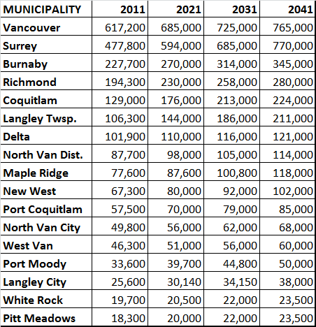
As we start looking at Metro2050, I wanted to get an idea of how we were doing on Metro2040. One of the easiest things to evaluate looking at that strategy is how growth was distributed across the region. If you look at Appendix A of Metro2040, you see population growth projections for the region by decade:

This is an extract from the Metro2040 plan, I removed a few of the smaller municipalities like Lions Bay and Anmore because they account for less than 0.2% of the regional population, and though they are certainly beautiful communities full of wonderful people, their growth trends are irrelevant to the regional picture.

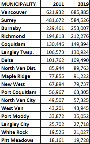
As we are now almost a decade in, and are doing an update, I thought it might be useful to see how these projections turned out. Unfortunately, the best source for annual population estimates is not the Metro2040 Plan, but the annual stats collected by the Province (you can see them here), and they do not correlate perfectly with the Metro Numbers. Here are the BC Population Stats for 2011 and (most recently) 2019 for the municipalities above:

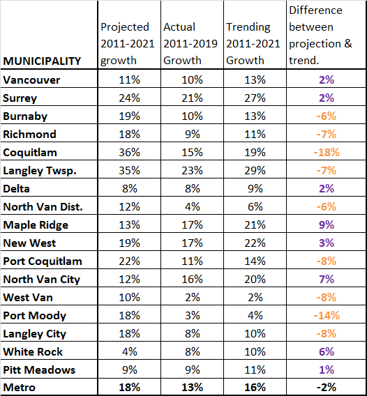
The numbers are not exactly the same as the Metro estimates, but we can compare the two sets by looking at the projected total growth (2011-2021) as a percentage of the 2011 population from Metro, and the estimated actual growth between 2011-2019 from the BC Government stats. Since that growth only includes 8 years, I projected forward two more years at the same rate of growth for each community – so which communities are on trend to meet their 2011-2021 estimates? The numbers may surprise you:

As you can see, the projected rate of growth of the Metro region over the decade was 18%, or about 1.7% annually. The actual growth from 2011 to 2019 was closer to 13% (or little over 1.5% annually), and if you project this trend forward to 2021, you get 16% growth. We over-estimated slightly.

Using the same baseline, you see vast differences around the region when communities are compared to their goals. White Rock, North Van City and Maple Ridge all grew much more than their projections, while Coquitlam and Port Moody were anomalously lower than their projected growth. Of course, this is compared to their projections, as Langley Township grew 7% less than projected, but was still the fastest growing municipality in the region at 29% growth, where Delta was one of the slowest-growing communities at 9% over the decade, but still exceeded its meagre growth projection.

There are, no doubt, local reasons for these trends. The fact the two newest communities in the SkyTrain family (Port Moody and Coquitlam) are the ones that lagged farthest behind may be related to how far behind projected opening the Evergreen Line was. Coquitlam seems to be catching up with significant growth around their new stations, though it seems Port Moody is on a different path. It is also interesting, if anecdotal, that many communities that had the most growth-related angst through the 2018 local elections, like White Rock, Port Moody and the District of North Vancouver, have some of the lowest actual population growth numbers. Having population growth rates of less than a half a percentage a year in this region is an anomaly worth exploring deeper as we look forward.

There is more info about the Metro2050 process, and ways you can get engaged here at the Metro2050 page. C’mon out, tell them what you think.

Year of the Beard

I’ve been taking a serious year-end break. I took a couple of weeks off work, got out of town just after the last Council meeting. I’m taking a social media break as well, though I do hazard a short lurk once in a while to assure myself #NewWest still exists. I brought a few City documents on the road with me, and I am spending a bit of down time reading capital budget stuff (January is coming on soon!)but it’s been nice to turn most things off for a bit, ride my bike, sit on a beach, and chill with @MsNWimby.

That said, the week between Christmas and the New Year is ripe for these “year in review” things, so here goes mine. 2019 was a strange and interesting year, and I have a hard time summing my 2019 up.

One big change for me personally in 2019 is a change in my work/life balance. I went back to more regular “work” outside of Council. When elected in 2014, I was working full time. After almost two years of increasingly strained attempts at making it work, I had to be honest that I was not giving the attention or energy my 40-a-week professional job deserved, and decided to quit. For the balance of my first Council term I was doing a bit of consulting work, but nowhere near full time. Being honest about the effort and time I could put in with this council work (and my volunteer work with the CEA, CSAP, and LMLGA), I had found a couple of clients that offered the right level or workload, though I think @MsNWimby would have liked a more equitable contribution to household expenses.

In early 2019, I had an opportunity to take a real job working in my field that was half time – a solid 20 hours a week at a proper professional wage. It is work I am very familiar with so the learning curve was easy to get past, and I was able to provide value right up front. The employer is super flexible, and we have a great relationship around planning a work load for the weeks ahead, so I can assure scheduling conflicts are avoided. It all seems very “millennial” in work conditions, but it is working for everyone, and I am staying connected in my field. It has been a fun team to get to know as well, and the work is really interesting. so all’s good!

I also spent a bit of time in 2019 volunteering on the local federal election campaign. This was mostly a good news story – Peter Julian is an easy Member of Parliament to support, he had a great team working for him, and it is fun to knock on doors and make phone calls when you are stumping for such a popular guy!

The disappointment side of the 2019 Federal Election, personally, is a regret that I didn’t spend more time over in Coquitlam/Port Moody helping Bonita Zarrillo’s campaign. I have known Bonita from local government stuff for a few years, and was really excited to hear she was going to represent the NDP in Fin Donnelly’s riding. She is passionate, smart, caring, and hardworking, and she loves her home in the Tri Cities. In the end, she lost a squeaker to a parachuted-in ultra-conservative who failed to meaningfully campaign when she arrived. To see such a brilliant local leader lose to a party-issue hack form central casting is sad. To me a Member of Parliament is representative of your community in Ottawa, not a representative of the Party in your community. I feel disappointment that I didn’t have the foresight to invest more of my volunteer time to help Bonita, when she just needed a few hundred votes to get over the top. Sorry Bonita, but I am glad we are still working together in Local Government in the Lower Mainland.

In the local political realm, New West Council had probably the most quietly challenging year I have ever experienced. From my seat, it seemed there were very few big splashes, yet we pushed some really bold stuff forward. I have felt a tremendous amount of personal growth in how I approach the work, and the organization’s growth in some of the functional changes we are making at City Hall and in Council Chambers. We are making the organization more efficient and effective, though some of this is a bit out of sight for all but the vigilant council-watcher. This is alongside the real progress and growth reflected across the organization on files like climate and reconciliation. I think our Strategic Plan is (perhaps) too aggressive in wanting to achieve much more in a short time period than will be easy for a City our size. That said, I can’t disagree with the bold vision created, and hope we can continue to build the political will to be the most progressive and forward-looking local government in the province, if not in Canada. The shift represented by our Council and Staff’s embrace of aggressive climate actions is an encouraging example of progress that can be made when we are all on the same page, and I’m glad this community is still pushing us forward on that front.

In looking back at the direction we are forging, I find myself using words like “aggressive” and “bold”. Still, it feels like we are being given the clear political push from the public to get this work done. The community is telling us they can be just as bold as this Council, and perhaps through us providing transparency and a clear set of underlying values and vision, I am more confident in our ability to make this progress.

It is a bit funny, but you sometimes need to go outside to see how good things are inside. Our Council has ways of disagreeing – even new ways different than the last Council –and can drive each other nuts with our 7 different ways of approaching solutions, but if our paddles sometimes cross, we are all at least rowing the same direction. It is mostly at regional or provincial conferences where our cohort reminds us that New West is functional and punching way above its weight in the local government actions, and we do it while avoiding so much of the hijinks afflicting other less-functional Councils around the region. They get headlines, we get work done. That is a good feeling.

2019 had challenges, but I think the year ahead will be more challenging. We are deep into Capital Budget discussions right now, and are asking for the public’s help in setting those priorities. Translating an aggressive capital plan into a sustainable operational budget is the hard work part. We will be having some conversations not just about the things we want to do, but our vision for the 5 years ahead is going to have to include some conversations about what we are not going to do, or are going to stop doing. And New Westminster is not as good at letting things go as we are at starting new things (and by that I mean Council, City Staff, and the Public!). These conversations will be at times hard, but worth while. I’m looking forward to the work!

With all of this going on, I hardly had time to ride my bike for recreation, my blog here has been suffering from lack of attention (but blogs as a media are deader than dead, so who knows the future of this?), and my garden was a pretty dismal failure, except for all the tomatoes. I also found myself intentionally stepping back a bit from some things in 2019, mostly because of my new work & commuting schedule: fewer of those “I should make an appearance” events, and less patience for social media. I’m not sure what to make of my nascent impression that our local political challenges have become pettier, despite the good work we are doing (see above). I am not sure if that is a product of the changing social media landscape, or just the natural result of me settling in after five (5!) years of elected life. Or maybe I’m getting older.

Which brings the big personal news – I turned 50 in 2019. I’m not sure how that happened, but it just kinda snuck up on me and now I am looking down the second half of middle age. @MsNWimby threw a hell of a party, and I really haven’t taken the time to thank everyone who came out to celebrate. 50 makes you ornery, I guess. Or gives you a ready excuse to be so. Thank you for the great party, and for being a great support network for me and @MsNWimby.

Let me wrap my 2019 in review by thanking the wider network of great people in New West working to build this unique, progressive, compassionate community. There are so many people in this town who are doing so much to make it a great place to live. My Council colleagues are constantly challenging and surprising me, and the Mayor has really grown into a strong leader who earns more respect every day. There are true leaders in the School District, in the Arts community, in our BIAs and local businesses, in the many service agencies that make New West tick. Please keep up your good work, though it may feel you are fighting against the tide, your contributions are noticed and appreciated. If I have one resolution for 2020, it will be consciously spending less time worrying about the boo-birds on Facebook, and more time expressing gratitude to the many people around New West actually working every day to make this community so great. Happy New Year!

Trip Diary 2

In my recent post about the TransLink Trip Diary data release, I talked about how the use of cars in New Westminster is going down. Even as our population grows, the number of people using cars to get around is stable, and the actual number of car trips generated by New West residents on the average day is going down.

I also wrote this does not mean there are fewer cars on the road, or that traffic is getting better, because New Westminster is in the centre of a connected region, and that region is growing. Unfortunately, New Westminster’s decrease in car use is not being seen across the region, and our roads and livability are being  impacted by those trips generated mostly from the south and east of us.

All but three municipalities in the Trip Diary data had an increase in car trips, and the combined number of regional trip increased by more than half a million trips a day between 2011 and 2017. This is only slightly offset by the combined decrease in trips seen in New West, West Van and White Rock:

There are a couple of other ways to look at this data, using percentages instead of raw numbers. If there are 520,000 new car trips across the region, this pie shows the percentage of that total traffic load that is generated by each municipality:

So no surprise Surrey and Vancouver lead the way in new car trips, as they are the largest municipalities, nor is it surprising that 50% of the new trips are generated South of the Fraser, and most trips are generated in areas where the region has spent billions of dollars building new freeway infrastructure and new river crossings.

But what about population growth? The South of Fraser an northeast communities are growing fastest, so it makes sense that their car trips will increase in correlation with this, right? More people = more trips is the meme I challenged last post, and it clearly is not the case for New West, but how true is that across the region? The blue bars here represent the percentage increase in car tips between 2011 and 2017, and the red bars represent the population increases over the same time period (2011 – 2017) from the BC Government stats page:

Note that in almost every municipality, car trip numbers are increasing at a faster rate than population. In Port Moody and North Vancouver District – two communities where the councils are using increased traffic congestion as a reason to slow or halt new housing – actual population did not significantly increase over that 6-year period (the fact they show a slight decrease in population is quirk in how BC Population stats are estimated between census years), yet this did not prevent car trips increasing. The short point:

Car trips and resultant congestion do not correlate with local population changes.

I leave you to speculate about what is happening in White Rock and West Vancouver, two municipalities where population has been stagnant or decreasing for a decade, and neither specifically transit-oriented relative to those of us sprinkled along the Rapid Transit spines, but both seeing much reduced car use. Each has its own tale to tell as West Vancouver had a significant increases in walking and transit use to balance out to about the same number of total trips, while the entire trip count for White Rock across all modes went down significantly. This graph shows the percentage increase or decease in each mode for all Cities, and you can’t help but wonder what people in White Rock are doing at home all the time: 

Also note the latest data was collected not long after the opening of the Evergreen Line, but before the changes that have come with the Mayor’s 10-year Plan investments, which has brought more and more reliable bus service across the region, both in undeserved and overcrowded areas. It is also worth noting that the 2011 data was before the opening of the expanded Port Mann Bridge, and the 2017 data was from the very time when tolls on that bridge were being removed, so the longer term impact on transportation patterns related to toll removal are muted here. Like all surveys, this represents a snapshot in time, and only by collecting this type of data over a longer period can we see the long-term trends our transportation policy is creating.

Trip Diary

The venn diagram overlap of transportation geeks and data geeks shines brightest when Trip Diary numbers are released. So despite the zillion other things I have to do, I sat down for some Excel Spreadsheet fun this weekend to look at what the Trip Diary data release tells us about New Westminster.

The Translink Trip Diary is a survey-based analysis of how people in Greater Vancouver get around. Unlike the Canada Census that asks simply “How do you usually get to work?” and “How long does that take you?”, the Trip Diary digs down into details about how people get around. What types of trips do they take, where do they go, how far, and how often? The difference matters because many people, especially those who use active transportation modes, use more than one way to get to work and travel for non-commuting reasons as well. I have two jobs, one I either walk or cycle to, the other I either cycle or ride transit (after a 5-minute walk on one end). My “usual” could be transit or cycling or walking, depending on the week. I usually walk to shopping, but sometimes drive. I sometimes drive to recreation, sometimes I bike or walk. For most of us living in a modern urban area, our modes are mixed, and understanding that mix is more important to how we plan our transportation system than the simplistic census question.

I’m going to skip over some of the regional stuff (maybe a later post when I find time because there is some fascinating data in here) to concentrate on New Westminster. All of the numbers below that I refer to as “New Westminster trips” are trips by people who call New West their city of residence – whether their trips start and/or end in New West or elsewhere in the region, every trip made by a New West resident is considered a New West trip.

The last Trip Diary provided data from 2011, and at the time, New West was doing OK as far as “mode share”, which is transportation geek speak for “what percentage of people are travelling by X mode.”

As might be expected for a compact city with 5 Skytrain stations, New West has high transit mode share at 17% of all trips. In 2011 we used transit at a higher rate per trip than any other City in the Lower Mainland except the City of Vancouver itself (at 20%). We also had higher walking mode share than most cities (11% of all trips, which is only behind Vancouver, North Van City and White Rock). Our 2011 cycling mode share was a dismal 0.4%, which was, even more dismally, close to the regional average. Add these up, and we had one of the lowest automobile mode shares in the region. 59% of trips were drivers, 13% were passengers, totalling 72% of trips, which was lowest in the region except (natch) Vancouver. Contrast that with the traffic we need to deal with and the amount of space we have given over to that traffic. But more on that later.

The 2017 Trip Diary data shows how our mode share has shifted over a 6-year span:

As you can see, the shift is subtle, but in a positive direction if you hate traffic. Our transit rode share went up to 20% and is now the highest in the region (Vancouver’s dropped a bit to 18%) New Westminster is now the City in BC with the highest transit mode share! Our walk share went up to 15% and is still 4th in the region, and our bike mode share doubled from dismal to still pretty bad. Or car mode share, however, dropped from 72% of all trips to 64.5%, and “passengers” went up a little bit in share, suggesting that single occupancy vehicle trips went down. Going from 59% to 51% of driving trips in 6 years is (a 14% decrease) is a really positive sign for the livability of our community.

All of those numbers are percentages of trips, but they mask that New Westminster is a growing city. Based on BC Government population estimates (BC Gov’t Local Government Statistics Schedule 201), our population went from 67,880 to 73,928 over that 6-year span, an 8.9% population increase. The trip diary raw numbers show that our number of trips went up at a higher rate: a 12% increase from 194,000 individual trips on the average day to 217,000 trips. We are moving around more. And this is where things get interesting:

With a modest increase in cycling (around 1,000), and significant increases in walk trips (11,000) and transit trips (10,000), there was no increase in trips taken by car – the increase in passengers almost exactly offset the reduced trips by drivers. I need to emphasize this, in bold, italics and in colour, because this is the big story in all of these numbers:

All of the new trips taken by New Westminster residents, as our population grew by 8.9% and our travelling around grew by 12%, resulted in no increase in car use by residents of the City. All of the extra trips were counted as transit, walking, or cycling. Simply put, this logical connection perpetuated by people who oppose the transit-oriented development model, is not supported by the data:

Admittedly, this does not necessarily mean traffic is getting better; That a smaller proportion of people are driving and that driving is becoming less convenient, are not contradictory ideas. Other parts of the region have not seen the same shift, and growth to the south and east of us especially is increasing demand on our local roads. This also means there are more pedestrians and cyclists about, so crosswalks are fuller and taking more time to clear, meaning some tiny amount of through-capacity from cars is lost to accommodate the mode shift and keep vulnerable road users safe. The City shifting resources to serve the growing proportion of our residents that don’t rely on a car every day also makes sense from a planning principle. If I am car-reliant (and some in our City definitely are) I can rest assured that a huge proportion of our public land space is still dedicated to moving and storing cars, and a large portion of our budget to accommodating the expectations of drivers.

But the writing is on the wall, and we need to continue to adapt our practices and resources to reflect the success that is starting to show in our regional transportation numbers.

Bikeways now

We have had a couple of presentations to Council by the reinvigorated HUB Chapter for New Westminster. I have been a long-time supporter of HUB (through membership and donations), used to serve as a community representative on the Advisory Committee for Bicycles, Pedestrians and Transit (ACTBiPed), am now Chair of that committee, and even have my name attached to the city’s Master Transportation Plan as a community member of the Master Transportation Plan Advisory Committee, so I feel pretty close to this issue. I thought it was time to write a bit of an essay on where I think we are, and where we need to be going as a City when it comes to transportation. And it isn’t all good.

I need to start this by interject one of my usual caveats about how everything you read here is my opinion, coming out of my brain (or other internal organs, commonly spleen) and not official communication from the City. I am one member of a Council of 7, and they may or may not share my opinions on this stuff. There are staff in the City doing their jobs with much more engineering and planning expertise than me who may cringe in reading my relatively uninformed take. So nothing here should be taken to represent the thoughts, feelings or ideas of anyone or any organization other than myself.

The same goes for my random tweets that sometimes get picked up by the media. I was recently critical on-line of a change in the BC Parkway along my regular-job commuting route that made cycling along the parkway less safe for cyclists and pedestrians. After getting re-printed, I felt the need to state that I recognize New West has some work to do on this front as well, but I like to hope that despite our being slow at improvement, we are not actively making things worse. It is the pace of improvement that I want to lament now.

I am a little frustrated by our lack of progress on building a safe and connected cycling network in New Westminster. I understand a little more now in my role about why we have been slower to act than I like, but I think it is time for us to stop looking at lines on maps and start building some shit.

Up to now, work on the Master Transportation Plan implementation has emphasized things that I think needed to be emphasized in our transportation space – curb cuts, making transit stops accessible, and accelerated improvement of pedestrian crossings. these are good things that deserved investment to remove some of the barriers in our community that represented some obvious low-hanging fruit. We have also staffed up a real Transportation department for the first time, so we have engineers and planners dedicated to doing this work, and they have been doing some really great work.

We have built some stuff! There are areas we have improved, and though they are better than what was there previously, I cannot believe anyone would look at some of this infrastructure and see it as truly prioritizing cycling, and (more to the point) few of them meet the mark that we should be striving for – All Ages and Abilities (AAA) bike routes that an 8 year old or an 80 year old would find safe, comfortable and useable. As I am learning in this role, each project has its own legacy of challenges – resistant neighbours, limited funding, tight timelines to meet grant windows, unexpected soil conditions. Every seemingly bad decision was made with the best intentions as the least-bad-of-many-bad-options. But we need to do better, and that means spending more on better. 

So, much to HUB’s points, there are a few projects I think the City needs to get done soon, and I hope we can find the capital to make happen, even if they are not as sexy as some region-defining transportation links, they are fundamental if New Westminster is going to take the next steps towards being a proper 21st century urban centre:

7th Ave upgrades The existing temporary protected bike lanes on 7th Ave between Moody Park and 5th Street are getting torn up right now as scheduled water main and service works are happening under that street. I am adamant that permanent protected AAA bike lanes need to replace them. This is the part of the established Crosstown Greenway that sees the most non-active traffic, and is probably the least comfortable part as it also sees its fair share of rush hour “rat runners”. The rest of the Crosstown Greenway could use some enhanced traffic calming, pavement re-allocation, and cyclist priority in some intersections, but it is this 300m section where true separated lanes are the only way all users will feel safe.

Connection to the High School Related to this, the new High School will be ready for students a year from now, and we have not done anything to assure that students of the school can safely connect to Crosstown Greenway and the adjacent neighbourhoods. The sidewalks along 6th and 8th are barely adequate now for the mass of students that pour out of the school when a bell rings, and the new site is going to be more constrained for parent drop-off and pickup, so the City needs to build safe connections. In my mind, that means separated bike route along 8th Street to Moody Park and widened sidewalks along 6th Street to 7th Ave, but I’ll leave the engineers and transportation planners to opine on what we need to build – I just want to get it built so that the new school is one that encourages students to walk, roll, bike, or scoot there.

Agnes Greenway Bikeway Another major construction project in town will be starting the fall (hopefully), and is scheduled to be completed in 2023. At that time, the Pattullo, which is the second-worst crossing of a river in the Lower Mainland for bikes (Knight Street is worse, and the tunnel doesn’t count) will be replaced with what could be the best active transportation crossing in  the entire region – and it will see a concomitant increase in use. There is a lot of work being done in the City with the Ministry of Transportation to assure people landing in New West by bike or scooter have decent connections to the existing network. At the same time, we need to fix the crappy connections people trying to move east-west past the bridge now have to deal with. Agnes Street should be that connection for most of our Downtown, should provide proper AAA connections for all downtown residents to QayQayt Elementary, and can be the foundation for the much-needed-and-never-quite-done Downtown-to-Uptown grade-reduced route. This is as key to New Westminster’s Active Transportation future as the Burrard Street Bridge and Hornby Street bikeways were to Vancouver a decade ago. We need to see that vision, do it right, and make this the one gold-plated piece of bikeway infrastructure to hang all of our other dreams upon.

Uptown/Downtown connection Much like the Burrard Bridge example, the connections to the Agnes Bikeway are as important as the Bikeway itself. The Agnes Bikeway will only be transformational if it connects safely to the “heart” of downtown, which is and will continue to be the corner of Eighth Street and Columbia. It also needs to connect to a proper AAA route across Royal. HUB and ACTBiPed have talked at length about potential lower-grade routes from Columbia to Royal using the same thinking as “The Wiggle” in San Francisco, and a preferred route has been identified. However, the solution above and below Agnes are both going to require difficult engineering choices and potentially more difficult political ones.

Priorities set, that brings us to the bad part. Roads are expensive, and completely re-configuring how a road works is really expensive. Moving curbs, adjusting drainage, digging up the road, bringing in proper fill materials, asphalt, concrete, street lights, power poles, moving trees, epoxy paint – it all adds up. Right now cities like Vancouver budget about $10 Million per kilometre of separated bike route installation on existing roads. Long-term maintenance costs are likely lower than the driving-lanes-and-free-car-storage we have now on these routes, but there is no getting around that up-front ding to the budget.

Using the thumbnail estimate from Vancouver, the priorities above could total up to $20 Million, and my dream is to see this happen within the timeframe of our current $409 Million 5-year capital plan. About $155 Million of that is utility upgrades (water, sewer, and electrical), and another ~$100 Million is for the replacement of the Canada Games Pool and Centennial Community Centre. Somewhere in the remaining $150 Million we need to think about the cost of reducing the fossil fuel requirements of our fleet, pay for the current City Hall upgrades and the completion of the animal care facility in Q’Boro, among other projects. We have serious costs coming up – those $150 Million are already committed. And everyone who doesn’t love bikeways is going to hate them more when I suggest $20 Million over 5 years is about a 1% tax increase. I already get grief from some cohort in the City because I “talk too much about bikes”.

Fortunately, we are not alone. TransLink is investing in Active Transportation like never before, both in its role as the regional Transportation Authority, but also in recognizing that people are more likely to buy a ticket for SkyTrain if their 15-minute walk to SkyTrain is replaced with a safe and comfortable 5-minute bike ride. The Province recently released their Active Transportation Strategy, and at least one Federal Party in the upcoming election is hoping to see more federal money pointed at more sustainable transportation options as a campaign plank. Time to strike while the irons are hot.

In New Westminster, I’m going to be making the case that in the year 2019, the creation of safe AAA-standard active transportation infrastructure is not a “nice to have”, but is an essential part of our Climate Emergency response and the most notable missing piece of infrastructure in New Westminster’s quest to be the most accessible and livable city in the Lower Mainland.