Regional Vision(s)

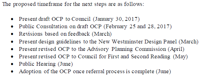
With a busy schedule at the city, and so much election-related angst and chatter and tension and fluff, I found a way to be inspired and challenged in the most positive way on Thursday.

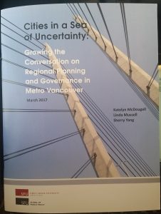
The City Program at Simon Fraser University and the SFU Centre for Dialogue hosted a constructive dialogue on the topic of the Regional Plan, or more on the very topic of regional planning in a Metro Vancouver context. The guiding questions for a compelling 4 hour conversation were:

Is this vision of “Cities in a Sea of Green” still appropriate? Will it sustain us for the next half century? What are the issues our vision must address if it is going to continue to serve the region?

In the room were about two dozen regional leaders from academia, activists and community conversation leaders, planners new and old, and a couple of elected types, both new and old. I would love to list resumes, and attribute quotes (there were many great quotable moments), but the program was run under Chatham House Rule, in order to facilitate freer dialogue. There will be reporting out via the City Program, but what that looks like probably depends on where this new dialogue leads.

In as short a summary as I can muster, my read of the feeling in the room was that the vision and the resultant Regional Plans have served the region well, even as the populations rise, the economy boomed and busted, our economic drivers shifted, and public transit replaced freeways as the ideal connector between city centres. However, there are many flaws in its applicaiton, and many of the current crises challenging the region (affordability, transportation, increasing social alienation) have at least partial connections to the vision itself. The consideration of keeping this vision or developing a new one needs to be measured against its ability to adress our new pressures. There was a broad consensus that this is the time for the Region to be having this conversation, as the pressures right now feel large enough to shift the region in pretty fundamantal ways. I was driven to think about our beautiful, admired, and unique region as being on a precipice.

Instead of trying to summarize the entire diverse conversation here, I would like to touch on just a few points that really hit me.

The conversation we prefaced by a report by a small group of grad students from SFU that looked at the history of regional planning in Greater Vancouver, and the pressures on the current plan:

?

The historic timeline was interesting. A few burgeoning communities collaborating on water and sewer systems in the first half of the last century prefaced an initial dabbling in regional landuse planning driven by the disastrous flood of 1948, but the first comprehensive regional growth strategy emerged in 1966 (where the vision “Cities in a Sea of Green” was first codified). This vision was still of town centers (Vancouver, Surrey, New Westminster, Langley, etc. separated by greenspace and agricultural lands, tied together by freeways, as was the ethos of the day.

The complex history since this time has involved complex relationships between the province and the local government leaders – and there were great forward moves (The 1973 establishment of the ALR, formation of the GVRD, the 1975 Livable Region Plan and 1996 Livable Region Strategic Plan, the 1998 formation of TransLink) and equally important slips backwards (Bill 9 in 1983, which abolished the regional planning function, the 2007 stripping of local governance of TransLink). Tried as I might, I couldn’t correlate the emphasis on regional planning with anything (resource industry boom-bust cycles, global economic shifts, housing prices, Canucks playoff runs) except with the name of the party forming government in Victoria.

That is part of a larger theme that became common: any plans made by the region for the region exists in a larger context of federal and provincial politics and how larger forces look at the purpose of our region.

It was noted that when Simon Fraser introduced the idea of the river that bears his name to the European colonist social media, there were more than 20,000 people living along its banks between Musqueam and Kwantlen. In a very literal sense, he was the first Gateway project planner. His goal was to push a route for hinterland commerce through to the coast, occasionally stopping to seek the permission of the people living there, but not overly concerned with whether that permission was granted. Two hundred years later, the Gateway has other leaders, but the mandate is little changed. As such, the story of the region can be told as a long series of carpet-baggers pushing past the locals for profit. The livability of the region, the ecology that supports it, the local food web and cultural values of the residents are no more important now to the National Enterprise of getting hinterland resources to tidewater than they were in 1808.

It would be ridiculous to equate our current planning frictions the centuries of cultural genocide that took place in North America; the point is only that the fundamental pressures have had similar vectors for a couple of centuries, even at massively shifting scales. There is no reason to asume that founding narrative will change now, and the best laid local and regional plans will fail if the important decisions that shape the region (Port Mann and Massey Bridges spring immediately to mind) are driven by different people working on a completely different plan.

In the end, the strongest feeling I had coming out of this event was (I sure hope @MsNWimby isn’t reading this) a desire to go back to school. To be sitting in a dialogue with people much smarter than me, bringing disciplines together and sharing compelling ideas that force me to shift my own assumptions about a topic so close to my heart was the most fun I have had in a few years.

Why can’t Facebook be like this?

Disgusting (updated)

At some point, a pander to one group of electors goes beyond cynical, and becomes an abdication of responsibility and an offence to the idea of governance.

The BC Liberals platform apparently includes a promise to create a “cap” on bridge tolls – where no driver pays more than $500 per year, regardless of how often they avail themselves of extremely expensive and not-yet-paid-for infrastructure. A great election promise to “put more money in the pockets of hard working British Columbians”, or some such bullshit, but I have to go bullet point to condense my anger about how bad an idea this really is.

  • It completely undermines the Mayor’s Council and the regional transportation plan that they developed. The province has put roadblock after roadblock in place of that plan, while shoveling money to vanity road projects that won’t solve the problem. Just last week they wrapped themselves in benevolent support for the plan with some commitment of financial support of a couple of it’s components. However, it has been clear all along that road pricing and Transportation Demand Management will be major components of the next phases. This cap is a pre-emptive strike against the Mayors, delivered with no warning.
  • This isn’t saving anyone any money. The tolls on the Golden Ears Bridge still need to be paid, because Golden Crossing General Partnership still needs to get paid. Similarly, the tolls on the Port Mann are still owed to TREO, and are already not bringing in anywhere near enough revenue to meet the business objectives of that White Elephant. The Province is going to have to top up these agreements from general revenue – potentially costing taxpayers hundreds of millions of dollars, because use of the bridge above the cap – the tolls taxpayers will have to cover – are actually encouraged by this scheme.
  • This undermines the business plan for the Massey Bridge. We don’t know much about the business plan for the Massey replacement, because the province redacted it to the point that none of the business risk was disclosed. However, the Ministry has been clear through the planning and the Environmental Assessment documents that the 10-lane bridge will be tolled. Tolling was not just a major component of the finances, but was fundamental to the traffic forecasts and environmental impacts for the project. This tosses all of those best-laid plans out the window.
  • It undermines the terms of the MOU for the Pattullo replacement. The stakeholders for the Pattullo have an agreement in place that underlies the ongoing project: a 4-lane tolled structure. Tolls are not just there to pay for the bridge, but to balance the traffic demand between crossings and reduce the impact on residential neighbourhoods of Surrey and New Westminster. A commuter cap on tolls shifts this balance, and sets back a decade worth of progress and partnership on this project, just as we were crossing the goal line.
  • It is counter to basic economics. We are taking a scarce and valuable resource, road capacity, and encouraging its increased use to save money. Simply put – the more you use the bridges, the less you pay. It is insane, and contrary to all Transportation Demand Management best practice across the industrialized world. It is separated from reality. It is deranged. Do I need to get out a thesaurus to make my point here?
  • It is not being offered for any alternatives. It will now, once again, be cheaper to drive a car across the Port Mann Bridge than to take transit across it. Just as the province has been dragged reluctantly into bringing expanded light rail to South of Fraser , they are creating a quick incentive to discourage its use, and undermine the entire model, shifting growth patterns in Surrey for a generation, at the most critical point of its growth.

Now, I am writing this about an hour after this information leaked out, so there may be devil-in-details I am not aware of here that will arrive with the official announcement, but that speaks to the point that there has been no consultation with the Mayors of communities affected, no public engagement over a plan that will re-shape the region and undermine so much of what the region is trying to achieve in livability, sustainable development, greenhouse gas reduction, and transportation. How do you recognize electioneering replacing governance? It is a surprise announcement completely disconnected from any other policy, program, long-term planning, or previous action by the government.

This is a flip of the bird to the regional plan (to the very idea of regional planning!) and to every resident of the Burrard Peninsula. It is a cynical pandering to a few ridings South of Fraser, and low-information voters across the province who likely won’t realize they are going to have to now pay through their taxes for infrastructure built on the promise that users would finance it. Not surprisingly, Jordan Bateman is taking a pass on criticizing this specific tax increase, being the original champion for the Port Mann fiasco.

And people will fall for it, of course. Congratulations, BC Liberals. You have raised the art of disgusting panders to a new level.

UPDATE: I was in the room when John Horgan announced out of nowhere that he would end all tolls on the Golden Ears and Port Mann bridges if elected. The closest thing I have to a response was what James Gemmill made succinct on Twitter:  holdmybeer

RED Talks 2017

A few of us from New Westminster attended the RED Talks event in Vancouver last week, and I was pleasantly surprised by the content of the evening. Red Talks are a local rip riff off of the Ted Talks format, put on by the local development community – RED stands for Real Estate Development. However, it wasn’t developers touting their projects or contributions, it was a conversation about building better cities.

20170330_175222

The organizers were cheeky enough to create a bit of a faux-protest motif for the event, whose theme was “Confronting Consensus”, but the talks actually brought a nuanced conversation about development, housing, and the role of consultation as a discussion between the public and decision-makers. There were probably an equal number of jibes at the Real Estate industry as there was at elected officials, and everyone seemed to acknowledge that the current housing situation in Greater Vancouver isn’t sustainable, or even desirable in the shorter term.

I wished that the folks from Yes in New West were there to be inspired by two of the speakers in particular.

Seth Rogen’s academic brother?

Paul Kershaw has his Generation Squeeze pitch down solidly, and has criticism for pretty much everyone involved in creating a housing market where an entire generation is feeling completely squeezed out. His economic stats were pretty compelling, demonstrating how today’s young professionals are in an entirely different economic universe than their parents, with home ownership being well out of reach for even the most responsible savers.

His call to action is pretty simple: Generation Squeeze has got to get organized, then get active, not just to demand better, but to give decision makers (elected officials, for the most part) the information and vocal support they need to make the sometimes difficult policy decisions that are required to shift our land use.

A perfect example of this call to action was personified in Sonja Trauss of BARF (Bay Area Renters Federation), who is taking a pretty active approach in San Francisco:20170330_192115
San Francisco has, arguably, a bigger housing affordability issue than Vancouver, and faces serious challenges increasing housing stock because of resident push-back against any form of density. The simple truth Trauss realized is that traditional public consultation, when it comes to housing development, completely misses the target. People who will live in new housing never go to the public hearings to support that housing, so the only voice heard at public meetings is that of the people who already have housing near the site of the development. In what other instance do we ask the only cohort who do not want a product to comment on the form of the product?

Her organization tries to break this cycle in San Francisco by organizing active feedback by renters and underhoused people to pretty much every development project in the Bay Area, arguing that rapid increases in regional housing supply is much more important than the (inevitable) parochial concerns.

The talks were rounded out by Nick Buettner of the Blue Zones Project and Steven Levitt, the Freakonomics guy.

The Blue Zones idea is familiar to most urban planning geeks – there are places in the world where combinations of built form and behavior results in longer lifespans and higher quality of life. It is intriguing to learn what lifestyle commonalities may be behind the gerontology anomalies of Okinawa, Sardinia, and Loma Linda, California.

Finally, I may have been the last person on earth to have read Freakonomics, which I did over the Christmas break while on vacation. I found Leavitt in person very much like I found the book: Interesting, but slightly frustrating. Leavitt has a bewildering combination of pattern-seeking insight and intellectual laziness. He finds new ways to pull insight out of noisy data, but then seems to lose interest in the complex interactions that may underlie these patterns – he seems to rush from correlation to causation with reckless abandon, which rubs us in the non-dismal sciences the wrong way. Worse, he response when being called out on this tenancy is essentially to say “Meh”.

All in all, an interesting evening that had me buzzing with OCP energy:

IMG_20170330_1827051

Ask Pat: Medicine Hat

Alice asks—

Is there any reason the Medicine Hat approach of reducing Homelessness in their city can’t be applied to New Westminster? I know it has been said senior gov’t needs to step up but the Medicine Hat strategy involved very little additional funding from senior gov’t. Their population and homeless population appear to be in line with New West.

This is one of the areas of the City’s operations where I have had to climb a pretty steep learning curve. We have Councillors and a Mayor with much more knowledge of this than I do (and some pretty stellar staff, as a bonus), but I’ll take a dive at answering this with that caveat in mind, and keep myself open to correction from those with more knowledge.

Essentially, the Medicine Hat model is based on “housing first” – the idea that if we can first get homeless people into shelter, regardless of how temporary it is, we can get them services they need and start the process of moving them to more permanent and sustainable housing options, and (this is the bigger hope) access to services to help them manage the underlying cause of most homelessness – disabilities, trauma, exploitation, and mental health concerns including addiction. This has been standard operating procedure in New Westminster for a decade or more. So why is Medicine Hat different?

Medicine Hat is a rural community, so it’s 61,000 residents are surrounded by farms and wilderness. New Westminster’s 70,000 people are in the middle of an urban population of 2,500,000 people. New Westminster needs to work along with its neighbours and operate within that reality. That is both an advantage to New Westminster, and a disadvantage.

In Medicine Hat, the most recent homeless count put their numbers at about half the average of the province of Alberta on a per-capita basis. The numbers provided in 2016 news stories estimate there were 875 people moved to supportive housing over the six years of their aggressive program – one for every 70 residents. Extrapolate that to Greater Vancouver, and we would need to facilitate 36,000 supportive housing units in the same period – 6,000 per year. To make this work, the Medicine Hat Community Housing Society received $3.9 million from the province of Alberta (plus about 10% that amount from a combination of the federal and local governments). It is clear the province of Alberta, even during difficult financial times, fulfilled their constitutional responsibility to provide housing. Extrapolate that to the Lower Mainland, and this becomes another boring post about lack of Provincial resources and the terrible priorities of the BC Liberals…

However, there is a persistent problem we have in the Lower Mainland that makes us stand out, and with which “Housing First” is of limited help: the flow of people being forced into homelessness by our out-of-scale housing costs, the erosion of our housing support programs (including the Co-op Housing model), lack of resources for people at risk (aging out of care, coming out of incarceration, or leaving protracted medical care), and our ongoing lack of rental vacancy. To avail oneself of “Housing First” assistance in BC, one first has to be homeless, which is like addressing gun violence by buying bandages: it has a value and is measurably effective, but does not address the source of the problem. This is a terrible way to organize public resources, but more importantly, it completely dehumanizes of the actual problem.

Which brings me back to the Medicine Hat miracle I keep reading about in the news. Considering it is not particularly groundbreaking in approach, and aside from the resources put into it, it’s success is not outstanding compared to many municipalities (including New Westminster), I wonder about the narrative of its success. I do not want to take even the tiniest bit of credit away from the City, the not-for-profits, or programmers (paid and volunteer) who put their lives work into helping less fortunate people, but there is a part this makes me twitchy.

Google any story of the Medicine Hat Homelessness approach, and you hear some version of the same narrative: how the “fiscally conservative” Mayor was convinced to support the program, because it turns out paying to put people in housing saves the City and the Province money in the long run. Now, this is true; so well established it isn’t even a point of debate, but quotes likes this fire my cynicism gland:

“It makes financial sense. That’s how I had my epiphany and was converted. You can actually save money by giving somebody some dignity and giving them a place to live.” – Mayor Clugston

The fact that a leader describes his decision to provide basic human dignity to marginalized residents of his community in terms of its ability to turn fiscal profit is abhorrent to the way I view governance and society. Maybe he is just saying that to keep the Randian libertarians in his town off of his ass, or perhaps it speaks deeply of the state of western Canadian politics and the erosive influence of Calgary School neo-liberal fiscal policy projected by “Think Tanks” like the Fraser Institute on governments at all levels… I’m about to go on a long rant here, so perhaps I will save that for a future blog post… but this economically-driven “come-to-Jesus moment” narrative sound more like cowardice than visionary leadership to me.

Short version is we, in New Westminster, are regional leaders in providing housing support to our homeless residents, and I will hold our success up against Medicine Hat’s any day (not that this is a contest – when it comes to supporting marginalized populations in this country, we are all losing). New West is forging partnerships with senior governments and investing in supportive housing, and we are providing City lands to develop innovative housing solutions. We have incredible staff and NWPD liaisons partnering with an amazing suite of not-for-profit agencies to address the multiple causes of (and solutions to) homelessness at a person-to-person level. We did this before it was sexy, and perhaps we don’t brag enough about it. More importantly, I would like to think we do it not becasue of some fiscal bottom line calculation, but because homeless people in New Westminster are citizens of New Westminster, who deserve representation for their elected officials, and should have the same access to support, dignity, and opportunity as everyone else.

Ask Pat: Anvils and elephants

Duke of Belyea asks—

Hi Pat, perhaps the notion of the Anvil Center being a white elephant could be dispelled if you or the City could show the actual revenue/expense numbers for the facility.

First, on the premise, I disagree with you. Second, on the solution, I wish it was that simple.

I do not think critics of the Anvil Centre (or indeed critics of Council) will ever be convinced that it is anything but a white elephant. Specific residents of Coquitlam will write occasional long-winded factually-challenged screeds to the Record for some time, using the Anvil as an example of New Westminster’s failures, regardless of any success seen around or within the Anvil. That is just political bullshit theatre we need to live with, and facts will not change it, because the Anvil is more than building, it is a totem around which previous elections were fought and lost. Some people never stop fighting yesterday’s battles.

The premise further relies on measuring the success or failure of Anvil on a balance sheet of effort-in & revenue-out. I simply don’t see it that way. To explain that, we need to clarify what the Anvil is, and what a City does.

For one building, The Anvil Centre has purposes to fill a long paragraph (noting, for full disclosure, that I was not on Council when these conversations and decisions were made):

The Office Tower was conceived as an economic driver for Downtown, but since the City sold it off for more than it cost to build (success?), the City no longer had much say in how it is operated. The owners have every right to set their rent and manage their incentives any way they see fit, regardless of whether it serves the larger purposes of the City. The restaurant space is finally leased, and although later than we may have liked, I think we will have an operating restaurant that fills a niche in the City, brings attention to Columbia and 8th, and becomes a revenue driver for the City. I’m not sure how you measure the success of the shift of the Museum, Archives, and Lacrosse Hall of Fame to this venue. They have been relocated from various other locations to a central cultural hub, which also freed up space in those other venues. The New Media Gallery has quickly become one of the region’s most important artistic venues, drawing visitors and raves from around the region. Conference services are on or ahead of target for bookings and revenues, the program at the Theatre is (slowly) coming along, and the numerous arts and culture programs on the 4th floor are similarly starting to fulfill the original vision for activating the Arts in our City. All of these tangible purposes are wrapped up in the larger benefit of turning a windfall (the DAC funding) into a community asset to replace a failing retail strip at the renewed gateway to our central business district.

This brings us to your solution to the inevitable political push-back: a simple spreadsheet that outlines the costs and recoveries from the Anvil. I suppose it is doable, as the City’s Financial Plan and backing documents are openly reported, and every input and output is buried in those spreadsheets somewhere. But it would be really complicated, simply because the Anvil is not a single entity operating separate from the rest of the City.

The museum and archives have always cost money to operate; moving them to the Anvil doesn’t change that. The old Hall of Fame site is now home to a very popular and revenue-generating recreation program: is that success part of the Anvil, though it is located at the Centennial Community Centre? The City’s Arts Programmer works out of the Anvil, but also administers the City’s Public Art program, which is funded through a combination of fees, sales revenues, and taxes – how does that balance sheet overlap with Anvil’s? Even the Conference Services, which are a revenue-generation aspect of the Anvil, share resources with other departments (especially the theatre and our catering contractor), and rely on an integrated operation to be successful. There are staff who spend part of their time doing Anvil-related things, and part of their time working at other facilities, just as the toilet paper and photocopier toner at Anvil are bought as part of City-wide operations. The tax revenue for the office tower is higher than it was when the space was a one-story retail space, but that tax enters general revenue, and needs to be measured against opportunity cost if a private developer had taken over that site… the list goes on.

I guess it sounds like I am creating a list of excuses of why not, instead of addressing your original concern. Lyrical gentlemen from Coquitlam will accuse me of “spinning” the facts here for political reasons – the same way they would accuse any spreadsheet produced of doing the same thing. So if you want a spreadsheet to solve a political problem, I suggest it won’t work. So why spend valuable staff time producing it?

I tend to agree with one idea buried in your premise, and maybe an answer to that last question: we need to find a better way to share our financial information in the City. Although all reporting is “open”, I am afraid our efforts towards “transparency” is a little clouded by the complicated way that Public Service Accounting Standards are regulated and performed. Even as a City Councillor exposed to this stuff all day, I am sometimes challenged to create connections between line items in spreadsheets. There is a lot of Accountant Talk here, and with all due respect to the profession, they are no better than others at explaining to lay people just what the hell they are doing. I’m not sure what the answer is from a public engagement viewpoint, but suspect (hope?) we can do better. I’m just not sure it will ever be enough to satisfy some Letter-to-the-Editor authors, and maybe that shouldn’t be our goal. However, we do need to find ways to translate our financial reporting so residents and businesses can be confident that their money is being spent wisely.

I am pretty sure of one thing: any honest accounting would reveal the City spends more money on operations at the Anvil than it receives in revenue from Anvil operations. Just as it spends more money on the Canada Games Pool than revenue earned, or the all-weather playing field at Queens Park, or the Queensborough Community Centre, or the Library. I suppose there is a discussion that could be had about which of these operations community assets would need to show a financial profit to be considered “successful” in the City, but I don’t think that is where you were going with this question.

I also think there are improvements we can do to make Anvil run better, especially in opening up the first floor to more public use and making the entire centre more inviting. That is an ongoing discussion, and one very much worth having.

Ask Pat: The Sub

Eric asks—

Ahoy Capt. Re: Das Sub

Great the Quayside playground is up for a needed rebuild. Has “what do we do with the submarine” come up?

After all this item has quietly slipped into historic artefact/ community heritage resource status.

We all know it came from Expo ’86. What might not be as well known: it was from a West Edmonton Mall attraction (at the time the mall had more working subs than the Cdn. navy); at Expo it was part of the brilliant public art piece Highway ’86 by James Wise of SITE, a cutting edge design firm all us young architects were in awe of.

The sub was the largest of dozens of transportation, including a tricycle and an aeroplane, all painted matte grey and set on an undulating grey asphalt “road”.

How about we hand the sub over to the Public Art Cttee. to reprise/resurface it in a new location? Our local transpo crowd – including a certain councillor- might get right into it.

Yes, the topic of saving or moving the semi-Sub has come up. Staff have even spent a bit of time looking at potential options. However, at the risk of sounding like a boo-bird, I need to point out some of the significant technical challenges staff have related to me about trying to save and/or move the Sub.

The Sub can’t stay where it is. The storm drainage pipe under it needs to be excavated and replaced, that is not an optional thing, but something the City needs to get done before compete failure of the pipe and related flooding. Try trying to remove the sub in one piece presents several challenges (not to mention the unknown unknowns, to borrow a phrase). It will need to be separated from the foundation built to support it, and the entire concrete-over-steel structure would have to be lifted and moved, which if not done with great care (read: expense) may end the entire “in one piece” part of the discussion.

20170308_112210(0)

The Submarine itself would need extensive restoration if it was to be made a permanent art installation, as the steel is not in great shape based on the concrete delamination and spalling – the piece was built for a 6-month installation 30 years ago. The modifications of it to install it in the park (removal of the wings, installation of the railing) probably didn’t help, nor did the various coats of paint that are now peeling off of, regardless is whether the concrete overcoast comes with it or not. We currently have no budget for, and have not even had evaluated, the form of this restoration, however safe to say it will be significant.

We have nowhere to put the submarine. If we remove it, we would need to find a place to store it where it can be protected from the elements, and where restoration work can happen. Unless a generous benefactor with spare warehouse space was to come along, I’m not sure where we can do this.

Finally, and this is, unfortunately, the biggest issue with all of the above – we have very little time to get the pipe replacement work done. As much of the drainage involves an excavation within the wetted area of the river, the work needs to be done within a “fisheries window” – a short period of time when Fisheries and Oceans Canada have given us permission to do the work in order to minimize the disruption of fisheries habitat and the injury of fish. Again, this is not something we have any control over, and that is creating a very, very tight timeline for the work, and it will be starting very soon. An extra week or two to design, coordinate and execute a potentially delicate removal plan for a piece we have no long-term plans for would be perilous. Never mind trying to find the (estimated – with significant contingency) tens of thousands of dollars to do the removal work.

As for the Heritage value, there already was a preliminary assessment of the Sub. The value is considered very limited and “sentimental”, but not representing a significant heritage artifact. Its provenance is not New Westminster, and it is separated from its context. Although there are legends about a connection to West Edmonton Mall, in reality the submarine was the only machine of the 200 that made up the Highway 86 installation that wasn’t a real, operating machine before it was installed. It is a semi-sub; half of a fake boat. The “U” in this U-boat stands for “Unecht”. You get the message.

That said, on kitsch value alone I’m not opposed to the idea, and wish we had more time to allow someone passionate about such a plan to cook up a solution to the above concerns. Problem is, this project has been discussed and on the books for many months (including a few public consultation rounds and public meetings), and the topic of saving the submarine has not been put forward as an important component of the engineering work or playground replacement. I also touched bases with a few people in the Publci Art realm, and they were… underwhelmed. Unfortunately, we are now well past the eleventh hour, and jeopardizing the timeline and budget of the planned work for the site at this point would be irresponsible.

So in sumary, I’m going to suggest this is an interesting idea, likely impractical, definitely costly, and probably undoable considering the pressures on the City to get the engineering work at the Quayside done. I would suggest the submarine is finally heasded off towards the sunny horizon it has pointed at for more than a generaiton: the metal recycling and junkyards south of the Fraser.

20170308_112433

Demoviction Conversation

Amongst the joys of my job as a City Councillor is collaboration with other elected types around the region who are trying to solve regional problems in new ways. I’m also a bit of a data geek, so I love getting new information and learning from people much smarter than me who have innovative approaches to problems.

In the interest of bringing these things together, I am working with some pretty cool colleagues to develop a “MetroConversations” series. We had a successful first event in New Westminster last November, and have plans to expand and grow the program in 2017. The second in the series is happening in Langley City next week, hosted by the brilliant and telegenic City Councillor Nathan Pachal

The topic is as relevant in New Westminster as anywhere in the region: How do we replace an aging stock of rental buildings without displacing people who rely on an affordable rental building stock?

There has been a lot of talk about this in the City of Burnaby, and although they get a (perhap unfair?) majority of the press, this is truly a regional concern. The City of New Westminster has done a lot to incentivise the building of family friendly apartment housing, secured rental housing, and other housing forms in the hopes that we can eat away at the affordability monster. We also have a huge stock of condo and rental buildings, mostly in Brow of the Hill and Sapperton, that are aging and don’t meet modern building standards. At some point, replacement of this stock is going to create a Burnaby-like situation, unless we take a proactive approach to the issue. That said, who knows what that proactive approach looks like?

This MetroConversation will feature people who have a better idea of what works and doesn’t when it comes to managing our affordable housing stock – actual subject matter experts who view the issue from diferent angles. As always, this will be an interactive conversation, not a boring set of speeches. Bring your questions, bring your ideas, and help add to the conversation in the region.

The room is relatively small (we want an intimate conversation) so please be sure to register to make sure you can get a seat, we totally expect to sell out.

MCbanner

TransLink Fare Review

Now that we are all used to having a Compass Card, and even whingy, retro-grouch, late adopters like me have adapted and find the payment system easier to use, it’s probably a good time to discuss whether the current payment system for public transit makes sense. Fortunately, TransLink is doing that right now.

The system used by TransLink now dates back to the BC Transit days, more than 30 years ago. The familiar zones, transfers, off-peak discounts, and concession fares have only been tinkered with since the SkyTrain was shiny and new. The shift to single-zone buses to accommodate Compass Card was probably the biggest system-wide shift, but the arrival of Compass and long-awaited expansion of transit service make this a good time to review if the system we have really serves its customers best.

As New Westminster is the community that relies on transit more than any other on a per-capita basis, I hope people in New West take the opportunity to take part in the on-line survey and share their ideas.

Fares paid by transit users represent about 37% of TransLink’s revenues, a little over $510 Million out of total revenues of $1.4 Billion. However, it is not the intention of the ongoing fare review to increase the amount of revenue generated from current users. It is more about making the system more efficient and more attractive to users, which may result in increased revenue through boosted ridership.

At this point, TransLink are asking three simple, high-level questions, although each leads to longer discussions about how we want our transportation system to work, and what we want it to be. They are described in more detail here, but my short version is:

1) Zones: Should there be a flat fare for the system regardless of distance traveled, or should people pay more to travel further? If the latter, how fine-grained do you want zones to be? We currently have 3 zones for SkyTrain and one for bus and separate ones for YVR and West Coast Express, but could easily break the region up into 10 or more zones, or create “floating” zones where the edges shift based on where you first enter the system.

2) Travel Time: Should you always pay the same rate to ride transit, or should TransLink continue to give discounts outside of the busiest hours to try to spread the load (and crowds) across the system? If the latter, should there be only a Peak and an Off-Peak rate, or should the rate shift throughout the day, even hourly?

3) Service Type: Should all transit cost that same, or should you pay more for SkyTrain than you do for a bus; more for B-lines than for regular buses; different rates for West Coast Express and SeaBus? Perhaps more provocatively: should we have “business class” buses, with WiFi and cushy seats and foot massage for a premium cost?

I have my own opinions (surprise!) on all three of these topics. I even got to share them at a stakeholders meeting for elected types a few weeks ago. Fortunately, I also got to hear differing opinions on each of the points from people around the region. Most of these arguments discussions ended up circling around providing a “simple” system vs. a “fair” system. I tended towards the latter argument, mostly because I want a system that works for the day-to-day users and encourages use by residents of the region, and am less fussed about whether the system is quickly understood by tourists. I’ve traveled in transit systems in lots of countries in the last few years. Whether it was New York’s flat $2.75 a ride or Singapore’s highly variable distance-based sliding rates, we always managed to figure it out very quickly, and with a digital cards, it was never enough of a hassle that it made riding transit difficult.

I was also very curious about how any future payment system would be integrated with a regional road pricing scheme. It has always bugged me that tolls to cross the river or the Burrard Inlet have always existed for transit users in the form of “zone boundaries”, but driving across the bridges remained toll-free. If we want to leverage fair pricing of our regional transportation network towards Transportation Demand Management goals, the fare system must be integrated.

Finally I have a bunch of opinions (surprise!) about other aspects of the TransLink fare system. Why do we charge youth when they are travelling with their parent? Where are the employer incentive programs? Why am I paying an extra $7 at YVR? But these are not part of the current discussion. That type of fine-tuning and incentive program development will need to be a new discussion once TransLink has scoped out a renewed fare model based on the three principles above.

So go and take the survey, please, in the next couple of days, and give TransLink a bit of guidance about how you use the system, and how you want to pay for it. Make it work better for you, and for the region.

Census 2016 (part 1)

The 2016 Census data is starting to trickle out. I’m not sure if it is for dramatic effect, or if different data sets require different massaging levels, but the info you and I provided Stats Can in 2016 will be released in several stages through 2017. The first tranche, released this week, is population and residential dwelling count per census tract, along with numbers that can be calculated from those, like population change since 2011, population density, and residential vacancy rate.

growth
…from Canada Census website.

It should be no surprise to anyone that New Westminster is growing. Just a little under 71,000 people called New Westminster home in 2016. In terms of population growth, New Westminster grew about 7.6% over those 5 years (which works out to an average of about 1.2% increase per year). This rate of growth is above the average for Vancouver (6.4%), BC (5.6%), and Canada (5%).

There is a website called CensusMapper where the raw census data is popped into a map of census tracts as it becomes available, providing quick analysis opportunities for data geeks (like me).

Density is a simple measure of the number of residents per square kilometre, and density is one area where New Westminster leads the nation (by some estimates, we are the 4th or 6th densest Municipality in Canada). This s a result of several factors, including us having a relatively small land base (only 11 square kilometres), 150+ years of being the centre of expanding hinterlands that created their own local governments, and our being largely built out as an urban community. It is no surprise that Downtown and the Brow are the densest parts of the City, Queens Park and the industrial areas the least dense:

INSERT DENSITY 1 (image extracted from Censusmapper.ca)
Population Density, persons per square km. (image extracted from Censusmapper.ca)

There are a few things off with this presentation, as the census tracts include areas like the river and park land, so the east half of Queens Park neighbourhood is shown as less dense than the west half, which does not necessarily reflect the true residential density differences on either side of Second Street. In the image below, I highlighted in orange a downtown tract that is biased by including the river – without the river, it may be darker purple like the adjacent tracts.

INSERT DENSITY 1 (image extracted from Censusmapper.ca)
Population Density persons per square km. (image extracted from Censusmapper.ca)

Finally, there are some interesting patterns in the Population Growth plot. It is clear (and not surprising) that growth is not evenly distributed throughout the City. We have been building a lot of family-friendly ground-oriented “missing middle” housing in Queensborough, and that has led to predictable growth. Areas where we have towers and other forms of multi-family dwelling are growing, with only very moderate growth in the West End and other single family neighbourhoods. The only surprise is that the Connaught Heights neighbourhood, during significant regional growth driving an ongoing housing crisis, somehow shrank in population.

INSERT Popgrowth (image extracted from Censusmapper.ca)
Percentage population gr0wth, 2011-2016 (image extracted from Censusmapper.ca)

This is a concern. Both our City’s long-range planning and the regional planning documents depend on concentrating growth along rapid transit lines, for a variety of sustainability and livability reasons. We have slower growth around Braid and Sapperton Stations than in the relative transit desert of Queensborough, and actual population loss around 22nd Street Station. Keep this in mind as we discuss the OCP in the months ahead.

More than the map

I know a few people showed up at Council today, hoping to talk about the Official Community Plan and Land Use Map. Unfortunately, it was a Public Hearing night, as the last meeting of every month usually is, and as such we generally don’t have Public Delegations on those nights, saving space in the Agenda and reserving the floor for people who would like to talk to Council about items on the Public Hearing.

Worry not, there will be lots of opportunity for you to talk to Council about the OCP, as the entire draft Plan will be going out to Public Open houses in February. That was the decision made by Council today during our mid-day Workshop, which you can watch here, if you want to get a sense of where Council is on this topic, the conversation was wide-reaching and at times challenging.

You might want to look at the Land Use Map (as that seems to be where most of the conversation has been up to now), but you may also want to delve into the entire OCP document. This is a 150-page document that draws a much more detailed map of where the citizens of New Westminster see the City going over the next 10 to 25 years.

(You can click here to open the Council document from today’s Workshop, skip ahead to page 128, unless you also care about Heritage Protection in Queens Park!)

Under an overarching Vision Statement, there are 7 major Themes. These Themes support 12 Goals, which are descriptions of how we will describe the City in 25 years. To reach those Goals, there are 61 proposed Policies and 175 Actions that the City will take. It is only after reviewing those intended Actions that the Land Use Map and Land Use Designations make sense. The map should, if the OCP is on the right track, support those Policies and Goals, and ultimately, the Vision. And I want to talk about that.

New Westminster is a healthy, inclusive and thriving community where people feel connected with each other.  This sustainable city showcases a spectacular natural environment, public spaces and unique neighbourhoods that are well-connected and accessible. Superior urban design integrates its distinctive character, heritage assets and cultural identity. Growth and development provide a variety of services and employment opportunities that contribute to a high quality of life for all.”

When we started this process, almost three years ago, there was a burgeoning housing crisis in the Lower Mainland. In the two years since, the situation has gotten measurably worse. Accessibility to housing and affordability of housing is at critical levels in New Westminster, with 30% increases in property values in the last 12 months alone – ground oriented housing increased at more than that rate.

Over the last decade (and notably, mostly before my time, so I get little credit here) New Westminster has made real progress in addressing homelessness, in creating incentives to address the critical rental shortage, and in supporting the development of more affordable apartments and sustainable densities around our SkyTrain hubs. However, the “Missing Middle” is still a challenge. This OCP, and drafted, will open up possibilities for a variety of housing forms in some areas, and I appreciate the increased flexibility offered in the “ground oriented Infill” designation.

Just two weeks ago, we had a Council Report on the City’s Business Survey, and one of the biggest concerns of our business community was the loss of affordable family housing: for their employees and for their customers. Affordable family housing and housing variety isn’t just the biggest issue in our housing file, it is the biggest issue in our business development file, our transportation file, and our sustainability file.

I hope that during this last round of public consultation, we can correct some of the misinformation that lead to some relatively concentrated but sincerely-felt push-back, and can continue the ongoing three-year-long conversation about the context of this OCP and the future vision for the City that it presents. As part of that, we need to ask ourselves – have we done all we can to assure our family neighbourhoods can remain family neighbourhoods, accessible to the young families that will make our City prosper in the future? Have we provided opportunities for people from all walks of life and from all stages of life, to live in New Westminster and contribute to the vibrancy of this great community? Have we addressed regional affordability challenges and shown the leadership our residents expect from us?

So we are taking this back out to Open Houses, and I hope our residents and businesses ask themselves if this plan it meets their vision for that “healthy, inclusive and thriving community”.

The schedule ahead:

schedule